
Hartsfield/Jackson Atlanta International
ATL · KATL · Atlanta, Georgia · Fulton County · map
Hartsfield/Jackson Atlanta International is a public-use airport owned by the City of Atlanta, 7 miles south of Atlanta, Georgia, 1,026 feet above sea level. It has 5 runways; the longest, 09L/27R, is 12,390 feet of concrete. It has a control tower, fuel (100 octane avgas, 100LL avgas, Jet A) and 3 based aircraft. The FAA counts about 791,067 takeoffs and landings a year. About 45,449,813 passengers boarded flights here in the FAA's fiscal year 2024.
Weather right now KATL · observed 5:52 pm EDT (21:52 UTC), 60 minutes ago
VFR good flying weather
- Wind from the east (080°) at 10 knots
- Visibility 10 miles or more
- Sky: a few clouds at 20,000 feet
- Temperature 76°F (24°C), dew point 52°F (11°C)
- Altimeter 30.02 inHg
The forecast issued Tue 5:50 pm EDT (21:50 UTC), good until Wed 8:00 pm EDT (00:00 UTC)
- From Tue 6:00 pm EDT (22:00 UTC): wind from the east at 9 knots, visibility more than 6 miles, a few clouds at 20,000 feet VFR
The codes as issued (METAR and TAF)
METAR KATL 062152Z 08010KT 10SM FEW200 24/11 A3002 RMK AO2 SLP158 T02440111
TAF KATL 062150Z 0622/0724 08009KT P6SM FEW200
From the National Weather Service's aviation weather service, refreshed every few minutes; times are local to the airport with UTC in brackets. For a flight, get your briefing from Flight Service or an approved provider.
The airport
- Codes
- FAA ATL · ICAO KATL
- Kind
- Airport · open to the public · publicly owned
- Owner
- City of Atlanta
- Elevation
- 1,026 feet above sea level
- Control tower
- A control tower · around the clock
- Attended
- around the clock
- Lights
- beacon sunset to sunrise
- Fuel
- 100 octane avgas, 100LL avgas, Jet A
- Repairs
- airframe: major repairs; engine: major repairs
- Parking
- hangar
- Notes
- landing fee · certified for airline service (Part 139)
- On the chart
- Atlanta sectional
- Magnetic variation
- 5W
- In the FAA's files since
- September 1942
Runways 5
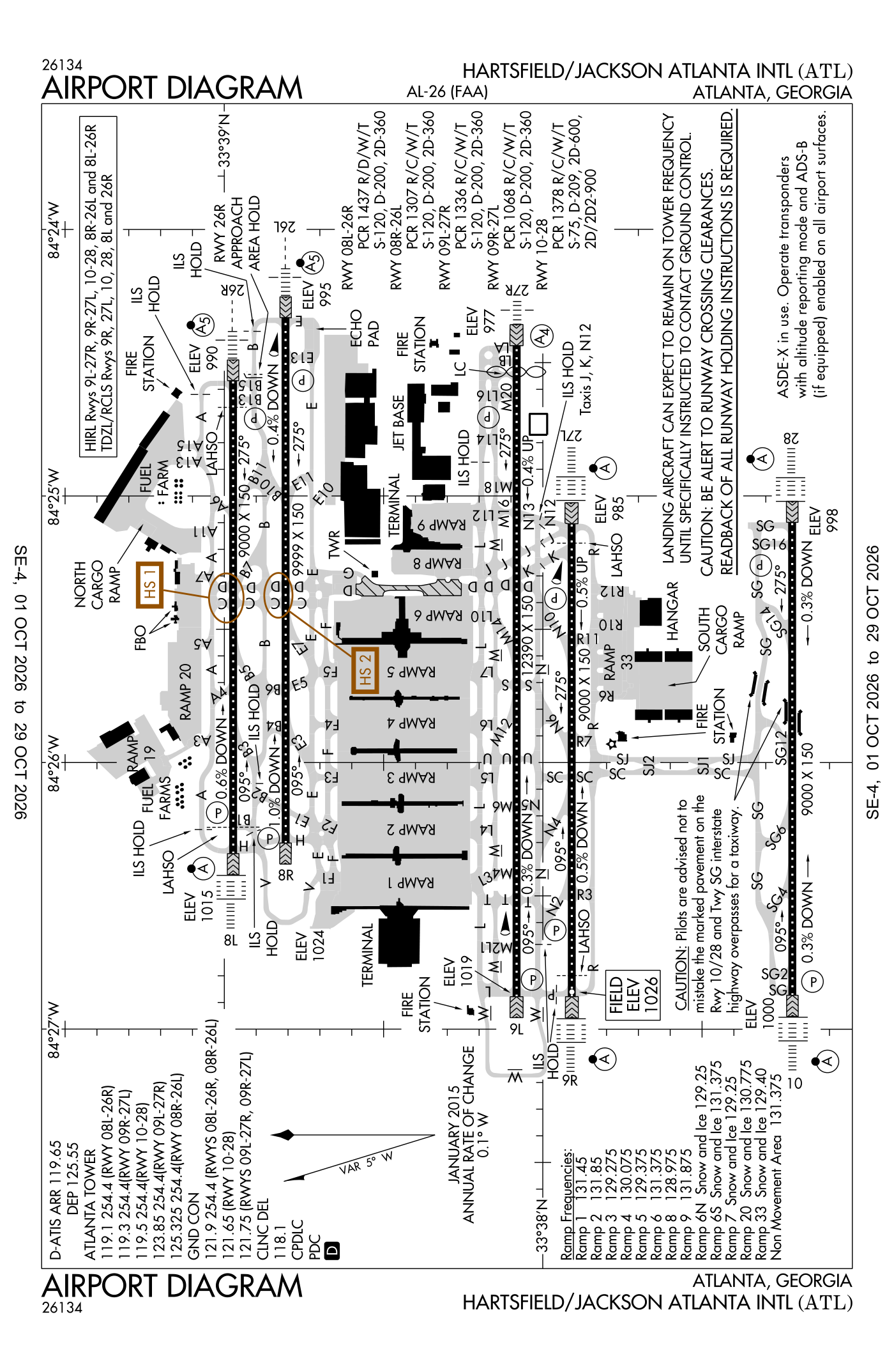
For understanding the field, not for navigation.
| Runway | Length × width | Surface | Lights |
|---|---|---|---|
| 09L/27R | 12,390 × 150 ft | Concrete, good | High-intensity lights |
| 08R/26L | 9,999 × 150 ft | Concrete, good | High-intensity lights |
| 08L/26R | 9,000 × 150 ft | Concrete, good | High-intensity lights |
| 09R/27L | 9,000 × 150 ft | Concrete, fair | High-intensity lights |
| 10/28 | 9,000 × 150 ft | Concrete, good | High-intensity lights |
- Runway 09L: ILS with DME, PAPI, four lights on the right, 11,730 ft available for landing, tank 110 ft high 3,937 ft from the end
- Runway 27R: ILS, PAPI, four lights on the right, medium-intensity approach lights (MALS), threshold displaced 500 ft, 11,890 ft available for landing, tree 62 ft high 2,527 ft from the end
- Runway 08R: ILS with DME, PAPI, four lights on the left, tree 94 ft high 2,832 ft from the end
- Runway 26L: ILS with DME, PAPI, four lights on the left, medium-intensity approach lights with runway alignment lights (MALSR), tree 26 ft high 517 ft from the end
- Runway 08L: ILS with DME, PAPI, four lights on the left, approach lights with sequenced flashers (ALSF-2), 8,800 ft available for landing, tree 116 ft high 3,604 ft from the end
- Runway 26R: ILS with DME, PAPI, four lights on the left, medium-intensity approach lights with runway alignment lights (MALSR), 8,500 ft available for landing, tree 45 ft high 940 ft from the end
- Runway 09R: ILS with DME, PAPI, four lights on the left, approach lights with sequenced flashers (ALSF-2), pole 136 ft high 4,497 ft from the end
- Runway 27L: ILS with DME, PAPI, four lights on the right, approach lights with sequenced flashers (ALSF-2), 8,865 ft available for landing, tree 56 ft high 2,259 ft from the end
- Runway 10: ILS with DME, PAPI, four lights on the right, approach lights with sequenced flashers (ALSF-2), right-hand traffic pattern, tree 84 ft high 2,820 ft from the end
- Runway 28: ILS with DME, PAPI, four lights on the right, approach lights with sequenced flashers (ALSF-2), tower 136 ft high 4,240 ft from the end
Radio frequencies
| UNICOM | 122.95 | |
| Digital ATIS Arrival | 119.65 | Atlanta |
| Digital ATIS Departure | 125.55 | Atlanta |
| Clearance delivery | 118.1 | Atlanta |
| Ground Runway 10/28 | 121.65 | Atlanta |
| Ground Runway 09L/27R, 09R/27L | 121.75 | Atlanta |
| Ground Runway 08L/26R, 08R/26L | 121.9 | Atlanta |
| Tower Runway 08L/26R | 119.1 | Atlanta |
| Tower Runway 09R/27L | 119.3 | Atlanta |
| Tower Runway 10/28 | 119.5 | Atlanta |
| Tower Runway 09L/27R | 123.85 | Atlanta |
| Tower Runway 08R/26L | 125.325 | Atlanta |
| Approach · Chppr and star · Glavn and star | 128.0 | Atlanta |
| Approach · Gndlf and star · Hobtt and star arriving from headings 090 to 269 | 134.725 | Atlanta |
| Atlanta and dp · Departure procedure (BANNG) · Departure procedure (CUTTN) Runway 10/28 | 121.225 | Atlanta |
| Atlanta and dp · Departure procedure (BANNG) · Departure procedure (CUTTN) Runway 09L/27R, 09R/27L | 125.65 | Atlanta |
| Atlanta and dp · Departure procedure (BANNG) · Departure procedure (CUTTN) Runway 08L/26R, 08R/26L | 133.475 | Atlanta |
| Emergency | 121.5 | Atlanta |
| Bukhd and star | 121.0 | Atlanta |
| Final approach Runway 09L, 09R, 27L, 27R | 124.6 | Atlanta |
| Dehan and star | 126.975 | Atlanta |
| Final approach Runway 08L, 08R, 26L, 26R | 127.25 | Atlanta |
| Ondre and star · Ozzzi and star | 128.525 | Atlanta |
| Ramp and ctl Ramp 8 | 128.975 | Atlanta |
| Ramp and ctl Ramp 6N snow and ice; Ramp 7 snow and ice | 129.25 | Atlanta |
| Ramp and ctl Ramp 3 | 129.275 | Atlanta |
| Ramp and ctl Ramp 5 | 129.375 | Atlanta |
| Ramp and ctl Ramp 33 snow and ice | 129.4 | Atlanta |
| Ramp and ctl Ramp 4 | 130.075 | Atlanta |
| Ramp and ctl Ramp 20 snow and ice | 130.775 | Atlanta |
| Ramp and ctl Non movement area; Ramp 6 | 131.375 | Atlanta |
| Ramp and ctl Ramp 1 | 131.45 | Atlanta |
| Ramp and ctl Ramp 2 | 131.85 | Atlanta |
| Ramp and ctl Ramp 9 | 131.875 | Atlanta |
| Prm Runway 09L/27R, 09R/27L | 132.55 | Atlanta |
| Prm Runway 10/28 | 133.425 | Atlanta |
| Final approach Runway 10, 28 | 135.375 | Atlanta |
Automated weather (ASOS), by phone 404-559-5166.
Based aircraft as counted for the FAA, fiscal year 2024
Takeoffs and landings a year about 791,067, the FAA's fiscal year 2024 (October 2023 to September 2024)
Local flights stay in the traffic pattern or nearby, often practice; travelling flights arrive from or leave for somewhere else. Counts at airports without a tower are the FAA's estimates.
Wind map live wind over the area, from Windy.com
Colours show wind speed, the moving lines its direction; drag the time bar for the coming days. Map and forecast by Windy.com.
Aircraft registered in Atlanta from the FAA register
1,591 aircraft are registered to owners in Atlanta, Georgia: 1,124 airliners and large jets, 230 piston singles, 107 business jets, 38 drones, 30 piston twins. Not every one of them is based at this airport; the based-aircraft count above is the FAA's figure for this airport alone.
Companies and organisations in town with two or more aircraft:
Individuals are counted, never named. All aircraft registered in Georgia.
Accidents and incidents at or near this airport NTSB records · 84 since 1982, 2 fatal
Cases the NTSB recorded with this as the nearest airport, newest first. Each opens the full report in plain English.
Nearby within 30 nautical miles
The FAA's remarks as written in the airport file
- Rotating beacon located south of taxiway R7, north of taxiway SJ2 NR fire station.
- PAPI runway 26L unusable beyond 7 degrees left and right of rcl.
- PAPI runway 26R unusable beyond 6 degrees left and 7 degrees right of rcl.
- Concrete hopper
- Be alert to runway crossing clearances. Readback of all runway holding instructions is required.
- Preferential runway use in effect, expect to use runways 08R/26L, 09L/27R for departures; runways 08L/26R, 09R/27L are used primarily for arrivals.
- All runways, touch and go operations, low approaches, and practice instrument approaches not permitted.
- Aircraft with a wingspan of greater than 214FT are restricted from using taxiway F east of ramp 5 north and west of taxiway D.
- Aircraft with wingspan greater than 171 feet are rstrd from using taxiway V. aircraft with wingspan greater than 171 feet are required to use taxi speeds less than 15 mph when passing aircraft with wingspan greater than 214FT on txwy L/M (east of L7).
- Runway 9L departures can expect intersection departure from M2 with runway remaining 11,440 feet (tora/toda) and 10,780 (asda).
- All aircraft with wingspans greater than 214 feet are required to use taxi speeds not greater than 15 mph on taxiways a, L, M, and SJ.
- When aircraft with wingspans greater than 214 feet are present on the field, all other aircraft must adhere to the taxiway centerline on taxiways L and M, taxiways east and F, and taxiways SC and SJ between SG and R due to separation between the parallel taxiways.
Facts from the FAA's airport file effective October 1, 2026, written out in plain English; weather from the National Weather Service's aviation weather service; registered aircraft from the FAA register as of October 5, 2026; accidents from the NTSB's public database. Owners are shown only when they are an organisation; no person is named. Check the official sources before a flight: this page is for understanding an airport, not for planning one.