
Fort Worth Meacham International
FTW · KFTW · Fort Worth, Texas · Tarrant County · map
Fort Worth Meacham International is a public-use airport owned by the City of Fort Worth, 5 miles north of Fort Worth, Texas, 710 feet above sea level. It has 4 runways; the longest, 16/34, is 7,502 feet of concrete. It has a control tower, fuel (100LL avgas, Jet A, Jet A-1 with additive) and about 299 based aircraft. The FAA counts about 216,739 takeoffs and landings a year. About 2,379 passengers boarded flights here in the FAA's fiscal year 2024.
Weather right now KFTW · observed 5:53 pm CDT (22:53 UTC), 38 minutes ago
VFR good flying weather
- Wind calm
- Visibility 10 miles or more
- Temperature 85°F (29°C), dew point 46°F (8°C)
- Altimeter 29.95 inHg
The forecast issued Tue 6:20 pm CDT (23:20 UTC), good until Wed 7:00 pm CDT (00:00 UTC)
- From Tue 7:00 pm CDT (00:00 UTC): wind light and variable, visibility more than 6 miles, clear skies VFR
- From Wed 1:00 pm CDT (18:00 UTC): wind from the east-northeast at 6 knots, visibility more than 6 miles, clear skies VFR
The codes as issued (METAR and TAF)
METAR KFTW 062253Z 00000KT 10SM CLR 29/08 A2995 RMK AO2 SLP136 T02940078
TAF KFTW 062320Z 0700/0724 VRB03KT P6SM SKC FM071800 06006KT P6SM SKC
From the National Weather Service's aviation weather service, refreshed every few minutes; times are local to the airport with UTC in brackets. For a flight, get your briefing from Flight Service or an approved provider.
The airport
- Codes
- FAA FTW · ICAO KFTW
- Kind
- Airport · open to the public · publicly owned
- Owner
- City of Fort Worth
- Elevation
- 710 feet above sea level
- Control tower
- A control tower · around the clock
- Attended
- around the clock
- Lights
- runway lights sunset to sunrise; beacon sunset to sunrise
- Fuel
- 100LL avgas, Jet A, Jet A-1 with additive
- Repairs
- airframe: major repairs; engine: major repairs
- Parking
- hangar, tiedown
- Notes
- certified for airline service (Part 139)
- On the chart
- Dallas-Ft Worth sectional
- Magnetic variation
- 8E
- In the FAA's files since
- February 1938
Runways 4
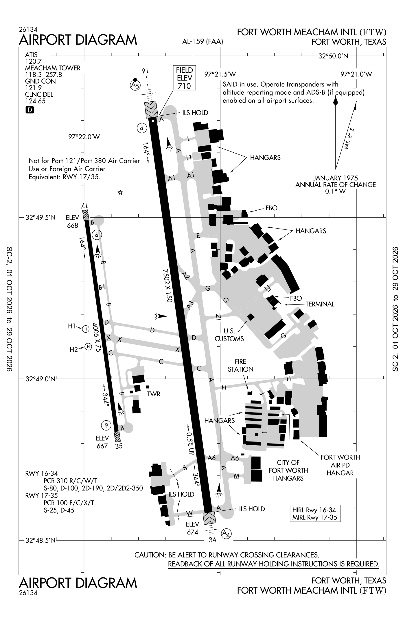
For understanding the field, not for navigation.
| Runway | Length × width | Surface | Lights |
|---|---|---|---|
| 16/34 | 7,502 × 150 ft | Concrete, good | High-intensity lights |
| 17/35 | 4,005 × 75 ft | Asphalt, excellent | Medium-intensity lights |
| H1 | 35 × 35 ft | Concrete, good | |
| H2 | 35 × 35 ft | Concrete, good |
- Runway 16: ILS with DME, PAPI, four lights on the right, medium-intensity approach lights with runway alignment lights (MALSR), pole 31 ft high 1,450 ft from the end
- Runway 34: ILS with DME, medium-intensity approach lights (MALS), right-hand traffic pattern, 7,306 ft available for landing
- Runway 17: PAPI, two lights on the left, right-hand traffic pattern, berm 39 ft high 1,361 ft from the end
- Runway 35: PAPI, two lights on the left
Radio frequencies
| ATIS (recorded airport information) | 120.7 | Meacham |
| Clearance delivery | 124.65 | Meacham |
| Ground | 121.9 | Meacham |
| Tower | 118.3 | Meacham |
| Approach and departure · Departure procedure (BOTCH) · Dallas Area Dp North; South | 118.1 | Meacham |
| Approach and departure · Departure procedure (BOTCH) · Dallas Area Dp South; North | 135.975 | Meacham |
| Emergency | 121.5 | Meacham |
| Ftw and vot | 108.2 | |
| Sasie and star · Truuk Rnav Star | 124.3 | Meacham |
| Dodje and star · Reeko and star | 125.2 | Meacham |
| Likes and star · Motza and star · Wesat and star South; North | 125.8 | Meacham |
| Dodje and star | 125.9 | Meacham |
Automated weather (ASOS), by phone 817-740-3346.
Based aircraft as counted for the FAA, fiscal year 2024
Takeoffs and landings a year about 216,739, the FAA's fiscal year 2024 (October 2023 to September 2024)
Local flights stay in the traffic pattern or nearby, often practice; travelling flights arrive from or leave for somewhere else. Counts at airports without a tower are the FAA's estimates.
Wind map live wind over the area, from Windy.com
Colours show wind speed, the moving lines its direction; drag the time bar for the coming days. Map and forecast by Windy.com.
Aircraft registered in Fort Worth from the FAA register
1,876 aircraft are registered to owners in Fort Worth, Texas: 993 airliners and large jets, 531 piston singles, 145 helicopters, 64 business jets, 53 piston twins. Not every one of them is based at this airport; the based-aircraft count above is the FAA's figure for this airport alone.
Companies and organisations in town with two or more aircraft:
Individuals are counted, never named. All aircraft registered in Texas.
Accidents and incidents at or near this airport NTSB records · 40 since 1982, 2 fatal
Cases the NTSB recorded with this as the nearest airport, newest first. Each opens the full report in plain English.
Nearby within 30 nautical miles
The FAA's remarks as written in the airport file
- Pattern altitude - runway 17/35 R/west 1300(590) above ground level, F/west 1500(790) above ground level, runway 16/34 1500(790) above ground level, jets 2000(1290) above ground level.
- Runway 17/35 not available for part 121/PART 380 operations with schedule passenger carrying operations more than 9 passenger seats and unscheduled passenger carrying operations more than 30 passenger seats.
- Birds on and in the vicinity of airport.
- Taxiways B, B1, C, and D west of runway 16/34, M east of taxiway a, taxiways H, J, L, L1, south, west, and taxiway G southeast 650 feet closed to aircraft with more than 30 psgr seats.
- Runway 17/35 designed for aircraft with wingspan of 49 feet or less. Taxiways B and B1 designed for aircraft with wingspan of less than 79 feet. Runway 16/34 and taxiways a, A1, and M designed for aircraft with wingspan less than 171 feet. All other taxiways designed for aircraft with wingspan of less than 118 feet.
- H1 and H2 helipads are vmc daylight use only; NON-MOVEMENT area.
- Marked U.S. customs parking southeast of txl G and txl north intersection.
- Helo skidding operations prohibited on runway 17/35. If skidding is required, coord with the control tower to use taxiway B.
- Airport fees for use of customs services will be colld imt upon landing by city of Fort Worth airport operations personnel.
- Runway 17/35 led light can appr brgtr than runway 16/34; ensure cor runway alnmt.
- Rescue and firefighting (ARFF) index B available all users with 24 hour prior permission required.
Facts from the FAA's airport file effective October 1, 2026, written out in plain English; weather from the National Weather Service's aviation weather service; registered aircraft from the FAA register as of October 5, 2026; accidents from the NTSB's public database. Owners are shown only when they are an organisation; no person is named. Check the official sources before a flight: this page is for understanding an airport, not for planning one.