
Hill Air Force Base
HIF · KHIF · Ogden, Utah · Davis County · map
Hill Air Force Base is a private airport owned by Usaf, 6 miles south of Ogden, Utah, 4,789 feet above sea level. Its one runway, 14/32, is 13,500 feet of partially concrete. It has a control tower and fuel (Jet A with additives).
Private use: permission from the owner is required before landing here.
Weather right now KHIF · observed 3:55 pm MDT (21:55 UTC), 57 minutes ago
VFR good flying weather
- Wind from the southwest (230°) at 3 knots
- Visibility 10 miles or more
- Temperature 79°F (26°C), dew point 37°F (3°C)
- Altimeter 30.18 inHg
The forecast issued Tue 3:00 pm MDT (21:00 UTC), good until Wed 9:00 pm MDT (03:00 UTC)
- From Tue 3:00 pm MDT (21:00 UTC): wind light and variable, a few clouds at 10,000 feet, scattered clouds at 18,000 feet
- Changing between Tue 7:00 pm MDT (01:00 UTC) and 8:00 pm MDT (02:00 UTC) to: wind from the east at 12 knots, gusting to 20, a few clouds at 12,000 feet
- Changing between Wed 11:00 am MDT (17:00 UTC) and 12:00 pm MDT (18:00 UTC) to: wind from the south at 7 knots, a few clouds at 18,000 feet
The codes as issued (METAR and TAF)
METAR KHIF 062155Z AUTO 23003KT 10SM CLR 26/03 A3018 RMK AO2 SLP163 T02620028
TAF KHIF 062100Z 0621/0803 VRB06KT 9999 FEW100 SCT180 QNH3015INS BECMG 0701/0702 08012G20KT 9999 FEW120 QNH3018INS BECMG 0717/0718 19007KT 9999 FEW180 QNH3020INS TX28/0622Z TN15/0614Z
From the National Weather Service's aviation weather service, refreshed every few minutes; times are local to the airport with UTC in brackets. For a flight, get your briefing from Flight Service or an approved provider.
The airport
- Codes
- FAA HIF · ICAO KHIF
- Kind
- Airport · private use, permission required · owned by the Air Force
- Owner
- Usaf
- Elevation
- 4,789 feet above sea level
- Control tower
- A control tower with radar approach control · operates 1500-0700z++ mon-sat; 1600-0000z++ sat-sun. closed fed holidays.
- Attended
- Monday to Saturday, 3:00 pm to 0700z++; weekends, 4:00 pm to 0000z++
- Lights
- runway lights sunset to sunrise; beacon sunset to sunrise
- Fuel
- Jet A with additives
- Repairs
- airframe: major repairs; engine: major repairs
- On the chart
- Salt Lake City sectional
- Magnetic variation
- 14E
- In the FAA's files since
- August 1943
Runway
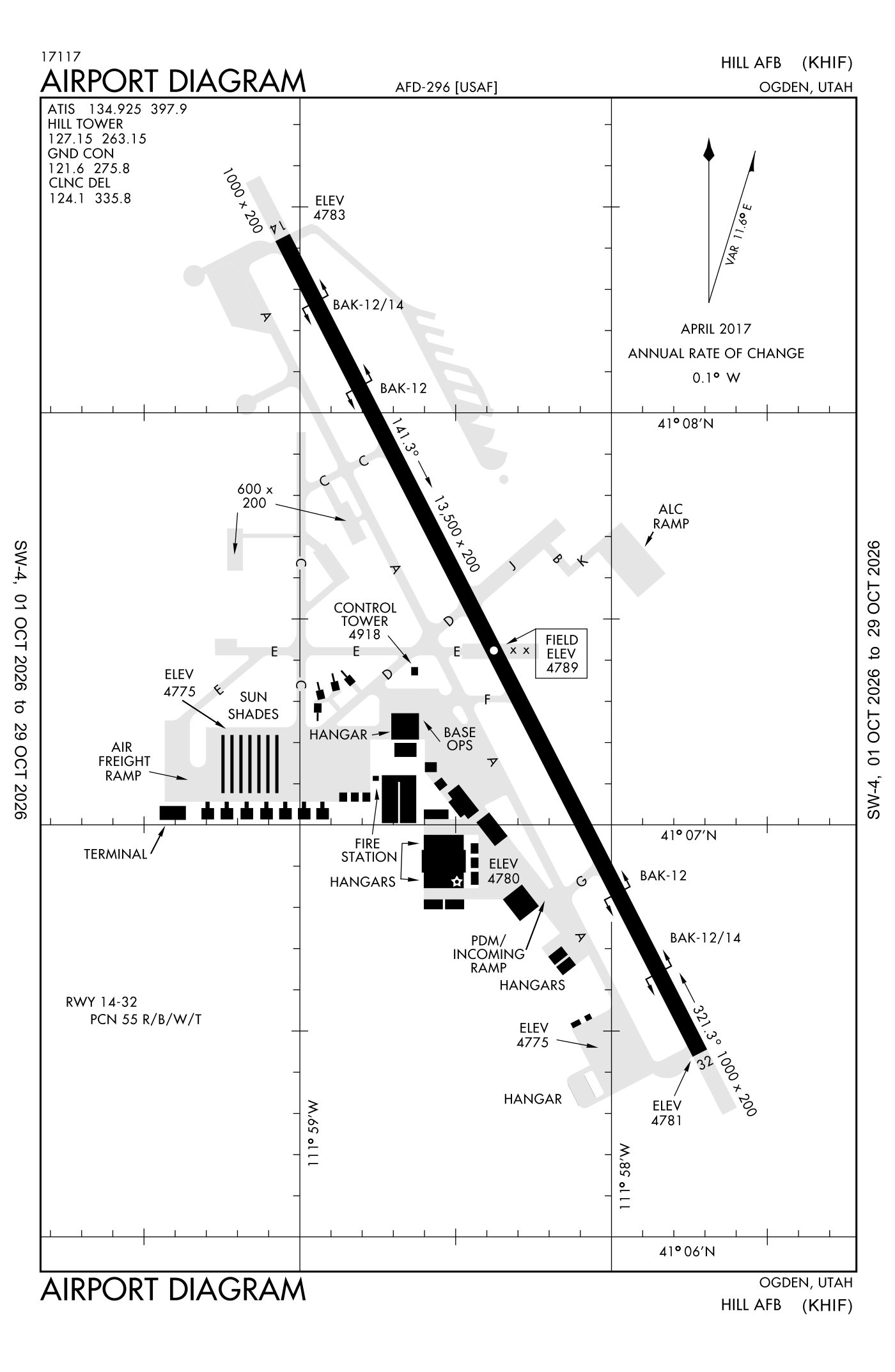
For understanding the field, not for navigation.
| Runway | Length × width | Surface | Lights |
|---|---|---|---|
| 14/32 | 13,500 × 200 ft | Partially concrete, good | High-intensity lights |
- Runway 14: ILS, PAPI, four lights on the left, approach lights with sequenced flashers (ALSF-2)
- Runway 32: PAPI, four lights on the left, omnidirectional approach lights (ODALS), right-hand traffic pattern
Radio frequencies
| ATIS (recorded airport information) | 134.925 | Hill |
| Clearance delivery | 124.1 | Hill |
| Ground | 121.6 | Hill |
| Tower | 127.15 | Hill |
| Approach and departure North | 118.45 | |
| Approach and departure | 121.1 | Hill |
| Approach and departure South | 134.1 | |
| Emergency | 121.5 | Hill |
| Pre-taxi clearance | 134.75 | Hill |
| Pre-taxi clearance | 139.3 | Hill |
Aircraft registered in Ogden from the FAA register
111 aircraft are registered to owners in Ogden, Utah: 71 piston singles, 14 turboprops, 13 business jets, 5 gliders, 4 piston twins. Not every one of them is based at this airport; the based-aircraft count above is the FAA's figure for this airport alone.
Companies and organisations in town with two or more aircraft:
Individuals are counted, never named. All aircraft registered in Utah.
Accidents and incidents at or near this airport NTSB records · 2 since 1982, 0 fatal
Cases the NTSB recorded with this as the nearest airport, newest first. Each opens the full report in plain English.
Nearby within 30 nautical miles
The FAA's remarks as written in the airport file
- BAK-14 BAK-12B(B) (1250 feet) hook BAK-12B(B) (2574 feet)
- Hook BAK-12B(B) (2584 feet) BAK-14 BAK-12B(B) (1250 feet)
- Non-standard length 2422 feet.
- Non-standard 1450 feet. Tallest light 16 feet 9 in.
- First 2800 feet runway 14 and first 1500 feet runway 32 grooved concrete; mid 9200 feet grooved asphalt.
- A-GEAR: BAK-12B departure end active runway in raised posn; 15 MIN/30 minimum NON-DUTY hour PN rqr to erect on approach end of act runway; BAK-12B/14 O/R from tower.
- Jasu: 4(MA-1A) 7(A/M32A-86) 5(AM32A-60).
- Fluid: SP presair lhox lox DE-ICE oil -O-128-133-148-156; JOAP-4 hour PN rqr dsn 777-1861.
- Transient alert: DE-ICING available.
- Ctn: hvy traffic on approach and departure; exp turb approach and landing runway 14 durg med - HI surface winds; wind velocity may vary from approach to departure end of runway.
- Caution: do not mistake Ogden airport 4.5 NM north for Hill Afb. Aircraft departure should not exceed 6300' until past departure end of runway to avoid overhead traffic pattern.
- Traffic pattern: rectangular 6300', overhead 6800', maintenance 6800' until turning base leg. Usaf (AF, ang, afrc) ftr aircraft exp reduced runway separation day, VFR-3000' between similar aircraft, 6000' between dissimilar aircraft. Variations exist for different type operates.
Facts from the FAA's airport file effective October 1, 2026, written out in plain English; weather from the National Weather Service's aviation weather service; registered aircraft from the FAA register as of October 5, 2026; accidents from the NTSB's public database. Owners are shown only when they are an organisation; no person is named. Check the official sources before a flight: this page is for understanding an airport, not for planning one.