
March Arb Airport
RIV · KRIV · Riverside, California · Riverside County · map
March Arb Airport is a public-use airport owned by United States Air Force, 6 miles southeast of Riverside, California, 1,536 feet above sea level. It has 2 runways; the longest, 14/32, is 13,302 feet of concrete. It has a control tower, fuel (100LL avgas, Jet A, Jet A with additives) and 2 based aircraft. About 782 passengers boarded flights here in the FAA's fiscal year 2024.
Weather right now KRIV · observed 3:55 pm PDT (22:55 UTC), 36 minutes ago
VFR good flying weather
- Wind from the south-southwest (200°) at 6 knots
- Visibility 10 miles or more
- Temperature 100°F (38°C), dew point 40°F (5°C)
- Altimeter 29.82 inHg
The forecast issued Tue 1:03 pm PDT (20:03 UTC), good until Wed 7:00 pm PDT (02:00 UTC)
- From Tue 1:00 pm PDT (20:00 UTC): wind light and variable, a few clouds at 12,000 feet
- Changing between Tue 2:00 pm PDT (21:00 UTC) and 3:00 pm PDT (22:00 UTC) to: wind from the northwest at 9 knots, a few clouds at 12,000 feet
- At times between Tue 3:00 pm PDT (22:00 UTC) and 6:00 pm PDT (01:00 UTC): wind from the northwest at 10 knots, gusting to 15
- Changing between Tue 7:00 pm PDT (02:00 UTC) and 8:00 pm PDT (03:00 UTC) to: wind light and variable, clear skies
- Changing between Wed 2:00 am PDT (09:00 UTC) and 3:00 am PDT (10:00 UTC) to: wind from the south-southeast at 4 knots, clear skies
- Changing between Wed 10:00 am PDT (17:00 UTC) and 11:00 am PDT (18:00 UTC) to: wind from the west-northwest at 4 knots, clear skies
- Changing between Wed 1:00 pm PDT (20:00 UTC) and 2:00 pm PDT (21:00 UTC) to: wind from the west-northwest at 9 knots, clear skies
- At times between Wed 2:00 pm PDT (21:00 UTC) and 7:00 pm PDT (02:00 UTC): wind from the northwest at 12 knots, gusting to 18
The codes as issued (METAR and TAF)
METAR KRIV 062255Z AUTO 20006KT 10SM CLR 38/05 A2982 RMK AO2 SLP079 T03780046
TAF KRIV 062003Z 0620/0802 VRB06KT 9999 FEW120 QNH2984INS BECMG 0621/0622 32009KT 9999 FEW120 510006 QNH2981INS TEMPO 0622/0701 32010G15KT BECMG 0702/0703 VRB04KT 9999 SKC QNH2985INS BECMG 0709/0710 15004KT 9999 SKC QNH2987INS BECMG 0717/0718 30004KT 9999 SKC QNH2984INS BECMG 0720/0721 30009KT 9999 SKC 510006 QNH2981INS TEMPO 0721/0802 31012G18KT TX38/0622Z TN19/0714Z
From the National Weather Service's aviation weather service, refreshed every few minutes; times are local to the airport with UTC in brackets. For a flight, get your briefing from Flight Service or an approved provider.
The airport
- Codes
- FAA RIV · ICAO KRIV
- Kind
- Airport · open to the public · owned by the Air Force
- Owner
- United States Air Force
- Elevation
- 1,536 feet above sea level
- Control tower
- A control tower with radar approach control · around the clock
- Attended
- every day, 7:00 am to 11:00 pm
- Lights
- beacon sunset to sunrise
- Fuel
- 100LL avgas, Jet A, Jet A with additives
- Repairs
- airframe: major repairs; engine: major repairs
- Notes
- customs available
- On the chart
- Los Angeles sectional
- Magnetic variation
- 14E
- In the FAA's files since
- May 1941
Runways 2
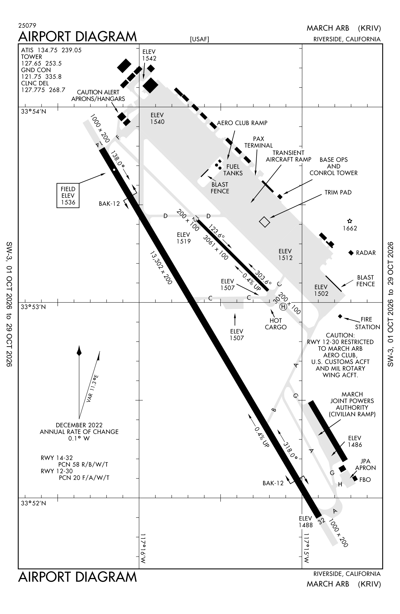
For understanding the field, not for navigation.
| Runway | Length × width | Surface | Lights |
|---|---|---|---|
| 14/32 | 13,302 × 200 ft | Concrete, good | High-intensity lights |
| 12/30 | 3,061 × 100 ft | Asphalt, poor |
- Runway 14: PAPI, four lights on the left
- Runway 32: ILS, PAPI, four lights on the left, approach lights with sequenced flashers (ALSF-1)
Radio frequencies
| ATIS (recorded airport information) | 134.75 | March |
| Ground | 121.75 | March |
| Tower | 127.65 | March |
| Approach (secondary) Departure (secondary) · Class C airspace | 119.25 | March |
| Approach and departure · Class C airspace | 133.5 | March |
| Approach and departure | 134.0 | March |
| Emergency | 121.5 | March |
| Comd and post | 138.45 | March |
Based aircraft as counted for the FAA, fiscal year 2024
Takeoffs and landings a year
No operations count is published for this airport.
Wind map live wind over the area, from Windy.com
Colours show wind speed, the moving lines its direction; drag the time bar for the coming days. Map and forecast by Windy.com.
Aircraft registered in Riverside from the FAA register
210 aircraft are registered to owners in Riverside, California: 177 piston singles, 12 piston twins, 8 business jets, 5 helicopters, 3 turboprops. Not every one of them is based at this airport; the based-aircraft count above is the FAA's figure for this airport alone.
Companies and organisations in town with two or more aircraft:
Individuals are counted, never named. All aircraft registered in California.
Accidents and incidents at or near this airport NTSB records · 7 since 1982, 1 fatal
Cases the NTSB recorded with this as the nearest airport, newest first. Each opens the full report in plain English.
Nearby within 30 nautical miles
The FAA's remarks as written in the airport file
- Caution: non-standard runway MRK-LANDING zone (LZ) mark (3500X90 painted on runway 32 for base asgn C17 aircraft only).
- Traffic pattern - rectangular 3000', overhead 3500'.
- Operates H24; operations from 0700-1500Z++ rqr 452 OG/CC apvl, except for kriv based alert msn.
- TYPE-H BAK-12B(B) (1500')
- TYPE-H BAK-12B(B) (1500')
- Full service available at the FBO (fixed-base operator); SELF-SERVE unavailable.
- Runway 12/30 closed to PUBLIC-USE only.
- Runway 12/30 is a sry runway, used for military operations and mntnd by the military. It is in very poor condition.
- Caution: extv glider, skydiving, balloonist and ultralight act at perris airport, 7 NM south of March.
- Caution: heavy military flight training.
- Joint use airport - owned and operated by U.S. air FORCE/ no civil touch and go operations or maneuvers.
- Airfield use agreement with civil airport authorized (March inland port airport authorized) military, civil commercial and general aviation(general aviation) uses.
Facts from the FAA's airport file effective October 1, 2026, written out in plain English; weather from the National Weather Service's aviation weather service; registered aircraft from the FAA register as of October 5, 2026; accidents from the NTSB's public database. Owners are shown only when they are an organisation; no person is named. Check the official sources before a flight: this page is for understanding an airport, not for planning one.