
Fernando Luis Ribas Dominicci Airport
SIG · TJIG · San Juan, Puerto Rico · --Puerto Rico County · map
Fernando Luis Ribas Dominicci Airport is a public-use airport owned by Puerto Rico Ports Authority in San Juan, Puerto Rico, 10 feet above sea level. Its one runway, 09/27, is 5,539 feet of asphalt. It has a control tower, fuel (100 octane avgas, Jet A) and about 188 based aircraft. The FAA counts about 97,748 takeoffs and landings a year. About 14,274 passengers boarded flights here in the FAA's fiscal year 2024.
Weather right now TJIG · observed 6:50 pm AST (22:50 UTC), 3 minutes ago
VFR good flying weather
- Wind from the east-southeast (110°) at 7 knots
- Visibility 10 miles or more
- Sky: scattered clouds at 2,500 feet, a broken layer at 6,000 feet, a broken layer at 8,000 feet
- Temperature 82°F (28°C), dew point 75°F (24°C)
- Altimeter 29.89 inHg
No terminal forecast is issued for this station. The nearest forecast is usually at the closest larger airport.
The codes as issued (METAR and TAF)
METAR TJIG 062250Z 11007KT 10SM SCT025 BKN060 BKN080 28/24 A2989 RMK ATIS M
From the National Weather Service's aviation weather service, refreshed every few minutes; times are local to the airport with UTC in brackets. For a flight, get your briefing from Flight Service or an approved provider.
The airport
- Codes
- FAA SIG · ICAO TJIG
- Kind
- Airport · open to the public · publicly owned
- Owner
- Puerto Rico Ports Authority
- Elevation
- 10 feet above sea level
- Pattern altitude
- 990 feet above the airport
- Control tower
- A control tower · 7:00 am to 7:00 pm
- Attended
- every day, 6:00 am to 7:30 pm
- Lights
- runway lights see the remarks below; beacon sunset to sunrise
- Fuel
- 100 octane avgas, Jet A
- Repairs
- airframe: major repairs; engine: major repairs
- Parking
- tiedown
- Notes
- landing fee
- On the chart
- Puerto Rico-Virgin Islands sectional
- Magnetic variation
- 12W
- In the FAA's files since
- September 1947
Runway
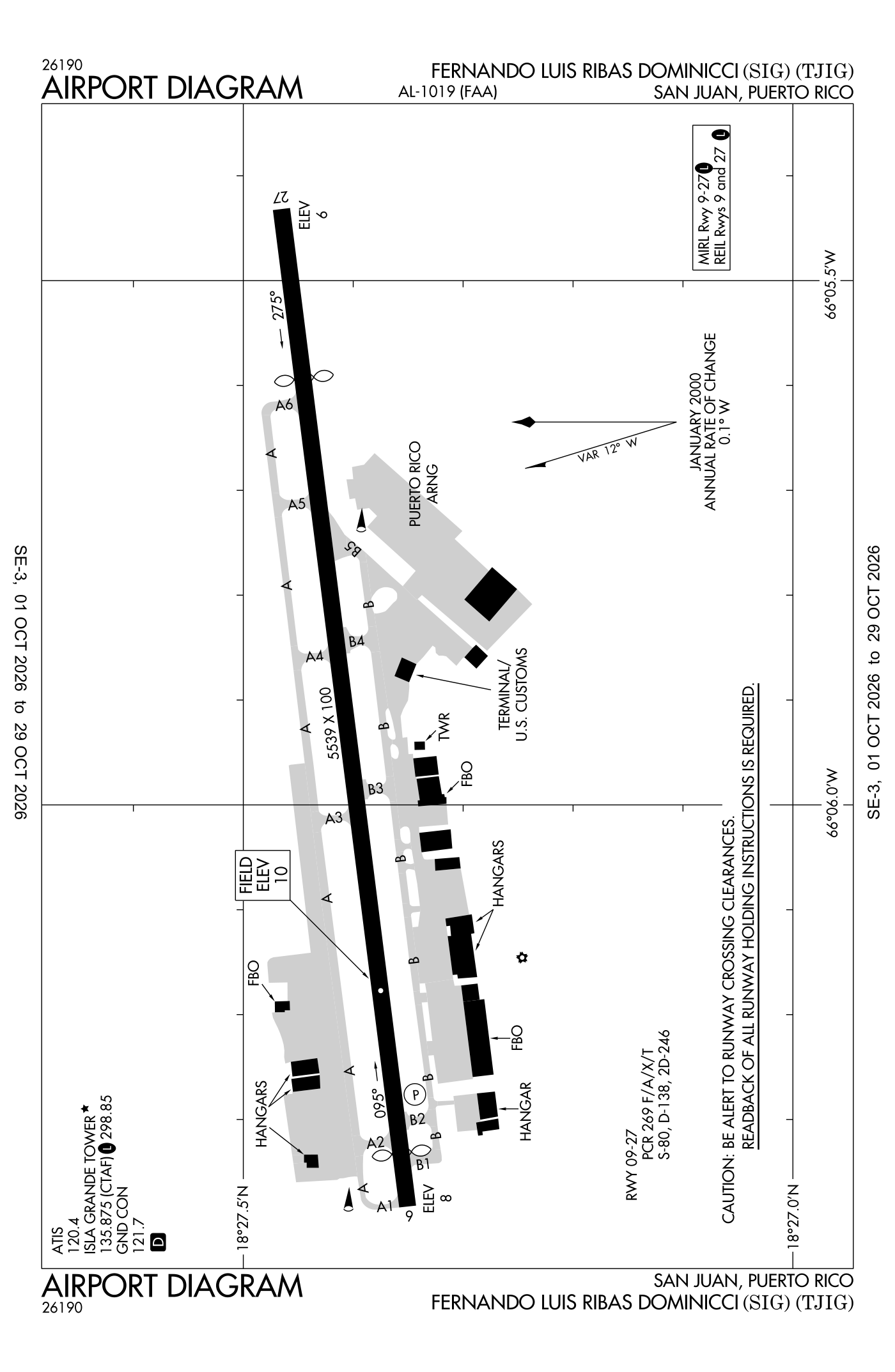
For understanding the field, not for navigation.
| Runway | Length × width | Surface | Lights |
|---|---|---|---|
| 09/27 | 5,539 × 100 ft | Asphalt, good | Medium-intensity lights |
- Runway 09: PAPI, two lights on the right, threshold displaced 298 ft, 5,126 ft available for landing
- Runway 27: right-hand traffic pattern, threshold displaced 940 ft, 4,299 ft available for landing, road 15 ft high 201 ft from the end
Radio frequencies
| Common traffic advisory (CTAF) · Tower | 135.875 | Isla Grande |
| ATIS (recorded airport information) | 120.4 | Isla Grande |
| Ground | 121.7 | Isla Grande |
| Approach and departure West and southwest | 119.4 | Isla Grande |
| Approach and departure North and east | 120.9 | Isla Grande |
| Arng and operations | 139.1 | Isla Grande |
Based aircraft as counted for the FAA, fiscal year 2024
Takeoffs and landings a year about 97,748, the FAA's fiscal year 2024 (October 2023 to September 2024)
Local flights stay in the traffic pattern or nearby, often practice; travelling flights arrive from or leave for somewhere else. Counts at airports without a tower are the FAA's estimates.
Wind map live wind over the area, from Windy.com
Colours show wind speed, the moving lines its direction; drag the time bar for the coming days. Map and forecast by Windy.com.
Aircraft registered in San Juan from the FAA register
171 aircraft are registered to owners in San Juan, Puerto Rico: 76 piston singles, 40 piston twins, 27 helicopters, 14 business jets, 11 turboprops. Not every one of them is based at this airport; the based-aircraft count above is the FAA's figure for this airport alone.
Companies and organisations in town with two or more aircraft:
Individuals are counted, never named. All aircraft registered in Puerto Rico.
Accidents and incidents at or near this airport NTSB records · 30 since 1982, 6 fatal
Cases the NTSB recorded with this as the nearest airport, newest first. Each opens the full report in plain English.
Nearby within 30 nautical miles
The FAA's remarks as written in the airport file
- Aftr tower hours activate medium-intensity runway lightss runway 9/27 - the common traffic frequency.
- Amgr ext 3331, operations ext 3332.
- 15 feet road, 0-199 feet dstc, 80 feet R, 210 feet L.
- Helicopters occasionally use RT traffic runway 9 when dir by the control tower.
- Occasional 90 feet boats, 0-200 feet dstc, 220 feet R.
- Fee for all aircraft.
- When the control tower closed straight in pattern not authorized.
- Runway 9/27 aircraft with wingspan over 79 feet, airport does not meet design standard for wing clnc.
- Index A-1 rescue and firefighting (ARFF) equipment avail 6:00 am to 7:30 pm.
- San Juan bay cruise ship maneuvering area. Tall vessel obstruction on final approach to runway 9 or departing runway 27.
- Runway 27 approach end, runway 9 departure end, tall vessels at marina.
- 346 feet high lighted cranes, 0.5 MI southeast aer 09. Exercise ctn using rite traffic pattern for runway 09.
Facts from the FAA's airport file effective October 1, 2026, written out in plain English; weather from the National Weather Service's aviation weather service; registered aircraft from the FAA register as of October 5, 2026; accidents from the NTSB's public database. Owners are shown only when they are an organisation; no person is named. Check the official sources before a flight: this page is for understanding an airport, not for planning one.