
Dupage Airport
DPA · KDPA · Chicago/West Chicago, Illinois · Du Page County · map
Dupage Airport is a public-use airport, 29 miles west of Chicago/West Chicago, Illinois, 758 feet above sea level. It has 4 runways; the longest, 02L/20R, is 7,571 feet of concrete. It has a control tower, fuel (100LL avgas, Jet A) and about 236 general-aviation aircraft based on the field by the FAA's count. The FAA counts about 165,371 takeoffs and landings a year. About 102 passengers boarded flights here in the FAA's fiscal year 2024.
Quick answers answers refresh every morning
What is the airport code for Dupage Airport?
Its FAA code is DPA, and its ICAO code is KDPA.
Where is Dupage Airport?
It is 29 miles west of Chicago/West Chicago, Illinois, 758 feet above sea level.
How long is the longest runway at Dupage Airport?
The longest of its 4 runways, 02L/20R, is 7,571 feet long.
Does Dupage Airport have a control tower?
Yes, it has a control tower.
What fuel can you buy at Dupage Airport?
The FAA's airport file lists 100LL avgas, Jet A.
Where can you fly nonstop from Dupage Airport?
Airline flights go to 8 airports, the busiest of them Chicago Executive, Teterboro, Angouleme, Talladega Municipal, Bologna. Every route
Are there flight schools at Dupage Airport?
8 flight schools, flying clubs or college flight programmes are based within about 15 miles of it, including Travel Express Aviation LLC and Avel Aircraft INC. Compare them
Where are the nearest FAA examiners to Dupage Airport?
23 pilot examiners and 33 aviation medical examiners work within 50 nautical miles. See them by name
Weather and planning now, the forecast, warnings, pilot reports, winds aloft, restrictions
Fetching the weather now, the forecast, the warnings in force, pilot reports and the winds aloft for Dupage Airport…
Wind map live wind over the area, from Windy.com
Colours show wind speed, the moving lines its direction; drag the time bar for the coming days. Map and forecast by Windy.com.
The airport facts, runways, radio, fuel and services, the FAA's remarks
The airport
- Codes
- FAA DPA · ICAO KDPA
- Kind
- Airport · open to the public · publicly owned
- Elevation
- 758 feet above sea level
- Control tower
- A control tower · around the clock
- Attended
- around the clock
- Lights
- runway lights see the remarks below
- Fuel and services
- 100LL avgas, Jet A; the services card below
- On the chart
- Chicago sectional
- Magnetic variation
- 1W
- In the FAA's files since
- March 1943
Runways 4
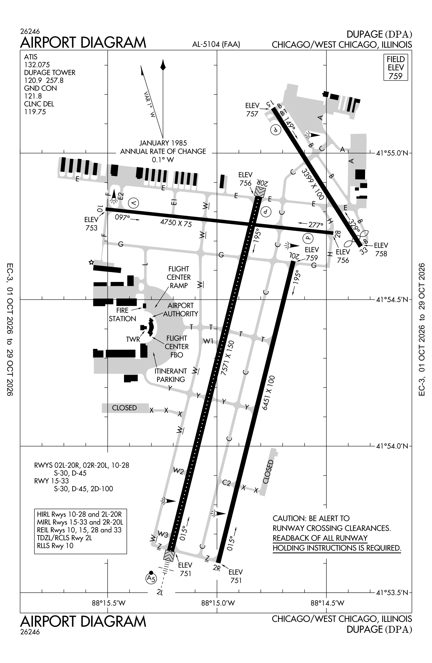
For understanding the field, not for navigation.
| Runway | Length × width | Surface | Lights |
|---|---|---|---|
| 02L/20R | 7,571 × 150 ft | Concrete, good | High-intensity lights |
| 02R/20L | 6,451 × 100 ft | Concrete, good | Medium-intensity lights |
| 10/28 | 4,750 × 75 ft | Asphalt, good | High-intensity lights |
| 15/33 | 3,399 × 100 ft | Asphalt, good | Medium-intensity lights |
- Runway 02L: ILS, medium-intensity approach lights with runway alignment lights (MALSR)
- Runway 20R: PAPI, four lights on the left
- Runway 02R: right-hand traffic pattern
- Runway 10: ILS, VASI, four boxes on the left, runway lead-in lights, building 34 ft high 1,743 ft from the end
- Runway 28: PAPI, four lights on the left
- Runway 15: PAPI, four lights on the right, tree 91 ft high 1,750 ft from the end
- Runway 33: threshold displaced 190 ft, tree 55 ft high 893 ft from the end
Radio frequencies
| UNICOM | 122.95 | |
| ATIS (recorded airport information) | 132.075 | Dupage |
| Clearance delivery | 119.75 | Dupage |
| Ground | 121.8 | Dupage |
| Tower | 120.9 | Dupage |
| Tower (secondary) | 124.5 | Dupage |
| Approach and departure | 133.5 | Dupage |
| Dupage and rco | 122.3 | Dupage |
Automated weather (ASOS), by phone 630-587-3668.
Fuel and services as reported to the FAA
- Fuel
- 100LL avgas, Jet A
- Repairs
- airframe and engine: major repairs
- Parking
- hangars, tie-downs
- Oxygen
- bottled oxygen (high- and low-pressure), bulk oxygen (high- and low-pressure)
- Also here
- air freight, avionics, cargo handling, charter flights, flight instruction, aircraft rental, aircraft sales
Other fields with jet fuel nearby: Schaumburg Regional (8 nm northeast), Aurora Municipal (13 nm southwest), Bolingbrook'S Clow International (14 nm southeast).
The FAA's file records what is sold and done at the field, as the airport manager reports it, not who sells it or the price; fuel sellers (FBOs) are not named in any public file. Airports selling jet fuel in Illinois · avgas.
The FAA's remarks as written in the airport file, spelled out
- Deer, coyote, birds and migratory waterfowl on and in the vicinity of airport.
- ATC-CTL
- 100LL self ser available 24HR with credit card.
- +13 feet road 199 feet from runway end 125 feet R.
- Unusable beyond 5 degrees right and left of centerline.
- Approach ratio is 20:1 to displaced thld.
- Aircraft on short final to runway 15 are not vsb from the control tower due to trees.
- Rescue and firefighting (ARFF) index B prior permission required
- U.S. customs service available prior permission required.
- Int departure runway 20R at taxiway G has 6141'.
Flights and activity in the air now, the airlines, based aircraft, takeoffs and landings
Activity now checking the volunteer receiver network…
Within ten miles
- Looking…
Arrivals and departures, last hour
- Looking…
From the volunteer receiver network, a few minutes behind at most; aircraft whose owners asked the FAA not to be displayed are left out; no person is named. Open the live map here.
Scheduled and charter flights from here the DOT's airline reports · August 2025 to July 2026
Airlines reported 24 departures from DPA in those twelve months, carrying 65 passengers in 240 seats (27% filled), to 18 destinations (10 abroad) on 7 airlines.
| Where to | Flights | Passengers | Airlines |
|---|---|---|---|
| Dupage → Chicago Executive DPA–PWK | 5 | 3 | Jet Aviation Flight... |
| Dupage → Teterboro DPA–TEB | 3 | 0 | Air Hamburg..., Jet Aviation Flight... |
| Dupage → Angouleme DPA–ANG | 1 | 14 | VistaJet Limited |
| Dupage → Talladega Municipal DPA–ASN | 1 | 0 | Gulf And Caribbean Cargo |
| Dupage → Bologna DPA–BLQ | 1 | 2 | VistaJet Limited |
| Dupage → Faro DPA–FAO | 1 | 2 | VistaJet Limited |
| Dupage → Florence DPA–FLR | 1 | 4 | FAI rent-a-jet AG |
| Dupage → Indianapolis International DPA–IND | 1 | 0 | CFM Inc d/b/a Contour... |
All 18 destinations, the airlines and the aircraft, month by month
From the Bureau of Transportation Statistics' T-100 table: every segment an airline reported flying, three months in arrears. Private, business and training flights are not in it; the live picture is in the activity card.
Based aircraft as counted for the FAA, fiscal year 2024
Based aircraft, as a table
| aircraft | |
|---|---|
| single-engine | 164 |
| multi-engine | 23 |
| jets | 45 |
| helicopters | 4 |
The FAA's count is the general-aviation aircraft kept on the field (singles, twins, business jets, helicopters) from its Terminal Area Forecast, the latest year with an actual count; airline fleets are never counted as based anywhere, so a big airline airport shows a small number. The register section below shows how many aircraft are registered to owners in town, a different measure again.
Takeoffs and landings a year about 165,371, the FAA's fiscal year 2024 (October 2023 to September 2024)
Takeoffs and landings, as a table
| a year | |
|---|---|
| airline | 22 |
| air taxi and commuter | 13,253 |
| general aviation, travelling | 63,614 |
| general aviation, local | 88,061 |
| military | 421 |
Local flights stay in the traffic pattern or nearby, often practice; travelling flights arrive from or leave for somewhere else. Counts at airports without a tower are the FAA's estimates. How this compares nationally: Airports by the numbers.
Who flies and works here aircraft registered in town, the companies, the examiners nearby
Aircraft registered in Chicago/West Chicago from the FAA register
No aircraft on the register list Chicago/West Chicago, IL as the owner's town.
Who works here from the FAA's certificate lists and the register
Flight schools, flying clubs and college flight programmes based within about 15 miles:
- Travel Express Aviation LLC 4 aircraft · West Chicago, 2 miles away Travel Express Aviation is a full-service aviation business based at DuPage Airport in West Chicago, Illinois.
- Avel Aircraft INC 3 aircraft · West Chicago, 2 miles away Avel Flight School is an FAA Part 141 approved flight training school based at DuPage Airport in West Chicago, Illinois.
- International Flying Club INC 2 aircraft · Winfield, 5 miles away International Flying Club is a non-profit flying club based at DuPage Airport in West Chicago, Illinois.
- Vagabond Flying Association 2 aircraft · Winfield, 5 miles away The Vagabond Flying Association is a member-owned flying club based at DuPage Airport in West Chicago, Illinois.
- J3 Flying Club INC 1 aircraft · Bartlett, 5 miles away
- Fox Flying Club INC 3 aircraft · Wheaton, 8 miles away Fox Flying Club is a member-owned non-profit flying club based at DuPage Airport near Chicago.
- Business Mens Flying Club INC 3 aircraft · Naperville, 12 miles away
- Ja Flight Services LLC 8 aircraft · Sugar Grove, 14 miles away JA Flight Training is a flight school in Sugar Grove, Illinois that offers pilot training from private pilot through commercial and instructor ratings.
Companies in the same town as this airport, and schools within about 15 miles of it (each placed at the main public airport of its town, or at the town's centre); not every one of them works from this field. All operators · all repair stations · all flight schools · all FBOs.
Examiners and inspectors nearby designated by the FAA · within 50 nautical miles
23 pilot examiners (the FAA's designated pilot examiners, who give the practical tests for pilot certificates) are based within 50 nautical miles: 23 for private pilot, 18 for commercial and instrument, 7 for airline transport pilot, 14 for flight instructor, 3 for sport pilot, 2 for type ratings; 22 for airplanes, 9 for multi-engine airplanes, 1 for seaplanes, 2 for helicopters, 1 for gliders, 1 for balloons. Also nearby: 5 sport aviation examiners, 33 aviation medical examiners, 8 mechanic examiners, 1 airworthiness representative (maintenance), 8 airworthiness representatives (manufacturing), 5 engineering representatives, 2 parachute rigger examiners, 2 aircraft dispatcher examiners, 3 training center examiners, 2 administrative pilot examiners.
- Logan Arlis private pilot, commercial and instrument, instructor renewals, military competency, ground instructor, foreign pilot certificates; airplanes · Dupage Airport · West Chicago, IL (2 nm) · (630) 327-8074 · [email protected]
- Kevin Carlyle Lindsay private pilot, commercial and instrument, flight instructor, instrument instructor, instructor renewals, military competency, ground instructor; airplanes · Naperville, IL (7 nm) · (708) 655-4901 · [email protected]
- Ronald Neal Ridenour private pilot, flight instructor, instrument instructor, commercial pilot, instructor renewals, ground instructor, foreign pilot certificates; gliders · Naperville, IL (10 nm) · (630) 854-9456 · [email protected]
- Jay Christopher Rud private pilot, instructor renewals, military competency, ground instructor; airplanes · J.A. Flight Training · Aurora, IL (12 nm) · (815) 557-5221 · [email protected]
- Gregory Mark Wilson private pilot, commercial and instrument, instructor renewals, military competency, ground instructor, foreign pilot certificates; airplanes · Oswego, IL (15 nm) · (815) 474-0202 · [email protected]
- Adam Milnes private pilot; airplanes · Greater Chicago FSDO · Des Plaines, IL (16 nm) · (708) 819-5040 · [email protected]
- Devin John Macdonald private pilot, commercial and instrument, airline transport pilot, flight instructor, type ratings, private pilot (proficiency), instructor renewals, ground instructor, foreign pilot certificates; airplanes, multi-engine airplanes · Chicago, IL (16 nm) · (847) 778-0130 · [email protected]
- Gerry F Ventrella private pilot, commercial and instrument, airline transport pilot, flight instructor, instrument instructor, commercial pilot, instructor renewals, military competency, ground instructor, foreign pilot certificates; airplanes, helicopters · Chicago, IL (16 nm) · (773) 294-2726 · [email protected]
All 92 nearby, by kind, with contact details
What each kind does
- DPE: Designated Pilot Examiner: gives the practical tests (checkrides) for pilot certificates and ratings.
- SAE: Sport Aviation Examiner: gives the tests for sport pilot certificates and light-sport aircraft.
- AME: Aviation Medical Examiner: a doctor who issues the medical certificates pilots must hold.
- DME: Designated Mechanic Examiner: tests candidates for the mechanic certificate (airframe and powerplant).
- DAR-T: Designated Airworthiness Representative, maintenance: issues airworthiness certificates and approvals for aircraft in service.
- DAR-F: Designated Airworthiness Representative, manufacturing: issues airworthiness certificates for newly built aircraft and parts.
- DER-T: Designated Engineering Representative: approves engineering data for repairs and alterations on the FAA's behalf.
- DPRE: Designated Parachute Rigger Examiner: tests candidates for the parachute rigger certificate.
- DADE: Designated Aircraft Dispatcher Examiner: tests candidates for the dispatcher certificate.
- DCTO-E: Designee at a certificated training organisation.
- Admin-PE: Administrative Pilot Examiner: handles certificate paperwork rather than flight tests.
Designees are listed with the name and contact details the FAA publishes for them on its designee locator (read October 10, 2026): the FAA lists them so that pilots, mechanics and companies can find them. Private individuals are not named, the site's policy at this time. A designee who would rather not appear here can ask us through the contact address on the About page. Each designee is placed at the main public airport of the town the FAA lists (or the nearest one to its zip code), so "nearby" means the town, not an exact address. All examiners by state.
Safety record the NTSB's cases at or near this airport
Accidents and incidents at or near this airport NTSB records · 53 since 1982, 10 fatal
Cases the NTSB recorded with this as the nearest airport, newest first. Each opens the full report in plain English. The country as a whole: Where accidents happen.
Nearby within 30 nautical miles
Connections how this airport links to the rest of the register
- NTSB accidents and incidents at or near this airport 53 since 1982 · 10 fatal
- Accidents and incidents in Illinois 2,117 since 1982 · 251 in the last ten years
- Travel Express Aviation LLC 4 aircraft · flight school
- Avel Aircraft INC 3 aircraft · flight school
- International Flying Club INC 2 aircraft · flying club
- Chicago Executive (PWK) 5 flights in twelve months · Jet Aviation Flight Services, Inc.
- Teterboro (TEB) 3 flights in twelve months · Air Hamburg Luftverkehrsgesellschaft mbH, Jet Aviation Flight Services, Inc.
- Angouleme (ANG) 1 flights in twelve months · VistaJet Limited
- Talladega Municipal (ASN) 1 flights in twelve months · Gulf And Caribbean Cargo
- Bologna (BLQ) 1 flights in twelve months · VistaJet Limited
- Faro (FAO) 1 flights in twelve months · VistaJet Limited
- Florence (FLR) 1 flights in twelve months · FAI rent-a-jet AG
- Indianapolis International (IND) 1 flights in twelve months · CFM Inc d/b/a Contour Airlines d/b/a One Jet Shuttle
- Nearby landing places within 30 nautical miles 8 airports, heliports and seaplane bases
- Public-use airports in Illinois 103 landing places
- Illinois 8,050 aircraft registered
The whole map of how records connect · these connections as data: /graph/airport/DPA.json.
Facts from the FAA's airport file effective October 1, 2026, written out in plain English; weather from the National Weather Service's aviation weather service; registered aircraft from the FAA register as of October 22, 2026; accidents from the NTSB's public database. Owners are shown only when they are an organisation; no person is named. Check the official sources before a flight: this page is for understanding an airport, not for planning one.