
North AF Aux Airport
XNO · KXNO · North, South Carolina · Orangeburg County · map
North AF Aux Airport is a private airport owned by Usaf in North, South Carolina, 321 feet above sea level. It has 2 runways; the longest, 06/24, is 10,003 feet of asphalt.
Private use: permission from the owner is required before landing here.
Weather right now KXNO · observed 6:55 pm EDT (22:55 UTC), 63 minutes ago
VFR good flying weather
- Wind from the north (010°) at 3 knots
- Visibility 10 miles or more
- Temperature 72°F (22°C), dew point 57°F (14°C)
- Altimeter 30.01 inHg
No terminal forecast is issued for this station. The nearest forecast is usually at the closest larger airport.
The codes as issued (METAR and TAF)
METAR KXNO 062255Z AUTO 01003KT 10SM CLR 22/14 A3001 RMK AO2 SLP163 T02200139 $
From the National Weather Service's aviation weather service, refreshed every few minutes; times are local to the airport with UTC in brackets. For a flight, get your briefing from Flight Service or an approved provider.
The airport
- Codes
- FAA XNO · ICAO KXNO
- Kind
- Airport · private use, permission required · owned by the Air Force
- Owner
- Usaf
- Elevation
- 321 feet above sea level
- Control tower
- No control tower
- Attended
- Monday to Thursday, 2:30 pm to 9:00 am; Friday, 2:30 pm to 9:00 pm; weekends, closed
- Lights
- runway lights see the remarks below; beacon see the remarks below
- Repairs
- airframe: none; engine: none
- On the chart
- Charlotte sectional
- Magnetic variation
- 7W
- In the FAA's files since
- April 1943
Runways 2
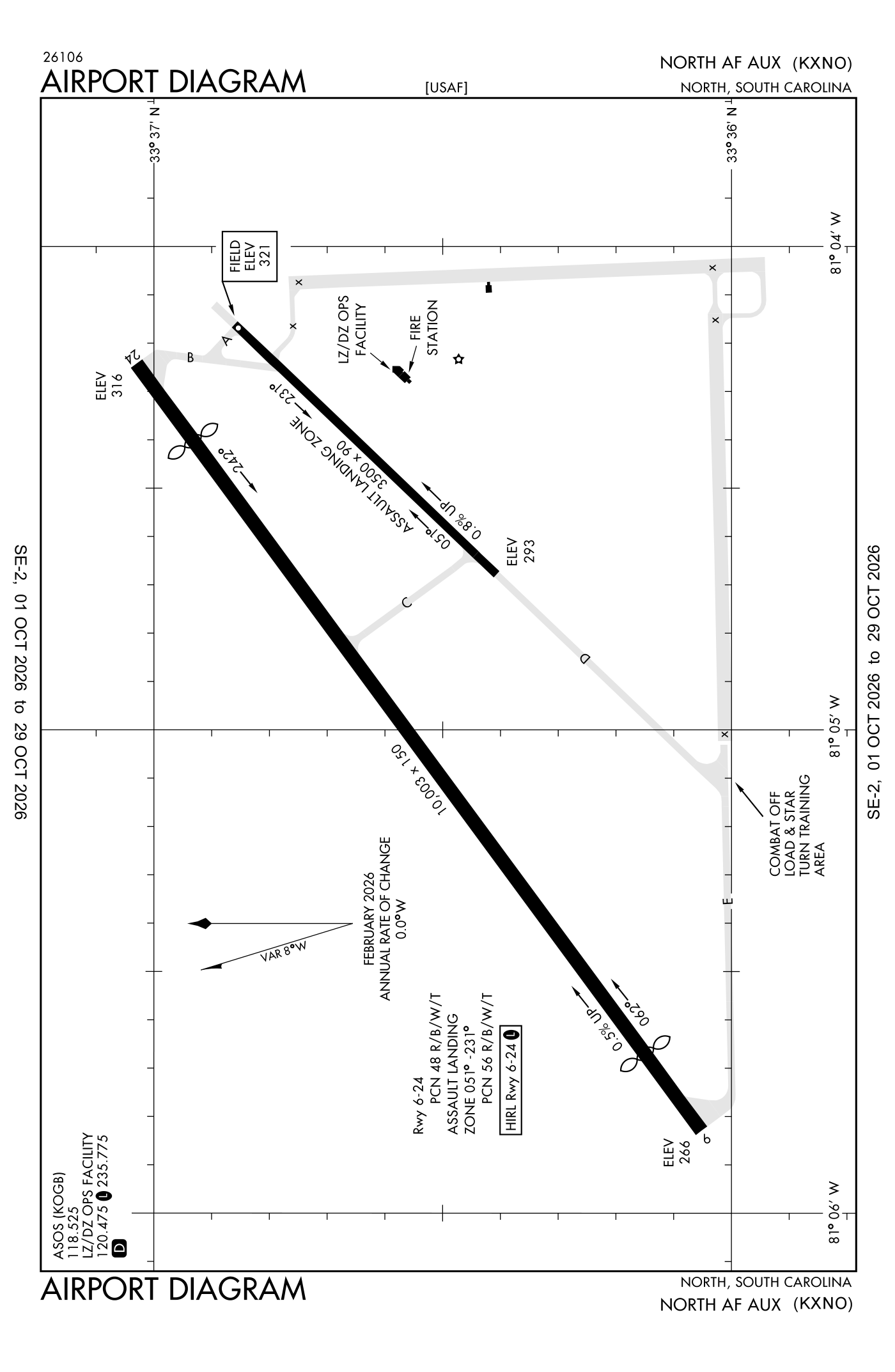
For understanding the field, not for navigation.
| Runway | Length × width | Surface | Lights |
|---|---|---|---|
| 06/24 | 10,003 × 150 ft | Asphalt | High-intensity lights |
| 051/231 | 3,500 × 90 ft | Concrete |
- Runway 06: threshold displaced 1,000 ft, 9,003 ft available for landing
- Runway 24: threshold displaced 1,004 ft, 8,999 ft available for landing
Aircraft registered in North from the FAA register
1 aircraft are registered to owners in North, South Carolina: 1 business jet. Not every one of them is based at this airport; the based-aircraft count above is the FAA's figure for this airport alone.
Individuals are counted, never named. All aircraft registered in South Carolina.
Accidents and incidents at or near this airport NTSB records
No NTSB accident or incident records name this airport.
Nearby within 30 nautical miles
The FAA's remarks as written in the airport file
- Rotating beacon off dur light out training.
- Activate high-intensity runway lights runway 06/24 - 120.475.
- Pattern altitude: rectangular 979 feet above ground level / 1300 feet above sea level, ovhd 1479 feet above ground level / 1800 feet above sea level.
- Z++.
- Z++.
- Closed fed holidays.
- See flip AP/1 supplry airport rmk.
- Caution: ints hvy military jet and misc aircraft exctng nmrs cargo and pers drops, HI-SPEED LO-LEVEL formation flight, and airland operates. Runway 06-24 northwest tree line 750 feet FR runway centerline.
- Caution: runway 06-24 large ditch 350 feet FR runway centerline at midfield on northwest side runway. Ints gnd training on rsvn. Runway 05-23 used as assault landing zone (alz) 3500 feet an X 90 feet.
- Misc: alz runway 05-23 and 06-24 grooved. LZ/DZ operations facility ltd to advsy service only, no air traffic control services provided, aircrews will contact columbia app to required/activate IFR clnc.
- NS abtmt: ovft of North, SC proh.
- Restricted: taxiway delta closed during BOX-IN-ONE operations to alz runway 23.
Facts from the FAA's airport file effective October 1, 2026, written out in plain English; weather from the National Weather Service's aviation weather service; registered aircraft from the FAA register as of October 5, 2026; accidents from the NTSB's public database. Owners are shown only when they are an organisation; no person is named. Check the official sources before a flight: this page is for understanding an airport, not for planning one.