
Tampa International
TPA · KTPA · Tampa, Florida · Hillsborough County · map
Tampa International is a public-use airport owned by Hillsborough CO Avn Authority, 6 miles west of Tampa, Florida, 26 feet above sea level. It has 3 runways; the longest, 01L/19R, is 11,002 feet of concrete. It has a control tower, fuel (100LL avgas, Jet A) and about 76 based aircraft. The FAA counts about 233,167 takeoffs and landings a year. About 11,727,089 passengers boarded flights here in the FAA's fiscal year 2024.
Weather right now KTPA · observed 6:53 pm EDT (22:53 UTC), 38 minutes ago
MVFR flyable but watch the ceiling and visibility
- Wind from the east (100°) at 4 knots
- Visibility 3 miles
- Sky: a few clouds at 800 feet, scattered clouds at 5,500 feet, overcast at 10,000 feet
- Weather: light rain, mist
- Temperature 77°F (25°C), dew point 75°F (24°C)
- Altimeter 29.87 inHg
The forecast issued Tue 5:29 pm EDT (21:29 UTC), good until Wed 8:00 pm EDT (00:00 UTC)
- From Tue 5:00 pm EDT (21:00 UTC): wind from the northeast at 6 knots, visibility 4 miles, rain showers, thunderstorms nearby, a few clouds at 1,500 feet, a broken layer at 3,000 feet (thunderheads) and more above MVFR
- At times between Tue 5:00 pm EDT (21:00 UTC) and 8:00 pm EDT (00:00 UTC): visibility 2 miles, rain showers, a broken layer at 1,500 feet IFR
- From Tue 10:00 pm EDT (02:00 UTC): wind from the east at 5 knots, visibility more than 6 miles, showers nearby, a few clouds at 1,500 feet, scattered clouds at 3,000 feet and more above VFR
- At times between Tue 10:00 pm EDT (02:00 UTC) and 2:00 am EDT (06:00 UTC): visibility 4 miles, rain showers, a broken layer at 1,500 feet MVFR
- From Wed 2:00 am EDT (06:00 UTC): wind light and variable, visibility more than 6 miles, showers nearby, scattered clouds at 700 feet VFR
- At times between Wed 3:00 am EDT (07:00 UTC) and 7:00 am EDT (11:00 UTC): visibility 4 miles, rain showers, a broken layer at 700 feet IFR
- From Wed 7:00 am EDT (11:00 UTC): wind light and variable, visibility more than 6 miles, showers nearby, a broken layer at 700 feet IFR
- From Wed 10:00 am EDT (14:00 UTC): wind from the south at 5 knots, visibility more than 6 miles, showers nearby, scattered clouds at 1,500 feet VFR
- At times between Wed 10:00 am EDT (14:00 UTC) and 2:00 pm EDT (18:00 UTC): visibility 4 miles, rain showers, a broken layer at 700 feet IFR
The codes as issued (METAR and TAF)
METAR KTPA 062253Z 10004KT 3SM -RA BR FEW008 SCT055 OVC100 25/24 A2987 RMK AO2 SLP114 P0018 T02500239
TAF KTPA 062129Z 0621/0724 05006KT 4SM SHRA VCTS FEW015 BKN030CB OVC100 TEMPO 0621/0624 2SM SHRA BKN015 FM070200 10005KT P6SM VCSH FEW015 SCT030 OVC050 TEMPO 0702/0706 4SM SHRA BKN015 FM070600 VRB03KT P6SM VCSH SCT007 TEMPO 0707/0711 4SM SHRA BKN007 FM071100 VRB03KT P6SM VCSH BKN007 FM071400 19005KT P6SM VCSH SCT015 TEMPO 0714/0718 4SM SHRA BKN007
From the National Weather Service's aviation weather service, refreshed every few minutes; times are local to the airport with UTC in brackets. For a flight, get your briefing from Flight Service or an approved provider.
The airport
- Codes
- FAA TPA · ICAO KTPA
- Kind
- Airport · open to the public · publicly owned
- Owner
- Hillsborough CO Avn Authority
- Elevation
- 26 feet above sea level
- Control tower
- A control tower with a TRACON · around the clock
- Attended
- around the clock
- Lights
- runway lights sunset to sunrise; beacon sunset to sunrise
- Fuel
- 100LL avgas, Jet A
- Repairs
- airframe: major repairs; engine: major repairs
- Parking
- hangar, tiedown
- Notes
- customs available · certified for airline service (Part 139)
- On the chart
- Miami sectional
- Magnetic variation
- 5W
- In the FAA's files since
- April 1940
Runways 3
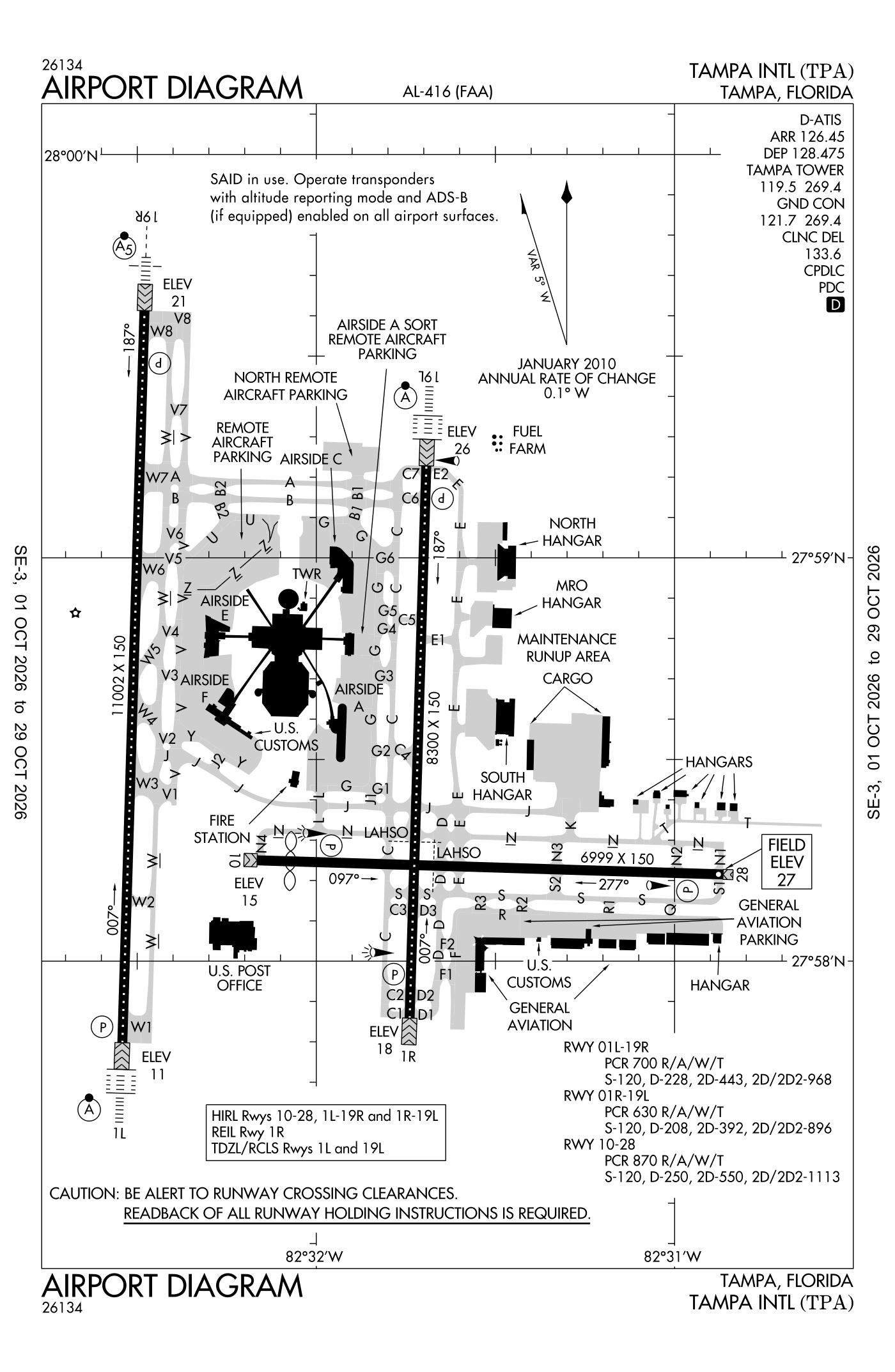
For understanding the field, not for navigation.
| Runway | Length × width | Surface | Lights |
|---|---|---|---|
| 01L/19R | 11,002 × 150 ft | Concrete, good | High-intensity lights |
| 01R/19L | 8,300 × 150 ft | Asphalt and concrete, good | High-intensity lights |
| 10/28 | 6,999 × 150 ft | Asphalt and concrete, fair | High-intensity lights |
- Runway 01L: ILS with DME, PAPI, four lights on the left, approach lights with sequenced flashers (ALSF-2), 10,800 ft available for landing
- Runway 19R: ILS with DME, PAPI, four lights on the left, medium-intensity approach lights with runway alignment lights (MALSR), road 15 ft high 955 ft from the end
- Runway 01R: localizer with DME, PAPI, four lights on the left
- Runway 19L: ILS with DME, PAPI, four lights on the left, approach lights with sequenced flashers (ALSF-2)
- Runway 10: PAPI, four lights on the left, threshold displaced 498 ft, 6,501 ft available for landing, rr 18 ft high 755 ft from the end
- Runway 28: PAPI, four lights on the left, 6,501 ft available for landing, trees 41 ft high 1,660 ft from the end
Radio frequencies
| UNICOM | 122.95 | |
| Digital ATIS · Tpa and automated weather (ASOS) Arrival | 126.45 | Tampa |
| Digital ATIS Departure | 128.475 | Tampa |
| Clearance delivery | 118.075 | |
| Clearance delivery IFR | 119.8 | |
| Clearance delivery | 133.6 | Tampa |
| Ground | 121.7 | Tampa |
| Ground (secondary) | 121.35 | Tampa |
| Tower | 119.5 | Tampa |
| Tower (secondary) | 119.05 | Tampa |
| Approach and departure arriving from headings 001 to 150 | 118.15 | Tampa |
| Approach | 118.5 | Tampa |
| Blfrg and star · Class B airspace · Departure procedure (GANDY) arriving from headings 151 to 219; Runway 23 | 119.65 | Tampa |
| Class B airspace · Approach (secondary) Departure (secondary) · Departure arriving from headings 001 to 150; Runway 05 | 119.9 | Tampa |
| Approach and departure | 120.65 | Bartow |
| Approach · Approach (secondary) Departure (secondary) · Class C (secondary) | 124.95 | Mac Dill |
| Class B airspace · Approach and departure · Departure procedure (BAYPO) arriving from headings 220 to 360; West | 125.3 | Tampa |
| Approach and departure · Departure procedure (TAMPA) arriving from headings 151 to 219 | 134.25 | Tampa |
| Departure procedure (CROWD) · Dades and star · Lubbr and star | 135.5 | Tampa |
| Departure procedure (BAYPO) · Departure · Departure procedure (DORMR) arriving from headings 220 to 360 | 118.8 | Tampa |
| Emergency | 121.5 | Tampa |
Automated weather (ASOS), by phone 813-296-2752.
Based aircraft as counted for the FAA, fiscal year 2024
Takeoffs and landings a year about 233,167, the FAA's fiscal year 2024 (October 2023 to September 2024)
Local flights stay in the traffic pattern or nearby, often practice; travelling flights arrive from or leave for somewhere else. Counts at airports without a tower are the FAA's estimates.
Wind map live wind over the area, from Windy.com
Colours show wind speed, the moving lines its direction; drag the time bar for the coming days. Map and forecast by Windy.com.
Aircraft registered in Tampa from the FAA register
414 aircraft are registered to owners in Tampa, Florida: 246 piston singles, 58 business jets, 37 turboprops, 29 helicopters, 24 piston twins. Not every one of them is based at this airport; the based-aircraft count above is the FAA's figure for this airport alone.
Companies and organisations in town with two or more aircraft:
Individuals are counted, never named. All aircraft registered in Florida.
Accidents and incidents at or near this airport NTSB records · 37 since 1982, 3 fatal
Cases the NTSB recorded with this as the nearest airport, newest first. Each opens the full report in plain English.
Nearby within 30 nautical miles
The FAA's remarks as written in the airport file
- Not nmly available to operations over 75,000 pounds gross weight.
- Runway 10 PAPI unusable 8 degrees left and right of rcl.
- Runway 10 approach surface is 50:1 to marked displaced threshold.
- Runway 10 first 2600 feet concrete; runway 28 first 4400 feet asphalt.
- Runway 19L is noise sensitive to tbjt departures. Runway 01R is noise sensitive to tbjt arrivals. Publd noise abatement procedures in effect.
- Only aircraft with prior pmsn may use terminal apn; all otrs use general aviation apn.
- Bird act on and in the vicinity of airport.
- Txl F and txl R are NON-MOVEMENT areas. Both lctns are unavailable for group IV aircraft with a wingspan gtr than 117 feet WO prior permission required from airport operations. Txl T prior permission required from airport operations required for aircraft with a wingspan gtr than 90 feet.
- Taxilane G west of taxiway B1 closed to wingspan gtr than 118 feet - prior permission required apt operations.
- Rstrs to adg IV or lgr: taxiway E1.
- Txl K1 and txl K2 closed to wingspans gtr than 171 feet, txl K1 and txl K2 closed while wide body txl K1W is in use.
- Taxiway J between taxiway J1 and taxiway J2; taxiway north west of taxiway L; taxiway east north of taxiway J; txl Z 325 feet east of txl V; txl V between taxiway V2 and taxiway V3 are unavailable for group V aircraft with a wingspan gtr than 171 feet WO prior permission required from airport operations.
Facts from the FAA's airport file effective October 1, 2026, written out in plain English; weather from the National Weather Service's aviation weather service; registered aircraft from the FAA register as of October 5, 2026; accidents from the NTSB's public database. Owners are shown only when they are an organisation; no person is named. Check the official sources before a flight: this page is for understanding an airport, not for planning one.