
Patrick Space Force Base
COF · KCOF · Cocoa Beach, Florida · Brevard County · map
Patrick Space Force Base is a private airport owned by Usaf, 3 miles south of Cocoa Beach, Florida, 8 feet above sea level. It has 2 runways; the longest, 03/21, is 9,008 feet of asphalt and concrete. It has a control tower and fuel (Jet A with additives).
Private use: permission from the owner is required before landing here.
Weather right now KCOF · observed 6:10 pm EDT (22:10 UTC), 44 minutes ago
VFR good flying weather
- Wind from the north-northeast (020°) at 8 knots
- Visibility 10 miles or more
- Sky: a few clouds at 1,800 feet, scattered clouds at 2,500 feet, scattered clouds at 3,300 feet
- Weather: light rain
- Temperature 81°F (27°C), dew point 75°F (24°C)
- Altimeter 29.82 inHg
The forecast issued Tue 2:00 pm EDT (18:00 UTC), good until Wed 8:00 pm EDT (00:00 UTC)
- From Tue 2:00 pm EDT (18:00 UTC): wind from the northeast at 9 knots, showers nearby, a few clouds at 1,500 feet, scattered clouds at 2,500 feet and more above VFR
- Changing between Tue 3:00 pm EDT (19:00 UTC) and 4:00 pm EDT (20:00 UTC) to: wind from the northeast at 9 knots, light rain, thunderstorms nearby, a broken layer at 1,800 feet (thunderheads), overcast at 11,000 feet MVFR
- At times between Tue 4:00 pm EDT (20:00 UTC) and 8:00 pm EDT (00:00 UTC): wind from the northeast at 10 knots, gusting to 15, light thunderstorms with rain, overcast at 1,800 feet (thunderheads) MVFR
- Changing between Tue 8:00 pm EDT (00:00 UTC) and 9:00 pm EDT (01:00 UTC) to: wind light and variable, light rain, a broken layer at 1,000 feet, overcast at 9,000 feet MVFR
- Changing between Wed 3:00 am EDT (07:00 UTC) and 4:00 am EDT (08:00 UTC) to: wind from the north-northwest at 9 knots, showers nearby, scattered clouds at 500 feet, a broken layer at 10,000 feet and more above VFR
- At times between Wed 4:00 am EDT (08:00 UTC) and 10:00 am EDT (14:00 UTC): a broken layer at 500 feet IFR
- Changing between Wed 12:00 pm EDT (16:00 UTC) and 1:00 pm EDT (17:00 UTC) to: wind from the north at 10 knots, gusting to 15, light rain, overcast at 2,500 feet MVFR
- At times between Wed 1:00 pm EDT (17:00 UTC) and 5:00 pm EDT (21:00 UTC): wind from the north at 12 knots, gusting to 18, light thunderstorms with rain, overcast at 2,000 feet (thunderheads) MVFR
The codes as issued (METAR and TAF)
SPECI KCOF 062210Z AUTO 02008KT 10SM -RA FEW018 SCT025 SCT033 27/24 A2982 RMK AO2 DZB2159E01RAB01 SLP102
TAF KCOF 061800Z 0618/0724 04009KT 9999 VCSH FEW015 SCT025 BKN190 QNH2983INS BECMG 0619/0620 04009KT 8000 -RA VCTS BKN018CB OVC110 QNH2981INS TEMPO 0620/0624 04010G15KT -TSRA OVC018CB BECMG 0700/0701 VRB06KT 8000 -RA BKN010 OVC090 QNH2980INS BECMG 0707/0708 34009KT 9999 VCSH SCT005 BKN100 OVC140 QNH2977INS TEMPO 0708/0714 BKN005 BECMG 0716/0717 01010G15KT 8000 -RA OVC025 QNH2977INS TEMPO 0717/0721 01012G18KT -TSRA OVC020CB TX29/0618Z TN24/0707Z
From the National Weather Service's aviation weather service, refreshed every few minutes; times are local to the airport with UTC in brackets. For a flight, get your briefing from Flight Service or an approved provider.
The airport
- Codes
- FAA COF · ICAO KCOF
- Kind
- Airport · private use, permission required · owned by the Air Force
- Owner
- Usaf
- Elevation
- 8 feet above sea level
- Control tower
- A control tower · 1300-0500z++ mon-fri; sat-sun closed; holidays closed. air field closed third friday of month.
- Attended
- M to F, 1:00 pm to 0500z+; weekends, closed; holidays, closed
- Lights
- beacon sunset to sunrise
- Fuel
- Jet A with additives
- Repairs
- airframe: none; engine: none
- On the chart
- Jacksonville sectional
- Magnetic variation
- 7W
- In the FAA's files since
- February 1944
Runways 2
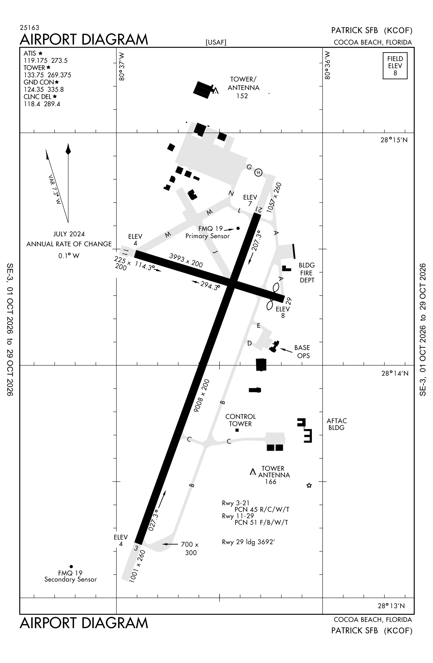
For understanding the field, not for navigation.
| Runway | Length × width | Surface | Lights |
|---|---|---|---|
| 03/21 | 9,008 × 200 ft | Asphalt and concrete | High-intensity lights |
| 11/29 | 3,993 × 200 ft | Asphalt | Medium-intensity lights |
- Runway 03: localizer and glideslope, PAPI, four lights on the left, approach lights with sequenced flashers (ALSF-1)
- Runway 21: localizer and glideslope, PAPI, four lights on the left
- Runway 11: PAPI, four lights on the left
- Runway 29: PAPI, four lights on the left, threshold displaced 301 ft
Radio frequencies
| ATIS (recorded airport information) | 119.175 | Patrick |
| Clearance delivery | 118.4 | Patrick |
| Ground | 124.35 | Patrick |
| Tower | 133.75 | Patrick |
| Approach and departure · Departure procedure (OCEAN) · Departure procedure (RIVER) | 126.025 | Patrick |
| Emergency | 121.5 | Patrick |
| Pilot-to-weather (military) and metro | 123.25 | Patrick |
| Bitho and star | 128.375 | Patrick |
| Operations Rescue operations | 138.475 | Patrick |
| Comd and post · Pre-taxi clearance Patrick | 139.3 | Patrick |
| Operations King operations | 150.35 | Patrick |
Aircraft registered in Cocoa Beach from the FAA register
28 aircraft are registered to owners in Cocoa Beach, Florida: 22 piston singles, 3 piston twins, 2 business jets, 1 balloon. Not every one of them is based at this airport; the based-aircraft count above is the FAA's figure for this airport alone.
Individuals are counted, never named. All aircraft registered in Florida.
Accidents and incidents at or near this airport NTSB records
No NTSB accident or incident records name this airport.
Nearby within 30 nautical miles
The FAA's remarks as written in the airport file
- Traffic pattern: 1500 feet above sea level rectangular, 2000 feet above sea level ovhd.
- Closed every third Friday of the month.
- DSN-854-2222
- Caution: NON-STD threshold light.
- Both standard and assault landing zone markings.
- Both standard and assault landing zone markings.
- PAPI unusable beyond 7 degrees left and 9 degrees right of centerline.
- First 1000 feet grooved concrete; mid 7000 feet asphalt.
- Noise abatement information - airfield operations dsn 854-2222/C321-494-2222.
- Jasu; 3(MA-1A); 5(MD-3B).
- Caution: first 240 feet of runway 29 not visibility from tower. Dur VFR weather condition exer caution due to extv local gen avn aircraft ovr melbourne international 7 NM south.
- Fluid: SP presair lhox lox
Facts from the FAA's airport file effective October 1, 2026, written out in plain English; weather from the National Weather Service's aviation weather service; registered aircraft from the FAA register as of October 5, 2026; accidents from the NTSB's public database. Owners are shown only when they are an organisation; no person is named. Check the official sources before a flight: this page is for understanding an airport, not for planning one.