
City Of Colorado Springs Municipal
COS · KCOS · Colorado Springs, Colorado · El Paso County · map
City Of Colorado Springs Municipal is a public-use airport owned by the City of Colorado Springs, 6 miles southeast of Colorado Springs, Colorado, 6,187 feet above sea level. It has 3 runways; the longest, 17L/35R, is 13,500 feet of concrete. It has a control tower, fuel (100LL avgas, Jet A) and about 227 based aircraft. The FAA counts about 178,342 takeoffs and landings a year. About 1,263,211 passengers boarded flights here in the FAA's fiscal year 2024.
Weather and planning now, the forecast, warnings, pilot reports, winds aloft, restrictions
Weather right now KCOS · observed 4:54 am MDT (10:54 UTC), 55 minutes ago
LIFR very low ceiling or visibility
- Wind from the east (090°) at 9 knots
- Visibility 2 miles
- Sky: overcast at 300 feet
- Weather: light rain, mist
- Temperature 44°F (7°C), dew point 43°F (6°C)
- Altimeter 30.14 inHg
The forecast issued Wed 5:21 am MDT (11:21 UTC), good until Thu 6:00 am MDT (12:00 UTC)
- From Wed 6:00 am MDT (12:00 UTC): wind from the southeast at 9 knots, visibility 3 miles, mist, showers nearby, scattered clouds at 400 feet, overcast at 1,400 feet MVFR
- At times between Wed 6:00 am MDT (12:00 UTC) and 9:00 am MDT (15:00 UTC): visibility 1 mile, rain showers, mist, overcast at 400 feet LIFR
- From Wed 9:00 am MDT (15:00 UTC): wind from the southeast at 9 knots, visibility more than 6 miles, scattered clouds at 400 feet, overcast at 1,400 feet MVFR
- 30% chance between Wed 9:00 am MDT (15:00 UTC) and 1:00 pm MDT (19:00 UTC): visibility 3 miles, light rain showers, mist, overcast at 500 feet IFR
- From Wed 1:00 pm MDT (19:00 UTC): wind from the southeast at 12 knots, visibility 2 miles, light rain showers, mist, overcast at 800 feet IFR
- From Wed 4:00 pm MDT (22:00 UTC): wind from the south at 7 knots, visibility 2 miles, light rain showers, mist, overcast at 800 feet IFR
- From Wed 8:00 pm MDT (02:00 UTC): wind from the south-southeast at 6 knots, visibility more than 6 miles, a broken layer at 900 feet IFR
- From Thu 12:00 am MDT (06:00 UTC): wind from the north at 7 knots, visibility more than 6 miles, overcast at 700 feet IFR
The codes as issued, and in English (METAR and TAF)
METAR KCOS 141054Z 09009KT 2SM -RA BR OVC003 07/06 A3014 RMK AO2 RAB20 CIG 002V005 SLP164 P0001 T00670061 $
- METAR
- a routine hourly observation
- KCOS
- the station, KCOS
- 141054Z
- observed 4:54 am MDT (10:54 UTC)
- 09009KT
- wind from the east at 9 knots
- 2SM
- visibility 2 miles
- -RA
- light rain
- BR
- mist
- OVC003
- overcast at 300 feet
- 07/06
- temperature 7 °C (45 °F), dew point 6 °C (43 °F)
- A3014
- altimeter setting 30.14 inches of mercury
- RMK
- remarks follow
- AO2
- automated station with a precipitation sensor
- RAB20
- rain began 20 minutes past the hour
- CIG 002V005
- ceiling varying between 200 and 500 feet
- SLP164
- sea-level pressure 1016.4 hPa
- P0001
- 0.01 inches of precipitation in the last hour
- T00670061
- temperature 6.7 °C (44 °F), dew point 6.1 °C (43 °F)
- $
- the station needs maintenance
TAF KCOS 141121Z 1412/1512 14009KT 3SM BR VCSH SCT004 OVC014 TEMPO 1412/1415 1SM SHRA BR OVC004 FM141500 14009KT P6SM SCT004 OVC014 PROB30 1415/1419 3SM -SHRA BR OVC005 FM141900 13012KT 2SM -SHRA BR OVC008 FM142200 18007KT 2SM -SHRA BR OVC008 FM150200 15006KT P6SM BKN009 FM150600 01007KT P6SM OVC007
- TAF
- a terminal aerodrome forecast: the weather expected at the airport, usually for the next 24 or 30 hours
- KCOS
- the station, KCOS
- 141121Z
- issued 5:21 am MDT (11:21 UTC)
- 1412/1512 14009KT 3SM BR VCSH SCT004 OVC014
- valid from Wed 6:00 am MDT (12:00 UTC) to Thu 6:00 am MDT (12:00 UTC): wind from the southeast at 9 knots, visibility 3 miles, mist, vcsh, scattered clouds at 400 feet, overcast at 1,400 feet
- TEMPO 1412/1415 1SM SHRA BR OVC004
- at times from Wed 6:00 am MDT (12:00 UTC) to Wed 9:00 am MDT (15:00 UTC): visibility 1 mile, rain showers, mist, overcast at 400 feet
- FM141500 14009KT P6SM SCT004 OVC014
- from Wed 9:00 am MDT (15:00 UTC): wind from the southeast at 9 knots, visibility more than 6 miles, scattered clouds at 400 feet, overcast at 1,400 feet
- PROB30 1415/1419 3SM -SHRA BR OVC005
- a 30% chance from Wed 9:00 am MDT (15:00 UTC) to Wed 1:00 pm MDT (19:00 UTC): visibility 3 miles, light rain showers, mist, overcast at 500 feet
- FM141900 13012KT 2SM -SHRA BR OVC008
- from Wed 1:00 pm MDT (19:00 UTC): wind from the southeast at 12 knots, visibility 2 miles, light rain showers, mist, overcast at 800 feet
- FM142200 18007KT 2SM -SHRA BR OVC008
- from Wed 4:00 pm MDT (22:00 UTC): wind from the south at 7 knots, visibility 2 miles, light rain showers, mist, overcast at 800 feet
- FM150200 15006KT P6SM BKN009
- from Wed 8:00 pm MDT (02:00 UTC): wind from the south-southeast at 6 knots, visibility more than 6 miles, a broken layer at 900 feet
- FM150600 01007KT P6SM OVC007
- from Thu 12:00 am MDT (06:00 UTC): wind from the north at 7 knots, visibility more than 6 miles, overcast at 700 feet
From the National Weather Service's aviation weather service, refreshed every few minutes; times are local to the airport with UTC in brackets. For a flight, get your briefing from Flight Service or an approved provider.
Flight planning warnings, pilot reports, winds aloft, restrictions · for planning, not a briefing
2 warnings in force over this field:
- AIRMET SIERRA 9E: low cloud or poor visibility (IFR conditions) (due to ceilings below 1,000 ft, visibility below 3 miles, precipitation, mist).
- AIRMET SIERRA 1E: mountains obscured by cloud (due to mountains obscured by clouds, precipitation, mist).
Turbulence No turbulence warning in force over this field. 1 pilot report of turbulence within 100 nautical miles in the last three hours: moderate turbulence, at 23,000 ft, 72 nm northwest, 5:23 am MDT (11:23 UTC). The government's turbulence forecast map ↗
Icing No icing warning in force over this field. A pilot reported no icing, at 10,000 ft, 64 nm north, 5:41 am MDT (11:41 UTC). The freezing level is about 13,000 ft (from the winds-aloft temperatures), so icing is possible in cloud above that. The government's icing forecast map ↗
6 pilot reports within 100 nautical miles in the last three hours, the nearest three:
- B763 at 23,500 ft, 48 nm west, 4:59 am MDT (10:59 UTC): no turbulence, remarks: during the descent ZDVWC-26.
as filed, and in English
DEN UA /OV DEN217069/TM 1059/FL235/TP B763/TB NEG/RM DURD. ZDVWC-26
- Report
- a routine report filed through DEN
- Where
- 69 nm southwest (217°) of DEN
- Time
- 10:59 UTC
- Height
- at 23,500 ft
- Aircraft
- B763
- Turbulence
- none
- Remarks
- during the descent ZDVWC-26
- B39M at 5,700 ft, 60 nm north, 5:06 am MDT (11:06 UTC): a routine report with nothing remarked on.
as filed, and in English
DEN UA /OV RY34R/TM 1106/FL057/TP B39M/SK BASES 057
- Report
- a routine report filed through DEN
- Where
- runway 34R
- Time
- 11:06 UTC
- Height
- at 5,700 ft
- Aircraft
- B39M
- Sky
- bases 5,700 ft
- A306 at 7,000 ft, 60 nm north, 4:10 am MDT (10:10 UTC): a routine report with nothing remarked on.
as filed, and in English
DEN UA /OV RY35L/TM 1010/FL070/TP A306/SK TOPS 120 BASES 004
- Report
- a routine report filed through DEN
- Where
- runway 35L
- Time
- 10:10 UTC
- Height
- at 7,000 ft
- Aircraft
- A306
- Sky
- tops 12,000 ft bases 400 ft
Winds aloft at the nearest forecast point (PUB, 32 nm south), for use 08:00–15:00 UTC: 9,000 ft: 180° at 11 kt, 7 °C; 12,000 ft: 190° at 21 kt, 2 °C; 18,000 ft: 220° at 45 kt, -11 °C.
No temporary flight restriction within 50 nautical miles.
26 notices to air missions in force at this field.
- closed Apron east Terminal APN northeast 100 ft closed until Fri 23 Oct, 3:00 pm MDT (21:00 UTC) · COS 10/015
as issued
!COS 10/015 COS APRON EAST TERMINAL APN NE 100FT CLSD 2610051412-2610232100
From the government's aviation weather service and the FAA's restriction list, refreshed every few minutes. This is for planning; the legal briefing comes from Flight Service or the FAA's own tools. The notices come from the FAA's notice service, the site's copy refreshed every few minutes (last checked 2 minutes ago). The FAA has so far issued eFlight its test feed, which misses some notices; the request for the full feed is with the FAA.
Wind map live wind over the area, from Windy.com
Colours show wind speed, the moving lines its direction; drag the time bar for the coming days. Map and forecast by Windy.com.
The airport facts, runways, radio, fuel and services, the FAA's remarks
The airport
- Codes
- FAA COS · ICAO KCOS
- Kind
- Airport · open to the public · publicly owned
- Owner
- City of Colorado Springs
- Elevation
- 6,187 feet above sea level
- Control tower
- A control tower with a TRACON · around the clock
- Attended
- around the clock
- Lights
- runway lights see the remarks below; beacon sunset to sunrise
- Fuel and services
- 100LL avgas, Jet A; the services card below
- Notes
- landing fee · certified for airline service (Part 139)
- On the chart
- Denver sectional
- Magnetic variation
- 8E
- In the FAA's files since
- April 1940
Runways 3
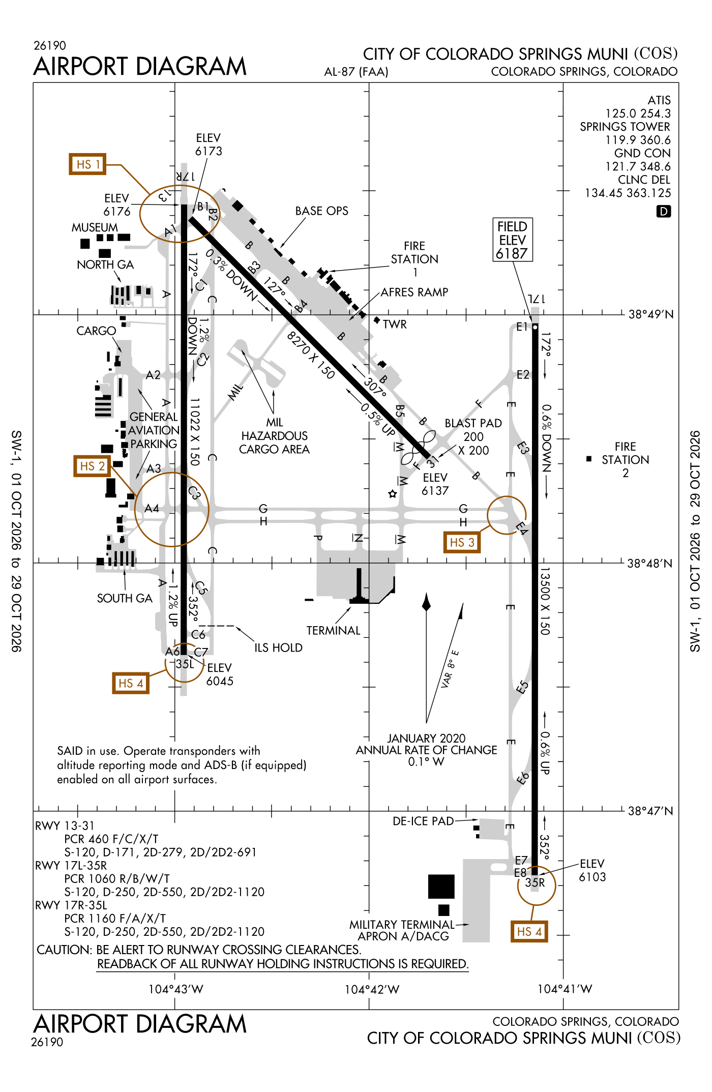
For understanding the field, not for navigation.
| Runway | Length × width | Surface | Lights |
|---|---|---|---|
| 17L/35R | 13,500 × 150 ft | Concrete, good | High-intensity lights |
| 17R/35L | 11,022 × 150 ft | Asphalt, good | High-intensity lights |
| 13/31 | 8,270 × 150 ft | Asphalt, good | Medium-intensity lights |
- Runway 17L: ILS with DME, PAPI, four lights on the left, medium-intensity approach lights with runway alignment lights (MALSR)
- Runway 35R: ILS with DME, PAPI, four lights on the right
- Runway 17R: PAPI, four lights on the left
- Runway 35L: ILS, PAPI, four lights on the left, medium-intensity approach lights with runway alignment lights (MALSR)
- Runway 13: PAPI, four lights on the right
- Runway 31: PAPI, four lights on the left, threshold displaced 356 ft, 7,914 ft available for landing, hill 10 ft high 400 ft from the end
Radio frequencies
| UNICOM | 122.95 | |
| ATIS (recorded airport information) · Cos and automated weather (ASOS) | 125.0 | Springs |
| Clearance delivery | 134.45 | Springs |
| Ground | 121.7 | Springs |
| Tower | 119.9 | Springs |
| Tower (secondary) | 133.15 | Springs |
| Approach · Class C airspace · Departure | 124.0 | Springs |
| Approach (secondary) | 120.6 | Springs |
| Emergency | 121.5 | Springs |
| Cos and vot | 110.4 | |
| Pre-taxi clearance | 122.85 | Springs |
Automated weather (ASOS), by phone 719-694-7502.
Fuel and services as reported to the FAA
- Fuel
- 100LL avgas, Jet A
- Repairs
- airframe and engine: major repairs
- Parking
- hangars, tie-downs
- Oxygen
- bulk oxygen (high-pressure)
- Also here
- air freight, air ambulance, avionics, cargo handling, charter flights, flight instruction, aircraft rental, aircraft sales, aerial surveying
- Notes
- landing fee charged
Other fields with jet fuel nearby: Fremont County (30 nm southwest), Pueblo Memorial (32 nm south), Centennial Airport (46 nm north).
The FAA's file records what is sold and done at the field, as the airport manager reports it, not who sells it or the price; fuel sellers (FBOs) are not named in any public file. Airports selling jet fuel in Colorado · avgas.
The FAA's remarks as written in the airport file, spelled out
- Turbo jet training flights prohibited 11:00 pm to 6:00 am.
- B52 operations prohibited.
- Lighted wdi approach runway 17L/35R, 17R/35L and 13/31.
- Jasu: 2(AM32A-95) 2MA32A-60A 2(MA32-86A) 1(sgnc) 2(B809D-GENERATORS).
- Oil: O-133-148-156(military).
- Portions of taxiways a, B, east, F, G, and M are blocked from view from the tower by obstructions. Portions of taxiway C and runway 17R/35L are blocked from view from the tower when the infield military operating surface is occupied by a C17 or C5.
- Waterfowl and migratory bird activity on and in the vicinity of airport.
- A/dacg ramp light 140 feet above ground level.
- Be alert; intensive usaf student training in the vicinity of Colorado Springs and pueblo Colorado.
- Ctn: aircraft with wingspan greater than 117 feet; when taxi on centerline A2, A3, A4, use oversteer in turns due to insufficient corner fillets in pavement.
- FUEL-A++(military)
- When crossing runway 17R/35L from A1 to B1 or B1 to A1, be aware you will not see A1 or B1 depending on direction crossing until you crest runway 17R/35L. when crossing from A1 to B1 travel northeast and from B1 to A1 travel southwest.
Flights and activity in the air now, the airlines, based aircraft, takeoffs and landings
Activity now checking the volunteer receiver network…
Within ten miles
- Looking…
Arrivals and departures, last hour
- Looking…
From the volunteer receiver network, a few minutes behind at most; aircraft whose owners asked the FAA not to be displayed are left out; no person is named. Open the live map here.
Scheduled and charter flights from here the DOT's airline reports · August 2025 to July 2026
Airlines reported 14,609 departures from COS in those twelve months, carrying 1,229,128 passengers in 1,597,102 seats (77% filled), to 116 destinations (4 abroad) on 31 airlines.
All 116 destinations, the airlines and the aircraft, month by month
From the Bureau of Transportation Statistics' T-100 table: every segment an airline reported flying, three months in arrears. Private, business and training flights are not in it; the live picture is in the activity card.
Based aircraft as counted for the FAA, fiscal year 2024
Based aircraft, as a table
| aircraft | |
|---|---|
| single-engine | 154 |
| multi-engine | 35 |
| jets | 22 |
| helicopters | 2 |
| other | 14 |
Takeoffs and landings a year about 178,342, the FAA's fiscal year 2024 (October 2023 to September 2024)
Takeoffs and landings, as a table
| a year | |
|---|---|
| airline | 23,204 |
| air taxi and commuter | 18,138 |
| general aviation, travelling | 48,093 |
| general aviation, local | 66,522 |
| military | 22,385 |
Local flights stay in the traffic pattern or nearby, often practice; travelling flights arrive from or leave for somewhere else. Counts at airports without a tower are the FAA's estimates. How this compares nationally: Airports by the numbers.
Who flies and works here aircraft registered in town, the companies, the examiners nearby
Aircraft registered in Colorado Springs from the FAA register
555 aircraft are registered to owners in Colorado Springs, Colorado: 382 piston singles, 56 balloons, 37 piston twins, 29 turboprops, 15 business jets. Not every one of them is based at this airport; the based-aircraft count above is the FAA's figure for this airport alone.
Companies and organisations in town with two or more aircraft:
Individuals are counted, not named (the site's policy at this time). All aircraft registered in Colorado.
Who works here from the FAA's certificate lists and the register
Fuel and service companies in Colorado Springs, by their names on the register (a start, not a directory):
- Cessna 23117 Aviation Services LLC
- Cirrus Aviation Services LLC Cirrus Aviation Services is a private aviation management and charter company operating since 2009.
- Fly-By Aviation Services LLC
- N2724H Aviation Services LLC
- N909Db Aviation Services LLC
- Piper 4795Y Aviation Services LLC
Flight schools, flying clubs and college flight programmes in Colorado Springs, by their names on the register:
- Pikes Peak Flyers LLP 6 aircraft Pikes Peak Flyers is a privately owned aircraft sales and services facility located at Colorado Springs Airport.
- Arapahoe Flight Club LLC 5 aircraft Arapahoe Flight Club is a Part 141 certified flight school in Colorado Springs offering fixed-wing and helicopter pilot training, discovery flights, and aircraft rental.
- Good Guys Flying Club LLC 2 aircraft
- Colorado High Flyers LLC 1 aircraft
- Falcon Flight Academy LLC 1 aircraft Falcon AeroLab is a STEM and aerospace education programme for middle and high school students, founded in 2017 and headquartered in Colorado.
- Frontier Adventure Flyers LLC 1 aircraft
Charter operators and airlines based in Colorado Springs:
- Rampart Aviation, LLC 15 aircraft on the certificate Rampart Aviation is a veteran-owned FAA Part 135 on-demand air carrier and FAA Part 145 repair station based in Colorado Springs, Colorado.
- SkyRoads Aviation 1 aircraft on the certificate Skyroads Aviation is an on-demand charter operator based in Colorado Springs, Colorado.
Repair stations in Colorado Springs:
- C7 Aerowerks, LLC
- Colorado Airworks LLC Colorado Airworks LLC is a FAA-certified repair station specializing in hot air balloon maintenance, annual inspections, and parts sourcing for all major balloon manufacturers.
- D & J Aviation INC
- Fourth Front Aviation Colorado INC Fourth Front Aviation is a veteran-owned aircraft maintenance shop operating at Santa Monica Airport (KSMO) and Colorado Springs Airport (KCOS).
- M e K LTD
- Trine Aerospace, LLC
- Westpac Propeller Services INC
Companies in the same town as this airport; not every one of them works from this field. All operators · all repair stations · all flight schools · all FBOs.
Examiners and inspectors nearby designated by the FAA · within 50 nautical miles
5 pilot examiners (the FAA's designated pilot examiners, who give the practical tests for pilot certificates) are based within 50 nautical miles: 5 for private pilot, 5 for commercial and instrument, 2 for airline transport pilot, 5 for flight instructor; 5 for airplanes, 5 for multi-engine airplanes. Also nearby: 1 sport aviation examiner, 16 aviation medical examiners, 2 mechanic examiners, 1 airworthiness representative (maintenance), 2 airworthiness representatives (manufacturing), 17 engineering representatives, 5 aircraft dispatcher examiners, 1 training center evaluator, 1 aircrew program designee, 1 administrative pilot examiner.
- Christina Genova private pilot, commercial and instrument, flight instructor, instructor renewals, military competency, ground instructor, foreign pilot certificates; airplanes, multi-engine airplanes · Pueblo, CO (32 nm) · (719) 240-1942 · kansasdpe@gmail.com
- Adam Christopher Adrian private pilot, commercial and instrument, flight instructor, instrument instructor, instructor renewals, ground instructor; airplanes, multi-engine airplanes · Centennial, CO (47 nm) · (509) 771-0726 · acadrianmail@yahoo.com
- Gregory Richard Newman private pilot, commercial and instrument, flight instructor, instructor renewals, military competency, ground instructor, foreign pilot certificates; airplanes, multi-engine airplanes · ASPEN FLYING CLUB · Englewood, CO (47 nm) · (480) 544-3421 · grnewman@mac.com
- Nelson Jacob Wolfmeier private pilot, commercial and instrument, airline transport pilot, flight instructor, instructor renewals, military competency, ground instructor, foreign pilot certificates; airplanes, multi-engine airplanes · Aspen Flying Club · Centennial, CO (47 nm) · (303) 736-9554 · jwolfmeier@yahoo.com
- craig thighe private pilot, commercial and instrument, airline transport pilot, flight instructor, instrument instructor, instructor renewals, military competency, ground instructor; airplanes, multi-engine airplanes · Four19 Aviation, LLC · Englewood, CO (47 nm) · (720) 238-7950 · cthighe@gmail.com
All 52 nearby, by kind, with contact details
What each kind does
- DPE: Designated Pilot Examiner: gives the practical tests (checkrides) for pilot certificates and ratings.
- SAE: Sport Aviation Examiner: gives the tests for sport pilot certificates and light-sport aircraft.
- AME: Aviation Medical Examiner: a doctor who issues the medical certificates pilots must hold.
- DME: Designated Mechanic Examiner: tests candidates for the mechanic certificate (airframe and powerplant).
- DAR-T: Designated Airworthiness Representative, maintenance: issues airworthiness certificates and approvals for aircraft in service.
- DAR-F: Designated Airworthiness Representative, manufacturing: issues airworthiness certificates for newly built aircraft and parts.
- DER-T: Designated Engineering Representative: approves engineering data for repairs and alterations on the FAA's behalf.
- DADE: Designated Aircraft Dispatcher Examiner: tests candidates for the dispatcher certificate.
- TCE: Training Center Evaluator: gives tests at a simulator training center.
- APD: Aircrew Program Designee: an airline's own check pilot who gives the FAA's tests to the airline's pilots.
- Admin-PE: Administrative Pilot Examiner: handles certificate paperwork rather than flight tests.
Designees are listed with the name and contact details the FAA publishes for them on its designee locator (read October 10, 2026): the FAA lists them so that pilots, mechanics and companies can find them. Private individuals are not named, the site's policy at this time. A designee who would rather not appear here can ask us through the contact address on the About page. Each designee is placed at the main public airport of the town the FAA lists (or the nearest one to its zip code), so "nearby" means the town, not an exact address. All examiners by state.
Safety record the NTSB's cases at or near this airport
Accidents and incidents at or near this airport NTSB records · 60 since 1982, 5 fatal
Cases the NTSB recorded with this as the nearest airport, newest first. Each opens the full report in plain English. The country as a whole: Where accidents happen.
Nearby within 30 nautical miles
Connections how this airport links to the rest of the register
- Aircraft registered in Colorado Springs 555 aircraft · 382 piston singles, 56 balloons, 37 piston twins
- Tactical Integrated Training Solutions LLC 16 aircraft in town
- Greatest Generation Naval Museum 12 aircraft in town
- Sanborn Map Company INC 10 aircraft in town
- Sanborn Map CO INC 7 aircraft in town
- Cessna 23117 Aviation Services LLC 1 aircraft · FBO or fuel seller
- Cirrus Aviation Services LLC 1 aircraft · FBO or fuel seller
- Fly-By Aviation Services LLC 1 aircraft · FBO or fuel seller
- Rampart Aviation, LLC 15 aircraft on the certificate · charter operator
- SkyRoads Aviation 1 aircraft on the certificate · charter operator
- Pikes Peak Flyers LLP 6 aircraft · flight school
- Arapahoe Flight Club LLC 5 aircraft · flying club
- Good Guys Flying Club LLC 2 aircraft · flying club
- C7 Aerowerks, LLC · repair station
- Colorado Airworks LLC · repair station
- D & J Aviation INC · repair station
- Fourth Front Aviation Colorado INC · repair station
- Denver International (DEN) 5,351 flights in twelve months · SkyWest Airlines Inc., Southwest Airlines Co.
- Dallas-Fort Worth International (DFW) 1,897 flights in twelve months · American Airlines Inc., SkyWest Airlines Inc.
- Phoenix Sky Harbor International (PHX) 1,009 flights in twelve months · Southwest Airlines Co., SkyWest Airlines Inc.
- Chicago O'Hare International (ORD) 992 flights in twelve months · SkyWest Airlines Inc., United Air Lines Inc.
- Harry Reid International (LAS) 862 flights in twelve months · Southwest Airlines Co., Sun Country Airlines d/b/a MN Airlines
- Dallas Love Field (DAL) 790 flights in twelve months · Southwest Airlines Co.
- Salt Lake City International (SLC) 731 flights in twelve months · SkyWest Airlines Inc., Delta Air Lines Inc.
- George Bush Intcntl/Houston (IAH) 726 flights in twelve months · Mesa Airlines Inc., SkyWest Airlines Inc.
- NTSB accidents and incidents at or near this airport 60 since 1982 · 5 fatal
- Accidents and incidents in Colorado 2,857 since 1982 · 381 in the last ten years
- Nearby landing places within 30 nautical miles 8 airports, heliports and seaplane bases
- Public-use airports in Colorado 76 landing places
- Colorado 7,453 aircraft registered
The whole map of how records connect · these connections as data: /graph/airport/COS.json.
Facts from the FAA's airport file effective October 1, 2026, written out in plain English; weather from the National Weather Service's aviation weather service; registered aircraft from the FAA register as of October 13, 2026; accidents from the NTSB's public database. Owners are shown only when they are an organisation; no person is named. Check the official sources before a flight: this page is for understanding an airport, not for planning one.