
MC Connell Air Force Base
IAB · KIAB · Wichita, Kansas · Sedgwick County · map
MC Connell Air Force Base is a private airport owned by Usaf, 4 miles south of Wichita, Kansas, 1,372 feet above sea level. It has 2 runways; the longest, 01R/19L, is 12,007 feet of asphalt. It has a control tower.
Private use: permission from the owner is required before landing here.
Weather right now KIAB · observed 9:55 pm CDT (02:55 UTC), 14 minutes ago
VFR good flying weather
- Wind from the south-southwest (200°) at 5 knots
- Visibility 10 miles or more
- Temperature 72°F (22°C), dew point 58°F (15°C)
- Altimeter 30.01 inHg
The forecast issued Thu 9:00 pm CDT (02:00 UTC), good until Sat 3:00 am CDT (08:00 UTC)
- From Thu 9:00 pm CDT (02:00 UTC): wind from the south-southwest at 6 knots, clear skies
- Changing between Fri 9:00 am CDT (14:00 UTC) and 10:00 am CDT (15:00 UTC) to: wind from the south-southwest at 10 knots, gusting to 18, clear skies
- Changing between Fri 6:00 pm CDT (23:00 UTC) and 7:00 pm CDT (00:00 UTC) to: wind from the south at 6 knots, clear skies
The codes as issued (METAR and TAF)
METAR KIAB 090255Z AUTO 20005KT 10SM CLR 22/15 A3001 RMK AO2 SLP154 T02200146 52010
TAF KIAB 090200Z 0902/1008 20006KT 9999 SKC QNH3000INS BECMG 0914/0915 20010G18KT 9999 SKC QNH2992INS BECMG 0923/0924 18006KT 9999 SKC QNH2992INS TX32/0921Z TN16/0912Z
From the National Weather Service's aviation weather service, refreshed every few minutes; times are local to the airport with UTC in brackets. For a flight, get your briefing from Flight Service or an approved provider.
The airport
- Codes
- FAA IAB · ICAO KIAB
- Kind
- Airport · private use, permission required · owned by the Air Force
- Owner
- Usaf
- Elevation
- 1,372 feet above sea level
- Control tower
- A control tower · 24 except by notam
- Attended
- around the clock
- Lights
- beacon sunset to sunrise
- Repairs
- airframe: major repairs; engine: major repairs
- Parking
- hangar
- On the chart
- Wichita sectional
- Magnetic variation
- 4E
- In the FAA's files since
- April 1940
Runways 2
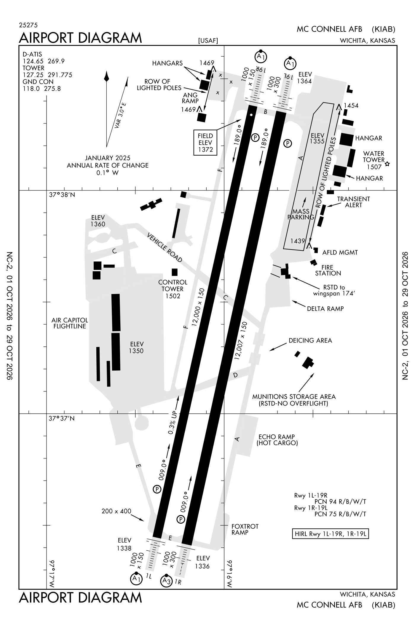
For understanding the field, not for navigation.
| Runway | Length × width | Surface | Lights |
|---|---|---|---|
| 01R/19L | 12,007 × 150 ft | Asphalt, fair | High-intensity lights |
| 01L/19R | 12,000 × 150 ft | Asphalt and concrete | High-intensity lights |
- Runway 01R: PAPI, four lights on the left, short approach lights with alignment lights (SSALR)
- Runway 19L: PAPI, four lights on the left, approach lights with sequenced flashers (ALSF-1)
- Runway 01L: ILS, PAPI, four lights on the left, approach lights with sequenced flashers (ALSF-1)
- Runway 19R: ILS, PAPI, four lights on the left, approach lights with sequenced flashers (ALSF-1)
Radio frequencies
| Digital ATIS | 124.65 | Mc Connell |
| Ground | 118.0 | Mc Connell |
| Tower | 127.25 | Mc Connell |
| Approach West of ict | 126.7 | Mc Connell |
| Approach · Approach and departure · Departure East of iab, 4000 feet and below; 4000 feet and below | 134.8 | Mc Connell |
| Approach · Departure East of iab above 4000 feet; Above 4000 feet | 134.85 | Mc Connell |
| Emergency | 121.5 | Mc Connell |
Aircraft registered in Wichita from the FAA register
1,321 aircraft are registered to owners in Wichita, Kansas: 709 piston singles, 181 turboprops, 178 business jets, 134 gliders, 70 piston twins. Not every one of them is based at this airport; the based-aircraft count above is the FAA's figure for this airport alone.
Companies and organisations in town with two or more aircraft:
Individuals are counted, never named. All aircraft registered in Kansas.
Accidents and incidents at or near this airport NTSB records · 1 since 1982, 0 fatal
Cases the NTSB recorded with this as the nearest airport, newest first. Each opens the full report in plain English. The country as a whole: Where accidents happen.
Nearby within 30 nautical miles
The FAA's remarks as written in the airport file, spelled out
- Prior permission required V962-5271.
- First 1000' concrete; mid 10000' asphalt.
- Mid 9500' grooved.
- Jasu: 4(M32A-86) (MA-1A) (MC-1A) 2(MC-2A) 5(MD-4) 3(AM32-95)
- Fuel: a++
- Oil: O-133-148-156 soap.
- Tran alert: no priority basis. Ltd tran maintenance service available 1300-0500Z++ wkd; 1400-0000Z++ SAT-SUN; closed fed holidays.
- Transient alert: tran maintenance not available outside publ hour. Transient service limited. Weapons/guns, ARM/DE-ARM/SAFEING not available.
- Restricted: inbd aircraft with DV contact comd post 30 minimum prior to eta with block time. Do not ovft munitions stor area 2500' east of midpoint runway 01R-19L. all inbd passenger/cargo aircraft must contact comd post no later than 30 minimum prior to landing.aircraft operates restricted dur bird watch condition moderate (takeoff or landing permissions only when departure and arrival rte avoid ident bird act. No local IFR/VFR traffic pattern act) and severe (takeoff and landing proh WO OG/CC apvl), contact ATIS, tower, comd post, or ptd/amops for current bird watch condition.
- Caution: aircraft may appear to be left of crs when flying inst approach to runway 01L in imc due to parl runway 01R approach light.
- Soap services not available for transient aircraft.
- Tran alert: prk space, svcg, and ron cannot be assured without prior coord dsn 743-3701, C316-759-3701. Gnd svcg not available when lightning within 5 NM.
Connections how this airport links to the rest of the register
- Aircraft registered in Wichita 1,321 aircraft · 709 piston singles, 181 turboprops, 178 business jets
- Textron Aviation INC 344 aircraft in town
- Wingsleasing LLC 117 aircraft in town
- Kansas Aviation Museum 25 aircraft in town
- Columbia Asset Trust CORP Trustee 25 aircraft in town
- NTSB accidents and incidents at or near this airport 1 since 1982 · 0 fatal
- Accidents and incidents in Kansas 1,146 since 1982 · 150 in the last ten years
- Nearby landing places within 30 nautical miles 8 airports, heliports and seaplane bases
- Public-use airports in Kansas 150 landing places
- Kansas 5,752 aircraft registered
These connections as data: /graph/airport/IAB.json · about the eFlight graph.
Facts from the FAA's airport file effective October 1, 2026, written out in plain English; weather from the National Weather Service's aviation weather service; registered aircraft from the FAA register as of October 7, 2026; accidents from the NTSB's public database. Owners are shown only when they are an organisation; no person is named. Check the official sources before a flight: this page is for understanding an airport, not for planning one.