
Campbell Army Airfield (Fort Campbell)
HOP · KHOP · Fort Campbell/Hopkinsville, Kentucky · Christian County · map
Campbell Army Airfield (Fort Campbell) is a private airport owned by the US Army Atca-Aso, 2 miles northwest of Fort Campbell/Hopkinsville, Kentucky, 571 feet above sea level. It has 2 runways; the longest, 05/23, is 10,926 feet of asphalt. It has a control tower and fuel (Jet A with additives).
Private use: permission from the owner is required before landing here.
Weather right now KHOP · observed 4:55 pm CDT (21:55 UTC), 58 minutes ago
VFR good flying weather
- Wind from the southeast (140°) at 4 knots
- Visibility 10 miles or more
- Temperature 82°F (28°C), dew point 37°F (3°C)
- Altimeter 29.96 inHg
The forecast issued Tue 11:00 am CDT (16:00 UTC), good until Wed 5:00 pm CDT (22:00 UTC)
- From Tue 11:00 am CDT (16:00 UTC): wind from the east-northeast at 6 knots, clear skies
The codes as issued (METAR and TAF)
METAR KHOP 062155Z AUTO 14004KT 10SM CLR 28/03 A2996 RMK AO2 SLP145 T02790028
TAF KHOP 061600Z 0616/0722 07006KT 9999 SKC QNH2998INS TX27/0620Z TN11/0711Z
From the National Weather Service's aviation weather service, refreshed every few minutes; times are local to the airport with UTC in brackets. For a flight, get your briefing from Flight Service or an approved provider.
The airport
- Codes
- FAA HOP · ICAO KHOP
- Kind
- Airport · private use, permission required · owned by the Army
- Owner
- US Army Atca-Aso
- Elevation
- 571 feet above sea level
- Control tower
- A control tower with approach control · around the clock
- Attended
- around the clock
- Lights
- runway lights sunset to sunrise; beacon sunset to sunrise
- Fuel
- Jet A with additives
- Notes
- customs available
- On the chart
- St Louis sectional
- Magnetic variation
- 1W
Runways 2
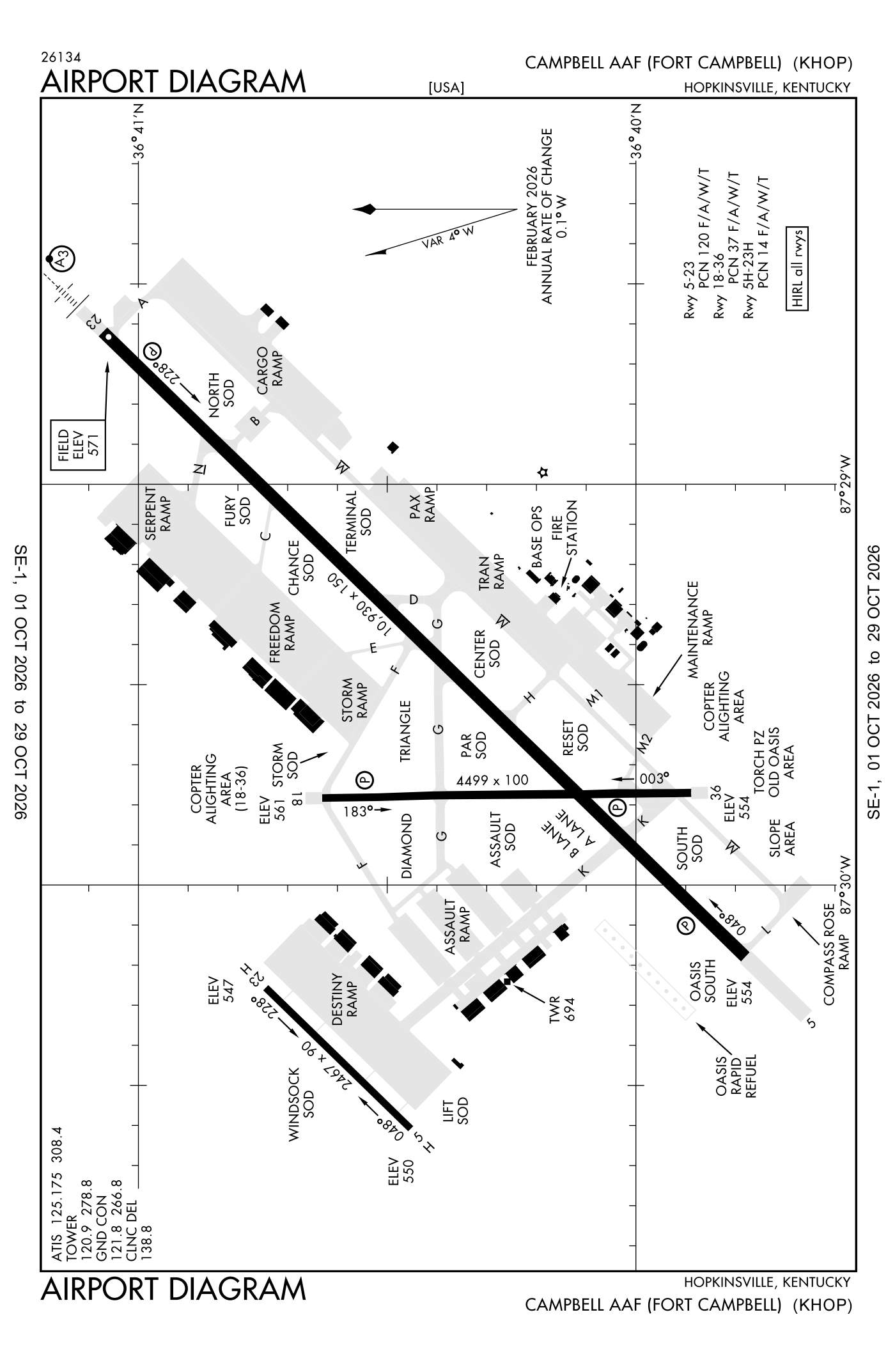
For understanding the field, not for navigation.
| Runway | Length × width | Surface | Lights |
|---|---|---|---|
| 05/23 | 10,926 × 150 ft | Asphalt | High-intensity lights |
| 18/36 | 4,500 × 100 ft | Asphalt | High-intensity lights |
- Runway 05: PAPI, four lights on the left
- Runway 23: ILS with DME, PAPI, four lights on the left, short approach lights with alignment lights (SSALR), right-hand traffic pattern
- Runway 18: PAPI, four lights on the left
- Runway 36: PAPI, four lights on the left
Radio frequencies
| Common traffic advisory (CTAF) | 122.95 | |
| ATIS (recorded airport information) | 125.175 | Campbell |
| Clearance delivery | 138.8 | Campbell |
| Ground | 121.8 | Campbell |
| Tower | 120.9 | Campbell |
| Approach and departure | 118.1 | Campbell |
| Approach and departure | 134.35 | Sabre |
| Emergency | 121.5 | Campbell |
| Pre-taxi clearance Khop base operations | 130.65 | Campbell |
| Pre-taxi clearance Khop base operations | 142.9 | Campbell |
Aircraft registered in Fort Campbell/Hopkinsville from the FAA register
No aircraft on the register list Fort Campbell/Hopkinsville, KY as the owner's town.
Accidents and incidents at or near this airport NTSB records
No NTSB accident or incident records name this airport.
Nearby within 30 nautical miles
The FAA's remarks as written in the airport file
- Cstms/agricultural/img: available 72 hour prior permission required; military aircraft only - D635-7146.
- See flip AP/1 flight haz and supplementary airport rmk.
- Oil: O-123-128-148-156 SP
- Fleet service not available.
- Ctn: pje; R3701 and small arms range 1000 YD from departure end runway 23; deer haz.
- Base operations H24 - dsn 635-7146/7147/C270-798-7146/47.
- Jasu: 3(M-32A-86) 3(AM32-95) 1(MC-2A)
- Transient aircraft shut down, required service or storm ramp parking prior permission required. Fixed wing freedom and serpent ramp aces or parking NA.
- Weather fcst or obs H24 - eagle con.
- Restricted: prior permission required rqr for all tran aircraft shutting down and/or required service or storm ramp prk. No F/west access/taxi/prk freedom/serpent ramps. Taxiway K R/west only north of runway 05-23. Taxiway F and G R/west only west of runway 18-36.
- Bach helicopter approach hdg 155 degrees; departure hdg 335 degrees; contact approach on 118.1; VFR only. Ltd use by air ambulance avoid ovft of hosp, wilson theater, garrison HQ, housing area and schools. Pcl vhf 122.8.
- Navaid: hxw tacan and FK NDB unmnt 0400-1400Z++.
Facts from the FAA's airport file effective October 1, 2026, written out in plain English; weather from the National Weather Service's aviation weather service; registered aircraft from the FAA register as of October 5, 2026; accidents from the NTSB's public database. Owners are shown only when they are an organisation; no person is named. Check the official sources before a flight: this page is for understanding an airport, not for planning one.