
Cannon Air Force Base
CVS · KCVS · Clovis, New Mexico · Curry County · map
Cannon Air Force Base is a private airport, 5 miles west of Clovis, New Mexico, 4,295 feet above sea level. It has 2 runways; the longest, 04/22, is 10,003 feet of concrete. It has a control tower and fuel (Jet A, Jet A with additives).
Private use: permission from the owner is required before landing here.
Weather right now KCVS · observed 3:55 pm MDT (21:55 UTC), 58 minutes ago
VFR good flying weather
- Wind from the south-southwest (210°) at 5 knots
- Visibility 10 miles or more
- Temperature 80°F (27°C), dew point 46°F (8°C)
- Altimeter 30.06 inHg
The forecast issued Tue 12:00 pm MDT (18:00 UTC), good until Wed 6:00 pm MDT (00:00 UTC)
- From Tue 12:00 pm MDT (18:00 UTC): wind from the west-southwest at 12 knots, clear skies
- Changing between Tue 3:00 pm MDT (21:00 UTC) and 4:00 pm MDT (22:00 UTC) to: wind light and variable, clear skies
The codes as issued (METAR and TAF)
METAR KCVS 062155Z AUTO 21005KT 10SM CLR 27/08 A3006 RMK AO2 SLP124 T02680078 $
TAF KCVS 061800Z 0618/0724 24012KT 9999 SKC QNH3006INS BECMG 0621/0622 VRB06KT 9999 SKC QNH3007INS TX28/0620Z TN13/0712Z
From the National Weather Service's aviation weather service, refreshed every few minutes; times are local to the airport with UTC in brackets. For a flight, get your briefing from Flight Service or an approved provider.
The airport
- Codes
- FAA CVS · ICAO KCVS
- Kind
- Airport · private use, permission required · owned by the Air Force
- Elevation
- 4,295 feet above sea level
- Control tower
- A control tower with radar approach control · around the clock
- Attended
- around the clock
- Lights
- runway lights sunset to sunrise; beacon sunset to sunrise
- Fuel
- Jet A, Jet A with additives
- Repairs
- airframe: major repairs; engine: major repairs
- On the chart
- Albuquerque sectional
- Magnetic variation
- 7E
- In the FAA's files since
- November 1938
Runways 2
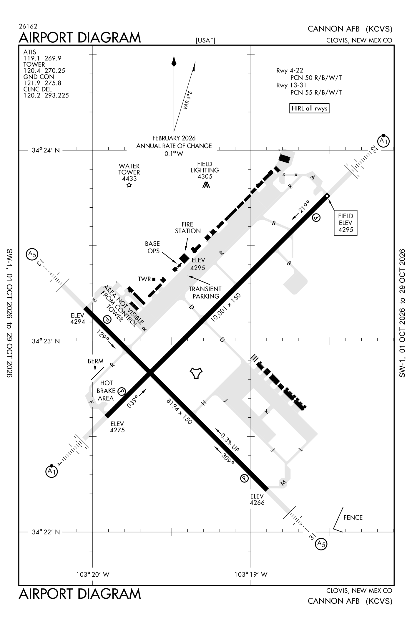
For understanding the field, not for navigation.
| Runway | Length × width | Surface | Lights |
|---|---|---|---|
| 04/22 | 10,003 × 150 ft | Concrete | High-intensity lights |
| 13/31 | 8,196 × 150 ft | Partially concrete | High-intensity lights |
- Runway 04: localizer and glideslope, PAPI, four lights on the left, approach lights with sequenced flashers (ALSF-1)
- Runway 22: localizer and glideslope, PAPI, four lights on the left, approach lights with sequenced flashers (ALSF-1)
- Runway 13: localizer and glideslope, PAPI, four lights on the left, short approach lights with alignment lights (SSALR)
- Runway 31: localizer and glideslope, PAPI, four lights on the left, short approach lights with alignment lights (SSALR)
Radio frequencies
| ATIS (recorded airport information) | 119.1 | Cannon |
| Clearance delivery | 119.0 | |
| Clearance delivery | 120.2 | Cannon |
| Ground | 121.9 | Cannon |
| Tower | 120.4 | Cannon |
| Approach and departure | 118.425 | Cannon |
| Emergency | 121.5 | Cannon |
| Sfa | 139.3 | Cannon |
Aircraft registered in Clovis from the FAA register
80 aircraft are registered to owners in Clovis, New Mexico: 42 piston singles, 14 turboprops, 14 business jets, 5 helicopters, 4 piston twins. Not every one of them is based at this airport; the based-aircraft count above is the FAA's figure for this airport alone.
Companies and organisations in town with two or more aircraft:
Individuals are counted, never named. All aircraft registered in New Mexico.
Accidents and incidents at or near this airport NTSB records
No NTSB accident or incident records name this airport.
Nearby within 30 nautical miles
The FAA's remarks as written in the airport file
- Abandoned unsvc until further notice.
- VFR jet rectangular 5800 feet, tran jet overhead 5800 feet.
- Shoulder pavement distressed alg both sides entr length.
- 20 feet irrigation eqpt located 2000 feet from both runway ends. Psbl hydroplaning mid asphalt portion. Paved shoulders NA; 1-5 in vert edge alg both sides entire length.
- 1400 feet non-standard length.
- 1482 feet non-standard length.
- 15 feet veh on road 1200 feet from runway end. 1ST 1200 feet surface rough concrete.
- 1ST 1200 feet both ends concrete; mid 5800 feet asphalt concrete.
- Ctn: bird haz; sewage lagoon and lake 1/2 NM southeast of runway 22.
- Departure restricted to 5300 feet until der.
- Service: gated threshold light on runway 04/22.
- Ctn: Clovis regional 13 NM northeast; portales municipal 14 NM ssw.
Facts from the FAA's airport file effective October 1, 2026, written out in plain English; weather from the National Weather Service's aviation weather service; registered aircraft from the FAA register as of October 5, 2026; accidents from the NTSB's public database. Owners are shown only when they are an organisation; no person is named. Check the official sources before a flight: this page is for understanding an airport, not for planning one.