
MC Guire Field (Joint Base MC Guire Dix Lakehurst)
WRI · KWRI · Wrightstown, New Jersey · Burlington County · map
MC Guire Field (Joint Base MC Guire Dix Lakehurst) is a private airport owned by Usaf Jb Mcguire Dix Lakehurst, 2 miles southeast of Wrightstown, New Jersey, 140 feet above sea level. It has 2 runways; the longest, 06/24, is 11,451 feet of asphalt and concrete. It has a control tower.
Private use: permission from the owner is required before landing here.
Weather right now KWRI · observed 6:43 pm EDT (22:43 UTC), 22 minutes ago
IFR instrument conditions
- Wind from the east (100°) at 12 knots
- Visibility 10 miles or more
- Sky: overcast at 900 feet
- Weather: light rain
- Temperature 61°F (16°C), dew point 59°F (15°C)
- Altimeter 29.87 inHg
The forecast issued Sun 2:00 pm EDT (18:00 UTC), good until Mon 8:00 pm EDT (00:00 UTC)
- From Sun 2:00 pm EDT (18:00 UTC): wind from the east at 15 knots, gusting to 25, light rain, mist, a broken layer at 600 feet, overcast at 1,500 feet IFR
- Changing between Sun 6:00 pm EDT (22:00 UTC) and 7:00 pm EDT (23:00 UTC) to: wind from the northeast at 10 knots, gusting to 15, light rain, mist, a broken layer at 500 feet, overcast at 1,000 feet IFR
- At times between Sun 9:00 pm EDT (01:00 UTC) and 1:00 am EDT (05:00 UTC): thunderstorms nearby, a broken layer at 500 feet (thunderheads) IFR
- Changing between Mon 5:00 am EDT (09:00 UTC) and 6:00 am EDT (10:00 UTC) to: wind from the north-northeast at 12 knots, gusting to 18, a broken layer at 800 feet, overcast at 2,000 feet IFR
- At times between Mon 8:00 am EDT (12:00 UTC) and 11:00 am EDT (15:00 UTC): wind from the north at 15 knots, gusting to 25
- Changing between Mon 10:00 am EDT (14:00 UTC) and 11:00 am EDT (15:00 UTC) to: wind from the north-northwest at 10 knots, a broken layer at 1,000 feet, overcast at 3,000 feet MVFR
The codes as issued (METAR and TAF)
SPECI KWRI 112243Z 10012KT 10SM -RA OVC009 16/15 A2987 RMK AO2A RAB2155E2157DZB2157E01RAB01E38RAB43 CIG 005 RWY06 SLP114 $
TAF KWRI 111800Z 1118/1224 09015G25KT 4800 -RA BR BKN006 OVC015 QNH3010INS BECMG 1122/1123 05010G15KT 6000 -RA BR BKN005 OVC010 QNH2990INS TEMPO 1201/1205 VCTS BKN005CB BECMG 1209/1210 03012G18KT 9999 NSW BKN008 OVC020 QNH2974INS TEMPO 1212/1215 01015G25KT BECMG 1214/1215 33010KT 9999 BKN010 OVC030 QNH2982INS TX18/1120Z TN14/1210Z
From the National Weather Service's aviation weather service, refreshed every few minutes; times are local to the airport with UTC in brackets. For a flight, get your briefing from Flight Service or an approved provider.
The airport
- Codes
- FAA WRI · ICAO KWRI
- Kind
- Airport · private use, permission required · owned by the Air Force
- Owner
- Usaf Jb Mcguire Dix Lakehurst
- Elevation
- 140 feet above sea level
- Control tower
- A control tower with radar approach control · around the clock
- Attended
- around the clock
- Lights
- beacon sunset to sunrise
- Fuel and services
- no fuel reported; the services card below
- On the chart
- New York sectional
- Magnetic variation
- 12W
- In the FAA's files since
- February 1938
Runways 2
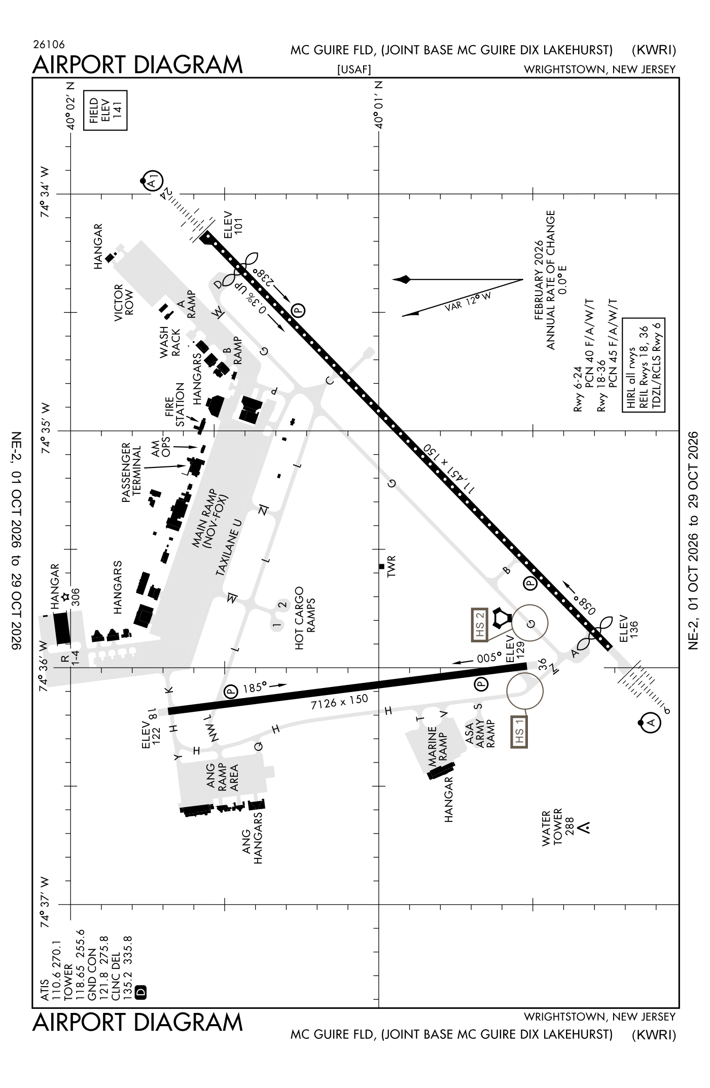
For understanding the field, not for navigation.
| Runway | Length × width | Surface | Lights |
|---|---|---|---|
| 06/24 | 11,451 × 150 ft | Asphalt and concrete | High-intensity lights |
| 18/36 | 7,126 × 150 ft | Concrete | High-intensity lights |
- Runway 06: ILS, PAPI, four lights on the left, approach lights with sequenced flashers (ALSF-2), threshold displaced 442 ft, 11,009 ft available for landing
- Runway 24: localizer and glideslope, PAPI, four lights on the left, approach lights with sequenced flashers (ALSF-1), right-hand traffic pattern, threshold displaced 995 ft, 10,456 ft available for landing
- Runway 18: PAPI, four lights on the left, right-hand traffic pattern
- Runway 36: PAPI, four lights on the left
Radio frequencies
| Digital ATIS | 110.6 | Mc Guire |
| Clearance delivery | 126.15 | |
| Clearance delivery | 135.2 | Mc Guire |
| Ground | 121.8 | Mc Guire |
| Tower | 118.65 | Mc Guire |
| Approach and departure · Harrisburg and star · Waalk and star | 126.475 | Mc Guire |
| Emergency | 121.5 | Mc Guire |
| Comd and post | 134.1 | Mc Guire |
Aircraft registered in Wrightstown from the FAA register
3 aircraft are registered to owners in Wrightstown, New Jersey: 3 piston singles. Not every one of them is based at this airport; the based-aircraft count above is the FAA's figure for this airport alone.
Individuals are counted, not named (the site's policy at this time). All aircraft registered in New Jersey.
Fuel and services as reported to the FAA
- Fuel
- none reported
- Repairs
- airframe and engine: major repairs
- Parking
- hangars
- Oxygen
- bulk oxygen (high- and low-pressure)
- Also here
- cargo handling
Nearest fields reporting jet fuel: Flying W Airport (11 nm southwest), South Jersey Regional (13 nm west), Ocean County (15 nm east), Trenton Mercer Airport (19 nm northwest).
Nearest fields reporting avgas: Flying W Airport (11 nm southwest), Trenton-Robbinsville Airport (12 nm north), South Jersey Regional (13 nm west), Ocean County (15 nm east).
The FAA's file records what is sold and done at the field, as the airport manager reports it, not who sells it or the price; fuel sellers (FBOs) are not named in any public file. Airports selling jet fuel in New Jersey · avgas.
Accidents and incidents at or near this airport NTSB records · 3 since 1982, 1 fatal
Cases the NTSB recorded with this as the nearest airport, newest first. Each opens the full report in plain English. The country as a whole: Where accidents happen.
Nearby within 30 nautical miles
The FAA's remarks as written in the airport file, spelled out
- Service: aoe.
- Pattern altitude for helicopter 600 feet; light aircraft 800 feet; rectangular 1600 feet; ohd 2100 feet.
- Runway 06/24 under runs available for departure.
- Power line 45 feet HI and 3/4 MI from approach end 18.
- 1000 feet of runway 06-24 are grooved concrete; remainder of runway grooved asphalt. Runway 06-24 has hardened, NON-GROOVED ovrn.
- Runway 18/36 only has 200 feet paved asphalt NON-GROOVED ovrn, remainder of runway not grooved.
- Jasu: (C26) (MD-3) 6(MA-1A) (MA-1).
- Fuel: a++
- Fluid: SP presair lhox lox (C-5, KC-10, 747 DE-ICING ltd to WG only. 3 hour PN rqr.)
- Oil: O-128-133-148-156.
- Tran alert: service available H24 daily.
- Misc: all tran aircraft rqr prior permission required. Required apvl through afld mgmt operations dsn 650-2714, C609-754-2714; prior permission requireds will be required no earlier than seven days, and no later than 24 hour prior to arrival, 48 hour for aircraft carrying dangerous/haz cargo. Aircrews with apv prior permission required that deviate from coord arrival time by more than one hour must notify amops asap. If no notification rcvd after one hour, prior permission required will be terminated.
Connections how this airport links to the rest of the register
- Aircraft registered in Wrightstown 3 aircraft · 3 piston singles
- NTSB accidents and incidents at or near this airport 3 since 1982 · 1 fatal
- Accidents and incidents in New Jersey 1,187 since 1982 · 135 in the last ten years
- Nearby landing places within 30 nautical miles 8 airports, heliports and seaplane bases
- Public-use airports in New Jersey 40 landing places
- New Jersey 3,024 aircraft registered
The whole map of how records connect · these connections as data: /graph/airport/WRI.json.
Facts from the FAA's airport file effective October 1, 2026, written out in plain English; weather from the National Weather Service's aviation weather service; registered aircraft from the FAA register as of October 9, 2026; accidents from the NTSB's public database. Owners are shown only when they are an organisation; no person is named. Check the official sources before a flight: this page is for understanding an airport, not for planning one.