
Fairchild Air Force Base
SKA · KSKA · Spokane, Washington · Spokane County · map
Fairchild Air Force Base is a private airport owned by Usaf, 10 miles southwest of Spokane, Washington, 2,462 feet above sea level. Its one runway, 05/23, is 13,899 feet of concrete. It has a control tower.
Private use: permission from the owner is required before landing here.
Weather right now KSKA · observed 3:55 pm PDT (22:55 UTC), 39 minutes ago
VFR good flying weather
- Wind from the west (270°) at 3 knots
- Visibility 10 miles or more
- Temperature 74°F (23°C), dew point 35°F (1°C)
- Altimeter 30.11 inHg
The forecast issued Tue 12:00 pm PDT (19:00 UTC), good until Wed 6:00 pm PDT (01:00 UTC)
- From Tue 12:00 pm PDT (19:00 UTC): wind from the southeast at 6 knots, a few clouds at 20,000 feet
- Changing between Tue 2:00 pm PDT (21:00 UTC) and 3:00 pm PDT (22:00 UTC) to: wind from the southwest at 9 knots, scattered clouds at 15,000 feet
- Changing between Tue 6:00 pm PDT (01:00 UTC) and 7:00 pm PDT (02:00 UTC) to: wind light and variable, a few clouds at 15,000 feet
The codes as issued (METAR and TAF)
METAR KSKA 062255Z 27003KT 10SM CLR 23/01 A3011 RMK AO2A SLP187 T02310014 $
TAF KSKA 061900Z 0619/0801 13006KT 9999 FEW200 QNH3008INS BECMG 0621/0622 23009KT 9999 SCT150 QNH3007INS BECMG 0701/0702 VRB06KT 9999 FEW150 QNH3006INS TX23/0623Z TN04/0714Z
From the National Weather Service's aviation weather service, refreshed every few minutes; times are local to the airport with UTC in brackets. For a flight, get your briefing from Flight Service or an approved provider.
The airport
- Codes
- FAA SKA · ICAO KSKA
- Kind
- Airport · private use, permission required · owned by the Air Force
- Owner
- Usaf
- Elevation
- 2,462 feet above sea level
- Control tower
- A control tower · around the clock
- Attended
- around the clock
- Lights
- beacon sunset to sunrise
- Repairs
- airframe: major repairs; engine: major repairs
- Notes
- customs available
- On the chart
- Seattle sectional
- Magnetic variation
- 16E
- In the FAA's files since
- December 1948
Runway
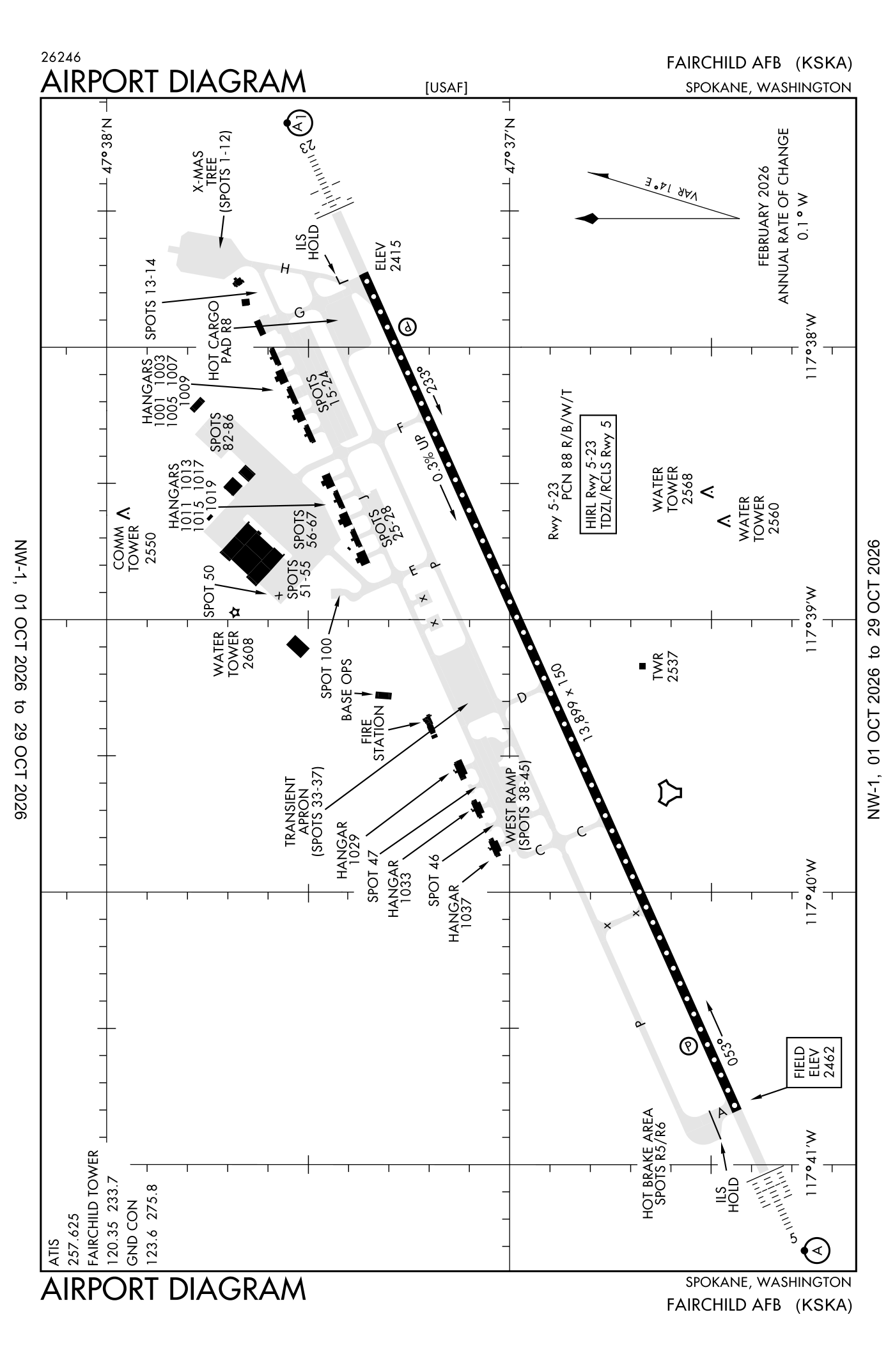
For understanding the field, not for navigation.
| Runway | Length × width | Surface | Lights |
|---|---|---|---|
| 05/23 | 13,899 × 150 ft | Concrete | High-intensity lights |
- Runway 05: localizer and glideslope, PAPI, four lights on the left, approach lights with sequenced flashers (ALSF-2)
- Runway 23: localizer and glideslope, PAPI, four lights on the left, approach lights with sequenced flashers (ALSF-1), right-hand traffic pattern
Radio frequencies
| Ground | 123.6 | Fairchild |
| Tower | 120.35 | Fairchild |
| Approach and departure · Class C airspace · Zoomr and star arriving from headings 205 to 025 | 123.75 | Fairchild |
| Approach and departure · Class C airspace · Hilie and star arriving from headings 026 to 204 | 133.35 | Fairchild |
| Emergency | 121.5 | Fairchild |
| Pre-taxi clearance | 139.3 | Fairchild |
Aircraft registered in Spokane from the FAA register
287 aircraft are registered to owners in Spokane, Washington: 236 piston singles, 10 turboprops, 10 piston twins, 9 helicopters, 9 gliders. Not every one of them is based at this airport; the based-aircraft count above is the FAA's figure for this airport alone.
Companies and organisations in town with two or more aircraft:
Individuals are counted, never named. All aircraft registered in Washington.
Accidents and incidents at or near this airport NTSB records · 2 since 1982, 1 fatal
Cases the NTSB recorded with this as the nearest airport, newest first. Each opens the full report in plain English.
Nearby within 30 nautical miles
The FAA's remarks as written in the airport file
- Rectangular 4000 feet, overhead 4500 feet.
- Jasu: (MA-1A) (A/M32A-86) (MC-1A).
- Fuel: J8, a++
- Fluid: SP presair; DE-ICE available for C5 and C17 type aircraft; lox available upon required; rqr 3 duty days PN.
- Oil: O-148-156 joap.
- Caution: do not mistake Spokane international 4.5 NM east of Fairchild Afb. Phase II (the high bird potential haz time period) of the bash program is in effect. Exp increased bird act (approx) APR-MAY and NOV-DEC; review or check NOTAM for current bash phase.
- Ang: dagger operations is open 24/7. Prior permission required for ang ramp, dsn 370-7100/7133.
- Sfa remarks: aircraft rqr sfa notify seattle center or app 20 minimum out on any publ frequency.
- Runway 05/23 ST175 weight thsd pounds.
- Pad 5 DZ, 5000' south of runway effective 1630-2130Z++ MON-FRI.
- Caution: unctl veh on taxiways and ramps. Copter operations within vicinity of Fairchild Afb.
- Caution: flare rocket frng and demolition of explosives training Wednesday 1530-1630Z++ and 2000-2100Z++ located 5,000 feet south runway 5-23 abm taxiway F, maximum altitude 1300 feet.
Facts from the FAA's airport file effective October 1, 2026, written out in plain English; weather from the National Weather Service's aviation weather service; registered aircraft from the FAA register as of October 5, 2026; accidents from the NTSB's public database. Owners are shown only when they are an organisation; no person is named. Check the official sources before a flight: this page is for understanding an airport, not for planning one.