
Oceana Naval Air Station (Apollo Soucek Field)
NTU · KNTU · Virginia Beach, Virginia · Virginia Beach County · map
Oceana Naval Air Station (Apollo Soucek Field) is a private airport owned by the U.S. Navy, 3 miles southwest of Virginia Beach, Virginia, 22 feet above sea level. It has 4 runways; the longest, 05R/23L, is 12,001 feet of partially concrete. It has a control tower.
Private use: permission from the owner is required before landing here.
Weather right now KNTU · observed 7:56 pm EDT (23:56 UTC), 35 minutes ago
VFR good flying weather
- Wind calm
- Visibility 10 miles or more
- Temperature 56°F (13°C), dew point 47°F (8°C)
- Altimeter 30.10 inHg
The forecast issued Tue 6:00 pm EDT (22:00 UTC), good until Wed 7:00 pm EDT (23:00 UTC)
- From Tue 7:00 pm EDT (23:00 UTC): wind light and variable, clear skies
- From Wed 12:00 pm EDT (16:00 UTC): wind from the southeast at 7 knots, a few clouds at 4,000 feet
The codes as issued (METAR and TAF)
METAR KNTU 062356Z 00000KT 10SM CLR 13/08 A3010 RMK AO2 SLP196 T01330083 10194 20133 55002
TAF KNTU 062200Z 0623/0723 VRB05KT 9999 SKC QNH3000INS FM071600 13007KT 9999 FEW040 QNH2994INS TX21/0719Z TN10/0710Z FN20010
From the National Weather Service's aviation weather service, refreshed every few minutes; times are local to the airport with UTC in brackets. For a flight, get your briefing from Flight Service or an approved provider.
The airport
- Codes
- FAA NTU · ICAO KNTU
- Kind
- Airport · private use, permission required · owned by the Navy
- Owner
- U.S. Navy
- Elevation
- 22 feet above sea level
- Control tower
- A control tower with radar approach control · around the clock
- Attended
- around the clock
- Lights
- runway lights see the remarks below; beacon sunset to sunrise
- On the chart
- Washington sectional
- Magnetic variation
- 10W
- In the FAA's files since
- August 1943
Runways 4
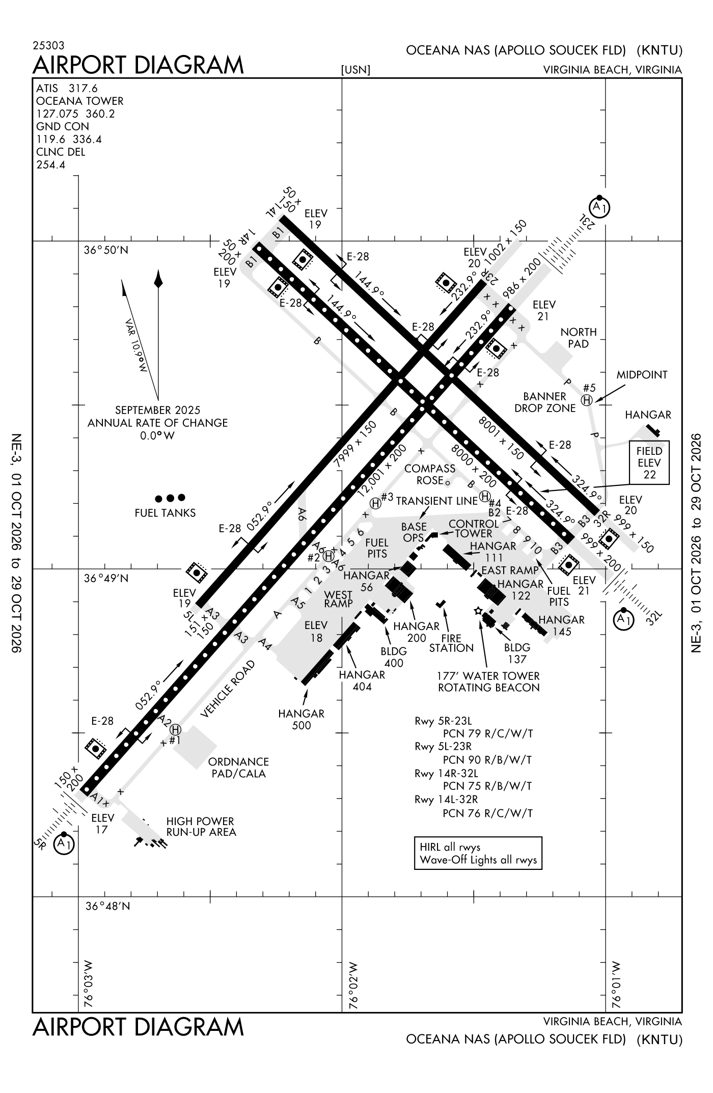
For understanding the field, not for navigation.
| Runway | Length × width | Surface | Lights |
|---|---|---|---|
| 05R/23L | 12,001 × 200 ft | Partially concrete, good | High-intensity lights |
| 14L/32R | 8,001 × 150 ft | Partially concrete, good | High-intensity lights |
| 05L/23R | 8,000 × 150 ft | Partially concrete, good | High-intensity lights |
| 14R/32L | 8,000 × 200 ft | Partially concrete, good | High-intensity lights |
- Runway 05R: approach lights with sequenced flashers (ALSF-1)
- Runway 23L: approach lights with sequenced flashers (ALSF-1)
- Runway 32L: approach lights with sequenced flashers (ALSF-1)
Radio frequencies
| Ground | 119.6 | Oceana |
| Tower | 127.075 | Oceana |
| Approach · Approach and departure | 123.9 | Oceana |
| Emergency | 121.5 | Oceana |
| Kohls and star · Outla and star | 118.9 | Oceana |
Automated weather (ASOS), by phone DSN 433-3619.
Aircraft registered in Virginia Beach from the FAA register
326 aircraft are registered to owners in Virginia Beach, Virginia: 231 piston singles, 44 piston twins, 17 business jets, 11 turboprops, 11 helicopters. Not every one of them is based at this airport; the based-aircraft count above is the FAA's figure for this airport alone.
Companies and organisations in town with two or more aircraft:
Individuals are counted, never named. All aircraft registered in Virginia.
Accidents and incidents at or near this airport NTSB records · 2 since 1982, 1 fatal
Cases the NTSB recorded with this as the nearest airport, newest first. Each opens the full report in plain English.
Nearby within 30 nautical miles
The FAA's remarks as written in the airport file
- SERVICE-A-GEAR: A-G nml rigged all runway except inboard runway shortfield arresting gear.
- Available only during hours of operation.
- Hook E28(B) (1476 feet).
- Hook E28(B) (1412 feet).
- Hook E28(B) (1461 feet).
- Hook E28(B) (1414 feet).
- Hook E28(B) (1435 feet).
- Hook E28(B) (1506 feet).
- Hook E28(B) (1454 feet).
- Hook E28(B) (1476 feet).
- Ols.
- Also ols.
Facts from the FAA's airport file effective October 1, 2026, written out in plain English; weather from the National Weather Service's aviation weather service; registered aircraft from the FAA register as of October 5, 2026; accidents from the NTSB's public database. Owners are shown only when they are an organisation; no person is named. Check the official sources before a flight: this page is for understanding an airport, not for planning one.