
Minot Air Force Base
MIB · KMIB · Minot, North Dakota · Ward County · map
Minot Air Force Base is a private airport owned by Usaf, 10 miles north of Minot, North Dakota, 1,666 feet above sea level. Its one runway, 12/30, is 13,198 feet of asphalt and concrete. It has a control tower.
Private use: permission from the owner is required before landing here.
Weather right now KMIB · observed 5:55 pm CDT (22:55 UTC), 36 minutes ago
VFR good flying weather
- Wind from the north-northwest (340°) at 13 knots
- Visibility 10 miles or more
- Temperature 68°F (20°C), dew point 41°F (5°C)
- Altimeter 29.87 inHg
The forecast issued Tue 12:00 pm CDT (17:00 UTC), good until Wed 6:00 pm CDT (23:00 UTC)
- From Tue 12:00 pm CDT (17:00 UTC): wind from the north at 10 knots, gusting to 20, a few clouds at 5,000 feet
- Changing between Tue 8:00 pm CDT (01:00 UTC) and 9:00 pm CDT (02:00 UTC) to: wind from the west at 9 knots, a few clouds at 10,000 feet
- Changing between Wed 7:00 am CDT (12:00 UTC) and 8:00 am CDT (13:00 UTC) to: wind from the west-northwest at 10 knots, gusting to 20, a few clouds at 20,000 feet
- Changing between Wed 10:00 am CDT (15:00 UTC) and 11:00 am CDT (16:00 UTC) to: wind from the west-northwest at 15 knots, gusting to 25, a few clouds at 15,000 feet
The codes as issued (METAR and TAF)
METAR KMIB 062255Z 34013KT 10SM CLR 20/05 A2987 RMK AO2A SLP122 T02000052 $
TAF KMIB 061700Z 0617/0723 36010G20KT 9999 FEW050 QNH2983INS BECMG 0701/0702 28009KT 9999 FEW100 QNH2992INS BECMG 0712/0713 29010G20KT 9999 FEW200 QNH2996INS BECMG 0715/0716 29015G25KT 9999 FEW150 QNH2998INS TX21/0621Z TN08/0710Z
From the National Weather Service's aviation weather service, refreshed every few minutes; times are local to the airport with UTC in brackets. For a flight, get your briefing from Flight Service or an approved provider.
The airport
- Codes
- FAA MIB · ICAO KMIB
- Kind
- Airport · private use, permission required · owned by the Air Force
- Owner
- Usaf
- Elevation
- 1,666 feet above sea level
- Control tower
- A control tower with radar approach control · operates 24 hours from 1200z++ monday through 0400z++ friday. saturday and sunday 1500-2300z++.
- Attended
- every day, monday to friday; every day, saturday &sun
- Lights
- beacon sunset to sunrise
- Repairs
- airframe: major repairs; engine: major repairs
- On the chart
- Billings sectional
- Magnetic variation
- 7E
Runway
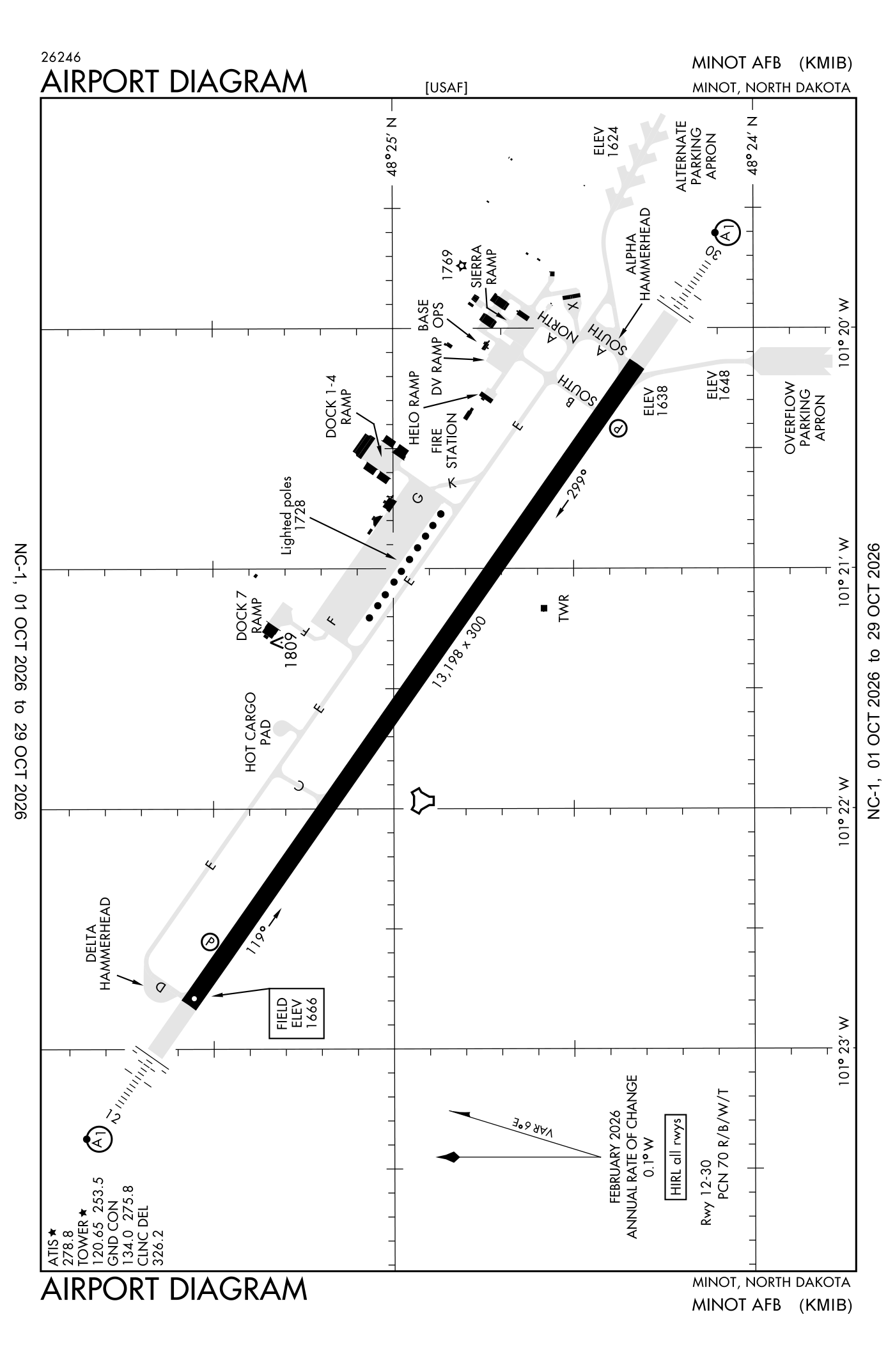
For understanding the field, not for navigation.
| Runway | Length × width | Surface | Lights |
|---|---|---|---|
| 12/30 | 13,198 × 300 ft | Asphalt and concrete | High-intensity lights |
- Runway 12: localizer and glideslope, PAPI, four lights on the left, approach lights with sequenced flashers (ALSF-1)
- Runway 30: ILS, PAPI, four lights on the left, approach lights with sequenced flashers (ALSF-1), right-hand traffic pattern
Radio frequencies
| Ground | 134.0 | Minot |
| Tower | 120.65 | Minot |
| Approach | 118.15 | Minot |
| Approach and departure | 119.6 | Minot |
| Emergency | 121.5 | Minot |
Aircraft registered in Minot from the FAA register
238 aircraft are registered to owners in Minot, North Dakota: 127 piston singles, 94 drones, 7 piston twins, 5 turboprops, 2 helicopters. Not every one of them is based at this airport; the based-aircraft count above is the FAA's figure for this airport alone.
Companies and organisations in town with two or more aircraft:
Individuals are counted, never named. All aircraft registered in North Dakota.
Accidents and incidents at or near this airport NTSB records
No NTSB accident or incident records name this airport.
Nearby within 30 nautical miles
The FAA's remarks as written in the airport file
- Operates 1300-0500Z++ MON-THUR; 1300-2400Z++ Friday; closed Saturday, Sunday, afgsc approved down days, and federal holidays except by NOTAM.
- Other times by NOTAM.
- Actual surface type is "pem" (part asphalt/concrete/macadam).
- Jasu: 9(MD-3A) 2(M32A-60A) (MA-1A)
- Fluid: SP presair DE-ICE-EXP possible delay wkend. Lox lhox lhnit
- Oil: O-133-148 joap - rqr 2 hour PN wkend.
- Tran alert: operates 1330-2330Z++ wkd; closed Saturday and Sunday. Fleet service unavailable.
- Caution: bird haz.
- Traffic pattern: rectangular 2900', MULTI-ENG jet right traffic runway 30; overhead 3400', right break runway 12.
- Cstms/agricultural/img: cstms available for aircraft arrival FR foreign areas, incl rqr in rmk sec of flight plan and reconfirm not later than 30 minimum prior to arrival on ptd. Incl a passenger breakdown by total NR of U.S. military and U.S. civil on board, when applicable.
- Restricted: avoid ovft below 4200' of afld when closed, excld publ inst approach of departure pro.
- Caution: bash phase II effective 1 apr to 15 jun and 1 sep to 30 nov. CK current NOTAMs for any deviations to the bash phase windows.
Facts from the FAA's airport file effective October 1, 2026, written out in plain English; weather from the National Weather Service's aviation weather service; registered aircraft from the FAA register as of October 5, 2026; accidents from the NTSB's public database. Owners are shown only when they are an organisation; no person is named. Check the official sources before a flight: this page is for understanding an airport, not for planning one.