
New Castle Airport
ILG · KILG · Wilmington, Delaware · New Castle County · map
New Castle Airport is a public-use airport owned by Delaware River & Bay Authority, 4 miles south of Wilmington, Delaware, 80 feet above sea level. It has 3 runways; the longest, 09/27, is 7,275 feet of asphalt. It has a control tower, fuel (100LL avgas, Jet A) and about 219 general-aviation aircraft based on the field by the FAA's count. The receiver network heard 4 different aircraft arrive or depart here in the last seven days. The FAA counts about 47,150 takeoffs and landings a year. About 133,946 passengers boarded flights here in the FAA's fiscal year 2024.
Quick answers answers refresh every morning
What is the airport code for New Castle Airport?
Its FAA code is ILG, and its ICAO code is KILG.
Where is New Castle Airport?
It is 4 miles south of Wilmington, Delaware, 80 feet above sea level.
How long is the longest runway at New Castle Airport?
The longest of its 3 runways, 09/27, is 7,275 feet long.
Does New Castle Airport have a control tower?
Yes, it has a control tower.
What fuel can you buy at New Castle Airport?
The FAA's airport file lists 100LL avgas, Jet A.
Where can you fly nonstop from New Castle Airport?
Airline flights go to 8 airports, the busiest of them Orlando International, Southwest Florida International, Tampa International, Fort Lauderdale/Hollywood International, Luis Munoz Marin International. Every route
Are there flight schools at New Castle Airport?
33 flight schools, flying clubs or college flight programmes are based within about 15 miles of it, including Career Pilot Training LLC and Flight Training Aircraft LLC. Compare them
Where are the nearest FAA examiners to New Castle Airport?
16 pilot examiners and 37 aviation medical examiners work within 50 nautical miles. See them by name
Weather and planning now, the forecast, warnings, pilot reports, winds aloft, restrictions
Fetching the weather now, the forecast, the warnings in force, pilot reports and the winds aloft for New Castle Airport…
Wind map live wind over the area, from Windy.com
Colours show wind speed, the moving lines its direction; drag the time bar for the coming days. Map and forecast by Windy.com.
The airport facts, runways, radio, fuel and services, the FAA's remarks
The airport
- Codes
- FAA ILG · ICAO KILG
- Kind
- Airport · open to the public · publicly owned
- Owner
- Delaware River & Bay Authority
- Elevation
- 80 feet above sea level
- Control tower
- A control tower · 6:30 am to 11:00 pm
- Attended
- around the clock
- Lights
- runway lights see the remarks below; beacon sunset to sunrise
- Fuel and services
- 100LL avgas, Jet A; the services card below
- Notes
- landing fee · certified for airline service (Part 139)
- On the chart
- Washington sectional
- Magnetic variation
- 10W
- In the FAA's files since
- May 1943
Runways 3
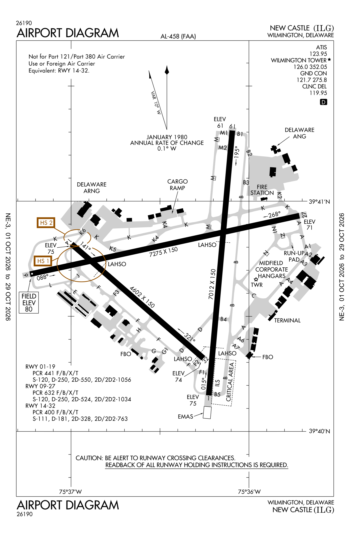
For understanding the field, not for navigation.
| Runway | Length × width | Surface | Lights |
|---|---|---|---|
| 09/27 | 7,275 × 150 ft | Asphalt, fair | High-intensity lights |
| 01/19 | 7,012 × 150 ft | Asphalt, excellent | High-intensity lights |
| 14/32 | 4,602 × 150 ft | Asphalt, fair | Medium-intensity lights |
- Runway 09: PAPI, four lights on the left, 7,000 ft available for landing, trees 49 ft high 1,125 ft from the end
- Runway 27: PAPI, four lights on the left, 7,000 ft available for landing, trees 64 ft high 1,000 ft from the end
- Runway 01: ILS, medium-intensity approach lights with runway alignment lights (MALSR), road 8 ft high 500 ft from the end
- Runway 19: PAPI, four lights on the left, trees 72 ft high 1,240 ft from the end
- Runway 14: trees 43 ft high 720 ft from the end
- Runway 32: VASI, four boxes on the left
Radio frequencies
| Common traffic advisory (CTAF) · Tower | 126.0 | Wilmington |
| UNICOM | 122.95 | |
| ATIS (recorded airport information) · Ilg and automated weather (ASOS) | 123.95 | Wilmington |
| Clearance delivery | 119.95 | Wilmington |
| Ground | 121.7 | Wilmington |
| Approach and departure | 118.35 | Wilmington |
| Emergency | 121.5 | Wilmington |
| Arlft and star | 132.425 | Wilmington |
Automated weather (ASOS), by phone 302-217-3317.
Fuel and services as reported to the FAA
- Fuel
- 100LL avgas, Jet A
- Repairs
- airframe and engine: major repairs
- Parking
- hangars, tie-downs
- Oxygen
- bottled oxygen (high- and low-pressure), bulk oxygen (high- and low-pressure)
- Also here
- air ambulance, avionics, cargo handling, flight instruction, aircraft rental, aircraft sales
- Notes
- landing fee charged
Other fields with jet fuel nearby: Summit Airport (11 nm southwest), Brandywine Regional (19 nm north), Philadelphia International (20 nm northeast).
The FAA's file records what is sold and done at the field, as the airport manager reports it, not who sells it or the price; fuel sellers (FBOs) are not named in any public file. Airports selling jet fuel in Delaware · avgas.
The FAA's remarks as written in the airport file, spelled out
- When tower closed activate approach lights (MALSR) runway 01; runway end identifier lights runway 09, 27 and 19; PAPI runway 09 and 27; high-intensity runway lights runway 01/19 and 09/27; medium-intensity runway lights runway 14/32 - the common traffic frequency.
- Landing fee for all aircraft over 7500 pounds except federal government; military.
- Engineered material arresting system (emas) 303 feet in length by 170 feet in width located at der 19.
- Runway 14/32 not available for part 121/PART 380 operations with schedule passenger carrying operations more than 9 passenger seats and unscheduled passenger carrying operations more than 30 passenger seats. No part 121/PART 380 operations except for tax.
- Runway 14/32 NON-STANDARD military assault landing zone (alz) lighting.
- Birds on and in the vicinity of airport.
- Runway 09/27 no tgl for turbo jet 11:00 pm to 7:00 am.
- Txl G northwest of taxiway H ltd to aircraft with wingspan of 79 feet or less. Txl G section btw taxiway H and taxiway G1 ltd to aircraft with wingspan of 49 feet or less.
- When the control tower closed, pilots must annc intns over the common traffic frequency bfr landings, takeoffs or gnd travel on runways and taxiways.
- Pvt gnd vehicles cross taxiway a between taxiways A4 and C.
- When the control tower closed annc emergencies on the common traffic frequency drctly to rescue and firefighting (ARFF) station.
- Terminal apron closed except air carrier.
Flights and activity in the air now, the airlines, based aircraft, takeoffs and landings
Activity now checking the volunteer receiver network…
Within ten miles
- Looking…
Arrivals and departures, last hour
- Looking…
From the volunteer receiver network, a few minutes behind at most; aircraft whose owners asked the FAA not to be displayed are left out; no person is named. Open the live map here.
Scheduled and charter flights from here the DOT's airline reports · August 2025 to July 2026
Airlines reported 1,356 departures from ILG in those twelve months, carrying 186,552 passengers in 244,551 seats (76% filled), to 56 destinations (3 abroad) on 11 airlines.
| Where to | Flights | Passengers | Airlines |
|---|---|---|---|
| New Castle → Orlando International ILG–MCO | 211 | 30,729 | TEM Enterprises dba ... |
| New Castle → Southwest Florida International ILG–RSW | 170 | 25,465 | TEM Enterprises dba ... |
| New Castle → Tampa International ILG–TPA | 160 | 22,573 | TEM Enterprises dba ... |
| New Castle → Fort Lauderdale/Hollywood International ILG–FLL | 149 | 20,985 | TEM Enterprises dba ... |
| New Castle → Luis Munoz Marin International ILG–SJU | 142 | 21,226 | TEM Enterprises dba ... |
| New Castle → Lakeland Linder International ILG–LAL | 104 | 15,441 | TEM Enterprises dba ... |
| New Castle → Daytona Beach International ILG–DAB | 79 | 10,886 | TEM Enterprises dba ... |
| New Castle → Myrtle Beach International ILG–MYR | 62 | 9,113 | TEM Enterprises dba ... |
All 56 destinations, the airlines and the aircraft, month by month
From the Bureau of Transportation Statistics' T-100 table: every segment an airline reported flying, three months in arrears. Private, business and training flights are not in it; the live picture is in the activity card.
Based aircraft as counted for the FAA, fiscal year 2024
Based aircraft, as a table
| aircraft | |
|---|---|
| single-engine | 94 |
| multi-engine | 26 |
| jets | 74 |
| helicopters | 5 |
| other | 20 |
The FAA's count is the general-aviation aircraft kept on the field (singles, twins, business jets, helicopters) from its Terminal Area Forecast, the latest year with an actual count; airline fleets are never counted as based anywhere, so a big airline airport shows a small number. The aircraft heard arriving or departing are the site's own record from the volunteer receiver network, airliners included; aircraft whose owners asked the FAA not to be displayed are left out. The register section below shows how many aircraft are registered to owners in town, a different measure again.
Takeoffs and landings a year about 47,150, the FAA's fiscal year 2024 (October 2023 to September 2024)
Takeoffs and landings, as a table
| a year | |
|---|---|
| airline | 2,252 |
| air taxi and commuter | 3,930 |
| general aviation, travelling | 18,524 |
| general aviation, local | 16,695 |
| military | 5,749 |
Local flights stay in the traffic pattern or nearby, often practice; travelling flights arrive from or leave for somewhere else. Counts at airports without a tower are the FAA's estimates. How this compares nationally: Airports by the numbers.
Who flies and works here aircraft registered in town, the companies, the examiners nearby
Aircraft registered in Wilmington from the FAA register
7,375 aircraft are registered to owners in Wilmington, Delaware: 3,840 piston singles, 1,004 business jets, 758 piston twins, 572 turboprops, 554 airliners and large jets. Not every one of them is based at this airport; the based-aircraft count above is the FAA's figure for this airport alone.
Companies and organisations in town with two or more aircraft:
Individuals are counted, not named (the site's policy at this time). All aircraft registered in Delaware.
Who works here from the FAA's certificate lists and the register
Fuel and service companies in Wilmington, by their names on the register (a start, not a directory):
- Fb Aviation Services LLC
- P3 Aviation Services LLC
- Hammonds Hangars INC
- Image Aviation Services LLC
- Raincross Aviation Services INC
- Aerospace Aviation Services INC
- Baldmans Aircraft Services LLC
- C & K Aviation Services LLC
Flight schools, flying clubs and college flight programmes based within about 15 miles (12 nearest of 33, all in Delaware):
- Career Pilot Training LLC 42 aircraft · Wilmington flyGATEWAY is a flight school offering FAA-approved career pilot programs and Cirrus Platinum Training Center instruction across six locations in Delaware and Pennsylvania.
- Flight Training Aircraft LLC 21 aircraft · Wilmington
- Aviation Training LLC 11 aircraft · Wilmington
- Fly Gateway Aviation Institute 6 aircraft · Wilmington flyGATEWAY is a flight school offering FAA-approved career pilot programs and Cirrus Platinum Training Center instruction across six locations in the Mid-Atlantic region (Delaware and Pennsylvania).
- Skylark Flight Training LLC 4 aircraft · Wilmington
- Oregonian Flying Club 3 aircraft · Wilmington
- Professional Flyers Corporation 3 aircraft · Wilmington
- Thermalator Soaring Association LLC 3 aircraft · Wilmington
- Aeronca Flyers INC 2 aircraft · Wilmington
- Jones Flying Association 2 aircraft · Wilmington
- Junfer Flyers LLC 2 aircraft · Wilmington
- Alpha Golf Flyers INC 1 aircraft · Wilmington
Charter operators and airlines based in Wilmington (12 of 59):
- Great Western Air LLC 25 aircraft on the certificate
- Elite Air, Inc. 20 aircraft on the certificate
- Fly Alliance, Inc. 18 aircraft on the certificate Fly Alliance operates on-demand private jet charter flights, jet card memberships, aircraft management, and aircraft sales.
- Planet Nine Private Air LLC 17 aircraft on the certificate Planet Nine Private Air offers aircraft management services and on-demand private jet charter flights using a floating fleet of ultra-long range jets.
- Prime Jet, LLC 16 aircraft on the certificate Prime Jet is an aircraft management and private charter operator specializing in Gulfstream aircraft.
- Worldwide Jet Charter, Inc. 16 aircraft on the certificate
- Pak West Airlines INC 13 aircraft on the certificate
- Club Jet Charter LLC 12 aircraft on the certificate
- DoubleDay Aviation, Inc. 12 aircraft on the certificate DoubleDay Aviation operates charter flights and flight training services from Greenville, South Carolina.
- Aztec Worldwide Airlines INC 11 aircraft on the certificate Aztec Airways operates scheduled passenger flights and private charters from Fort Lauderdale International Airport (FLL) to destinations throughout the Bahamas Out Islands and Caribbean.
- Charter Airlines, LLC 11 aircraft on the certificate Air Charter Service is a global aircraft charter broker offering private jet, group, and cargo aircraft charters.
- Venture Aviation Group, LLC 11 aircraft on the certificate Venture Aviation Group is a full-service aircraft management, brokerage and charter company founded in 1998 and headquartered in Greenville, South Carolina.
Companies in the same town as this airport, and schools within about 15 miles of it (each placed at the main public airport of its town, or at the town's centre); not every one of them works from this field. All operators · all repair stations · all flight schools · all FBOs.
Examiners and inspectors nearby designated by the FAA · within 50 nautical miles
16 pilot examiners (the FAA's designated pilot examiners, who give the practical tests for pilot certificates) are based within 50 nautical miles: 16 for private pilot, 15 for commercial and instrument, 9 for airline transport pilot, 12 for flight instructor, 1 for sport pilot, 4 for type ratings; 11 for airplanes, 8 for multi-engine airplanes, 7 for helicopters, 1 for gliders. Also nearby: 1 sport aviation examiner, 37 aviation medical examiners, 4 mechanic examiners, 5 airworthiness representatives (maintenance), 4 airworthiness representatives (manufacturing), 5 engineering representatives, 1 parachute rigger examiner, 76 training center evaluators, 1 aircrew program designee, 2 training center examiners, 1 administrative pilot examiner.
- Piet Edward Barber private pilot, flight instructor, instrument instructor, commercial pilot, instructor renewals, military competency, ground instructor, foreign pilot certificates; gliders · New Garden Airport N57 · Toughkenamon, PA (12 nm) · (703) 951-7438 · [email protected]
- Roger Geoffrey Woods private pilot, commercial and instrument, airline transport pilot, flight instructor, instrument instructor, commercial pilot, private pilot (proficiency), instructor renewals, military competency, foreign pilot certificates; helicopters · Philadelphia, PA (20 nm) · (267) 216-6207 · [email protected]
- David Nelson Burton private pilot, commercial and instrument, flight instructor, instructor renewals, military competency, ground instructor; airplanes, multi-engine airplanes · Millville, NJ (31 nm) · (609) 247-0453 · [email protected]
- Robert Valentine Drapala private pilot, commercial and instrument, airline transport pilot, flight instructor, instrument instructor, commercial pilot, instructor renewals, military competency, ground instructor, foreign pilot certificates; airplanes, multi-engine airplanes, helicopters · Mount Holly, NJ (39 nm) · (609) 346-2416 · [email protected]
- Jude Gallagher private pilot, commercial and instrument, airline transport pilot, type ratings, private pilot (proficiency); helicopters · Middle River, MD (41 nm) · (315) 767-7707 · [email protected]
- Michael Wayne Deruggiero private pilot, commercial and instrument, airline transport pilot, flight instructor, instrument instructor, sport pilot, type ratings, commercial pilot, private pilot (proficiency), instructor renewals, military competency, ground instructor, foreign pilot certificates; airplanes, multi-engine airplanes, helicopters · Brett Aviation - Martin State Airport (KMTN) · Middle River, MD (41 nm) · (410) 299-6502 · [email protected]
- Neal Daniel Lanning private pilot, commercial and instrument, airline transport pilot, flight instructor, instrument instructor, commercial pilot; airplanes, multi-engine airplanes, helicopters · Middle River Flight Center · Middle River, MD (41 nm) · (240) 355-5782 · [email protected]
- Bruce Thompson private pilot, commercial and instrument, flight instructor, instrument instructor, instructor renewals, ground instructor; airplanes · Aero Tech · Lititz, PA (44 nm) · (484) 467-9394 · [email protected]
All 153 nearby, by kind, with contact details
What each kind does
- DPE: Designated Pilot Examiner: gives the practical tests (checkrides) for pilot certificates and ratings.
- SAE: Sport Aviation Examiner: gives the tests for sport pilot certificates and light-sport aircraft.
- AME: Aviation Medical Examiner: a doctor who issues the medical certificates pilots must hold.
- DME: Designated Mechanic Examiner: tests candidates for the mechanic certificate (airframe and powerplant).
- DAR-T: Designated Airworthiness Representative, maintenance: issues airworthiness certificates and approvals for aircraft in service.
- DAR-F: Designated Airworthiness Representative, manufacturing: issues airworthiness certificates for newly built aircraft and parts.
- DER-T: Designated Engineering Representative: approves engineering data for repairs and alterations on the FAA's behalf.
- DPRE: Designated Parachute Rigger Examiner: tests candidates for the parachute rigger certificate.
- TCE: Training Center Evaluator: gives tests at a simulator training center.
- APD: Aircrew Program Designee: an airline's own check pilot who gives the FAA's tests to the airline's pilots.
- DCTO-E: Designee at a certificated training organisation.
- Admin-PE: Administrative Pilot Examiner: handles certificate paperwork rather than flight tests.
Designees are listed with the name and contact details the FAA publishes for them on its designee locator (read October 10, 2026): the FAA lists them so that pilots, mechanics and companies can find them. Private individuals are not named, the site's policy at this time. A designee who would rather not appear here can ask us through the contact address on the About page. Each designee is placed at the main public airport of the town the FAA lists (or the nearest one to its zip code), so "nearby" means the town, not an exact address. All examiners by state.
Safety record the NTSB's cases at or near this airport
Accidents and incidents at or near this airport NTSB records · 23 since 1982, 6 fatal
Cases the NTSB recorded with this as the nearest airport, newest first. Each opens the full report in plain English. The country as a whole: Where accidents happen.
Nearby within 30 nautical miles
Connections how this airport links to the rest of the register
- Aircraft registered in Wilmington 7,375 aircraft · 3840 piston singles, 1004 business jets, 758 piston twins
- Wilmington Trust CO Trustee 619 aircraft in town
- Christiansen Aviation LLC 320 aircraft in town
- Aerospace Trust Management LLC Trustee 138 aircraft in town
- Csc Delaware Trust CO Trustee 124 aircraft in town
- Fb Aviation Services LLC 3 aircraft · FBO or fuel seller
- P3 Aviation Services LLC 3 aircraft · FBO or fuel seller
- Hammonds Hangars INC 2 aircraft · FBO or fuel seller
- Great Western Air LLC 25 aircraft on the certificate · charter operator
- Elite Air, Inc. 20 aircraft on the certificate · charter operator
- Fly Alliance, Inc. 18 aircraft on the certificate · charter operator
- Planet Nine Private Air LLC 17 aircraft on the certificate · charter operator
- Career Pilot Training LLC 42 aircraft · flight school
- Flight Training Aircraft LLC 21 aircraft · flight school
- Aviation Training LLC 11 aircraft · flight school
- Orlando International (MCO) 211 flights in twelve months · TEM Enterprises dba Avelo Airlines
- Southwest Florida International (RSW) 170 flights in twelve months · TEM Enterprises dba Avelo Airlines
- Tampa International (TPA) 160 flights in twelve months · TEM Enterprises dba Avelo Airlines
- Fort Lauderdale/Hollywood International (FLL) 149 flights in twelve months · TEM Enterprises dba Avelo Airlines
- Luis Munoz Marin International (SJU) 142 flights in twelve months · TEM Enterprises dba Avelo Airlines
- Lakeland Linder International (LAL) 104 flights in twelve months · TEM Enterprises dba Avelo Airlines
- Daytona Beach International (DAB) 79 flights in twelve months · TEM Enterprises dba Avelo Airlines
- Myrtle Beach International (MYR) 62 flights in twelve months · TEM Enterprises dba Avelo Airlines
- NTSB accidents and incidents at or near this airport 23 since 1982 · 6 fatal
- Accidents and incidents in Delaware 116 since 1982 · 16 in the last ten years
- Nearby landing places within 30 nautical miles 8 airports, heliports and seaplane bases
- Public-use airports in Delaware 11 landing places
- Delaware 10,966 aircraft registered
The whole map of how records connect · these connections as data: /graph/airport/ILG.json.
Facts from the FAA's airport file effective October 29, 2026, written out in plain English; weather from the National Weather Service's aviation weather service; registered aircraft from the FAA register as of November 2, 2026; accidents from the NTSB's public database. Owners are shown only when they are an organisation; no person is named. Check the official sources before a flight: this page is for understanding an airport, not for planning one.