
Tin City Lrrs Airport
TNC · PATC · Tin City, Alaska · Nome County · map
Tin City Lrrs Airport is a private airport owned by the U.S. Air Force, 1 mile east of Tin City, Alaska, 273 feet above sea level. Its one runway, 17/35, is 4,702 feet of gravel.
Private use: permission from the owner is required before landing here.
The airport
- Codes
- FAA TNC · ICAO PATC
- Kind
- Airport · private use, permission required · owned by the Army
- Owner
- U.S. Air Force
- Elevation
- 273 feet above sea level
- Control tower
- No control tower
- Attended
- Monday to Friday, 8:00 am to 5:00 pm closed wkend and holidays.
- Notes
- landing fee
- On the chart
- Nome sectional
- Magnetic variation
- 6E
- In the FAA's files since
- March 1950
Runway
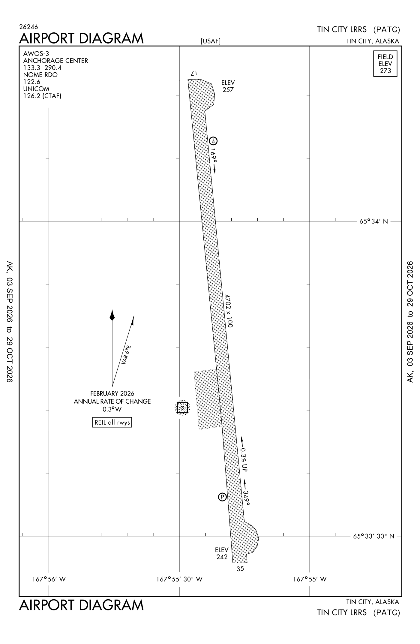
For understanding the field, not for navigation.
| Runway | Length × width | Surface | Lights |
|---|---|---|---|
| 17/35 | 4,702 × 100 ft | Gravel |
- Runway 17: PAPI, two lights on the left
- Runway 35: PAPI, two lights on the left
Radio frequencies
| Common traffic advisory (CTAF) | 126.2 | |
| Tin City Rco | 122.6 | Tin City · Communications provided by Nome Flight Service on frequency 122.60 (Tin City rco). |
| Nome and center (remote transmitter) Low | 133.3 |
Aircraft registered in Tin City from the FAA register
No aircraft on the register list Tin City, AK as the owner's town.
Accidents and incidents at or near this airport NTSB records · 1 since 1982, 0 fatal
Cases the NTSB recorded with this as the nearest airport, newest first. Each opens the full report in plain English.
Nearby within 30 nautical miles
The FAA's remarks as written in the airport file
- Closed to public; offl bus only.
- Ctn: turb on approach; radome wind not always available; surface wind from 260-310 degrees +15 KT may produce svr turb.
- PAPI unusable beyond 5 degreess right of centerline.
- Aft initial rdo contact on 126.2 or 121.5 expc 30 minimum dla for runway condition.
- Located on high bluff; runway cntr hyr than ends; line of sight NA.
- Daylight operations only.
- Alert: incrd threat of large flocks of sandhill cranes in the vicinity of airport durg mid may; incrd risk in addn to bird act; diligence recommended thrut season.
- Prior permission required all operations; mnm 1 hour prior to departure and no earlier than day travel - D317-552-9403/9283/C907-552-9403/9283.
- Passenger must coord bfr non emergency travel to site - D317-552-4400/9630/C907-552-4400/9630.
Facts from the FAA's airport file effective October 1, 2026, written out in plain English; weather from the National Weather Service's aviation weather service; registered aircraft from the FAA register as of October 5, 2026; accidents from the NTSB's public database. Owners are shown only when they are an organisation; no person is named. Check the official sources before a flight: this page is for understanding an airport, not for planning one.