
Mcchord Field (Joint Base Lewis-Mcchord)
TCM · KTCM · Tacoma, Washington · Pierce County · map
Mcchord Field (Joint Base Lewis-Mcchord) is a private airport owned by Usaf, 3 miles south of Tacoma, Washington, 322 feet above sea level. It has 2 runways; the longest, 16/34, is 10,108 feet of asphalt and concrete. It has a control tower.
Private use: permission from the owner is required before landing here.
The airport
- Codes
- FAA TCM · ICAO KTCM
- Kind
- Airport · private use, permission required · owned by the Air Force
- Owner
- Usaf
- Elevation
- 322 feet above sea level
- Control tower
- A control tower · around the clock
- Attended
- around the clock
- Lights
- runway lights sunset to sunrise; beacon sunset to sunrise
- Fuel and services
- no fuel reported; the services card below
- Notes
- customs available
- On the chart
- Seattle sectional
- Magnetic variation
- 15E
- In the FAA's files since
- August 1938
Runways 2
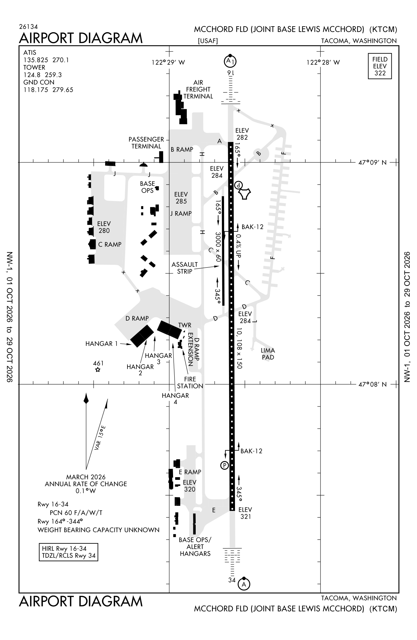
For understanding the field, not for navigation.
| Runway | Length × width | Surface | Lights |
|---|---|---|---|
| 16/34 | 10,108 × 150 ft | Asphalt and concrete | High-intensity lights |
| 162/342 | 3,000 × 60 ft | Asphalt |
- Runway 16: localizer and glideslope, PAPI, four lights on the left, approach lights with sequenced flashers (ALSF-1)
- Runway 34: ILS, PAPI, four lights on the left, approach lights with sequenced flashers (ALSF-2), right-hand traffic pattern
Radio frequencies
| Digital ATIS | 135.825 | Mcchord |
| Ground | 118.175 | Mcchord |
| Tower | 124.8 | Mcchord |
| Approach and departure | 126.5 | Mcchord |
| Emergency | 121.5 | Mcchord |
| Glasr and star | 123.9 | Mcchord |
| Jawbn and star | 125.6 | Mcchord |
| Comd and post | 134.1 | Mcchord · Uhf prim. |
Automated weather (ASOS), by phone 253-982-3434.
Aircraft registered in Tacoma from the FAA register
137 aircraft are registered to owners in Tacoma, Washington: 104 piston singles, 16 turboprops, 8 piston twins, 6 business jets, 1 weight-shift or powered parachute. Not every one of them is based at this airport; the based-aircraft count above is the FAA's figure for this airport alone.
Companies and organisations in town with two or more aircraft:
Individuals are counted, not named (the site's policy at this time). All aircraft registered in Washington.
Fuel and services as reported to the FAA
- Fuel
- none reported
- Repairs
- airframe and engine: major repairs
- Oxygen
- bulk oxygen (high- and low-pressure)
- Notes
- customs available
Nearest fields reporting jet fuel: Tacoma Narrows Airport (9 nm northwest), Auburn Municipal (15 nm northeast), Olympia Regional (20 nm southwest), Seattle-Tacoma International (20 nm north).
Nearest fields reporting avgas: Pierce County/Thun Field (8 nm east), Tacoma Narrows Airport (9 nm northwest), Auburn Municipal (15 nm northeast), Crest Airfield (19 nm northeast).
The FAA's file records what is sold and done at the field, as the airport manager reports it, not who sells it or the price; fuel sellers (FBOs) are not named in any public file. Airports selling jet fuel in Washington · avgas.
Who works here from the FAA's certificate lists and the register
Repair stations in Tacoma:
- Majestic Aerotech INC Majestic Aerotech is an FAA and EASA-certified repair station in Tacoma, Washington that manufactures, rebuilds, and recertifies emergency medical kits, first aid kits, and aircraft parts for commercial and corporate aviation.
Companies in the same town as this airport; not every one of them works from this field. All operators · all repair stations · all flight schools · all FBOs.
Accidents and incidents at or near this airport NTSB records
No NTSB accident or incident records name this airport.
Nearby within 30 nautical miles
The FAA's remarks as written in the airport file, spelled out
- One hour ntc rqr for cstms.
- Hook BAK-12B(B) (2450 feet).
- Hook BAK-12B(B) (1668 feet).
- Jasu: (MD-3M) 1(MD-3) 1(MA-1A) (AM32A-60) 1(MC-11).
- Fluid: SP presair DE-ICE-EXP 3 hour delay. Lhox lox.
- Oil: O-128-133-148-156 soap - results rqr 24 hour, 1530-0030Z++ wkd except holidays, results not available OT. tran aircraft required soap will arrival with historical eng soap data for trend analysis.
- Tran alert: operates H24. Delays can be exp. Prk ltd. All tran aircraft rqr tran alert follow me assistance.
- AMP-1/AMP-3 overt/covert assault zone lights instl in middle 5000 feet runway 16/34.see AP/1.
- Restricted: amc aircraft operates restricted dur bird watch condition moderate (takeoff and landing permissions only when departure/arrival rte avoid ident bird act, no local IFR/VFR traffic pattern act) and severe (takeoff and landing prohwo OG/CC apvl), contact ptd/ATIS/comd post for current bird watch condition.
- Restricted: tran aircrews conducting local area LO-LEVEL training msn must rcv local pro/restricted briefing FR 62 oss/osk at dsn 382-3615, C253-982-3615.
- Caution: when performing PRE-TKOF eng runup, align aircraft so that debris is not blown toward adtac alert hangar or adjacent aircraft prk ramp. Dur VFR condition, aircraft making LO approach, nml takeoff, touch and go landing, or missed approach remain at or below 1800 feet until departure end of the runway.
- Traffic pattern: before landing maintenance traffic pattern altitude commensurate with safety as long as practicable. Rectangular 1800', overhead 2300'.
Connections how this airport links to the rest of the register
- Aircraft registered in Tacoma 137 aircraft · 104 piston singles, 16 turboprops, 8 piston twins
- Wartime History Museum INC 27 aircraft in town
- Tumbleweed Leasing LLC 9 aircraft in town
- Clover Park Technical College 6 aircraft in town
- Airspeed Aviation LLC 2 aircraft in town
- Majestic Aerotech INC · repair station
- Accidents and incidents in Washington 2,709 since 1982 · 360 in the last ten years
- Nearby landing places within 30 nautical miles 8 airports, heliports and seaplane bases
- Public-use airports in Washington 131 landing places
- Washington 10,417 aircraft registered
The whole map of how records connect · these connections as data: /graph/airport/TCM.json.
Facts from the FAA's airport file effective October 1, 2026, written out in plain English; weather from the National Weather Service's aviation weather service; registered aircraft from the FAA register as of October 9, 2026; accidents from the NTSB's public database. Owners are shown only when they are an organisation; no person is named. Check the official sources before a flight: this page is for understanding an airport, not for planning one.