
Pope Army Airfield
POB · KPOB · Fayetteville, North Carolina · Cumberland County · map
Pope Army Airfield is a private airport, 12 miles northwest of Fayetteville, North Carolina, 218 feet above sea level. It has 2 runways; the longest, 05/23, is 7,501 feet of concrete. It has a control tower and fuel (Jet A, Jet A with additives).
Private use: permission from the owner is required before landing here.
Weather right now KPOB · observed 12:55 am EDT (04:55 UTC), 41 minutes ago
VFR good flying weather
- Wind from the southwest (220°) at 11 knots
- Visibility 10 miles or more
- Temperature 67°F (19°C), dew point 63°F (17°C)
- Altimeter 29.87 inHg
The forecast issued Fri 9:00 pm EDT (01:00 UTC), good until Sun 3:00 am EDT (07:00 UTC)
- From Fri 9:00 pm EDT (01:00 UTC): wind from the northeast at 7 knots, scattered clouds at 13,000 feet, overcast at 18,000 feet VFR
- Changing between Sat 4:00 am EDT (08:00 UTC) and 5:00 am EDT (09:00 UTC) to: wind from the northeast at 9 knots, light rain, a few clouds at 3,000 feet, a broken layer at 6,000 feet and more above VFR
- Changing between Sat 9:00 am EDT (13:00 UTC) and 10:00 am EDT (14:00 UTC) to: wind from the northeast at 10 knots, gusting to 18, light rain, scattered clouds at 600 feet, a broken layer at 1,200 feet and more above MVFR
- At times between Sat 11:00 am EDT (15:00 UTC) and 3:00 pm EDT (19:00 UTC): wind from the east-northeast at 12 knots, gusting to 21, rain, mist, a broken layer at 600 feet, overcast at 1,200 feet IFR
- Changing between Sat 2:00 pm EDT (18:00 UTC) and 3:00 pm EDT (19:00 UTC) to: wind from the east-northeast at 13 knots, gusting to 23, light rain showers, mist, a broken layer at 600 feet, overcast at 1,000 feet IFR
- Changing between Sat 6:00 pm EDT (22:00 UTC) and 7:00 pm EDT (23:00 UTC) to: wind from the east-northeast at 10 knots, gusting to 18, light rain, mist, a broken layer at 500 feet, overcast at 900 feet IFR
- Changing between Sat 10:00 pm EDT (02:00 UTC) and 11:00 pm EDT (03:00 UTC) to: wind from the east-northeast at 8 knots, light rain, mist, am dust storm, a broken layer at 300 feet, overcast at 500 feet LIFR
The codes as issued (METAR and TAF)
METAR KPOB 120455Z AUTO 22011KT 10SM CLR 19/17 A2987 RMK AO2 SLPNO T01930171 402850192 $
TAF KPOB 100100Z 1001/1107 04007KT 9999 SCT130 OVC180 QNH3015INS BECMG 1008/1009 04009KT 9999 -RA FEW030 BKN060 OVC110 QNH3015INS BECMG 1013/1014 05010G18KT 6000 -RA SCT006 BKN012 OVC060 QNH3008INS TEMPO 1015/1019 06012G21KT 4800 RA BR BKN006 OVC012 BECMG 1018/1019 06013G23KT 6000 -SHRA BR BKN006 OVC010 QNH3006INS BECMG 1022/1023 07010G18KT 8000 -RA BR BKN005 OVC009 QNH3005INS BECMG 1102/1103 07008KT 4800 -RA BR BKN003 OVC005 QNH2999INS TX21/1020Z TN18/1011Z LAST NO AMDS AFT 1002 NEXT 1209
From the National Weather Service's aviation weather service, refreshed every few minutes; times are local to the airport with UTC in brackets. For a flight, get your briefing from Flight Service or an approved provider.
The airport
- Codes
- FAA POB · ICAO KPOB
- Kind
- Airport · private use, permission required · owned by the Army
- Elevation
- 218 feet above sea level
- Control tower
- A control tower · around the clock
- Attended
- around the clock
- Lights
- beacon sunset to sunrise
- Fuel and services
- Jet A, Jet A with additives; the services card below
- On the chart
- Charlotte sectional
- Magnetic variation
- 7W
Runways 2
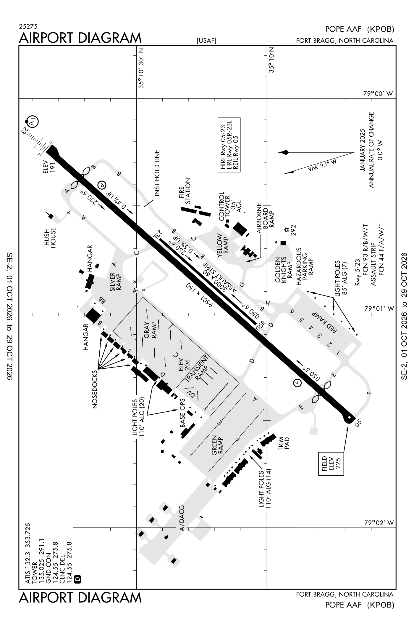
For understanding the field, not for navigation.
| Runway | Length × width | Surface | Lights |
|---|---|---|---|
| 05/23 | 7,501 × 150 ft | Concrete, good | High-intensity lights |
| 051/231 | 3,000 × 60 ft | Asphalt | Low-intensity lights |
- Runway 05: PAPI, four lights on the left
- Runway 23: ILS, PAPI, four lights on the left, approach lights with sequenced flashers (ALSF-1), right-hand traffic pattern
- Runway 051: right-hand traffic pattern
Radio frequencies
| Digital ATIS | 132.3 | Pope |
| Ground | 124.55 | Pope |
| Tower | 135.025 | Pope |
| Approach and departure · Class C airspace arriving from headings 271 to 090 | 125.175 | Pope |
| Approach and departure · Class C airspace arriving from headings 091 to 270 | 133.0 | Pope |
| Emergency | 121.5 | Pope |
| Comd and post | 134.1 | Pope |
| Pre-taxi clearance | 139.3 | Pope |
Aircraft registered in Fayetteville from the FAA register
85 aircraft are registered to owners in Fayetteville, North Carolina: 72 piston singles, 7 piston twins, 2 turboprops, 2 business jets, 1 weight-shift or powered parachute. Not every one of them is based at this airport; the based-aircraft count above is the FAA's figure for this airport alone.
Companies and organisations in town with two or more aircraft:
Individuals are counted, not named (the site's policy at this time). All aircraft registered in North Carolina.
Fuel and services as reported to the FAA
- Fuel
- Jet A, Jet A with additives
- Repairs
- airframe and engine: minor repairs
- Parking
- hangars
- Oxygen
- bulk oxygen (low-pressure)
- Also here
- cargo handling
Nearest fields reporting avgas: Fayetteville Rgnl/Grannis Field (13 nm southeast), P K Airpark (13 nm southwest), Grays Creek Airport (19 nm southeast), Moore County (19 nm west).
Other fields with jet fuel nearby: Fayetteville Rgnl/Grannis Field (13 nm southeast), P K Airpark (13 nm southwest), Moore County (19 nm west).
The FAA's file records what is sold and done at the field, as the airport manager reports it, not who sells it or the price; fuel sellers (FBOs) are not named in any public file. Airports selling jet fuel in North Carolina · avgas.
Who works here from the FAA's certificate lists and the register
Fuel and service companies in Fayetteville, by their names on the register (a start, not a directory):
- All American Aviation Services INC
- Cape Fear Aviation Services LLC Cape Fear Aviation Flight Training is a flight school based at Gray's Creek Airport in Fayetteville, North Carolina.
- M&K Aviation Services LLC
Repair stations in Fayetteville:
- Centurion Aviation Services Centurion Aviation Services is a repair station located in Fayetteville, North Carolina, holding an FAA Part 145 certificate.
- Frederick M. Powell Powell Avionics is a repair station based at Fayetteville Regional Airport in North Carolina that provides avionics installation, custom aircraft panel design and fabrication, aircraft maintenance and repair, and FAA certification services
- Sierra Nevada Company, LLC.
Companies in the same town as this airport; not every one of them works from this field. All operators · all repair stations · all flight schools · all FBOs.
Accidents and incidents at or near this airport NTSB records
No NTSB accident or incident records name this airport.
Nearby within 30 nautical miles
The FAA's remarks as written in the airport file, spelled out
- Bearing strength runway 05-23: ST175; TDT760; TRT585.
- Pattern altitude: overhead traffic pattern 1782 feet AGL/ 2000 feet above sea level, runway 23 enter 3 NM initial; no ovhd runway 05.
- See flip AP/1 supplementary airport rmk.
- Base operations.
- Runway 051/231 used as an assault strip.
- Light: high-intensity runway lights located 16 feet FR runway 05/23 edge.
- Jasu: (A/M32A-86) 1(MA-1A).
- Fluid: SP lpox lox.
- Oil: O-128-IN can only; -133-148.
- Restricted: effective runway 05-23 (between displ thld) available for takeoff and landing is 7501 feet. Do not land prior to runway thld. Displ thld may be used for takeoff and landing rollout. Offl terps end of runway for obstruction protection is mrk thld. Do not use opposite end displ thld for takeoff computations or takeoff roll.
- Restricted: cat east approach minimum unavailable due R5311 located 2.5 NM departure end runway 23.
- Caution: afld light intmt between sunset/sunrise due to local night vision tng, NON-PARTICIPATING aircraft contact tower to incr ints.
Connections how this airport links to the rest of the register
- Aircraft registered in Fayetteville 85 aircraft · 72 piston singles, 7 piston twins, 2 turboprops
- Cape Fear Aviation Maintenance LLC 13 aircraft in town
- All American Aviation Services INC 6 aircraft in town
- Rr&D LP 2 aircraft in town
- Dk1 Aviation LLC 2 aircraft in town
- All American Aviation Services INC 7 aircraft · FBO or fuel seller
- Cape Fear Aviation Services LLC 1 aircraft · FBO or fuel seller
- M&K Aviation Services LLC 1 aircraft · FBO or fuel seller
- Centurion Aviation Services · repair station
- Frederick M. Powell · repair station
- Sierra Nevada Company, LLC. · repair station
- Accidents and incidents in North Carolina 1,759 since 1982 · 306 in the last ten years
- Nearby landing places within 30 nautical miles 8 airports, heliports and seaplane bases
- Public-use airports in North Carolina 106 landing places
- North Carolina 7,129 aircraft registered
The whole map of how records connect · these connections as data: /graph/airport/POB.json.
Facts from the FAA's airport file effective October 1, 2026, written out in plain English; weather from the National Weather Service's aviation weather service; registered aircraft from the FAA register as of October 9, 2026; accidents from the NTSB's public database. Owners are shown only when they are an organisation; no person is named. Check the official sources before a flight: this page is for understanding an airport, not for planning one.