
San Clemente Island Nalf Airport
NUC · KNUC · San Clemente Island, California · Orange County · map
San Clemente Island Nalf Airport is a private airport owned by the US Navy in San Clemente Island, California, 184 feet above sea level. It has 3 runways; the longest, 06/24, is 9,301 feet of concrete. It has a control tower.
Private use: permission from the owner is required before landing here.
Weather right now KNUC · observed 4:56 pm PDT (23:56 UTC), 6 minutes ago
VFR good flying weather
- Wind from the south-southwest (210°) at 6 knots
- Visibility 10 miles or more
- Temperature 78°F (26°C), dew point 69°F (21°C)
- Altimeter 29.81 inHg
The forecast issued Tue 4:02 pm PDT (23:02 UTC), good until Wed 4:00 pm PDT (23:00 UTC)
- From Tue 4:00 pm PDT (23:00 UTC): wind from the west at 9 knots, clear skies
- Changing between Tue 11:00 pm PDT (06:00 UTC) and 1:00 am PDT (08:00 UTC) to: wind light and variable, clear skies
- Changing between Wed 9:00 am PDT (16:00 UTC) and 11:00 am PDT (18:00 UTC) to: wind from the west at 9 knots, am dust storm, clear skies
The codes as issued (METAR and TAF)
METAR KNUC 062356Z 21006KT 10SM CLR 26/21 A2981 RMK AO2 SLP091 T02560206 10283 20256 56014 $
TAF KNUC 062302Z 0623/0723 28009KT 9999 SKC QNH2977INS BECMG 0706/0708 VRB06KT 9999 SKC QNH2981INS BECMG 0716/0718 27009KT 9999 SKC QNH2979INS LAST NO AMDS AFT 0701 NEXT 0715 TX28/0722Z TN21/0712Z FS30243
From the National Weather Service's aviation weather service, refreshed every few minutes; times are local to the airport with UTC in brackets. For a flight, get your briefing from Flight Service or an approved provider.
The airport
- Codes
- FAA NUC · ICAO KNUC
- Kind
- Airport · private use, permission required · owned by the Navy
- Owner
- US Navy
- Elevation
- 184 feet above sea level
- Control tower
- A control tower with radar approach control · 8:00 am to 6:00 pm mon-thu; 8:00 am to 4:00 pm friday; closed wkend and holidays, other times by notam.
- Attended
- Monday, 3:00 pm to 0200z+; Tuesday to Thursday, 4:00 pm to 0200z+; Friday, 4:00 pm to 0000z+; every day, closed saturday, sunday and holidays.
- Lights
- runway lights see the remarks below; beacon sunset to sunrise
- On the chart
- Los Angeles sectional
- Magnetic variation
- 12E
Runways 3
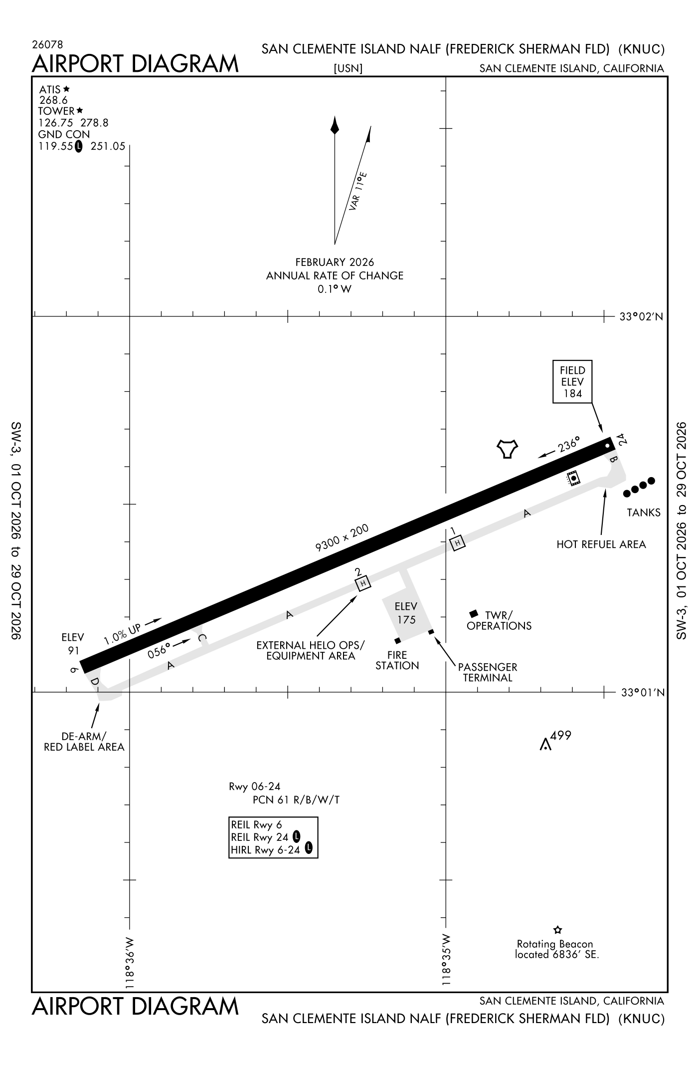
For understanding the field, not for navigation.
| Runway | Length × width | Surface | Lights |
|---|---|---|---|
| 06/24 | 9,301 × 200 ft | Concrete | High-intensity lights |
| H1 | 70 × 70 ft | Concrete | |
| H2 | 70 × 70 ft | Concrete |
Radio frequencies
| Ground | 119.55 | San Clemente Island |
| Tower | 126.75 | San Clemente Island |
| Approach and departure | 127.05 | San Clemente Island |
| Emergency | 121.5 | San Clemente Island |
Aircraft registered in San Clemente Island from the FAA register
No aircraft on the register list San Clemente Island, CA as the owner's town.
Accidents and incidents at or near this airport NTSB records · 1 since 1982, 0 fatal
Cases the NTSB recorded with this as the nearest airport, newest first. Each opens the full report in plain English.
Nearby within 30 nautical miles
The FAA's remarks as written in the airport file
- (frederick sherman field)
- Available only drg hours of open. After hours for emergency activate high-intensity runway lights runway 06/24 5 step and runway end identifier lights runway 24 1 step - 119.55.
- Other times by NOTAM.
- Ols
- Jasu - 1(GTC-85) 1(A-4).
- Fuel - J5.
- Fluid - SP.
- Caution: extv misl and OFF-SHORE bombardment in vicinity San Clemente Island. Perimeter road in close proximity to airfield, use extreme caution. Hold short markings less than 175 feet. Expect hold short instructions from tower.
- Traffic pattern reduced runway separation standard in effective usn/usmc aircraft (only allowed during ccas).
- Restricted - prior permission required for civil aircraft at all times and military OT, C619-524-9240. Required to use nuc as bingo field for carrier operates rqr 7 days PN and special air operates after nml operates hours rqr 72 hour PN through San Clemente Island air operations C619-524-9240.
- Parking ramp designed for five metroliner sized aircraft (on the line adjacent to the terminal) and eight H-60 sized aircraft (on the northern two lines - 4 each line). When cargo aircraft occupy the center parking line (vic of spot 5) nonstd taxilane clnc may exist, use ctn taxing around cargo aircraft.
- Simulated aircraft carrier deck lights out of service.
Facts from the FAA's airport file effective October 1, 2026, written out in plain English; weather from the National Weather Service's aviation weather service; registered aircraft from the FAA register as of October 5, 2026; accidents from the NTSB's public database. Owners are shown only when they are an organisation; no person is named. Check the official sources before a flight: this page is for understanding an airport, not for planning one.