
Camp Pendleton Marine Corps Air Station (Munn Field)
NFG · KNFG · Oceanside, California · San Diego County · map
Camp Pendleton Marine Corps Air Station (Munn Field) is a private airport owned by the US Navy, 6 miles north of Oceanside, California, 78 feet above sea level. Its one runway, 03/21, is 6,005 feet of asphalt. It has a control tower.
Private use: permission from the owner is required before landing here.
Weather right now KNFG · observed 2:52 pm PDT (21:52 UTC), 60 minutes ago
VFR good flying weather
- Wind from the west (270°) at 9 knots, gusting to 19
- Visibility 10 miles or more
- Sky: a few clouds at 5,000 feet
- Temperature 102°F (39°C), dew point 54°F (12°C)
- Altimeter 29.76 inHg
The forecast issued Tue 9:00 am PDT (16:00 UTC), good until Wed 3:00 pm PDT (22:00 UTC)
- From Tue 9:00 am PDT (16:00 UTC): wind light and variable, a broken layer at 15,000 feet VFR
- Changing between Tue 11:00 am PDT (18:00 UTC) and 1:00 pm PDT (20:00 UTC) to: wind from the southwest at 10 knots, gusting to 20, scattered clouds at 15,000 feet
- From Tue 7:00 pm PDT (02:00 UTC): wind from the southwest at 5 knots, scattered clouds at 15,000 feet
- From Wed 2:00 am PDT (09:00 UTC): wind light and variable, scattered clouds at 15,000 feet
- Changing between Wed 8:00 am PDT (15:00 UTC) and 10:00 am PDT (17:00 UTC) to: wind from the northeast at 3 knots, scattered clouds at 15,000 feet
The codes as issued (METAR and TAF)
METAR KNFG 062152Z 27009G19KT 10SM FEW050 39/12 A2976 RMK AO2 SLP076 T03890122
TAF KNFG 061600Z 0616/0722 VRB03KT 9999 BKN150 QNH2983INS BECMG 0618/0620 22010G20KT 9999 SCT150 QNH2973INS FM070200 23005KT 9999 SCT150 QNH2975INS FM070900 VRB03KT 9999 SCT150 QNH2980INS BECMG 0715/0717 04003KT 9999 SCT150 QNH2976INS TX39/0623Z TN19/0713Z
From the National Weather Service's aviation weather service, refreshed every few minutes; times are local to the airport with UTC in brackets. For a flight, get your briefing from Flight Service or an approved provider.
The airport
- Codes
- FAA NFG · ICAO KNFG
- Kind
- Airport · private use, permission required · owned by the Navy
- Owner
- US Navy
- Elevation
- 78 feet above sea level
- Control tower
- A control tower · 4:00 pm to 8:00 am mon-thu, 1600-0100z++ friday; closed saturday, sunday and holidays.
- Attended
- Monday to THUR, 4:00 pm to 0800z; Friday, 4:00 pm to 0100z++
- Lights
- runway lights see the remarks below; beacon sunset to sunrise
- On the chart
- Los Angeles sectional
- Magnetic variation
- 13E
- In the FAA's files since
- December 1945
Runway
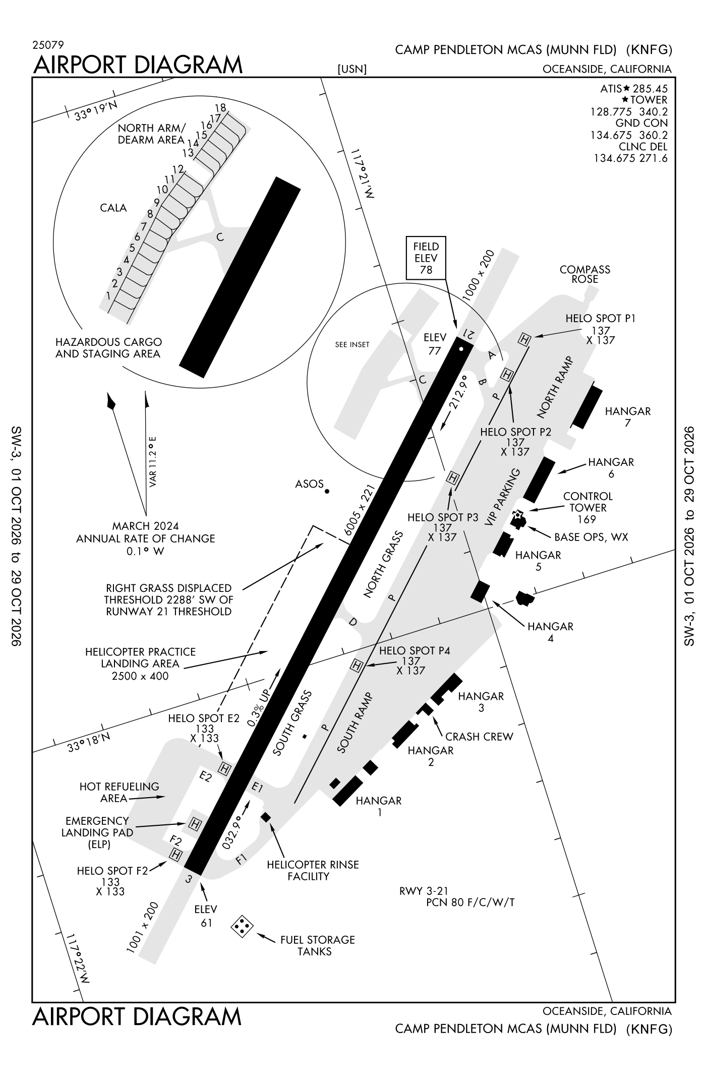
For understanding the field, not for navigation.
| Runway | Length × width | Surface | Lights |
|---|---|---|---|
| 03/21 | 6,005 × 221 ft | Asphalt | High-intensity lights |
- Runway 03: PAPI, four lights on the right
- Runway 21: PAPI, four lights on the left, SALSF, right-hand traffic pattern
Radio frequencies
| Clearance delivery · Ground | 134.675 | Camp Pendleton |
| Tower | 128.775 | Camp Pendleton |
| Approach and departure · Class B airspace 294-332 San below 7,000 feet | 127.3 | Camp Pendleton |
| Emergency | 121.5 | Camp Pendleton |
| Range and ctl Long rifle | 123.2 | Camp Pendleton |
| Legoz and star | 127.4 | Camp Pendleton |
Aircraft registered in Oceanside from the FAA register
71 aircraft are registered to owners in Oceanside, California: 56 piston singles, 4 helicopters, 4 balloons, 3 gliders, 2 piston twins. Not every one of them is based at this airport; the based-aircraft count above is the FAA's figure for this airport alone.
Companies and organisations in town with two or more aircraft:
Individuals are counted, never named. All aircraft registered in California.
Accidents and incidents at or near this airport NTSB records · 1 since 1982, 0 fatal
Cases the NTSB recorded with this as the nearest airport, newest first. Each opens the full report in plain English.
Nearby within 30 nautical miles
The FAA's remarks as written in the airport file
- Pcl on tower 128.775 and 340.2. When tower closed, activate salsf runway 21; PAPI runway 03 and 21; high-intensity runway lights runway 03/21 - 128.775.
- Traffic pattern: right traffic runway 21. F/west 1100 feet, R/west 600 feet, rising terrain all quad to 3200 feet. All aircraft use landing light in traffic pattern after sunset and in imc.
- Fuel: J5.
- NS abtmt - avoid ovft mcb ranch house located 2000' northeast approach end runway 21.
- Restricted: prior permission required 24 hour PN exe for hot reful or pattern work, agricultural and cstms service are available upon required with 48 hours ntc. Mcas flight clnc dsn 365-8016/8026, C760-725-8016/8026, 1600-0100Z++MON-FRI. ltd ramp space, aircraft prior permission required strictly enforced for all passenger, parts, cargo and tran aircraft.
- Misc: weather fcst available 2 hour PN.
- Caution: numerous haz to flight/gnd operates. Extv VFR traffic in class D airspace. HI density traffic in class D airspace 1900-2300Z++. tenant aircraft have priority for local pattern operates. See flip AP/1 supplementary airport information.
- Helipads P1, P2, P3, P4 dimensions 137 feet by 137 feet. E2 and F2 dimensions 133 feet by 133 feet.
- LCL-BASED and NON-TENANT aircraft are authorized to conduct one closed field full stop arrival and/or one closed field departure.
- Caution: helo spot P2 closed. Due to apn loading, rdcd wingtip sepn available on taxiway P for aircraft C-130 and lrgr.
Facts from the FAA's airport file effective October 1, 2026, written out in plain English; weather from the National Weather Service's aviation weather service; registered aircraft from the FAA register as of October 5, 2026; accidents from the NTSB's public database. Owners are shown only when they are an organisation; no person is named. Check the official sources before a flight: this page is for understanding an airport, not for planning one.