
Cape Lisburne Lrrs Airport
LUR · PALU · Cape Lisburne, Alaska · Barrow County · map
Cape Lisburne Lrrs Airport is a private airport owned by the U.S. Air Force in Cape Lisburne, Alaska, 14 feet above sea level. Its one runway, 09/27, is 4,800 feet of gravel.
Private use: permission from the owner is required before landing here.
Weather right now PALU · observed 3:55 pm AKDT (23:55 UTC), 54 minutes ago
VFR good flying weather
- Wind calm
- Visibility 7 miles
- Sky: scattered clouds at 2,500 feet, a broken layer at 5,000 feet, a broken layer at 6,000 feet, a broken layer at 8,000 feet
- Temperature 44°F (7°C), dew point 42°F (6°C)
- Altimeter 29.41 inHg
No terminal forecast is issued for this station. The nearest forecast is usually at the closest larger airport.
The codes as issued (METAR and TAF)
METAR PALU 112355Z AUTO 00000KT 7SM SCT025 BKN050 BKN060 BKN080 07/06 A2941 RMK AO2 SLP959 T00680055 10070 20051 51007;
From the National Weather Service's aviation weather service, refreshed every few minutes; times are local to the airport with UTC in brackets. For a flight, get your briefing from Flight Service or an approved provider.
The airport
- Codes
- FAA LUR · ICAO PALU
- Kind
- Airport · private use, permission required · owned by the Air Force
- Owner
- U.S. Air Force
- Elevation
- 14 feet above sea level
- Control tower
- No control tower
- Attended
- Monday to Friday, 8:00 am to 5:00 pm
- Lights
- runway lights see the remarks below
- Fuel and services
- no fuel reported; the services card below
- On the chart
- Cape Lisburne sectional
- Magnetic variation
- 7E
- In the FAA's files since
- July 1951
Runway
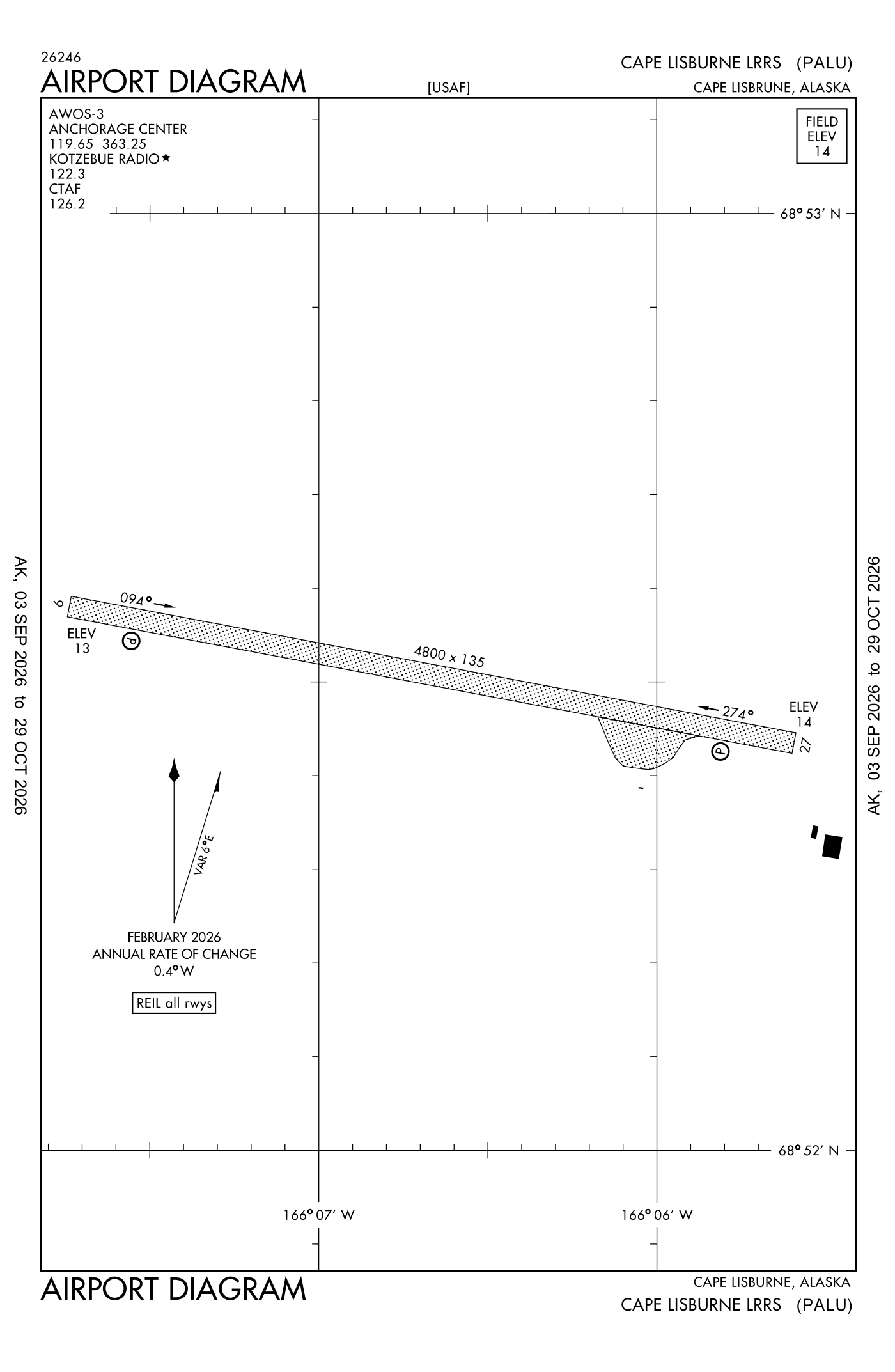
For understanding the field, not for navigation.
| Runway | Length × width | Surface | Lights |
|---|---|---|---|
| 09/27 | 4,800 × 135 ft | Gravel, poor |
- Runway 09: PAPI, two lights on the right
- Runway 27: PAPI, two lights on the left, right-hand traffic pattern
Radio frequencies
| Common traffic advisory (CTAF) | 126.2 | |
| Cape Lisburne Center (remote transmitter) Low/high | 119.65 | |
| Cape Lisburne Rco | 122.3 | Cape Lisburne · Communications provided by kotzebue Flight Service on frequency 122.3 (Cape Lisburne rco). |
Automated weather (AWOS-3), by phone 907-552-9730.
Aircraft registered in Cape Lisburne from the FAA register
No aircraft on the register list Cape Lisburne, AK as the owner's town.
Fuel and services as reported to the FAA
- Fuel
- none reported
- Also here
- cargo handling
The FAA's file records what is sold and done at the field, as the airport manager reports it, not who sells it or the price; fuel sellers (FBOs) are not named in any public file. Airports selling jet fuel in Alaska · avgas.
Accidents and incidents at or near this airport NTSB records
No NTSB accident or incident records name this airport.
The FAA's remarks as written in the airport file, spelled out
- Runway end identifier lights runway 09 and 27; PAPI runway 09 and 27 operates continuously.
- Closed holidays.
- Ext 208.
- Ctn: runway at base of MT; MT slps in approach zone both ends. Centerline marked with dye in winter.
- Ctn: surface wind ovr 10 KT may produce svr turb. Bird nests in cliff in the vicinity of airport.
- All operations 24 hour prior permission required; mnm 1 hour prior to departure for site - D317-552-9730/9637/C907-552-9730/9637.
- Passenger must coord bfr non emergency travel to site - D317-552-4935/1089/C907-552-4935/1089.
- Closed to pub; offl bus only. Closed wkend and fed holidays.
Connections how this airport links to the rest of the register
- Accidents and incidents in Alaska 5,930 since 1982 · 829 in the last ten years
- Public-use airports in Alaska 392 landing places
- Alaska 9,146 aircraft registered
The whole map of how records connect · these connections as data: /graph/airport/LUR.json.
Facts from the FAA's airport file effective October 1, 2026, written out in plain English; weather from the National Weather Service's aviation weather service; registered aircraft from the FAA register as of October 9, 2026; accidents from the NTSB's public database. Owners are shown only when they are an organisation; no person is named. Check the official sources before a flight: this page is for understanding an airport, not for planning one.