
Laguna Army Airfield (Yuma Proving Ground)
LGF · KLGF · Yuma Proving Ground (Yuma), Arizona · Yuma County · map
Laguna Army Airfield (Yuma Proving Ground) is a private airport owned by the US Army Aeronautical Svcs Agency, 12 miles northeast of Yuma Proving Ground (Yuma), Arizona, 433 feet above sea level. It has 5 runways; the longest, 18/36, is 6,142 feet of asphalt. It has a control tower and fuel (100LL avgas).
Private use: permission from the owner is required before landing here.
Weather right now KLGF · observed 3:55 pm MST (22:55 UTC), 35 minutes ago
VFR good flying weather
- Wind from the west (270°) at 5 knots
- Visibility 9 miles
- Temperature 104°F (40°C), dew point 52°F (11°C)
- Altimeter 29.77 inHg
No terminal forecast is issued for this station. The nearest forecast is usually at the closest larger airport.
The codes as issued (METAR and TAF)
METAR KLGF 062255Z AUTO 27005KT 9SM CLR 40/11 A2977 RMK AO2 SLP077 T03990110 $
From the National Weather Service's aviation weather service, refreshed every few minutes; times are local to the airport with UTC in brackets. For a flight, get your briefing from Flight Service or an approved provider.
The airport
- Codes
- FAA LGF · ICAO KLGF
- Kind
- Airport · private use, permission required · owned by the Army
- Owner
- US Army Aeronautical Svcs Agency
- Elevation
- 433 feet above sea level
- Control tower
- A control tower · 6:00 am to 4:00 pm mon-fri, closed holidays, o/t by notam.
- Attended
- Monday to Friday, 6:00 am to 4:00 pm; every day, closed holidays
- Lights
- runway lights see the remarks below; beacon sunset to sunrise
- Fuel
- 100LL avgas
- On the chart
- Phoenix sectional
- Magnetic variation
- 13E
Runways 5
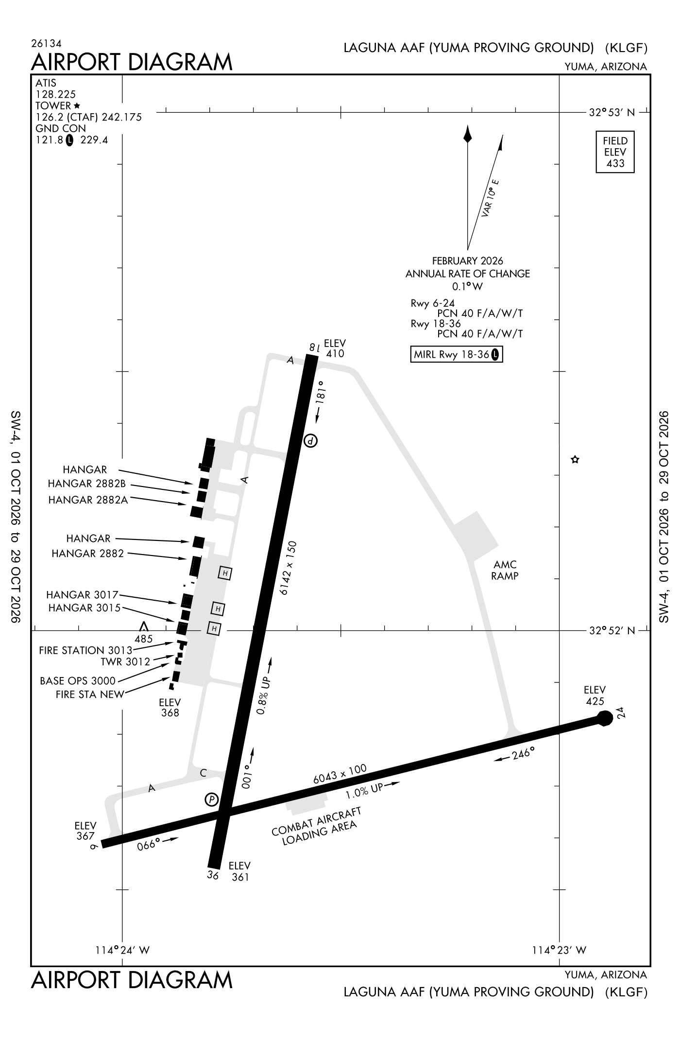
For understanding the field, not for navigation.
| Runway | Length × width | Surface | Lights |
|---|---|---|---|
| 18/36 | 6,142 × 151 ft | Asphalt | Medium-intensity lights |
| 06/24 | 6,043 × 100 ft | Asphalt | |
| H1 | 40 × 40 ft | Asphalt | |
| H2 | 40 × 40 ft | Asphalt | |
| H3 | 40 × 40 ft | Asphalt |
- Runway 18: PAPI, four lights on the left
- Runway 36: PAPI, four lights on the left, right-hand traffic pattern
- Runway 06: right-hand traffic pattern
Radio frequencies
| Common traffic advisory (CTAF) · Tower | 126.2 | Laguna · The common traffic frequency 242.175 |
| ATIS (recorded airport information) | 128.225 | Laguna |
| Ground | 121.8 | Laguna |
| Yuma and center (remote transmitter) High | 118.0 | Laguna |
| Range and ctl | 119.0 | Laguna |
| Yuma and center (remote transmitter) Low/high | 124.7 | Laguna |
| Yuma A Center (remote transmitter) Low/high | 125.55 | Laguna |
Aircraft registered in Yuma Proving Ground (Yuma) from the FAA register
No aircraft on the register list Yuma Proving Ground (Yuma), AZ as the owner's town.
Accidents and incidents at or near this airport NTSB records · 1 since 1982, 0 fatal
Cases the NTSB recorded with this as the nearest airport, newest first. Each opens the full report in plain English.
Nearby within 30 nautical miles
The FAA's remarks as written in the airport file
- The common traffic frequency 242.175
- Ctn: wildlife and coyotes on and in the vicinity of airport; spcly at night.
- Activate medium-intensity runway lights runway 18/36 - 126.2. PAPI runway 18 and 36 operates continuously durg operations; otr time on required - base operations.
- Traffic pattern: right traffic runway 06 and 36. F/west 1700 feet above sea level. R/west 1100 feet above sea level. No right traffic runway 18.
- Ctn: C-130 and lrgr turn around on runway NA except prior apvl for emergency or congestion.
- JASU-5(gpu) 3(59B2-1B).
- Fuel: 100LL, F24 available 1340-2400Z MON-FRI; closed holidays. Pol available with 24 hour prior permission required for transient. Contr fuel - avcard only.
- Tran alert: ltd maintenance service available.
- Ctn: operations on cibola range 1 NM. paja in the vicinity of 5 NM.
- Operations 6:00 am to 4:00 pm MON-FRI; closed holidays; otr time by NOTAM.
- Restricted: offl bus only. Restricted area 4 NM east. Ovft of housing area 3 NM southwest NA. transient 24 hour prior permission required - D899-2014/2241, C928-328-2014/2241.
- Service: fuel, lox service available - base operations.
Facts from the FAA's airport file effective October 1, 2026, written out in plain English; weather from the National Weather Service's aviation weather service; registered aircraft from the FAA register as of October 5, 2026; accidents from the NTSB's public database. Owners are shown only when they are an organisation; no person is named. Check the official sources before a flight: this page is for understanding an airport, not for planning one.