
Brackett Field
POC · KPOC · La Verne, California · Los Angeles County · map
Brackett Field is a public-use airport owned by the County of Los Angeles, 1 mile southwest of La Verne, California, 1,014 feet above sea level. It has 2 runways; the longest, 08R/26L, is 4,840 feet of asphalt. It has a control tower, fuel (100LL avgas, Jet A) and about 94 general-aviation aircraft based on the field by the FAA's count. The FAA counts about 122,745 takeoffs and landings a year.
Quick answers answers refresh every morning
What is the airport code for Brackett Field?
Its FAA code is POC, and its ICAO code is KPOC.
Where is Brackett Field?
It is 1 mile southwest of La Verne, California, 1,014 feet above sea level.
How long is the longest runway at Brackett Field?
The longest of its 2 runways, 08R/26L, is 4,840 feet long.
Does Brackett Field have a control tower?
Yes, it has a control tower.
What fuel can you buy at Brackett Field?
The FAA's airport file lists 100LL avgas, Jet A.
Are there flight schools at Brackett Field?
8 flight schools, flying clubs or college flight programmes are based within about 15 miles of it, including Right Rudder Flight Training LLC and Skylogix Aircraft LLC. Compare them
Where are the nearest FAA examiners to Brackett Field?
40 pilot examiners and 49 aviation medical examiners work within 50 nautical miles. See them by name
Weather and planning now, the forecast, warnings, pilot reports, winds aloft, restrictions
Fetching the weather now, the forecast, the warnings in force, pilot reports and the winds aloft for Brackett Field…
Wind map live wind over the area, from Windy.com
Colours show wind speed, the moving lines its direction; drag the time bar for the coming days. Map and forecast by Windy.com.
The airport facts, runways, radio, fuel and services, the FAA's remarks
The airport
- Codes
- FAA POC · ICAO KPOC
- Kind
- Airport · open to the public · publicly owned
- Owner
- County of Los Angeles
- Elevation
- 1,014 feet above sea level
- Control tower
- A control tower · 7:00 am to 9:00 pm
- Attended
- around the clock
- Lights
- runway lights see the remarks below; beacon sunset to sunrise
- Fuel and services
- 100LL avgas, Jet A; the services card below
- On the chart
- Los Angeles sectional
- Magnetic variation
- 14E
- In the FAA's files since
- January 1942
Runways 2
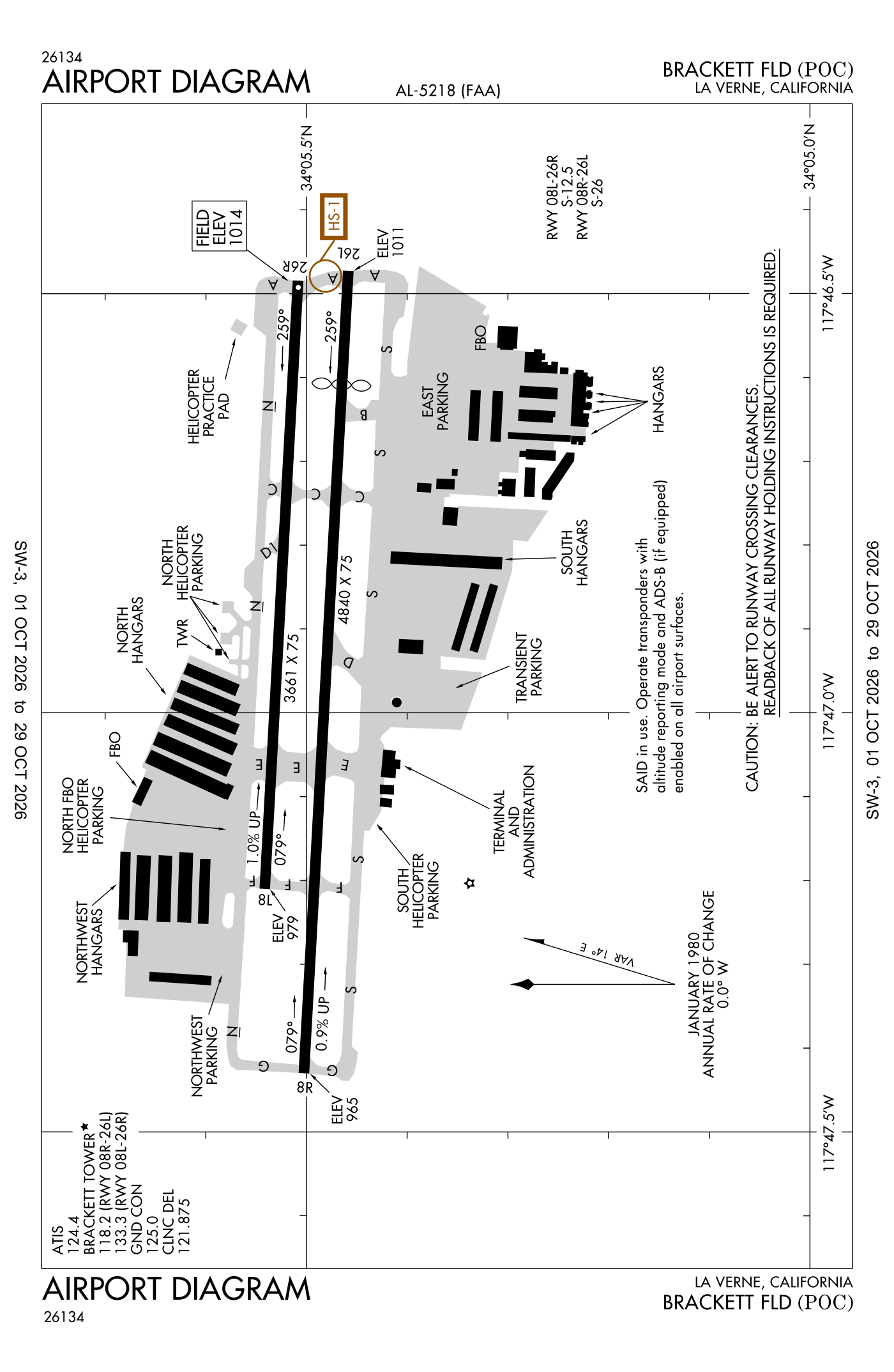
For understanding the field, not for navigation.
| Runway | Length × width | Surface | Lights |
|---|---|---|---|
| 08R/26L | 4,840 × 75 ft | Asphalt, good | Medium-intensity lights |
| 08L/26R | 3,661 × 75 ft | Asphalt, good |
- Runway 08R: PAPI, four lights on the left, right-hand traffic pattern, hill 254 ft high 3,651 ft from the end
- Runway 26L: ILS, PAPI, four lights on the left, threshold displaced 689 ft, road 15 ft high 200 ft from the end
- Runway 08L: hill 240 ft high 4,750 ft from the end
- Runway 26R: right-hand traffic pattern, road 15 ft high 540 ft from the end
Radio frequencies
| Common traffic advisory (CTAF) · Tower Runway 08R/26L | 118.2 | Brackett |
| UNICOM | 122.95 | |
| ATIS (recorded airport information) | 124.4 | Brackett |
| Clearance delivery | 121.875 | Brackett |
| Ground | 125.0 | Brackett |
| Tower Runway 08L/26R | 133.3 | Brackett |
| Approach and departure SW-NORTH | 125.5 | Brackett |
| Class C airspace · Seter and star · Ziggy and star NORTH-NE | 127.0 | Brackett |
Automated weather (AWOS-3PT), by phone 909-962-5407.
Fuel and services as reported to the FAA
- Fuel
- 100LL avgas, Jet A
- Repairs
- airframe and engine: major repairs
- Parking
- tie-downs
- Oxygen
- bottled oxygen (low-pressure)
- Also here
- air ambulance, avionics, charter flights, flight instruction, aircraft rental, aircraft sales, aerial surveying
Other fields with jet fuel nearby: Cable Airport (5 nm east), Ontario International (9 nm east), Chino Airport (10 nm southeast).
The FAA's file records what is sold and done at the field, as the airport manager reports it, not who sells it or the price; fuel sellers (FBOs) are not named in any public file. Airports selling jet fuel in California · avgas.
The FAA's remarks as written in the airport file, spelled out
- When the control tower closed, airport light operators continuously from 9:00 pm to 7:00 am local.
- Unusable beyond 5 degrees L of centerline.
- Approach ratio to displaced threshold 50:1. Approach ratio to displaced threshold over +65 feet poles 1988 feet from displaced threshold, 250 feet L, 30:1.
- Runway 08L/26R unlighted.
- Birds and wildlife in vicinity of airport.
- Rapidly rising terrain 1 mile W-NW of airport.
Flights and activity in the air now, the airlines, based aircraft, takeoffs and landings
Activity now checking the volunteer receiver network…
Within ten miles
- Looking…
Arrivals and departures, last hour
- Looking…
From the volunteer receiver network, a few minutes behind at most; aircraft whose owners asked the FAA not to be displayed are left out; no person is named. Open the live map here.
Based aircraft as counted for the FAA, fiscal year 2024
Based aircraft, as a table
| aircraft | |
|---|---|
| single-engine | 81 |
| multi-engine | 6 |
| jets | 1 |
| helicopters | 1 |
| other | 5 |
The FAA's count is the general-aviation aircraft kept on the field (singles, twins, business jets, helicopters) from its Terminal Area Forecast, the latest year with an actual count; airline fleets are never counted as based anywhere, so a big airline airport shows a small number. The register section below shows how many aircraft are registered to owners in town, a different measure again.
Takeoffs and landings a year about 122,745, the FAA's fiscal year 2024 (October 2023 to September 2024)
Takeoffs and landings, as a table
| a year | |
|---|---|
| airline | 5 |
| air taxi and commuter | 2,473 |
| general aviation, travelling | 41,555 |
| general aviation, local | 78,526 |
| military | 186 |
Local flights stay in the traffic pattern or nearby, often practice; travelling flights arrive from or leave for somewhere else. Counts at airports without a tower are the FAA's estimates. How this compares nationally: Airports by the numbers.
Who flies and works here aircraft registered in town, the companies, the examiners nearby
Aircraft registered in La Verne from the FAA register
53 aircraft are registered to owners in La Verne, California: 34 piston singles, 9 helicopters, 4 piston twins, 3 balloons, 2 turboprops. Not every one of them is based at this airport; the based-aircraft count above is the FAA's figure for this airport alone.
Companies and organisations in town with two or more aircraft:
Individuals are counted, not named (the site's policy at this time). All aircraft registered in California.
Who works here from the FAA's certificate lists and the register
Flight schools, flying clubs and college flight programmes based within about 15 miles:
- Right Rudder Flight Training LLC 4 aircraft · La Verne Right Rudder Aviation is a full-service FBO at Inverness Airport (KINF) in Florida offering 24-hour fuel (100LL and Jet A), hangar and tie-down storage, maintenance, and aircraft sales and leasing.
- Skylogix Aircraft LLC 3 aircraft · La Verne Skylogix Aviation is an FAA-authorized flight school based at Brackett Field Airport (KPOC) in La Verne, California.
- Rv-6A Flyers LLC 1 aircraft · San Dimas, 2 miles away
- Global Aviators Academy INC 4 aircraft · Claremont, 5 miles away Global Aviators Academy is a flight school in Claremont, California that offers pilot training from private pilot through airline transport pilot certificates, as well as instrument and flight instructor ratings.
- Mt San Antonio College 4 aircraft · Walnut, 6 miles away
- Draco Flight School 15 aircraft · Chino, 12 miles away
- Cal-Aerofab Flight Academy INC 9 aircraft · Chino, 12 miles away Cal-Aerofab Flight Academy is a non-profit flight school based in Chino, California that provides aircraft maintenance training and flight experience to participants.
- Dubois Aviation INC 8 aircraft · Chino, 12 miles away DuBois Aviation is a flight school at Chino Airport in California that provides one-on-one flight instruction for private pilot, instrument, commercial, and flight instructor certificates in both airplanes and helicopters.
Charter operators and airlines based in La Verne:
- Bluesky Helicopters, LLC 1 aircraft on the certificate BlueSky Helicopters is a utility helicopter operator based in La Verne, California, providing aerial services including heavy lift operations, power-line work, utility and construction support, aerial firefighting, film production coordinat
Repair stations in La Verne:
- Aero Performance Specialties Aero Performance Specialties is a repair station in Southern California that provides avionics installation and upgrades, aircraft maintenance and repairs, pitot/static and transponder certifications, and custom instrument panel fabrication
- Dpi Labs INC DPI Labs is a manufacturer of aircraft cabin management systems, LED lighting, in-flight entertainment systems, and cockpit displays for business, commercial, military, and government aircraft.
- Horizon Aviation LLC
- Pacific Oil Cooler Service INC Pacific Oil Cooler Service, Inc.
- Priority Aviation Maintenance INC
Companies in the same town as this airport, and schools within about 15 miles of it (each placed at the main public airport of its town, or at the town's centre); not every one of them works from this field. All operators · all repair stations · all flight schools · all FBOs.
Examiners and inspectors nearby designated by the FAA · within 50 nautical miles
40 pilot examiners (the FAA's designated pilot examiners, who give the practical tests for pilot certificates) are based within 50 nautical miles: 39 for private pilot, 34 for commercial and instrument, 13 for airline transport pilot, 24 for flight instructor, 3 for sport pilot, 5 for type ratings; 34 for airplanes, 18 for multi-engine airplanes, 6 for helicopters, 2 for gliders. Also nearby: 5 sport aviation examiners, 49 aviation medical examiners, 13 mechanic examiners, 8 airworthiness representatives (maintenance), 8 airworthiness representatives (manufacturing), 27 engineering representatives, 1 parachute rigger examiner, 37 training center evaluators, 6 training center examiners.
- James Mason Reid private pilot, commercial and instrument, airline transport pilot, flight instructor, instrument instructor, instructor renewals, military competency, ground instructor; airplanes, multi-engine airplanes · Brackett Field / KPOC- Mt Sac Aviation (Collge Aviation ) · La Verne, CA (0 nm) · (909) 973-7213 · [email protected]
- Russell Calverley private pilot, commercial and instrument, flight instructor, instructor renewals, military competency, ground instructor, foreign pilot certificates; airplanes · Mount San Antonio College of Aviation · La Verne, CA (0 nm) · (909) 489-8589 · [email protected]
- Anthony James Gadis private pilot, commercial and instrument, flight instructor; airplanes, multi-engine airplanes · Upland, CA (5 nm) · (909) 215-0461 · [email protected]
- Christopher Robert Kaplan private pilot; airplanes · Vmc Aviation · Upland, CA (5 nm) · (916) 990-7626 · [email protected]
- Kenneth Warren Earl private pilot, commercial and instrument, airline transport pilot, flight instructor, instrument instructor; airplanes, multi-engine airplanes · Rancho Cucamonga, CA (9 nm) · (909) 921-4474 · [email protected]
- Mark DiLullo private pilot, commercial and instrument, airline transport pilot, flight instructor, instrument instructor, type ratings, private pilot (proficiency), instructor renewals, military competency, ground instructor, foreign pilot certificates; airplanes, multi-engine airplanes · Threshold - Conference Room Hangar #3 · Chino, CA (10 nm) · (909) 227-6294 · [email protected]
- Michael Patrick Zemlock private pilot, flight instructor, instrument instructor, commercial pilot; helicopters · Chino, CA (10 nm) · (909) 489-8546 · [email protected]
- Brandon Joseph Kuchmecki private pilot, commercial and instrument; airplanes, multi-engine airplanes · Yorba Linda, CA (12 nm) · (714) 296-1455 · [email protected]
All 194 nearby, by kind, with contact details
What each kind does
- DPE: Designated Pilot Examiner: gives the practical tests (checkrides) for pilot certificates and ratings.
- SAE: Sport Aviation Examiner: gives the tests for sport pilot certificates and light-sport aircraft.
- AME: Aviation Medical Examiner: a doctor who issues the medical certificates pilots must hold.
- DME: Designated Mechanic Examiner: tests candidates for the mechanic certificate (airframe and powerplant).
- DAR-T: Designated Airworthiness Representative, maintenance: issues airworthiness certificates and approvals for aircraft in service.
- DAR-F: Designated Airworthiness Representative, manufacturing: issues airworthiness certificates for newly built aircraft and parts.
- DER-T: Designated Engineering Representative: approves engineering data for repairs and alterations on the FAA's behalf.
- DPRE: Designated Parachute Rigger Examiner: tests candidates for the parachute rigger certificate.
- TCE: Training Center Evaluator: gives tests at a simulator training center.
- DCTO-E: Designee at a certificated training organisation.
Designees are listed with the name and contact details the FAA publishes for them on its designee locator (read October 10, 2026): the FAA lists them so that pilots, mechanics and companies can find them. Private individuals are not named, the site's policy at this time. A designee who would rather not appear here can ask us through the contact address on the About page. Each designee is placed at the main public airport of the town the FAA lists (or the nearest one to its zip code), so "nearby" means the town, not an exact address. All examiners by state.
Safety record the NTSB's cases at or near this airport
Accidents and incidents at or near this airport NTSB records · 40 since 1982, 11 fatal
Cases the NTSB recorded with this as the nearest airport, newest first. Each opens the full report in plain English. The country as a whole: Where accidents happen.
Nearby within 30 nautical miles
Connections how this airport links to the rest of the register
- Aircraft registered in La Verne 53 aircraft · 34 piston singles, 9 helicopters, 4 piston twins
- Uaa International INC 5 aircraft in town
- Jambb LLC 5 aircraft in town
- Right Rudder Flight Training LLC 4 aircraft in town
- Coastal Helicopters LLC 3 aircraft in town
- Bluesky Helicopters, LLC 1 aircraft on the certificate · charter operator
- Right Rudder Flight Training LLC 4 aircraft · flight school
- Skylogix Aircraft LLC 3 aircraft · flight school
- Rv-6A Flyers LLC 1 aircraft · flight school
- Aero Performance Specialties · repair station
- Dpi Labs INC · repair station
- Horizon Aviation LLC · repair station
- Pacific Oil Cooler Service INC · repair station
- NTSB accidents and incidents at or near this airport 40 since 1982 · 11 fatal
- Accidents and incidents in California 9,069 since 1982 · 1,092 in the last ten years
- Nearby landing places within 30 nautical miles 8 airports, heliports and seaplane bases
- Public-use airports in California 244 landing places
- California 27,610 aircraft registered
The whole map of how records connect · these connections as data: /graph/airport/POC.json.
Facts from the FAA's airport file effective October 1, 2026, written out in plain English; weather from the National Weather Service's aviation weather service; registered aircraft from the FAA register as of October 22, 2026; accidents from the NTSB's public database. Owners are shown only when they are an organisation; no person is named. Check the official sources before a flight: this page is for understanding an airport, not for planning one.