
Greenville Downtown Airport
GMU · KGMU · Greenville, South Carolina · Greenville County · map
Greenville Downtown Airport is a public-use airport owned by Greenville Airport Commission, 3 miles east of Greenville, South Carolina, 1,048 feet above sea level. It has 4 runways; the longest, 01/19, is 5,393 feet of asphalt. It has a control tower, fuel (100LL avgas, Jet A) and about 205 based aircraft. The FAA counts about 79,438 takeoffs and landings a year. About 126 passengers boarded flights here in the FAA's fiscal year 2024.
Weather right now KGMU · observed 2:09 pm EDT (18:09 UTC), 21 minutes ago
VFR good flying weather
- Wind calm
- Visibility 10 miles or more
- Sky: a few clouds at 2,500 feet, a broken layer at 3,100 feet, overcast at 5,000 feet
- Temperature 70°F (21°C), dew point 59°F (15°C)
- Altimeter 29.92 inHg
The forecast issued Sun 1:24 pm EDT (17:24 UTC), good until Mon 2:00 pm EDT (18:00 UTC)
- From Sun 2:00 pm EDT (18:00 UTC): wind from the southwest at 14 knots, gusting to 25, visibility more than 6 miles, a few clouds at 2,000 feet, a broken layer at 4,000 feet VFR
- From Sun 8:00 pm EDT (00:00 UTC): wind from the west-southwest at 9 knots, visibility more than 6 miles, scattered clouds at 25,000 feet VFR
- From Mon 12:00 pm EDT (16:00 UTC): wind from the north-northwest at 9 knots, visibility more than 6 miles, clear skies VFR
The codes as issued (METAR and TAF)
SPECI KGMU 111809Z 10SM FEW025 BKN031 OVC050 21/15 A2992 RMK AO2 T02110150 $
TAF KGMU 111724Z 1118/1218 23014G25KT P6SM FEW020 BKN040 FM120000 25009KT P6SM SCT250 FM121600 33009KT P6SM SKC
From the National Weather Service's aviation weather service, refreshed every few minutes; times are local to the airport with UTC in brackets. For a flight, get your briefing from Flight Service or an approved provider.
Flight planning warnings, pilot reports, winds aloft, restrictions · for planning, not a briefing
1 warning in force over this field:
- AIRMET SIERRA 4E: mountains obscured by cloud (due to mountains obscured by clouds, precipitation, mist, fog).
12 pilot reports within 100 nautical miles in the last three hours, the nearest three:
- C56X at 2,500 ft, 0 nm south, 12:03 pm EDT (16:03 UTC): a broken layer above 1,500 ft.
- C250 , 3 nm north, 2:04 pm EDT (18:04 UTC): a broken layer above 3,100 ft.
- CRJ2 at 3,500 ft, 7 nm northeast, 2:00 pm EDT (18:00 UTC): a routine report.
Winds aloft at the nearest forecast point (GSP, 7 nm northeast), for use 14:00–21:00 UTC: 3,000 ft: 240° at 20 kt; 6,000 ft: 280° at 17 kt, 9 °C; 9,000 ft: 260° at 26 kt, 8 °C; 12,000 ft: 240° at 37 kt, 7 °C; 18,000 ft: 230° at 43 kt, -5 °C.
No temporary flight restriction within 50 nautical miles.
The full picture: all warnings and reports, winds to 39,000 ft, radar and forecast charts
From the government's aviation weather service and the FAA's restriction list, refreshed every few minutes. This is for planning; the legal briefing comes from Flight Service or the FAA's own tools. Ordinary notices to air missions (closed runways, lights out) are not shown: the FAA's notice search is not open to sites like this one at this time.
Activity now checking the volunteer receiver network…
Within ten miles
- Looking…
Arrivals and departures, last hour
- Looking…
From the volunteer receiver network, a few minutes behind at most; aircraft whose owners asked the FAA not to be displayed are left out; no person is named. Open the live map here.
The airport
- Codes
- FAA GMU · ICAO KGMU
- Kind
- Airport · open to the public · publicly owned
- Owner
- Greenville Airport Commission
- Elevation
- 1,048 feet above sea level
- Pattern altitude
- 800 feet above the airport
- Control tower
- A control tower · 7:00 am to 10:00 pm
- Attended
- weekends, 7:00 am to 7:00 pm; Monday to Friday, 6:00 am to 7:00 pm
- Lights
- runway lights see the remarks below; beacon sunset to sunrise
- Fuel and services
- 100LL avgas, Jet A; the services card below
- On the chart
- Atlanta sectional
- Magnetic variation
- 5W
- In the FAA's files since
- September 1937
Runways 4
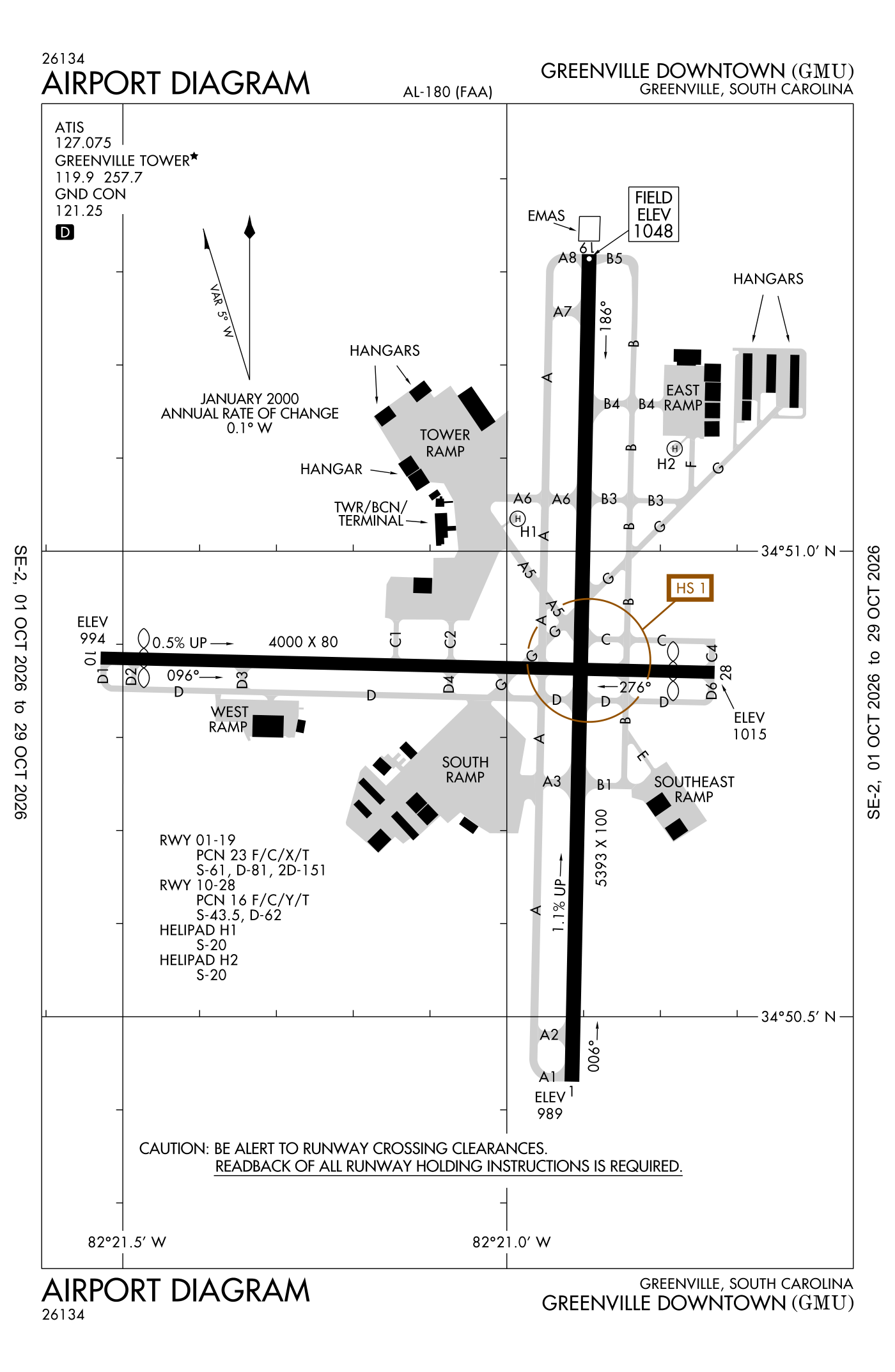
For understanding the field, not for navigation.
| Runway | Length × width | Surface | Lights |
|---|---|---|---|
| 01/19 | 5,393 × 100 ft | Asphalt, excellent | High-intensity lights |
| 10/28 | 4,000 × 80 ft | Asphalt, good | Medium-intensity lights |
| H1 | 50 × 50 ft | Concrete, good | Perimeter lights |
| H2 | 50 × 50 ft | Concrete, good | Perimeter lights |
- Runway 01: ILS, PAPI, four lights on the left, medium-intensity approach lights with flashers (MALSF), tree 35 ft high 1,247 ft from the end
- Runway 19: PAPI, four lights on the left, right-hand traffic pattern, tree 117 ft high 2,580 ft from the end
- Runway 10: threshold displaced 267 ft, 3,463 ft available for landing, tree 36 ft high 707 ft from the end
- Runway 28: PAPI, two lights on the left, right-hand traffic pattern, threshold displaced 271 ft, 3,463 ft available for landing, tree 31 ft high 444 ft from the end
Radio frequencies
| Common traffic advisory (CTAF) · Tower | 119.9 | Greenville |
| UNICOM | 122.95 | |
| ATIS (recorded airport information) · Gmu and automated weather (ASOS) | 127.075 | Greenville |
| Ground | 121.25 | Greenville |
| Approach and departure · Departure procedure (BIMMR) · Departure procedure (BWALL) | 118.8 | Greenville |
| Owing and center (remote transmitter) Low | 135.35 | Greenville |
Automated weather (ASOS), by phone 864-239-0014.
Based aircraft as counted for the FAA, fiscal year 2024
Based aircraft, as a table
| aircraft | |
|---|---|
| single-engine | 158 |
| multi-engine | 20 |
| jets | 21 |
| helicopters | 6 |
Takeoffs and landings a year about 79,438, the FAA's fiscal year 2024 (October 2023 to September 2024)
Takeoffs and landings, as a table
| a year | |
|---|---|
| airline | 2 |
| air taxi and commuter | 17,901 |
| general aviation, travelling | 44,496 |
| general aviation, local | 16,508 |
| military | 531 |
Local flights stay in the traffic pattern or nearby, often practice; travelling flights arrive from or leave for somewhere else. Counts at airports without a tower are the FAA's estimates. How this compares nationally: Airports by the numbers.
Wind map live wind over the area, from Windy.com
Colours show wind speed, the moving lines its direction; drag the time bar for the coming days. Map and forecast by Windy.com.
Aircraft registered in Greenville from the FAA register
126 aircraft are registered to owners in Greenville, South Carolina: 80 piston singles, 12 piston twins, 11 business jets, 9 turboprops, 5 balloons. Not every one of them is based at this airport; the based-aircraft count above is the FAA's figure for this airport alone.
Companies and organisations in town with two or more aircraft:
Individuals are counted, not named (the site's policy at this time). All aircraft registered in South Carolina.
Fuel and services as reported to the FAA
- Fuel
- 100LL avgas, Jet A
- Repairs
- airframe and engine: major repairs
- Parking
- hangars, tie-downs
- Oxygen
- bottled oxygen (high- and low-pressure), bulk oxygen (high- and low-pressure)
- Also here
- air ambulance, avionics, cargo handling, charter flights, flight instruction, aircraft rental, aircraft sales, aerial surveying
Other fields with jet fuel nearby: Donaldson Field (6 nm south), Greenville Spartanburg International (7 nm northeast), Pickens County (18 nm west).
The FAA's file records what is sold and done at the field, as the airport manager reports it, not who sells it or the price; fuel sellers (FBOs) are not named in any public file. Airports selling jet fuel in South Carolina · avgas.
Who works here from the FAA's certificate lists and the register
Charter operators and airlines based in Greenville:
- Axio Alpha, LLC 12 aircraft on the certificate Axio Alpha is a medical cargo, on-demand cargo, and passenger charter company operating throughout the United States and the Caribbean.
- Stratos Aviation LLC 4 aircraft on the certificate Stratos Aviation is a flight school with locations in Greenville and Columbia, South Carolina.
Repair stations in Greenville:
- Acl Airshop, LLC ACL Airshop is a worldwide provider of Unit Load Device (ULD) leasing, sales, repair, and control services for the aviation cargo industry.
- Applied Technical Services LLC
- Lockheed Martin Aircraft Center INC
- Pf Flyers INC
- Sai Flight Support, LLC.
- Southern Air Repair Corporation
- Stevens Aerospace and Defense Systems, LLC.
- Touch N Go Aeroworks LLC
- V1 Aircraft Services, LLC
Companies in the same town as this airport; not every one of them works from this field. All operators · all repair stations · all flight schools · all FBOs.
Examiners and inspectors nearby designated by the FAA · within 50 nautical miles
6 pilot examiners (the FAA's designated pilot examiners, who give the practical tests for pilot certificates) are based within 50 nautical miles: 6 for private pilot, 6 for commercial and instrument, 2 for airline transport pilot, 2 for flight instructor; 6 for airplanes, 3 for multi-engine airplanes. Also nearby: 2 sport aviation examiners, 14 aviation medical examiners, 4 mechanic examiners, 4 airworthiness representatives (manufacturing), 4 engineering representatives, 1 parachute rigger examiner, 2 training center examiners.
- Brett Avery Zukowski private pilot, commercial and instrument, airline transport pilot, flight instructor, instrument instructor; airplanes, multi-engine airplanes · Greenville, SC (0 nm) · (864) 201-9356 · bzukowski@usaeroflight.net
- Leonard Litton private pilot, commercial and instrument, flight instructor, instructor renewals, military competency; airplanes, multi-engine airplanes · Piedmont, SC (9 nm) · (703) 389-7709 · landslitton@gmail.com
- William Porcher Dubose private pilot, commercial and instrument; airplanes · Spartanburg Memorial Downtown Airport · Spartanburg, SC (20 nm) · (803) 256-3544 · info@scdpe.com
- Harrison Grady Smith private pilot, commercial and instrument; airplanes, multi-engine airplanes · Central, SC (23 nm) · (864) 986-9664 · harrisonsmith@me.com
- Gregory Collins private pilot, commercial and instrument, airline transport pilot; airplanes · Blue Ridge Sport Flight LLC · Hendersonville, NC (28 nm) · (828) 460-3646 · smokiescfi1@gmail.com
- David Alan Smith private pilot, commercial and instrument, instructor renewals, military competency, ground instructor, foreign pilot certificates; airplanes · Fletcher, NC (37 nm) · (828) 458-8484 · david@pitchvy.com
All 37 nearby, by kind, with contact details
What each kind does
- DPE: Designated Pilot Examiner: gives the practical tests (checkrides) for pilot certificates and ratings.
- SAE: Sport Aviation Examiner: gives the tests for sport pilot certificates and light-sport aircraft.
- AME: Aviation Medical Examiner: a doctor who issues the medical certificates pilots must hold.
- DME: Designated Mechanic Examiner: tests candidates for the mechanic certificate (airframe and powerplant).
- DAR-F: Designated Airworthiness Representative, manufacturing: issues airworthiness certificates for newly built aircraft and parts.
- DER-T: Designated Engineering Representative: approves engineering data for repairs and alterations on the FAA's behalf.
- DPRE: Designated Parachute Rigger Examiner: tests candidates for the parachute rigger certificate.
- DCTO-E: Designee at a certificated training organisation.
Designees are listed with the name and contact details the FAA publishes for them on its designee locator (read October 10, 2026): the FAA lists them so that pilots, mechanics and companies can find them. Private individuals are not named, the site's policy at this time. A designee who would rather not appear here can ask us through the contact address on the About page. Each designee is placed at the main public airport of the town the FAA lists (or the nearest one to its zip code), so "nearby" means the town, not an exact address. All examiners by state.
Accidents and incidents at or near this airport NTSB records · 26 since 1982, 4 fatal
Cases the NTSB recorded with this as the nearest airport, newest first. Each opens the full report in plain English. The country as a whole: Where accidents happen.
Nearby within 30 nautical miles
The FAA's remarks as written in the airport file, spelled out
- Airport existed prior to 1959; helipads are conditional. See airspace letter dated jan 24, 1990 for conditions.
- Aircraft oper in the Greenville airport traffic area south through east be alert for jet and conventional traffic des on the GREENVILLE-SPARTANBURG localizer crs.
- ATC-CTL. when the control tower closed activate malsf runway 01; runway end identifier lights runway 19; high-intensity runway lights runway 01/19; perimeter lights H1, H2, and taxiway lghts - the common traffic frequency. Runway end identifier lights runway 28; PAPI runway 01, 19, 28; medium-intensity runway lights runway 10/28 unavailable when tower closed.
- Pattern altitude: 800 feet above ground level for light aircraft, 1000 feet above ground level for hvy aircraft.
- Arresting gear/system: engineered material arresting system (emas) 157 feet in length by 113 feet in width at the departure end of runway 01.
- Mult trees 89 feet from runway 10 pavement end.
- Runway 10 approach is 28:1 at displaced thld.
- Runway 28 approach is 36:1 at displaced thld.
- Aircraft inbd from the ssw or on ILS runway 01 approach be alert for traffic 4.5 MI south operg in the donaldson field airport traffic pattern at 1800 feet or below.
- No overnight parking on helipads.
- No aircraft pmtd on taxiways 'C' or 'D' when aircraft gtr than 12500 pounds is operg on runway 10/28.
- Runway 10/28 rstrd to small aircraft (less than 12500 pounds) when aircraft operg on taxiways C or D.
Connections how this airport links to the rest of the register
- Aircraft registered in Greenville 126 aircraft · 80 piston singles, 12 piston twins, 11 business jets
- Usaeroflight LLC 7 aircraft in town
- Ataraxia Aircraft Holdings LLC 7 aircraft in town
- Wild Wingdom LLC 4 aircraft in town
- Greenville County Sheriffs Office 3 aircraft in town
- Axio Alpha, LLC 12 aircraft on the certificate · charter operator
- Stratos Aviation LLC 4 aircraft on the certificate · charter operator
- Acl Airshop, LLC · repair station
- Applied Technical Services LLC · repair station
- Lockheed Martin Aircraft Center INC · repair station
- Pf Flyers INC · repair station
- NTSB accidents and incidents at or near this airport 26 since 1982 · 4 fatal
- Accidents and incidents in South Carolina 1,035 since 1982 · 172 in the last ten years
- Nearby landing places within 30 nautical miles 8 airports, heliports and seaplane bases
- Public-use airports in South Carolina 67 landing places
- South Carolina 3,109 aircraft registered
The whole map of how records connect · these connections as data: /graph/airport/GMU.json.
Facts from the FAA's airport file effective October 1, 2026, written out in plain English; weather from the National Weather Service's aviation weather service; registered aircraft from the FAA register as of October 9, 2026; accidents from the NTSB's public database. Owners are shown only when they are an organisation; no person is named. Check the official sources before a flight: this page is for understanding an airport, not for planning one.