
Shreveport Downtown Airport
DTN · KDTN · Shreveport, Louisiana · Bossier County · map
Shreveport Downtown Airport is a public-use airport owned by Shreveport Arpt Authority, 3 miles north of Shreveport, Louisiana, 180 feet above sea level. It has 2 runways; the longest, 14/32, is 5,017 feet of asphalt. It has a control tower, fuel (100LL avgas, Jet A) and about 175 based aircraft. The FAA counts about 40,840 takeoffs and landings a year.
Quick answers answers refresh every morning
What is the airport code for Shreveport Downtown Airport?
Its FAA code is DTN, and its ICAO code is KDTN.
Where is Shreveport Downtown Airport?
It is 3 miles north of Shreveport, Louisiana, 180 feet above sea level.
How long is the longest runway at Shreveport Downtown Airport?
The longest of its 2 runways, 14/32, is 5,017 feet long.
Does Shreveport Downtown Airport have a control tower?
Yes, it has a control tower.
What fuel can you buy at Shreveport Downtown Airport?
The FAA's airport file lists 100LL avgas, Jet A.
Are there flight schools at Shreveport Downtown Airport?
5 flight schools, flying clubs or college flight programmes are based within about 15 miles of it, including Tubreaux Aviation Services LLC and Budget Flyers. Compare them
Where are the nearest FAA examiners to Shreveport Downtown Airport?
3 pilot examiners and 3 aviation medical examiners work within 50 nautical miles. See them by name
Weather and planning now, the forecast, warnings, pilot reports, winds aloft, restrictions
Weather right now KDTN · observed 9:53 am CDT (14:53 UTC), 9 minutes ago
VFR good flying weather
- Wind calm
- Visibility 10 miles or more
- Temperature 66°F (19°C), dew point 49°F (9°C)
- Altimeter 30.25 inHg
No terminal forecast is issued for this station. The nearest forecast is usually at the closest larger airport.
The codes as issued, and in English (METAR)
METAR KDTN 221453Z 00000KT 10SM CLR 19/09 A3025 RMK AO2 SLP241 T01890094 51014
- METAR
- a routine hourly observation
- KDTN
- the station, KDTN
- 221453Z
- observed 9:53 am CDT (14:53 UTC)
- 00000KT
- wind calm
- 10SM
- visibility 10 miles
- CLR
- clear skies
- 19/09
- temperature 19 °C (66 °F), dew point 9 °C (48 °F)
- A3025
- altimeter setting 30.25 inches of mercury
- RMK
- remarks follow
- AO2
- automated station with a precipitation sensor
- SLP241
- sea-level pressure 1024.1 hPa
- T01890094
- temperature 18.9 °C (66 °F), dew point 9.4 °C (49 °F)
- 51014
- pressure in the last three hours rising, then steady, change 1.4 hPa
From the National Weather Service's aviation weather service, refreshed every few minutes; times are local to the airport with UTC in brackets. For a flight, get your briefing from Flight Service or an approved provider.
Flight planning field conditions, warnings, pilot reports, winds aloft, restrictions · for planning, not a briefing
Field conditions now: elevation 180 ft, altimeter 30.25, 66°F (19°C; standard would be 15°C). Pressure altitude -150 ft. Density altitude 250 ft. The aircraft performs as if the field were at 250 feet: close to the field elevation. The air is 4 °C warmer than standard, so expect a somewhat longer takeoff run and a slower climb than at standard temperature.
| Runway | Length | Surface | Use end | Wind on it | Room for your book distance |
|---|---|---|---|---|---|
| 14/32 | 5,017 ft | asphalt | either | calm | |
| 05/23 | 4,198 ft | asphalt | either | calm |
Wind calm.
Pressure altitude is the field elevation corrected for today's altimeter setting; density altitude adds the effect of temperature. The aircraft's manual turns these into takeoff and landing distances, climb and fuel burn. Observation KDTN, 9:53 am CDT (14:53 UTC).
No SIGMET or AIRMET covers this field right now.
Turbulence No turbulence warning in force over this field. 4 pilot reports of turbulence within 100 nautical miles in the last three hours: light chop turbulence, at 36,000 ft, 86 nm east, 7:20 am CDT (12:20 UTC); light chop turbulence, at 36,000 ft, 95 nm southeast, 9:05 am CDT (14:05 UTC). The government's turbulence forecast map ↗
Icing No icing warning in force over this field. No pilot has reported icing within 100 nautical miles in the last three hours. The freezing level is about 14,000 ft (from the winds-aloft temperatures), so icing is possible in cloud above that. The government's icing forecast map ↗
9 pilot reports within 100 nautical miles in the last three hours, the nearest three:
- B712 at 34,000 ft, 7 nm southwest, 8:47 am CDT (13:47 UTC): no chop turbulence, remarks: ZFW89.
as filed, and in English
GGG UA /OV SHV/TM 1347/FL340/TP B712/TB NEG CHOP/RM ZFW89
- Report
- a routine report filed through GGG
- Where
- over SHV
- Time
- 13:47 UTC
- Height
- at 34,000 ft
- Aircraft
- B712
- Turbulence
- no chop
- Remarks
- ZFW89
- B738 at 41,000 ft, 37 nm east, 9:11 am CDT (14:11 UTC): clear from 41,000 ft to 60,000 ft, -55 °C, wind 335° at 39 knots, remarks: produced by skypath.
as filed, and in English
MNE UA /OV EMG056032 /TM 1411 /FL410 /TP B738 /SK SKC /WX FV99SM /TA M55 /WV 33539KT /RM PRODUCED BY SKYPATH
- Report
- a routine report filed through MNE
- Where
- 32 nm northeast (056°) of EMG
- Time
- 14:11 UTC
- Height
- at 41,000 ft
- Aircraft
- B738
- Sky
- clear
- Weather
- flight visibility 99 miles
- Temperature
- −55 °C
- Wind
- from 335° at 39 knots
- Remarks
- produced by skypath
- B712 at 34,000 ft, 52 nm west, 8:47 am CDT (13:47 UTC): no chop turbulence, remarks: ZFW89.
as filed, and in English
GGG UA /OV GGG/TM 1347/FL340/TP B712/TB NEG CHOP/RM ZFW89
- Report
- a routine report filed through GGG
- Where
- over GGG
- Time
- 13:47 UTC
- Height
- at 34,000 ft
- Aircraft
- B712
- Turbulence
- no chop
- Remarks
- ZFW89
Winds aloft at the nearest forecast point (SHV, 7 nm southwest), for use 14:00–21:00 UTC: 3,000 ft: 070° at 6 kt; 6,000 ft: 100° at 9 kt, 13 °C; 9,000 ft: 080° at 5 kt, 9 °C; 12,000 ft: 050° at 7 kt, 3 °C; 18,000 ft: 010° at 21 kt, -6 °C.
No temporary flight restriction within 50 nautical miles.
24 notices to air missions in force at this field.
All 24 notices, grouped: procedures and charts (2), obstructions (22) →
From the government's aviation weather service and the FAA's restriction list, refreshed every few minutes. This is for planning; the legal briefing comes from Flight Service or the FAA's own tools. The notices come from the FAA's notice service, the site's copy refreshed every few minutes (last checked 2 minutes ago). The FAA has so far issued eFlight its test feed, which misses some notices; the request for the full feed is with the FAA.
Wind map live wind over the area, from Windy.com
Colours show wind speed, the moving lines its direction; drag the time bar for the coming days. Map and forecast by Windy.com.
The airport facts, runways, radio, fuel and services, the FAA's remarks
The airport
- Codes
- FAA DTN · ICAO KDTN
- Kind
- Airport · open to the public · publicly owned
- Owner
- Shreveport Arpt Authority
- Elevation
- 180 feet above sea level
- Control tower
- A control tower · 7:00 am to 10:00 pm
- Attended
- every day, 7:00 am to 10:00 pm
- Lights
- runway lights sunset to sunrise; beacon sunset to sunrise
- Fuel and services
- 100LL avgas, Jet A; the services card below
- On the chart
- Memphis sectional
- Magnetic variation
- 1E
- In the FAA's files since
- April 1940
Runways 2
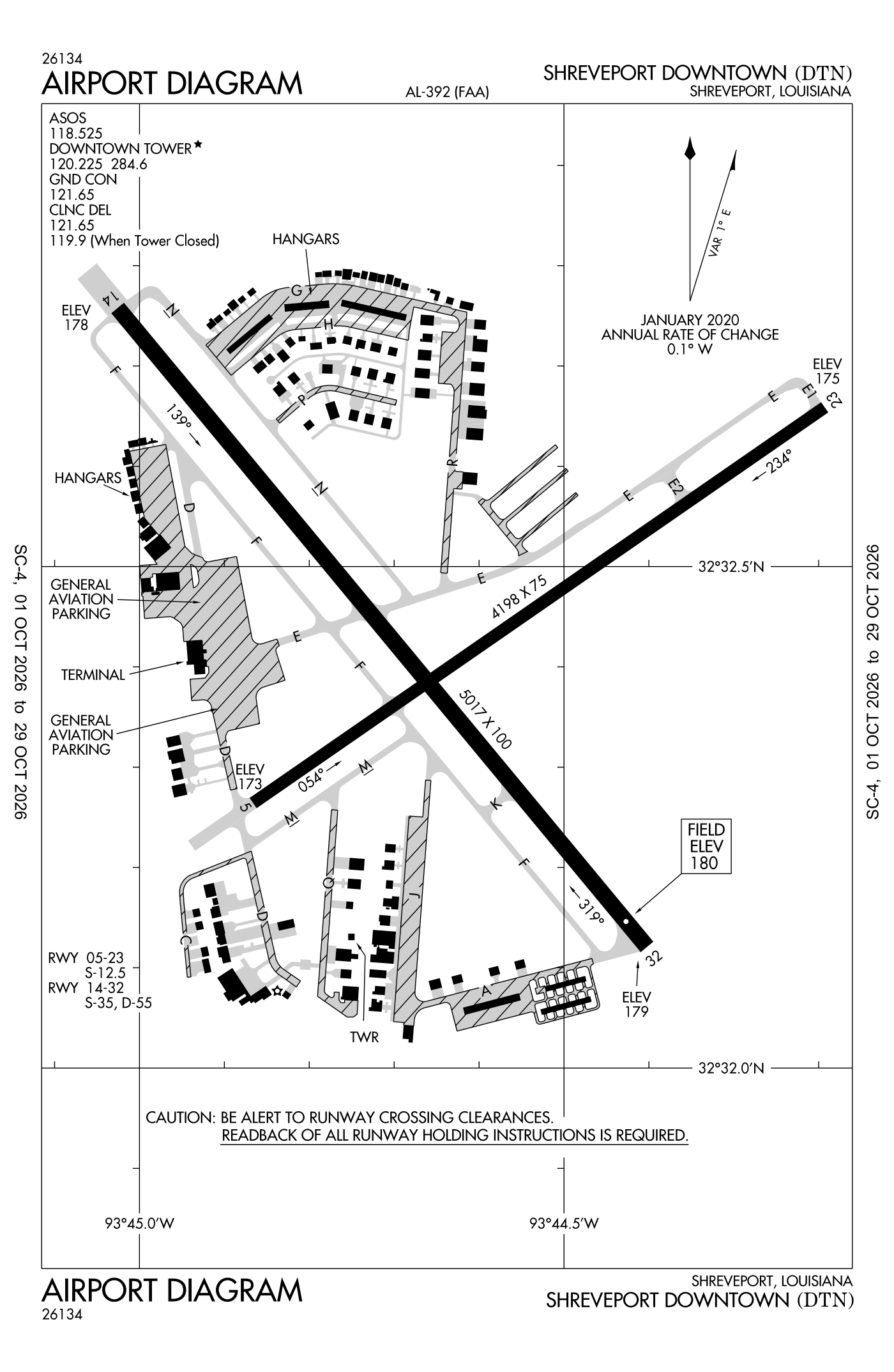
For understanding the field, not for navigation.
| Runway | Length × width | Surface | Lights |
|---|---|---|---|
| 14/32 | 5,017 × 100 ft | Asphalt, good | Medium-intensity lights |
| 05/23 | 4,198 × 75 ft | Asphalt, fair | Medium-intensity lights |
- Runway 14: localizer with DME, PAPI, four lights on the left, trees 63 ft high 1,844 ft from the end
- Runway 32: PAPI, four lights on the right, trees 79 ft high 2,226 ft from the end
- Runway 05: PAPI, two lights on the left, fence 6 ft high 200 ft from the end
- Runway 23: PAPI, two lights on the left, trees 40 ft high 1,800 ft from the end
Radio frequencies
| Common traffic advisory (CTAF) · Tower | 120.225 | Downtown |
| UNICOM | 122.95 | |
| Approach and departure · Clearance delivery arriving from headings 153 to 319; When tower closed | 119.9 | Downtown |
| Clearance delivery · Ground | 121.65 | Downtown |
| Approach and departure arriving from headings 320 to 152 | 123.75 | Downtown |
| Dtn and automated weather (ASOS) | 118.525 |
Automated weather (ASOS), by phone 318-425-7967.
Fuel and services as reported to the FAA
- Fuel
- 100LL avgas, Jet A
- Repairs
- airframe and engine: major repairs
- Parking
- hangars, tie-downs
- Oxygen
- bottled oxygen (high-pressure), bulk oxygen (low-pressure)
- Also here
- charter flights, flight instruction, aircraft rental
Other fields with jet fuel nearby: Shreveport Regional (7 nm southwest), Minden Airport (23 nm east), C E 'Rusty' Williams Airport (28 nm south).
The FAA's file records what is sold and done at the field, as the airport manager reports it, not who sells it or the price; fuel sellers (FBOs) are not named in any public file. Airports selling jet fuel in Louisiana · avgas.
The FAA's remarks as written in the airport file, spelled out
- All VFR traffic remain within 1 1/2 miles northeast through southwest from the center of the airport due to shreveport/barksdale afb class C airspace.
- 100LL available 24 hour self service with credit card.
- +6 feet fence 120 feet from runway end air carriers approach; +15 feet road 188 feet from runway end.
- PAPI unusable beyond 8 degreess right of centerline
- +15 feet road 188 feet from end of runway; approach slope 27:1 based on displaced thld.
- Runway 14 designated calm wind runway.
- Wildlife - deer and birds on and in the vicinity of airport.
Flights and activity in the air now, the airlines, based aircraft, takeoffs and landings
Activity now checking the volunteer receiver network…
Within ten miles
- Looking…
Arrivals and departures, last hour
- Looking…
From the volunteer receiver network, a few minutes behind at most; aircraft whose owners asked the FAA not to be displayed are left out; no person is named. Open the live map here.
Based aircraft as counted for the FAA, fiscal year 2024
Based aircraft, as a table
| aircraft | |
|---|---|
| single-engine | 144 |
| multi-engine | 23 |
| jets | 6 |
| other | 2 |
Takeoffs and landings a year about 40,840, the FAA's fiscal year 2024 (October 2023 to September 2024)
Takeoffs and landings, as a table
| a year | |
|---|---|
| airline | 1 |
| air taxi and commuter | 688 |
| general aviation, travelling | 19,220 |
| general aviation, local | 20,731 |
| military | 200 |
Local flights stay in the traffic pattern or nearby, often practice; travelling flights arrive from or leave for somewhere else. Counts at airports without a tower are the FAA's estimates. How this compares nationally: Airports by the numbers.
Who flies and works here aircraft registered in town, the companies, the examiners nearby
Aircraft registered in Shreveport from the FAA register
275 aircraft are registered to owners in Shreveport, Louisiana: 126 piston singles, 80 helicopters, 20 turboprops, 19 business jets, 18 piston twins. Not every one of them is based at this airport; the based-aircraft count above is the FAA's figure for this airport alone.
Companies and organisations in town with two or more aircraft:
Individuals are counted, not named (the site's policy at this time). All aircraft registered in Louisiana.
Who works here from the FAA's certificate lists and the register
Fuel and service companies in Shreveport, by their names on the register (a start, not a directory):
- Tubreaux Aviation Services LLC Tubreaux Aviation Services is a flight school, FBO, aircraft maintenance facility, and aircraft management company based in Shreveport, Louisiana.
- Hangar 21 Aviation LLC Hangar 21 Aviation provides flight training, aircraft ferry and repositioning services, aerial photography, and scenic tours in East Texas.
- Shreveport Aviation Services LLC
Flight schools, flying clubs and college flight programmes based within about 15 miles:
- Tubreaux Aviation Services LLC 5 aircraft · Shreveport Tubreaux Aviation is a flight school based in Shreveport, Louisiana that provides flight training from private pilot through CFI ratings, aircraft maintenance, aircraft management, and FBO services.
- Budget Flyers 1 aircraft · Shreveport
- 343 Aero Club 1 aircraft · Bossier City, 5 miles away
- Red River Aviators Flying Club 1 aircraft · Bossier City, 5 miles away
- Neu Aviation LLC 8 aircraft · Benton, 10 miles away Neu Aviation is a Part 61 flight school based in Shreveport, Louisiana, with additional locations in Ruston and Natchitoches.
Charter operators and airlines based in Shreveport:
- Metro Aviation, INC 185 aircraft on the certificate Metro Aviation operates more than 160 aircraft for over 40 air medical and other programs across 25 states.
- Flite Air Charter LLC 1 aircraft on the certificate Private FLITE Charters is a private jet charter broker that arranges charter flights worldwide through a network of licensed aircraft operators.
- Chem-Air, LLC 1 aircraft on the certificate Chem-Air is an aerial services company based in Shreveport, Louisiana, operating since 1973.
Repair stations in Shreveport:
- Metro Aviation, INC Metro Aviation is an aircraft operations, completions, and maintenance company based in Shreveport, Louisiana.
Companies in the same town as this airport, and schools within about 15 miles of it (each placed at the main public airport of its town, or at the town's centre); not every one of them works from this field. All operators · all repair stations · all flight schools · all FBOs.
Examiners and inspectors nearby designated by the FAA · within 50 nautical miles
3 pilot examiners (the FAA's designated pilot examiners, who give the practical tests for pilot certificates) are based within 50 nautical miles: 3 for private pilot, 3 for commercial and instrument, 3 for airline transport pilot, 3 for flight instructor, 1 for sport pilot; 3 for airplanes, 3 for multi-engine airplanes. Also nearby: 3 aviation medical examiners, 3 mechanic examiners, 2 airworthiness representatives (maintenance), 1 airworthiness representative (manufacturing), 1 aircraft dispatcher examiner, 1 training center examiner, 1 administrative pilot examiner.
- Dustin Wayne Howell private pilot, commercial and instrument, airline transport pilot, flight instructor, instrument instructor, sport pilot, instructor renewals, military competency, ground instructor, foreign pilot certificates; airplanes, multi-engine airplanes · Harrison County Airport KASL · Marshall, TX (29 nm) · (903) 371-0495 · [email protected]
- Bradley Frank Smith private pilot, commercial and instrument, airline transport pilot, flight instructor, instrument instructor; airplanes, multi-engine airplanes · LeTourneau UNIVERSITY · Longview, TX (50 nm) · (903) 269-7006 · [email protected]
- Bruce Allen Chase private pilot, commercial and instrument, airline transport pilot, flight instructor, instrument instructor, instructor renewals, military competency, ground instructor; airplanes, multi-engine airplanes · LeTourneau University · Longview, TX (50 nm) · (903) 261-4661 · [email protected]
All 15 nearby, by kind, with contact details
What each kind does
- DPE: Designated Pilot Examiner: gives the practical tests (checkrides) for pilot certificates and ratings.
- AME: Aviation Medical Examiner: a doctor who issues the medical certificates pilots must hold.
- DME: Designated Mechanic Examiner: tests candidates for the mechanic certificate (airframe and powerplant).
- DAR-T: Designated Airworthiness Representative, maintenance: issues airworthiness certificates and approvals for aircraft in service.
- DAR-F: Designated Airworthiness Representative, manufacturing: issues airworthiness certificates for newly built aircraft and parts.
- DADE: Designated Aircraft Dispatcher Examiner: tests candidates for the dispatcher certificate.
- DCTO-E: Designee at a certificated training organisation.
- Admin-PE: Administrative Pilot Examiner: handles certificate paperwork rather than flight tests.
Designees are listed with the name and contact details the FAA publishes for them on its designee locator (read October 10, 2026): the FAA lists them so that pilots, mechanics and companies can find them. Private individuals are not named, the site's policy at this time. A designee who would rather not appear here can ask us through the contact address on the About page. Each designee is placed at the main public airport of the town the FAA lists (or the nearest one to its zip code), so "nearby" means the town, not an exact address. All examiners by state.
Safety record the NTSB's cases at or near this airport
Accidents and incidents at or near this airport NTSB records · 14 since 1982, 4 fatal
Cases the NTSB recorded with this as the nearest airport, newest first. Each opens the full report in plain English. The country as a whole: Where accidents happen.
Nearby within 30 nautical miles
Connections how this airport links to the rest of the register
- Aircraft registered in Shreveport 275 aircraft · 126 piston singles, 80 helicopters, 20 turboprops
- Metro Aviation INC 69 aircraft in town
- Chem-Air LLC 8 aircraft in town
- Tubreaux Aviation Services LLC 5 aircraft in town
- Skyrunner LLC 5 aircraft in town
- Tubreaux Aviation Services LLC 5 aircraft · FBO or fuel seller
- Hangar 21 Aviation LLC 1 aircraft · FBO or fuel seller
- Shreveport Aviation Services LLC 1 aircraft · FBO or fuel seller
- Metro Aviation, INC 185 aircraft on the certificate · charter operator
- Flite Air Charter LLC 1 aircraft on the certificate · charter operator
- Chem-Air, LLC 1 aircraft on the certificate · charter operator
- Tubreaux Aviation Services LLC 5 aircraft · flight school
- Budget Flyers 1 aircraft · flight school
- 343 Aero Club 1 aircraft · flying club
- Metro Aviation, INC · repair station
- NTSB accidents and incidents at or near this airport 14 since 1982 · 4 fatal
- Accidents and incidents in Louisiana 1,272 since 1982 · 188 in the last ten years
- Nearby landing places within 30 nautical miles 8 airports, heliports and seaplane bases
- Public-use airports in Louisiana 72 landing places
- Louisiana 3,730 aircraft registered
The whole map of how records connect · these connections as data: /graph/airport/DTN.json.
Facts from the FAA's airport file effective October 1, 2026, written out in plain English; weather from the National Weather Service's aviation weather service; registered aircraft from the FAA register as of October 21, 2026; accidents from the NTSB's public database. Owners are shown only when they are an organisation; no person is named. Check the official sources before a flight: this page is for understanding an airport, not for planning one.