
Duke Fld,(Eglin AF Aux NR 3) Airport
EGI · KEGI · Crestview, Florida · Okaloosa County · map
Duke Fld,(Eglin AF Aux NR 3) Airport is a private airport owned by Usaf, 3 miles west of Crestview, Florida, 195 feet above sea level. Its one runway, 18/36, is 8,025 feet of asphalt and concrete. It has a control tower.
Private use: permission from the owner is required before landing here.
Weather right now KEGI · observed 4:55 pm CDT (21:55 UTC), 59 minutes ago
VFR good flying weather
- Wind from the northeast (050°) at 6 knots
- Visibility 10 miles or more
- Sky: a broken layer at 3,600 feet
- Temperature 80°F (26°C), dew point 70°F (21°C)
- Altimeter 29.88 inHg
The forecast issued Tue 12:00 pm CDT (17:00 UTC), good until Wed 6:00 pm CDT (23:00 UTC)
- From Tue 12:00 pm CDT (17:00 UTC): wind from the east-northeast at 12 knots, gusting to 18, overcast at 1,500 feet MVFR
- At times between Tue 1:00 pm CDT (18:00 UTC) and 5:00 pm CDT (22:00 UTC): wind from the east-northeast at 9 knots, light rain showers, a broken layer at 2,000 feet, overcast at 3,500 feet MVFR
- Changing between Tue 5:00 pm CDT (22:00 UTC) and 6:00 pm CDT (23:00 UTC) to: wind from the east-northeast at 6 knots, scattered clouds at 2,500 feet, overcast at 4,000 feet VFR
- Changing between Wed 10:00 am CDT (15:00 UTC) and 11:00 am CDT (16:00 UTC) to: wind from the northeast at 12 knots, gusting to 20, scattered clouds at 5,000 feet, a broken layer at 10,000 feet VFR
The codes as issued (METAR and TAF)
METAR KEGI 062155Z AUTO 05006KT 10SM BKN036 27/21 A2988 RMK AO2 SLP117 T02650212 FZRANO $
TAF KEGI 061700Z 0617/0723 07012G18KT 9999 OVC015 QNH2994INS TEMPO 0618/0622 06009KT 9000 -SHRA BKN020 OVC035 BECMG 0622/0623 07006KT 9999 SCT025 OVC040 QNH2988INS BECMG 0715/0716 05012G20KT 9999 SCT050 BKN100 QNH2993INS TX26/0621Z TN20/0712Z
From the National Weather Service's aviation weather service, refreshed every few minutes; times are local to the airport with UTC in brackets. For a flight, get your briefing from Flight Service or an approved provider.
The airport
- Codes
- FAA EGI · ICAO KEGI
- Kind
- Airport · private use, permission required · owned by the Air Force
- Owner
- Usaf
- Elevation
- 195 feet above sea level
- Control tower
- A control tower · 1445-0600z++ mon-fri except holidays, ot see far part 93.83 special air traffic rules.
- Attended
- Monday to Friday, 2:45 pm to 0600z++
- Lights
- runway lights sunset to sunrise; beacon sunset to sunrise
- Repairs
- airframe: none; engine: none
- On the chart
- New Orleans sectional
- Magnetic variation
- 3W
Runway
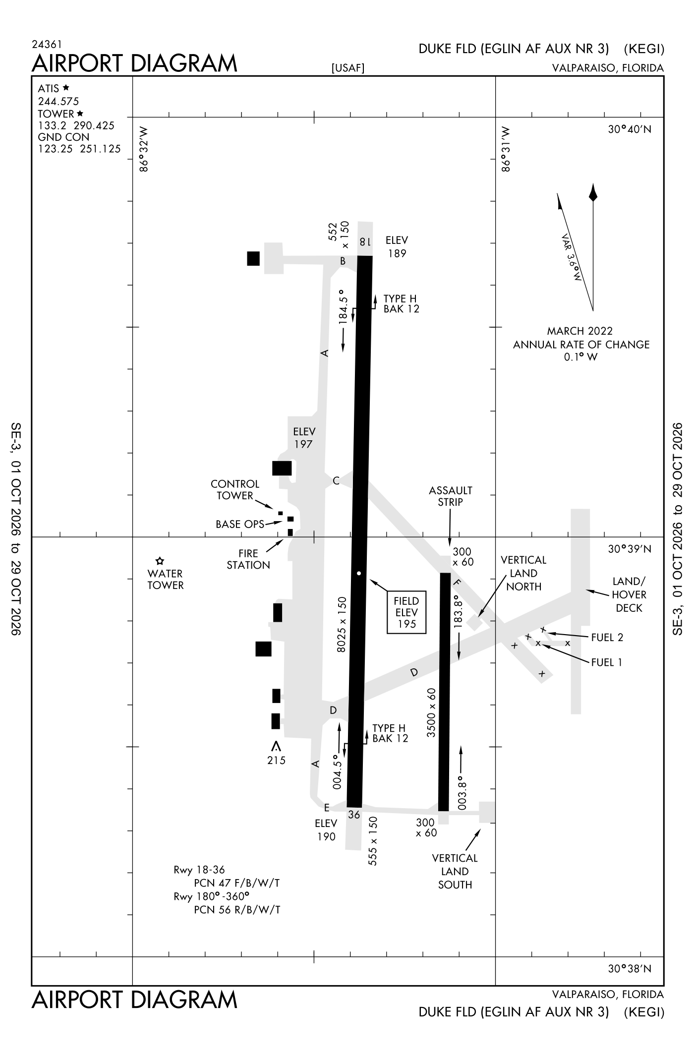
For understanding the field, not for navigation.
| Runway | Length × width | Surface | Lights |
|---|---|---|---|
| 18/36 | 8,025 × 150 ft | Asphalt and concrete | High-intensity lights |
- Runway 18: localizer and glideslope, PAPI, four lights on the left, approach lights with sequenced flashers (ALSF-1)
- Runway 36: PAPI, four lights on the left, SALSF
Radio frequencies
| Ground | 123.25 | Duke |
| Tower | 133.2 | Duke |
| Approach arriving from headings 271 to 089 | 125.1 | Duke |
| Approach arriving from headings 090 to 270 | 132.1 | Duke |
| Departure | 124.05 | Duke |
| Emergency | 121.5 | Duke |
| Comd and post | 138.437 | Duke |
Aircraft registered in Crestview from the FAA register
57 aircraft are registered to owners in Crestview, Florida: 31 piston singles, 7 business jets, 5 turboprops, 4 piston twins, 4 helicopters. Not every one of them is based at this airport; the based-aircraft count above is the FAA's figure for this airport alone.
Companies and organisations in town with two or more aircraft:
Individuals are counted, never named. All aircraft registered in Florida.
Accidents and incidents at or near this airport NTSB records
No NTSB accident or incident records name this airport.
Nearby within 30 nautical miles
The FAA's remarks as written in the airport file
- Rotating beacon out of service sunset to sunrise.
- Closed wkend and holidays. Base operations/air traffic control not manned OT.
- TYPE-H BAK-12B(B) (1260')
- TYPE-H BAK-12B(B) (1260')
- Runway 18/36 non-standard high-intensity runway lights edge lights located 75 feet from outside edge stripe.
- Pem: asphalt/concrete/macadam
- Cstms/agricultural/img: ltd service, no resident cstms agent. Available only to base asgn aircraft and 7TH special forces GP (7 sfg) apvd msn. 48 hour PN rqr. All other aircraft must clear cstms prior to arrival.
- Misc: exp no ntc closure of Duke field airspace for special msn test. Standard usaf rsrs applied. Base operations dsn 875-6516, C850-883-6516, nml operates wkd.
- MISC- weather operates 1400-0600Z++. remote briefing available 96 WS eglin afb, dsn 872-4800, C850-882-4800. Afld weather mnt by AN/FMO-19 automated weather (ASOS); augmented 1400-0600Z++ wkd, automated 0600-1400Z++ MON-FRI and H24 wkend/holidays. Afld visibility restricted to 1/8 SM to southwest and 1/4 SM west through northwest due to main base structures; maximum surface visibility mrk 1 SM (southeast). Night cloud cover viewing restricted due to surface light.
- SERVICE-LGT: runway 36 als non-standard (only high-intensity runway lights, thld, PRE-THLD, and term bar available). Runway 180 and runway 360 LZ non-standard afld mrk pattern (amp) light confign flashing strobe light(fsl) not on centerline. Fsls offset 30 feet to left at each end. Runway 18 PAPI rrp not coincidental with ILS rpi.
- Caution: HI volume of military training aircraft near cew vortac and in vicinity of bob sikes airport. Unlighted obstruction on afld. Due to lack of visual reference dur night VFR operates, pilot efforts to maintenance altitude by visual means may be unrel. North end non-standard ovrn (554 feet an X 150 feet). South end non-standard ovrn (556 feet an X 150 feet). Extv alz/nvd training in effective wkd.
- Misc: afld mowing season MAR-NOV. exp increased bird activity in the vicinity of mowers operating on afld.
Facts from the FAA's airport file effective October 1, 2026, written out in plain English; weather from the National Weather Service's aviation weather service; registered aircraft from the FAA register as of October 5, 2026; accidents from the NTSB's public database. Owners are shown only when they are an organisation; no person is named. Check the official sources before a flight: this page is for understanding an airport, not for planning one.