
Barking Sands Pmrf Airport
BKH · PHBK · Kekaha,Kauai, Hawaii · Kauai County · map
Barking Sands Pmrf Airport is a private airport owned by the US Navy, 5 miles northwest of Kekaha,Kauai, Hawaii, 23 feet above sea level. Its one runway, 16/34, is 6,002 feet of asphalt. It has a control tower.
Private use: permission from the owner is required before landing here.
Weather right now PHBK · observed 11:51 am HST (21:51 UTC), 17 minutes ago
VFR good flying weather
- Wind from the west (280°) at 5 knots
- Visibility 10 miles or more
- Temperature 82°F (28°C), dew point 65°F (18°C)
- Altimeter 29.92 inHg
No terminal forecast is issued for this station. The nearest forecast is usually at the closest larger airport.
The codes as issued (METAR and TAF)
METAR PHBK 062151Z AUTO 28005KT 10SM CLR 28/18 A2992 RMK AO2 SLP132 T02780183
From the National Weather Service's aviation weather service, refreshed every few minutes; times are local to the airport with UTC in brackets. For a flight, get your briefing from Flight Service or an approved provider.
The airport
- Codes
- FAA BKH · ICAO PHBK
- Kind
- Airport · private use, permission required · owned by the Navy
- Owner
- US Navy
- Elevation
- 23 feet above sea level
- Control tower
- A control tower · 7:00 am to 6:00 pm mon-fri except holidays, ot by ope nec only.
- Attended
- around the clock
- Lights
- runway lights see the remarks below; beacon sunset to sunrise
- On the chart
- Hawaiian Islands sectional
- Magnetic variation
- 10E
Runway
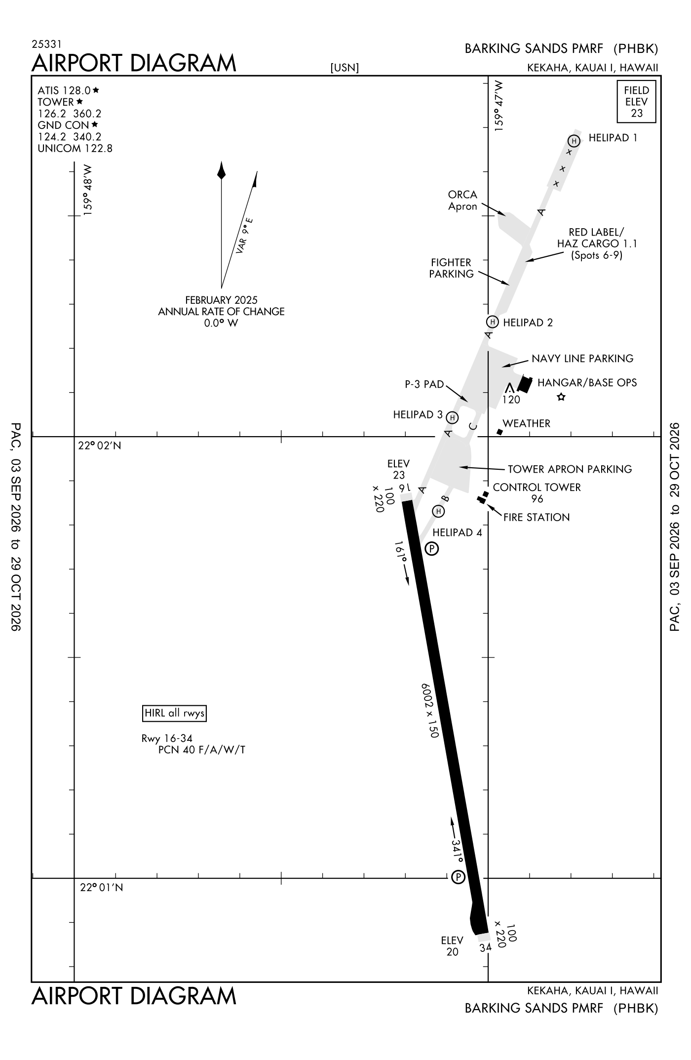
For understanding the field, not for navigation.
| Runway | Length × width | Surface | Lights |
|---|---|---|---|
| 16/34 | 6,002 × 150 ft | Asphalt | High-intensity lights |
- Runway 16: PAPI, four lights on the left
- Runway 34: PAPI, four lights on the left
Radio frequencies
| UNICOM | 122.8 | |
| ATIS (recorded airport information) | 128.0 | Navy Barking Sands |
| Ground | 124.2 | Navy Barking Sands |
| Tower | 126.2 | Navy Barking Sands |
| Emergency | 121.5 | Navy Barking Sands |
| Mount Kaala Center (remote transmitter) Low/high | 126.5 | Navy Barking Sands |
Aircraft registered in Kekaha,Kauai from the FAA register
No aircraft on the register list Kekaha,Kauai, HI as the owner's town.
Accidents and incidents at or near this airport NTSB records · 1 since 1982, 1 fatal
Cases the NTSB recorded with this as the nearest airport, newest first. Each opens the full report in plain English.
Nearby within 30 nautical miles
The FAA's remarks as written in the airport file
- Available only during hours of operation.
- Operates 1700-0400Z MON-FRI except holidays. OT by operates nec only.
- NS abtmt - north shoreline Kauai and the island of nihau extremely noise sensitive, aircraft avoid by at least 5 NM.
- A+ available 1700-0430Z MON-FRI, closed Saturday, Sunday and holidays.
- Caution - extv R/west external load traffic. Bird haz.
- Misc - crash crew can nml provide cat 2 minimum response, ltd cat 3 minimum response available.
- RWY-LGTS: runway 16 and runway 34 - ols.
- Misc - extremely ltd tow capability; aircrew must provide qualified driver for tow veh. No air stairs. No lavatory service. No flight planning service. Aerodrome ltd to msn essential passenger only. No SPACE-A support.
- Service: fuel - ltd to 50K for transient aircraft and only DD form 1896 (jet fuel indentaplate) accepted. R/west hot refuel rqr crew member to connect fuel hose to aircraft. R/west (west/skids) and F/west cold fuel only.
- Caution (1 of 2) - numerous unlit obstruction within runway safety zones and approach/departure clear zones. Sand berms, trees and vegetation located 152' west of centerline extending full length of runway and into runway 16 and 34 approach zones. Vegetation located 57' west of pavement edge stripes for turn around area at south end of runway. Trees and vegetation located 250' east of centerline extending into runway 34 approach zone. Kinikini ditch (15' deep an X 50' wide) located 150' south of runway 34 thld extending FR ocean around the runway to the east with routine bird act. Vegetation located 135' north of runway 16 thld extending into runway 16 approach zone. Aircraft on taxiway alpha at runway hold posn are within the runway 16/34 approach/departure clear zones. No taxiway guidance signs; required progressive taxi if reqrd. Use caution for reduced braking action on all taxiways and aprons dur dry conditions, use extra caution dur wet conditions. Taxiway bravo pcn 31 F/a/west/T; 65' wide, limited to C-130 (wingspan 134') or smaller aircraft, and unlit, 2' tall obstruction (pentagraph refueling pipe) located 34' east of centerline adjacent to helipad 4. Aircraft carrying hazardous cargo restricted to pcn 41 F/a/west/T due to taxiway alpha load brg change north of tower apron. Ftr parking pcn 36 F/a/west/T. navy line parking pcn 31 F/a/west/T.
- Caution (2 of 2) - tower apn pcn 51 F/a/west/T; concrete portion pcn 49 R/C/west/T. fresh water rinse facility located at north end of concrete portion. Aircraft wash rack pcn 31 F/a/west/T located adjacent to fabric hangar. Helipad 1 (100'X100') ltd to locally assigned aircraft. Helipads 2 and 3 (70'X70') located on taxiway alpha adjacent to navy line parking apron. Helipad 4 (59'X59') located on taxiway bravo and used for hot refuel.
- Service light: PAPI runway 16/34 installed with 3 degree glide angle and 40 feet threshold crossing height for aircraft west/wheel to cockpit height of 10 feet or less.
Facts from the FAA's airport file effective October 1, 2026, written out in plain English; weather from the National Weather Service's aviation weather service; registered aircraft from the FAA register as of October 5, 2026; accidents from the NTSB's public database. Owners are shown only when they are an organisation; no person is named. Check the official sources before a flight: this page is for understanding an airport, not for planning one.