
Biggs Army Airfield (Fort Bliss)
BIF · KBIF · Fort Bliss/El Paso/, Texas · El Paso County · map
Biggs Army Airfield (Fort Bliss) is a private airport owned by the US Army Aeronautical Svcs Agency, 5 miles northeast of Fort Bliss/El Paso/, Texas, 3,947 feet above sea level. Its one runway, 04/22, is 13,554 feet of concrete. It has a control tower and fuel (Jet A with additives).
Private use: permission from the owner is required before landing here.
Weather right now KBIF · observed 3:55 pm MDT (21:55 UTC), 12 minutes ago
VFR good flying weather
- Wind from the north-northwest (340°) at 4 knots
- Visibility 10 miles or more
- Temperature 82°F (28°C), dew point 55°F (13°C)
- Altimeter 30.06 inHg
The forecast issued Tue 1:00 pm MDT (19:00 UTC), good until Wed 7:00 pm MDT (01:00 UTC)
- From Tue 1:00 pm MDT (19:00 UTC): wind light and variable, scattered clouds at 6,000 feet
The codes as issued (METAR and TAF)
METAR KBIF 062155Z AUTO 34004KT 10SM CLR 28/13 A3006 RMK AO2 SLP118 T02790126 $
TAF KBIF 061900Z 0619/0801 VRB06KT 9999 SCT060 510206 QNH3007INS TX27/0619Z TN16/0709Z
From the National Weather Service's aviation weather service, refreshed every few minutes; times are local to the airport with UTC in brackets. For a flight, get your briefing from Flight Service or an approved provider.
The airport
- Codes
- FAA BIF · ICAO KBIF
- Kind
- Airport · private use, permission required · owned by the Army
- Owner
- US Army Aeronautical Svcs Agency
- Elevation
- 3,947 feet above sea level
- Control tower
- A control tower · 1500-0700z++ mon-sun except holidays
- Attended
- Monday to Sunday, 3:00 pm to 0700z++; every day, except holidays
- Lights
- runway lights see the remarks below; beacon sunset to sunrise
- Fuel
- Jet A with additives
- On the chart
- El Paso sectional
- Magnetic variation
- 8E
Runway
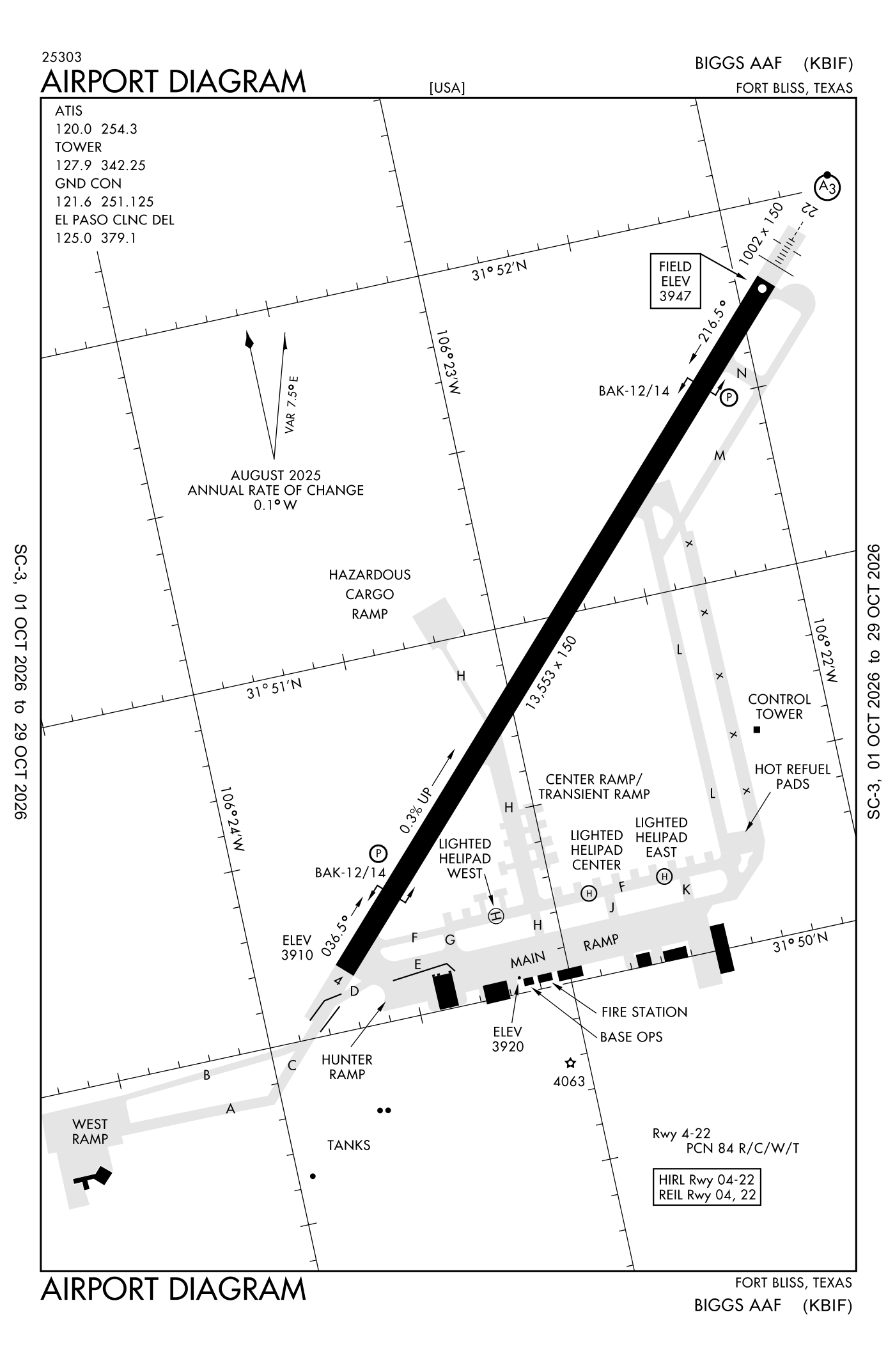
For understanding the field, not for navigation.
| Runway | Length × width | Surface | Lights |
|---|---|---|---|
| 04/22 | 13,554 × 150 ft | Concrete, good | High-intensity lights |
- Runway 04: PAPI, four lights on the left
- Runway 22: ILS with DME, PAPI, four lights on the left, short approach lights with alignment lights (SSALR), right-hand traffic pattern
Radio frequencies
| Clearance delivery | 125.0 | Biggs |
| Ground | 121.6 | Biggs |
| Tower | 127.9 | Biggs |
| Approach · Class C airspace SOUTH-V16 | 119.15 | Biggs |
| Approach · Class C airspace · Departure NORTH-V16 | 124.25 | Biggs |
| Emergency | 121.5 | Biggs |
| Pre-taxi clearance | 126.2 | Biggs |
| Operations Biggs aic | 134.1 | Biggs |
Aircraft registered in Fort Bliss/El Paso/ from the FAA register
No aircraft on the register list Fort Bliss/El Paso/, TX as the owner's town.
Accidents and incidents at or near this airport NTSB records
No NTSB accident or incident records name this airport.
Nearby within 30 nautical miles
The FAA's remarks as written in the airport file
- Restricted: prior permission required all aircraft 24 hour PN required, contact airfield operations dsn 621-8811/8330, C915-744-8811/8330. Tower and services available for all aircraft with prior permission required. Prior permission required time valid +/-1 hour. All aircraft contact afld operations via ptd 30 minimum prior to arrival. Flight operations and tran alert service unavailable bfr 1 hour prior to prior permission required schedule arrival.
- SERVICE-LGT: when unatndd activate runway end identifier lights runway 04; PAPI runway 04 and 22; high-intensity runway lights runway 04/22 - 127.9.
- BAK-14 BAK-12B(B) (1500').
- BAK-14 BAK-12B(B) (2100').
- Traffic pattern: F/west 5000', turbo prop 5500', R/west 4500', jet 6000'.
- Caution: El Paso international runway 22, 2 NM southeast can be mistaken for Biggs Aaf runway 22. Coyote haz.
- NS abtmt: VFR west arrival/departure via mtn pass 15 NM northwest of Biggs Aaf. Avoid VFR ovft of city. Fly 1500 feet above ground level, 1500 feet horizontal dist from mtn dwellings.
- Bearing strength runway 04/22: ST175 SBTT593 TRT585.
- See flip AP/1 supplementary airport rmk.
- Jasu: 4(A/M32A-86) 2(A/M32-95).
- Fluid: SP.
- Misc: apvl rqr for access to ramp.
Facts from the FAA's airport file effective October 1, 2026, written out in plain English; weather from the National Weather Service's aviation weather service; registered aircraft from the FAA register as of October 5, 2026; accidents from the NTSB's public database. Owners are shown only when they are an organisation; no person is named. Check the official sources before a flight: this page is for understanding an airport, not for planning one.