
Joint Base Andrews
ADW · KADW · Camp Springs, Maryland · Prince Georges County · map
Joint Base Andrews is a private airport owned by Usaf, 3 miles east of Camp Springs, Maryland, 280 feet above sea level. It has 2 runways; the longest, 01L/19R, is 11,301 feet of concrete. It has a control tower. The FAA counts about 48,591 takeoffs and landings a year. About 280 passengers boarded flights here in the FAA's fiscal year 2024.
Private use: permission from the owner is required before landing here.
The airport
- Codes
- FAA ADW · ICAO KADW
- Kind
- Airport · private use, permission required · owned by the Air Force
- Owner
- Usaf
- Elevation
- 280 feet above sea level
- Control tower
- A control tower · around the clock
- Attended
- around the clock
- Lights
- beacon sunset to sunrise
- Fuel and services
- no fuel reported; the services card below
- On the chart
- Washington sectional
- Magnetic variation
- 10W
- In the FAA's files since
- February 1944
Runways 2
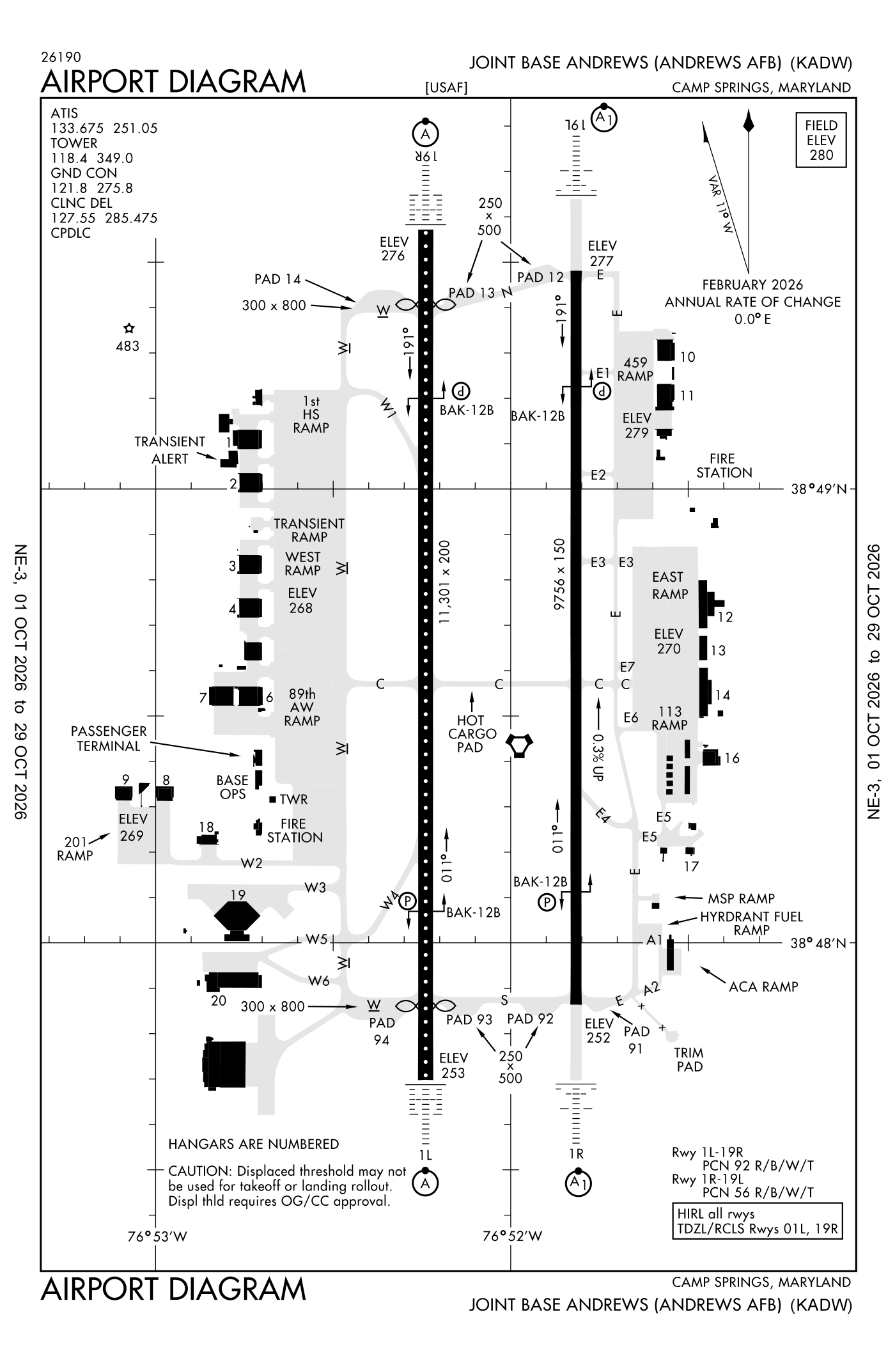
For understanding the field, not for navigation.
| Runway | Length × width | Surface | Lights |
|---|---|---|---|
| 01L/19R | 11,301 × 200 ft | Concrete | High-intensity lights |
| 01R/19L | 9,756 × 150 ft | Asphalt and concrete | High-intensity lights |
- Runway 01L: ILS, PAPI, four lights on the left, approach lights with sequenced flashers (ALSF-2), threshold displaced 991 ft
- Runway 19R: ILS, PAPI, four lights on the left, approach lights with sequenced flashers (ALSF-2), threshold displaced 992 ft
- Runway 01R: localizer and glideslope, PAPI, four lights on the left, approach lights with sequenced flashers (ALSF-1)
- Runway 19L: localizer and glideslope, PAPI, four lights on the left, approach lights with sequenced flashers (ALSF-1)
Radio frequencies
| Digital ATIS | 133.675 | Andrews |
| Clearance delivery | 127.55 | Andrews |
| Ground | 121.8 | Andrews |
| Tower | 118.4 | Andrews |
| Approach | 128.0 | Andrews |
| Departure · Departure procedure (JEFSN) · Departure procedure (LINCN) West | 118.95 | Andrews |
| Departure East | 125.65 | Andrews |
| Emergency | 121.5 | Andrews |
| Frdmm and star · Nummy and star · Trups and star | 118.675 | Andrews |
| Tikee and star | 120.45 | Andrews |
| Ground-controlled approach | 125.35 | Andrews |
| Vudoo and star | 126.4 | Andrews |
| Spisy and star | 133.75 | Andrews |
| Comd and post | 141.55 | Andrews |
| Afrc and operations | 143.8 | Andrews |
Based aircraft as counted for the FAA, fiscal year 2024
No based-aircraft count is published for this airport.
Takeoffs and landings a year about 48,591, the FAA's fiscal year 2024 (October 2023 to September 2024)
Takeoffs and landings, as a table
| a year | |
|---|---|
| airline | 450 |
| air taxi and commuter | 538 |
| general aviation, travelling | 2,917 |
| general aviation, local | 22 |
| military | 44,664 |
Local flights stay in the traffic pattern or nearby, often practice; travelling flights arrive from or leave for somewhere else. Counts at airports without a tower are the FAA's estimates. How this compares nationally: Airports by the numbers.
Aircraft registered in Camp Springs from the FAA register
No aircraft on the register list Camp Springs, MD as the owner's town.
Fuel and services as reported to the FAA
- Fuel
- none reported
- Repairs
- airframe and engine: major repairs
- Parking
- hangars
- Oxygen
- bulk oxygen (low-pressure)
- Also here
- cargo handling
Nearest fields reporting jet fuel: South Capitol Street Heliport (7 nm northwest), Ronald Reagan Washington Ntl Airport (8 nm west), College Park Airport (11 nm north), Maryland Airport (16 nm southwest).
Nearest fields reporting avgas: Potomac Airfield (6 nm southwest), Freeway Airport (9 nm northeast), College Park Airport (11 nm north), Maryland Airport (16 nm southwest).
The FAA's file records what is sold and done at the field, as the airport manager reports it, not who sells it or the price; fuel sellers (FBOs) are not named in any public file. Airports selling jet fuel in Maryland · avgas.
Accidents and incidents at or near this airport NTSB records · 5 since 1982, 1 fatal
Cases the NTSB recorded with this as the nearest airport, newest first. Each opens the full report in plain English. The country as a whole: Where accidents happen.
Nearby within 30 nautical miles
The FAA's remarks as written in the airport file, spelled out
- Bearing strength runway 01L/19R: S85 T220 ST175 SBTT518 TT327 TDT840 DDT800 TRT556.
- Overhead pattern 2000(1720), rectangular pattern 1500(1220), light aircraft and helicopter 1000(720).
- 1BAK-14 BAK-12B(B) (1240 feet).
- BAK-14 BAK-12B(B) (1500 feet).
- BAK-14 BAK-12B(B) (1537 feet).
- BAK-14 BAK-12B(B) (2240 feet).
- Runway 19R avl takeoff dist incl hardened ovrn is 10918 feet an X 200 feet.
- Bearing strength runway 01R/19L: S85 T205 ST175 TT380 TDT800 DDT800.
- Aoe.
- Service: light: runway 01L/19R visual glideslope indicator and ILS glidepath not coincidental. Runway 01L/19R PAPI set for height group 4. Runway 01R/19L PAPI set for height group 4.
- SERVICE-A-GEAR: runway 01R-19L north and south MB60 A-G unsvc.
- Jasu: (A/M32A-86) 9(AM32-95).
Connections how this airport links to the rest of the register
- NTSB accidents and incidents at or near this airport 5 since 1982 · 1 fatal
- Accidents and incidents in Maryland 836 since 1982 · 110 in the last ten years
- Nearby landing places within 30 nautical miles 8 airports, heliports and seaplane bases
- Public-use airports in Maryland 34 landing places
- Maryland 2,341 aircraft registered
The whole map of how records connect · these connections as data: /graph/airport/ADW.json.
Facts from the FAA's airport file effective October 1, 2026, written out in plain English; weather from the National Weather Service's aviation weather service; registered aircraft from the FAA register as of October 9, 2026; accidents from the NTSB's public database. Owners are shown only when they are an organisation; no person is named. Check the official sources before a flight: this page is for understanding an airport, not for planning one.