
Little Rock Air Force Base
LRF · KLRF · Jacksonville, Arkansas · Pulaski County · map
Little Rock Air Force Base is a private airport owned by Usaf, Mac, 1 mile southeast of Jacksonville, Arkansas, 312 feet above sea level. It has 2 runways; the longest, 07/25, is 12,001 feet of concrete. It has a control tower.
Private use: permission from the owner is required before landing here.
The airport
- Codes
- FAA LRF · ICAO KLRF
- Kind
- Airport · private use, permission required · owned by the Air Force
- Owner
- Usaf, Mac
- Elevation
- 312 feet above sea level
- Control tower
- A control tower · around the clock
- Attended
- around the clock
- Lights
- runway lights sunset to sunrise; beacon sunset to sunrise
- Fuel and services
- no fuel reported; the services card below
- On the chart
- Memphis sectional
- Magnetic variation
- 1W
Runways 2
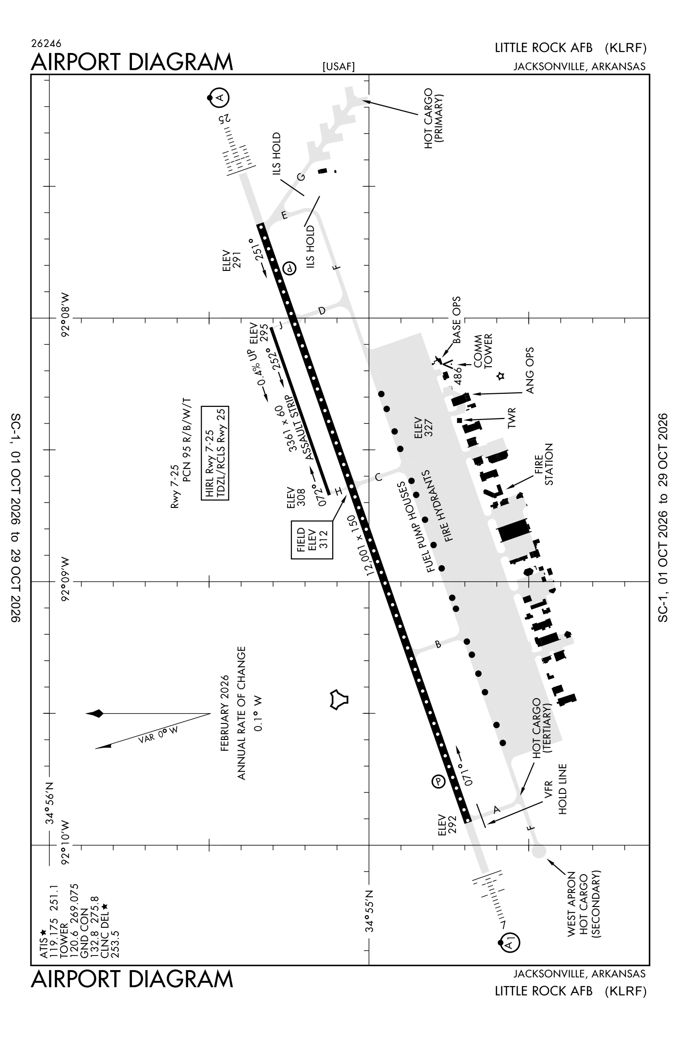
For understanding the field, not for navigation.
| Runway | Length × width | Surface | Lights |
|---|---|---|---|
| 07/25 | 12,001 × 150 ft | Concrete, good | High-intensity lights |
| 071/251 | 3,354 × 60 ft | Concrete |
- Runway 07: PAPI, four lights on the left, approach lights with sequenced flashers (ALSF-1)
- Runway 25: ILS, PAPI, four lights on the left, approach lights with sequenced flashers (ALSF-2), right-hand traffic pattern
Radio frequencies
| ATIS (recorded airport information) | 119.175 | Little Rock |
| Ground | 132.8 | Little Rock |
| Tower | 120.6 | Little Rock |
| Approach and departure | 119.5 | Little Rock |
| Ang and operations Hawg operations | 138.6 | Little Rock |
Aircraft registered in Jacksonville from the FAA register
16 aircraft are registered to owners in Jacksonville, Arkansas: 13 piston singles, 1 weight-shift or powered parachute, 1 helicopter, 1 drone. Not every one of them is based at this airport; the based-aircraft count above is the FAA's figure for this airport alone.
Companies and organisations in town with two or more aircraft:
Individuals are counted, not named (the site's policy at this time). All aircraft registered in Arkansas.
Fuel and services as reported to the FAA
- Fuel
- none reported
- Parking
- hangars
- Also here
- cargo handling
Nearest fields reporting jet fuel: North Little Rock Municipal (7 nm southwest), Bill And Hillary Clinton Ntl/Adams Field (12 nm south), Conway Regional (21 nm west), Saline County Regional (26 nm southwest).
Nearest fields reporting avgas: North Little Rock Municipal (7 nm southwest), Bill And Hillary Clinton Ntl/Adams Field (12 nm south), Conway Regional (21 nm west), Carlisle Municipal (22 nm east).
The FAA's file records what is sold and done at the field, as the airport manager reports it, not who sells it or the price; fuel sellers (FBOs) are not named in any public file. Airports selling jet fuel in Arkansas · avgas.
Accidents and incidents at or near this airport NTSB records
No NTSB accident or incident records name this airport.
Nearby within 30 nautical miles
The FAA's remarks as written in the airport file, spelled out
- Restricted: prior permission required except airevac and armed forces courier.
- Rectangular 1400 feet, ovhd 1900 feet.
- Airport nmly closed fed holidays from 0400Z++ or last land, through 1300Z++ succeeding day.
- Caution: extv TURBO-PROP training 1300-0600Z++ MON-FRI.
- Caution: phase II in effective APR-MAY and SEP-NOV.
- Restricted: no practice approach or landing dur local flying.
- NS abtmt - departure hvy aircraft climb runway hdg to 1500' above ground level prior to turning on crs.
- Caution: significant increase in bird act APR-MAY, SEP-NOV.
- Caution: deer haz.
- Caution: HI potential for hydroplaning on runway 07-25 dur periods of wet weather.
- Caution: numerous unlighted obstruction located prim surface.
- Caution: non-standard runway MRK- assault strip mrk (500' an X 60') painted on runway 25.
Connections how this airport links to the rest of the register
- Aircraft registered in Jacksonville 16 aircraft · 13 piston singles, 1 weight-shift and powered parachutes, 1 helicopters
- Nick Franke LLC 2 aircraft in town
- Accidents and incidents in Arkansas 1,580 since 1982 · 176 in the last ten years
- Nearby landing places within 30 nautical miles 8 airports, heliports and seaplane bases
- Public-use airports in Arkansas 101 landing places
- Arkansas 3,490 aircraft registered
The whole map of how records connect · these connections as data: /graph/airport/LRF.json.
Facts from the FAA's airport file effective October 1, 2026, written out in plain English; weather from the National Weather Service's aviation weather service; registered aircraft from the FAA register as of October 9, 2026; accidents from the NTSB's public database. Owners are shown only when they are an organisation; no person is named. Check the official sources before a flight: this page is for understanding an airport, not for planning one.