
Homestead Arb Airport
HST · KHST · Homestead, Florida · Dade County · map
Homestead Arb Airport is a private airport owned by Usaf - Homestead Arb, 3 miles east of Homestead, Florida, 6 feet above sea level. Its one runway, 06/24, is 11,202 feet of concrete. It has a control tower.
Private use: permission from the owner is required before landing here.
Weather right now KHST · observed 5:55 pm EDT (21:55 UTC), 57 minutes ago
VFR good flying weather
- Wind from the southeast (130°) at 4 knots
- Visibility 10 miles or more
- Temperature 86°F (30°C), dew point 72°F (22°C)
- Altimeter 29.82 inHg
The forecast issued Tue 3:00 pm EDT (19:00 UTC), good until Wed 9:00 pm EDT (01:00 UTC)
- From Tue 3:00 pm EDT (19:00 UTC): wind from the south at 9 knots, showers nearby, scattered clouds at 3,000 feet, a broken layer at 5,000 feet and more above VFR
- At times between Tue 4:00 pm EDT (20:00 UTC) and 6:00 pm EDT (22:00 UTC): wind variable at 15 knots, gusting to 25, light rain showers, thunderstorms nearby, a broken layer at 2,500 feet (thunderheads) MVFR
- Changing between Tue 6:00 pm EDT (22:00 UTC) and 7:00 pm EDT (23:00 UTC) to: wind light and variable, a few clouds at 3,000 feet, scattered clouds at 6,000 feet and more above
- Changing between Wed 6:00 am EDT (10:00 UTC) and 7:00 am EDT (11:00 UTC) to: wind from the south-southwest at 7 knots, a few clouds at 2,500 feet, scattered clouds at 5,500 feet and more above VFR
- Changing between Wed 11:00 am EDT (15:00 UTC) and 12:00 pm EDT (16:00 UTC) to: wind from the south-southwest at 9 knots, light rain showers, scattered clouds at 2,500 feet, a broken layer at 4,000 feet VFR
- At times between Wed 2:00 pm EDT (18:00 UTC) and 5:00 pm EDT (21:00 UTC): wind variable at 12 knots, gusting to 18, light thunderstorms with rain, a broken layer at 2,000 feet (thunderheads) MVFR
- Changing between Wed 6:00 pm EDT (22:00 UTC) and 7:00 pm EDT (23:00 UTC) to: wind light and variable, a few clouds at 1,500 feet, scattered clouds at 2,500 feet
The codes as issued (METAR and TAF)
METAR KHST 062155Z AUTO 13004KT 10SM CLR 30/22 A2982 RMK AO2 LTG DSNT NW-N SLP101 T03000224
TAF KHST 061900Z 0619/0801 17009KT 9999 VCSH SCT030 BKN050 BKN180 QNH2984INS TEMPO 0620/0622 VRB15G25KT 8000 -SHRA VCTS BKN025CB BECMG 0622/0623 VRB06KT 9999 NSW FEW030 SCT060 SCT200 QNH2983INS BECMG 0710/0711 20007KT 9999 FEW025 SCT055 BKN200 QNH2984INS BECMG 0715/0716 20009KT 8000 -SHRA SCT025 BKN040 QNH2980INS TEMPO 0718/0721 VRB12G18KT 4800 -TSRA BKN020CB BECMG 0722/0723 VRB03KT 9999 NSW FEW015 SCT025 QNH2981INS TX31/0619Z TN25/0710Z
From the National Weather Service's aviation weather service, refreshed every few minutes; times are local to the airport with UTC in brackets. For a flight, get your briefing from Flight Service or an approved provider.
The airport
- Codes
- FAA HST · ICAO KHST
- Kind
- Airport · private use, permission required · owned by the Air Force
- Owner
- Usaf - Homestead Arb
- Elevation
- 6 feet above sea level
- Control tower
- A control tower with approach control · around the clock
- Attended
- around the clock
- Lights
- runway lights sunset to sunrise; beacon sunset to sunrise
- Repairs
- airframe: none; engine: none
- On the chart
- Miami sectional
- Magnetic variation
- 6W
- In the FAA's files since
- August 1942
Runway
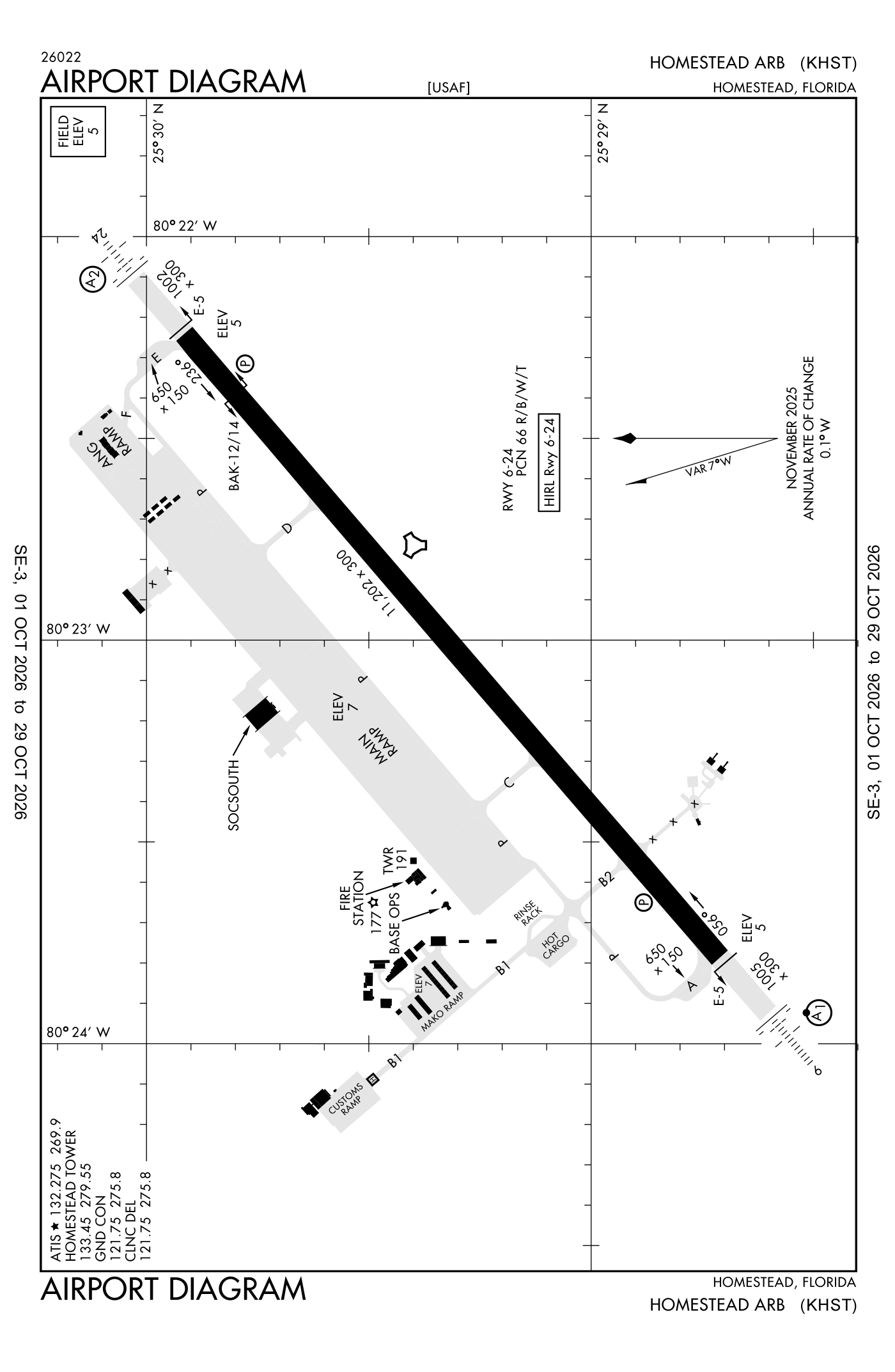
For understanding the field, not for navigation.
| Runway | Length × width | Surface | Lights |
|---|---|---|---|
| 06/24 | 11,202 × 300 ft | Concrete | High-intensity lights |
- Runway 06: ILS, PAPI, four lights on the left, approach lights with sequenced flashers (ALSF-1), right-hand traffic pattern
- Runway 24: PAPI, four lights on the left, SALS
Radio frequencies
| ATIS (recorded airport information) | 132.275 | Homestead |
| Clearance delivery · Ground | 121.75 | Homestead |
| Tower | 133.45 | Homestead |
| Approach and departure | 123.8 | Homestead |
| Departure procedure (ALTNN) · Approach and departure · Departure procedure (BNGOS) | 125.5 | Homestead |
| Fowee and star · Frogz and star · Palmz and star | 120.5 | Homestead |
| Tarpn and star 12000 feet | 124.6 | Homestead |
| Bnfsh and star · Cstal and star | 124.85 | Homestead |
| Luuce and star · Tarpn and star 9000 feet | 126.05 | Homestead |
| Luuce and star · Tarpn and star 7000 feet | 133.775 | Homestead |
| Operations 93 FS mako operations | 138.025 | Homestead |
Aircraft registered in Homestead from the FAA register
118 aircraft are registered to owners in Homestead, Florida: 96 piston singles, 10 piston twins, 7 gliders, 4 turboprops, 1 business jet. Not every one of them is based at this airport; the based-aircraft count above is the FAA's figure for this airport alone.
Companies and organisations in town with two or more aircraft:
Individuals are counted, never named. All aircraft registered in Florida.
Accidents and incidents at or near this airport NTSB records · 2 since 1982, 0 fatal
Cases the NTSB recorded with this as the nearest airport, newest first. Each opens the full report in plain English.
Nearby within 30 nautical miles
The FAA's remarks as written in the airport file
- Determination pending.
- A-GEAR: approach end BAK-12B(B)/14 for active runway in LO posn. Departure end BAK-12B(B)/14 for active runway in raised posn.
- FSS-MIAMI MIA-NOTAM hst.
- Ovhd pattern altitude 2000 feet above ground level.
- Hook E5 (80 feet ovrn).
- BAK-14 BAK-12B(B) (1087 feet) hook E5 (74 feet ovrn).
- Sfl out of service.
- Rectangular 1000 feet, ovhd 2000 feet.
- PAPI out of service until further notice due to tree obstruction.
- Jasu: 3(AM32A-60) 2(A/M32A-86).
- Oil - O-133-148
- Restricted: coord of prior permission required outside of block time by fone is rqr, or prior permission required NR will be considered cnl except for medical evacuation and vip aircraft.
Facts from the FAA's airport file effective October 1, 2026, written out in plain English; weather from the National Weather Service's aviation weather service; registered aircraft from the FAA register as of October 5, 2026; accidents from the NTSB's public database. Owners are shown only when they are an organisation; no person is named. Check the official sources before a flight: this page is for understanding an airport, not for planning one.