
Camp Guernsey Airport
GUR · KGUR · Guernsey, Wyoming · Platte County · map
Camp Guernsey Airport is a public-use airport owned by the State of Wyo Mil Dept, 1 mile southeast of Guernsey, Wyoming, 4,402 feet above sea level. It has 4 runways; the longest, 14/32, is 5,060 feet of asphalt. It has a control tower and fuel (Jet A).
Weather right now KGUR · observed 3:55 pm MDT (21:55 UTC), 13 minutes ago
VFR good flying weather
- Wind from the north-northwest (330°) at 10 knots
- Visibility 10 miles or more
- Temperature 90°F (32°C), dew point 28°F (-2°C)
- Altimeter 30.02 inHg
The forecast issued Tue 3:00 pm MDT (21:00 UTC), good until Wed 9:00 pm MDT (03:00 UTC)
- From Tue 3:00 pm MDT (21:00 UTC): wind light and variable, clear skies
- Changing between Tue 5:00 pm MDT (23:00 UTC) and 6:00 pm MDT (00:00 UTC) to: wind from the north at 10 knots, gusting to 20, clear skies
- Changing between Tue 6:00 pm MDT (00:00 UTC) and 7:00 pm MDT (01:00 UTC) to: wind light and variable, clear skies
- Changing between Wed 1:00 pm MDT (19:00 UTC) and 2:00 pm MDT (20:00 UTC) to: wind from the southeast at 10 knots, gusting to 20, clear skies
- Changing between Wed 6:00 pm MDT (00:00 UTC) and 7:00 pm MDT (01:00 UTC) to: wind light and variable, clear skies
The codes as issued (METAR and TAF)
METAR KGUR 062155Z AUTO 33010KT 10SM CLR 32/M02 A3002 RMK AO2 SLP140 T03221020
TAF KGUR 062100Z 0621/0803 VRB06KT 9999 SKC QNH3001INS BECMG 0623/0624 36010G20KT 9999 SKC QNH3002INS BECMG 0700/0701 VRB06KT 9999 SKC QNH3004INS BECMG 0719/0720 13010G20KT 9999 SKC QNH3015INS BECMG 0800/0801 VRB06KT 9999 SKC QNH3008INS TX31/0621Z TN02/0713Z
From the National Weather Service's aviation weather service, refreshed every few minutes; times are local to the airport with UTC in brackets. For a flight, get your briefing from Flight Service or an approved provider.
The airport
- Codes
- FAA GUR · ICAO KGUR
- Kind
- Airport · open to the public · owned by the Army
- Owner
- State of Wyo Mil Dept
- Elevation
- 4,402 feet above sea level
- Control tower
- A control tower · 1500-0600z++ 01 jan- 31 dec mon-fri; closed holidays.
- Attended
- Monday to Friday, 2:00 pm to 0500z++
- Lights
- runway lights see the remarks below; beacon sunset to sunrise
- Fuel
- Jet A
- Repairs
- airframe: none; engine: none
- Parking
- hangar, tiedown
- On the chart
- Cheyenne sectional
- Magnetic variation
- 11E
- In the FAA's files since
- September 1947
Runways 4
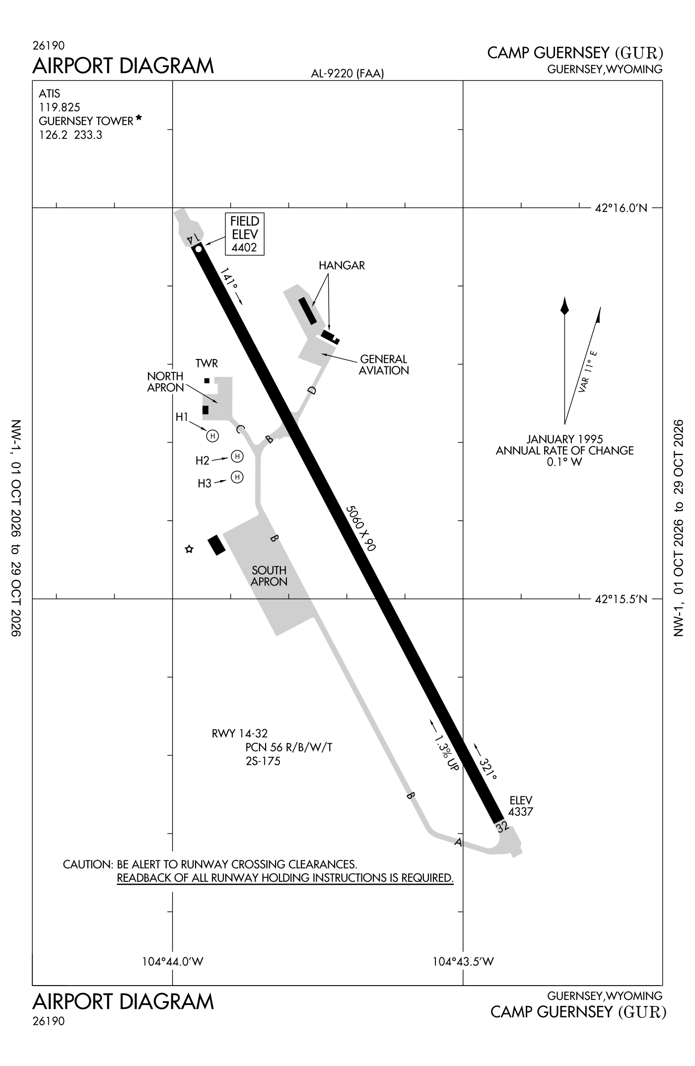
For understanding the field, not for navigation.
| Runway | Length × width | Surface | Lights |
|---|---|---|---|
| 14/32 | 5,060 × 90 ft | Asphalt, fair | Medium-intensity lights |
| H1 | 80 × 80 ft | Concrete, good | |
| H2 | 80 × 80 ft | Concrete, good | |
| H3 | 80 × 80 ft | Concrete, good |
- Runway 14: PAPI, four lights on the left
- Runway 32: PAPI, four lights on the left, right-hand traffic pattern
Radio frequencies
| Common traffic advisory (CTAF) · Tower | 126.2 | Guernsey |
| ATIS (recorded airport information) | 119.825 | Guernsey |
| Operations Cowboy rdo, R-7001/R-7002 | 122.7 | Guernsey · Required call to Guernsey the control tower prior to entering R-7001/R-7002. |
| Lusk and center (remote transmitter) Low/high | 135.6 | Guernsey |
Wind map live wind over the area, from Windy.com
Colours show wind speed, the moving lines its direction; drag the time bar for the coming days. Map and forecast by Windy.com.
Aircraft registered in Guernsey from the FAA register
3 aircraft are registered to owners in Guernsey, Wyoming: 2 drones, 1 piston single. Not every one of them is based at this airport; the based-aircraft count above is the FAA's figure for this airport alone.
Individuals are counted, never named. All aircraft registered in Wyoming.
Accidents and incidents at or near this airport NTSB records
No NTSB accident or incident records name this airport.
Nearby within 30 nautical miles
The FAA's remarks as written in the airport file
- Established prior to 1959.
- City has lease agreement with military for public use.
- Cfr available only on apvd prior permission required at eta/etd.
- Activate PAPI runway 14 and 32; medium-intensity runway lights runway 14/32 - the common traffic frequency.
- Except holidays.
- 2S-175 single tandem wheel rating.
- Runway 14/32 10 feet asphalt NON-WEIGHT bearing shoulders.
- Restricted: extv military R/west and C-130/C17 F/west operates YR round. Aircraft weighing more than 12,500 pounds must use concrete turn arounds at each thld int. All C130/C17 aircraft prior permission required.
- Restricted: north apn restricted to rotor wing/fixed wing UH-60/C-12 or smaller aircraft.
- Traffic pattern: F/west 5900 feet R/west 5100 feet, left traffic runway 14, right traffic runway 32.
- Misc small arms range within 3NM radius of gur, SFC-4000 feet above ground level. R7001 a, B, C, D and R7002 a, B, C 6NM northwest, aircrews must obtain apvl from Guernsey tower prior to entering R7001 and R7002 when active.
- Arng: no tran military maintenance available.
Facts from the FAA's airport file effective October 1, 2026, written out in plain English; weather from the National Weather Service's aviation weather service; registered aircraft from the FAA register as of October 5, 2026; accidents from the NTSB's public database. Owners are shown only when they are an organisation; no person is named. Check the official sources before a flight: this page is for understanding an airport, not for planning one.