
Dallas Love Field to Phoenix Sky Harbor International DAL → PHX
762 nautical miles (877 statute miles) west on a straight line, true course 277°, about 274° magnetic at the departure end (variation 3E). At 120 knots that is 6 h 48 min at the quickest height in today's winds (4,500 ft, a 8-knot headwind), arriving about 7:41 am MST (14:41 UTC). For planning, not a briefing: the legal preflight briefing comes from Flight Service (1-800-WX-BRIEF) or the FAA's own tools. Airlines fly this pair: 5,686 flights in the DOT's last twelve reported months, the route's page.
The route the straight line, the warnings crossed, restrictions, pilot reports and the airports along the way · click a mark for its words
Green, blue, red and purple airport dots are the flying conditions reported there now (VFR, marginal VFR, IFR, low IFR); grey means no report. Red areas are SIGMETs, orange areas AIRMETs, hatched red areas temporary flight restrictions. Map tiles: OpenFreeMap, data © OpenStreetMap contributors.
Warnings the route crosses SIGMETs and AIRMETs whose area the line passes through or comes within 25 nm of
- AIRMET TANGO 1W: moderate turbulence above 18,000 ft (due to mountain wave) from 34,000 ft to 45,000 ft. Over the route from 406 to 653 nm out.
- AIRMET TANGO 2W: moderate turbulence below 18,000 ft (due to mountain wave) up to 22,000 ft. Over the route from 505 to 614 nm out.
- AIRMET TANGO 3W: low-level wind shear (due to air speed loss or gain of 20 knots or more below 2,000 ft above the ground). Over the route from 525 to 604 nm out.
- AIRMET SIERRA 1E: mountains obscured by cloud (due to mountains obscured by clouds, precipitation, mist). Over the route from 634 to 663 nm out.
Turbulence AIRMET in force: moderate turbulence (due to mountain wave) from 34,000 ft to 45,000 ft, over the route from 406 to 653 nm out; AIRMET in force: moderate turbulence (due to mountain wave) up to 22,000 ft, over the route from 505 to 614 nm out. AIRMET in force: low-level wind shear (due to air speed loss or gain of 20 knots or more below 2,000 ft above the ground), over the route from 525 to 604 nm out. No pilot has reported turbulence near the line in the last three hours. The government's turbulence forecast map ↗
Icing No icing warning in force along the route. No pilot has reported icing near the line in the last three hours. The freezing level is about 15,000 ft (from the winds-aloft temperatures), so icing is possible in cloud above that. The government's icing forecast map ↗
A SIGMET warns of weather hazardous to all aircraft; an AIRMET of weather that matters to small aircraft and to flying without instruments. "From 60 to 180 nm out" is measured along the route from DAL.
Pilot reports along the route within 50 nm of the line, last three hours, the serious ones first
Not fetched just now.
Winds aloft along the route, and the time en route the forecast for use 02:00–09:00 UTC · at 120 knots true airspeed
The westbound cruising heights for this course (VFR: even thousands plus 500 ft; above 18,000 ft the forecast levels), with the wind averaged along the line from the 8 forecast points nearest it (DAL, SPS, ABI, LBB, ROW, ABQ, TUS, PHX). A plus sign is a headwind, a minus sign a tailwind.
| Height | Average wind | Head- or tailwind | Temperature | Ground speed | Time en route | Arrival |
|---|---|---|---|---|---|---|
| 4,500 ft | 210° at 20 kt | +8 kt | 18 °C | 112 kt | 6 h 48 min | 7:41 am MST (14:41 UTC) |
| 6,500 ft | 210° at 20 kt | +9 kt | 16 °C | 111 kt | 6 h 52 min | 7:45 am MST (14:45 UTC) |
| 8,500 ft | 210° at 23 kt | +10 kt | 13 °C | 110 kt | 6 h 56 min | 7:49 am MST (14:49 UTC) |
| 10,500 ft | 210° at 24 kt | +12 kt | 9 °C | 108 kt | 7 h 03 min | 7:56 am MST (14:56 UTC) |
| 12,500 ft | 220° at 27 kt | +16 kt | 5 °C | 104 kt | 7 h 20 min | 8:13 am MST (15:13 UTC) |
| 14,500 ft | 220° at 31 kt | +20 kt | 1 °C | 100 kt | 7 h 37 min | 8:30 am MST (15:30 UTC) |
| 16,500 ft | 220° at 36 kt | +24 kt | -3 °C | 96 kt | 7 h 56 min | 8:49 am MST (15:49 UTC) |
| 18,000 ft FL180 | 230° at 40 kt | +27 kt | -6 °C | 93 kt | 8 h 12 min | 9:05 am MST (16:05 UTC) |
| 24,000 ft FL240 | 230° at 56 kt | +41 kt | -16 °C | 79 kt | 9 h 39 min | 10:32 am MST (17:32 UTC) |
| 30,000 ft FL300 | 220° at 63 kt | +38 kt | -28 °C | 82 kt | 9 h 18 min | 10:11 am MST (17:11 UTC) |
| 34,000 ft FL340 | 220° at 60 kt | +39 kt | -37 °C | 81 kt | 9 h 24 min | 10:17 am MST (17:17 UTC) |
| 39,000 ft FL390 | 220° at 59 kt | +39 kt | -49 °C | 81 kt | 9 h 24 min | 10:17 am MST (17:17 UTC) |
Based on data from the 13th at 00:00 UTC; valid on the 13th at 06:00 UTC for use 02:00 to 09:00 UTC; temperatures above 24,000 ft are below zero. Heights are above sea level; a height is left out when the forecast has no wind for it over most of the line (the ground is higher). Ground speed is the airspeed less the headwind; the time en route is for the straight line and ignores climb, descent and routing around weather.
The forecast points as issued
| Point | From | 3,000 | 6,000 | 9,000 | 12,000 | 18,000 | 24,000 | 30,000 | 34,000 | 39,000 |
|---|---|---|---|---|---|---|---|---|---|---|
| DAL | used from 0 nm out; 25 nm from the line | 190/28 | 210/25 18° | 210/20 15° | 230/18 9° | L/V -5° | 260/18 -14° | 260/27 -28° | 250/17 -38° | 250/11 -49° |
| SPS | used from 50 nm out; 61 nm from the line | 200/38 | 210/22 19° | 220/14 16° | 230/14 10° | 250/21 -6° | 250/37 -15° | 240/39 -28° | 240/36 -37° | 250/30 -50° |
| ABI | used from 99 nm out; 44 nm from the line | 210/28 19° | 230/17 17° | 240/11 10° | 240/13 -5° | 240/30 -14° | 220/28 -27° | 220/22 -37° | 250/21 -50° | |
| LBB | used from 198 nm out; 39 nm from the line | 200/24 21° | 220/20 15° | 250/26 8° | 230/33 -5° | 230/52 -15° | 220/47 -27° | 230/41 -37° | 230/42 -50° | |
| ROW | used from 297 nm out; 66 nm from the line | 210/15 | 200/23 14° | 200/30 6° | 230/39 -6° | 230/61 -15° | 210/59 -27° | 220/55 -37° | 220/55 -50° | |
| ABQ | used from 495 nm out; 100 nm from the line | 210/27 11° | 210/32 3° | 220/65 -7° | 230/76 -20° | 220/96 -28° | 220/89 -37° | 220/87 -49° | ||
| TUS | used from 594 nm out; 121 nm from the line | 220/16 14° | 210/26 7° | 220/32 1° | 220/66 -7° | 220/77 -19° | 220/96 -28° | 220/95 -37° | 220/94 -48° | |
| PHX | used from 693 nm out; 45 nm from the line | L/V | 210/19 10° | 200/36 5° | 210/40 0° | 220/59 -9° | 220/68 -20° | 220/102 -30° | 220/119 -37° | 220/117 -48° |
The weather now: both ends and the airports along the way public airports with a weather report within 25 nm of the line, one for each stretch
| Airport | Where | Conditions | Wind | Visibility | Ceiling | Elevation | Reported |
|---|---|---|---|---|---|---|---|
| DAL Dallas, TX | departure | no report just now | 486 ft | ||||
| FTW Fort Worth, TX | 30 nm out, 6 nm southeast of the line, tower | no report just now | 710 ft | ||||
| RPH Graham, TX | 89 nm out, 7 nm northeast of the line | no report just now | 1,122 ft | ||||
| BFE Brownfield, TX | 267 nm out, 6 nm southwest of the line | no report just now | 3,264 ft | ||||
| ROW Roswell, NM | 386 nm out, 5 nm south of the line, tower | no report just now | 3,671 ft | ||||
| TCS Truth Or Consequences, NM | 525 nm out, 13 nm south of the line | no report just now | 4,861 ft | ||||
| IWA Phoenix, AZ | 743 nm out, 8 nm south of the line, tower | no report just now | 1,384 ft | ||||
| PHX Phoenix, AZ | destination | no report just now | 1,134 ft |
The highest airport on this list sits at 4,861 ft; the ground between airports is higher still. Check the sectional chart for the terrain and the minimum safe heights along the line.
The codes as issued, and in English, for every airport in the table
At PHX when you get there the forecast at the estimated arrival, 7:41 am MST (14:41 UTC)
PHX has no terminal forecast; use the nearest airport that does.
Temporary flight restrictions on the line or within 25 nm of it
- 9/2934 DALLAS, TX 2 nm from the route, at the departure end · a VIP movement · ZFW
- 6/8646 Arlington, TX, Thursday, October 15, 2026 through Friday, October 16, 2026 UTC 6 nm from the route, at the departure end · drones kept away from a public gathering · starts Thursday 15 October · ZFW
- 6/8722 ALAMOGORDO, NM, Tuesday, October 13, 2026 Local on the route, 446 nm along the route · security · today · ZAB
Notices to air missions closures and things out of service at both ends; airspace, navigation aids and obstructions near the line
DAL: 27 notices in force, 1 starting within a week. runway 13L/31R closed all of them, grouped →
- closed Runway 13L/31R closed until Tue 13 Oct, 6:00 am CDT (11:00 UTC) · DAL 10/067
as issued
!DAL 10/067 DAL RWY 13L/31R CLSD 2610130400-2610131100
PHX: 44 notices in force, 5 starting within a week. all of them, grouped →
- closed Taxiway T between taxiway C and taxiway D closed to aircraft wingspan more than 171 ft until Fri 30 Oct, 7:00 am MST (14:00 UTC) · PHX 10/005
as issued
!PHX 10/005 PHX TWY T BTN TWY C AND TWY D CLSD TO ACFT WINGSPAN MORE THAN 171FT 2610051300-2610301400
- closed Apron west Cargo APN east 600 ft closed until Thu 31 Dec, 11:59 pm MST (06:59 UTC) · PHX 07/057
as issued
!PHX 07/057 PHX APRON WEST CARGO APN E 600FT CLSD 2607151300-2701010659
- closed Taxiway F8 closed to aircraft exiting runway 07L/25R until Thu 31 Dec, 11:59 pm MST (06:59 UTC) · PHX 12/101
as issued
!PHX 12/101 PHX TWY F8 CLSD TO ACFT EXITING RWY 07L/25R 2601010700-2701010659
Airports along the way: IWA runway 12R closed runway 12R/30L closed runway 30L closed
85 notices near the line, the first 30 (airspace and special activity within 25 nm, navigation aids within 25 nm, obstructions within 5 nm):
- Obstruction tower lights (ASR 1051627) 32°48′N 96°41′W (5.0 nautical miles south T57) 797.9FT (252.0FT above ground level) out of service until Mon 19 Oct, 5:29 am CDT (10:29 UTC) · 0 nm along the route, 9 nm off the line · T57 09/111
as issued
!FTW 09/111 T57 OBST TOWER LGT (ASR 1051627) 324813.00N0964122.00W (5.0NM S T57) 797.9FT (252.0FT AGL) U/S 2609041030-2610191029
- Navigation aid ILS runway 34 DME out of service until Sun 28 Feb, 5:59 pm CST (23:59 UTC), estimated · 0 nm along the route, 8 nm off the line · ADS 08/020
as issued
!ADS 08/020 ADS NAV ILS RWY 34 DME U/S 2608310244-2702282359EST
- Navigation aid ILS runway 16 DME out of service until Sun 28 Feb, 5:59 pm CST (23:59 UTC), estimated · 0 nm along the route, 8 nm off the line · ADS 08/019
as issued
!ADS 08/019 ADS NAV ILS RWY 16 DME U/S 2608310243-2702282359EST
- Obstruction tower lights (ASR 1047720) 32°48′N 97°06′W (6.2 nautical miles SSW DFW) 732.9FT (216.9FT above ground level) out of service until Sat 6 Feb, 12:14 am CST (06:14 UTC) · 10 nm along the route, 4 nm off the line · DFW 10/180
as issued
!DFW 10/180 DFW OBST TOWER LGT (ASR 1047720) 324836.00N0970606.70W (6.2NM SSW DFW) 732.9FT (216.9FT AGL) U/S 2610090614-2702060614
- Obstruction tower lights (ASR 1026540) 32°48′N 97°07′W (7.1 nautical miles southwest DFW) 1022.0FT (499.0FT above ground level) out of service until Sun 24 Jan, 10:38 pm CST (04:38 UTC) · 10 nm along the route, 5 nm off the line · DFW 09/478
as issued
!DFW 09/478 DFW OBST TOWER LGT (ASR 1026540) 324830.00N0970750.50W (7.1NM SW DFW) 1022.0FT (499.0FT AGL) U/S 2609270438-2701250438
- Navigation aid ILS runway 36R out of service until Fri 30 Apr, 6:59 pm CDT (23:59 UTC) · 10 nm along the route, 2 nm off the line · DFW 05/406
as issued
!DFW 05/406 DFW NAV ILS RWY 36R U/S 2605142300-2704302359
- Navigation aid ILS runway 18L out of service until Fri 30 Apr, 6:59 pm CDT (23:59 UTC) · 10 nm along the route, 2 nm off the line · DFW 05/408
as issued
!DFW 05/408 DFW NAV ILS RWY 18L U/S 2605142300-2704302359
- Navigation aid ILS runway 35R inner marker out of service until Sun 28 Nov 2027, 3:11 pm CST (21:11 UTC), estimated · 10 nm along the route, 2 nm off the line · DFW 04/233
as issued
!DFW 04/233 DFW NAV ILS RWY 35R IM U/S 2604081219-2711282111EST
- Navigation aid ILS runway 17L inner marker out of service until Sun 28 Nov 2027, 3:11 pm CST (21:11 UTC), estimated · 10 nm along the route, 2 nm off the line · DFW 04/232
as issued
!DFW 04/232 DFW NAV ILS RWY 17L IM U/S 2604081217-2711282111EST
- Navigation aid ILS runway 35C inner marker out of service until Sun 28 Mar, 4:11 pm CDT (21:11 UTC), estimated · 10 nm along the route, 2 nm off the line · DFW 04/228
as issued
!DFW 04/228 DFW NAV ILS RWY 35C IM U/S 2604081144-2703282111EST
- Navigation aid ILS runway 17C inner marker out of service until Mon 6 Dec 2027, 3:11 pm CST (21:11 UTC), estimated · 10 nm along the route, 2 nm off the line · DFW 04/159
as issued
!DFW 04/159 DFW NAV ILS RWY 17C IM U/S 2604061145-2712062111EST
- Navigation aid ILS runway 18R inner marker out of service until Sat 7 Aug, 1:23 pm CDT (18:23 UTC), estimated · 10 nm along the route, 2 nm off the line · DFW 08/559
as issued
!DFW 08/559 DFW NAV ILS RWY 18R IM U/S 2508211434-2708071823EST
- Navigation aid ILS runway 16L category III not authorized until Sat 31 Oct, 12:00 am CDT (05:00 UTC) · 20 nm along the route, 8 nm off the line · AFW 10/018
as issued
!AFW 10/018 AFW NAV ILS RWY 16L CAT III NA 2610130121-2610310500
- Obstruction tower lights (ASR 1001800) 32°43′N 97°13′W (7.3 nautical miles WNW GKY) 1038.1FT (459.0FT above ground level) out of service until Fri 15 Jan, 8:13 pm CST (02:13 UTC) · 20 nm along the route, 10 nm off the line · GKY 09/012
as issued
!GKY 09/012 GKY OBST TOWER LGT (ASR 1001800) 324306.80N0971324.80W (7.3NM WNW GKY) 1038.1FT (459.0FT AGL) U/S 2609220125-2701160213
- Navigation aid ILS runway 18L outer marker out of service until Tue 7 Dec 2027, 3:11 pm CST (21:11 UTC), estimated · 20 nm along the route, 19 nm off the line · DTO 04/018
as issued
!DTO 04/018 DTO NAV ILS RWY 18L OM U/S 2604171449-2712072111EST
- Navigation aid ILS runway 36L outer marker out of service until Mon 19 Apr, 4:11 pm CDT (21:11 UTC), estimated · 20 nm along the route, 19 nm off the line · FWS 02/005
as issued
!FWS 02/005 FWS NAV ILS RWY 36L OM U/S 2602271517-2704192111EST
- Obstruction tower lights (ASR 1213187) 32°48′N 97°21′W (0.8 nautical miles southeast FTW) 797.2FT (160.1FT above ground level) out of service until Thu 31 Dec, 4:35 am CST (10:35 UTC) · 30 nm along the route, 7 nm off the line · FTW 10/151
as issued
!FTW 10/151 FTW OBST TOWER LGT (ASR 1213187) 324836.10N0972103.00W (0.8NM SE FTW) 797.2FT (160.1FT AGL) U/S 2610020935-2612311035
- Navigation aid ILS runway 16 outer marker out of service until Wed 28 Oct, 6:59 pm CDT (23:59 UTC) · 30 nm along the route, 6 nm off the line · FTW 07/859
as issued
!FTW 07/859 FTW NAV ILS RWY 16 OM U/S 2607282127-2610282359
- Navigation aid VOR/DME approach control not authorized MQP VORTAC out of service until Sat 24 Apr, 6:59 pm CDT (23:59 UTC) · 40 nm along the route, 11 nm off the line · WEA 04/682
as issued
!FTW 04/682 WEA NAV VOR/DME APP NOT AUTHORIZED MQP VORTAC U/S 2504241739-2704242359
- Obstruction tower lights (ASR 1331259) 32°54′N 97°54′W (11 nautical miles northeast MWL) 1,471 ft (311 ft above ground level) out of service until Thu 19 Nov, 3:16 pm CST (21:16 UTC), estimated · 50 nm along the route, 4 nm off the line · MWL 10/002
as issued
!MWL 10/002 MWL OBST TOWER LGT (ASR 1331259) 325436.10N0975419.70W (11NM NE MWL) 1471FT (311FT AGL) U/S 2610051517-2611192116EST
- Navigation aid VORTAC out of service until Fri 27 Nov, 2:00 pm CST (20:00 UTC), estimated · 59 nm along the route, 14 nm off the line · MQP 02/774
as issued
!FTW 02/774 MQP NAV VORTAC U/S 2602270219-2611272000EST
- Obstruction tower lights (ASR 1267831) 32°55′N 98°17′W (7.3 nautical miles east F35) 1323.8FT (319.9FT above ground level) out of service until Tue 27 Oct, 6:59 pm CDT (23:59 UTC) · 69 nm along the route, 5 nm off the line · F35 08/661
as issued
!FTW 08/661 F35 OBST TOWER LGT (ASR 1267831) 325533.60N0981731.50W (7.3NM E F35) 1323.8FT (319.9FT AGL) U/S 2608271546-2610272359
- Obstruction tower lights (ASR 1233443) 33°02′N 98°30′W (4.3 nautical miles SSE RPH) 1784.8FT (465.9FT above ground level) out of service until Thu 19 Nov, 5:59 pm CST (23:59 UTC) · 89 nm along the route, 5 nm off the line · RPH 08/013
as issued
!RPH 08/013 RPH OBST TOWER LGT (ASR 1233443) 330247.00N0983052.10W (4.3NM SSE RPH) 1784.8FT (465.9FT AGL) U/S 2608290020-2611192359
- Obstruction tower lights (ASR 1052445) 33°07′N 98°35′W (1.7 nautical miles WNW RPH) 1319.2FT (219.2FT above ground level) out of service until Wed 11 Nov, 5:59 pm CST (23:59 UTC) · 89 nm along the route, 7 nm off the line · RPH 08/001
as issued
!RPH 08/001 RPH OBST TOWER LGT (ASR 1052445) 330710.00N0983513.00W (1.7NM WNW RPH) 1319.2FT (219.2FT AGL) U/S 2608111723-2611112359
- Obstruction tower lights (ASR 1055235) 33°03′N 98°53′W (14.8 nautical miles southeast 72F) 1,498 ft (237 ft above ground level) out of service until Thu 19 Nov, 3:22 pm CST (21:22 UTC), estimated · 99 nm along the route, 5 nm off the line · 72F 10/239
as issued
!FTW 10/239 72F OBST TOWER LGT (ASR 1055235) 330311.40N0985354.20W (14.8NM SE 72F) 1498FT (237FT AGL) U/S 2610051522-2611192122EST
- Obstruction tower lights (ASR 1207765) 33°09′N 99°48′W (5.3 nautical miles WSW 15F) 2163.1FT (512.1FT above ground level) out of service until Fri 16 Oct, 11:00 am CDT (16:00 UTC) · 149 nm along the route, 4 nm off the line · 15F 09/765
as issued
!FTW 09/765 15F OBST TOWER LGT (ASR 1207765) 330940.30N0994858.30W (5.3NM WSW 15F) 2163.1FT (512.1FT AGL) U/S 2609251559-2610161600
- Obstruction wind Turbine lights (ASN 2019-WTW-5169-OE) 33°03′N 100°29′W (10.7 nautical miles SSE 22F) 2,572 ft (499 ft above ground level) out of service until Fri 11 Dec, 5:59 pm CST (23:59 UTC) · 188 nm along the route, 7 nm off the line · 22F 10/269
as issued
!FTW 10/269 22F OBST WIND TURBINE LGT (ASN 2019-WTW-5169-OE) 330333N1002956W (10.7NM SSE 22F) 2572FT (499FT AGL) U/S 2610070114-2612112359
- Obstruction tower lights (ASR 1232943) 33°11′N 101°23′W (3.1 nautical miles west 5F1) 2894.0FT (235.9FT above ground level) out of service until Thu 15 Oct, 12:45 am CDT (05:45 UTC) · 228 nm along the route, 3 nm off the line · 5F1 09/994
as issued
!FTW 09/994 5F1 OBST TOWER LGT (ASR 1232943) 331135.90N1012355.70W (3.1NM W 5F1) 2894.0FT (235.9FT AGL) U/S 2609300645-2610150545
- Navigation aid ILS runway 21 glide path out of service until Wed 21 Oct, 6:00 pm CDT (23:00 UTC) · 386 nm along the route, 5 nm off the line · ROW 10/002
as issued
!ROW 10/002 ROW NAV ILS RWY 21 GP U/S 2610061317-2610212300
- Navigation aid VOR ground receive Checkpoint out of service until Mon 5 Apr, 4:11 pm CDT (21:11 UTC), estimated · 386 nm along the route, 5 nm off the line · ROW 10/001
as issued
!ROW 10/001 ROW NAV VOR GND REC CHECKPOINT U/S 2610051219-2704052111EST
From the FAA's notice service (NOTAMs), the site's copy refreshed every few minutes; last checked 2 minutes ago. The FAA has so far issued eFlight its test feed, which misses some notices (checked against the FAA's own search on 12 October: about a third missing at Santa Barbara and Burbank, none at Atlanta or Las Vegas); the request for the full feed is with the FAA. Times are local to the field. This is for planning; the legal briefing comes from Flight Service or the FAA's own tools.
Daylight
Sunset at DAL 6:56 pm CDT (23:56 UTC), at PHX 5:55 pm MST (00:55 UTC) (civil twilight ends 6:20 pm MST (01:20 UTC)).
Each restriction opens the FAA's own page with the exact area, heights and times.
The wind over the route live wind map, from Windy.com · drag the time bar for the coming hours; the level menu changes the height
Colours show wind speed, the moving lines its direction, at the surface unless you pick a height. Map and forecast by Windy.com; a second opinion beside the government's winds-aloft table above.
Radar and forecast charts for the regions crossed government pictures, the latest each time the page loads · the turbulence and icing forecasts: turbulence ↗ · icing ↗
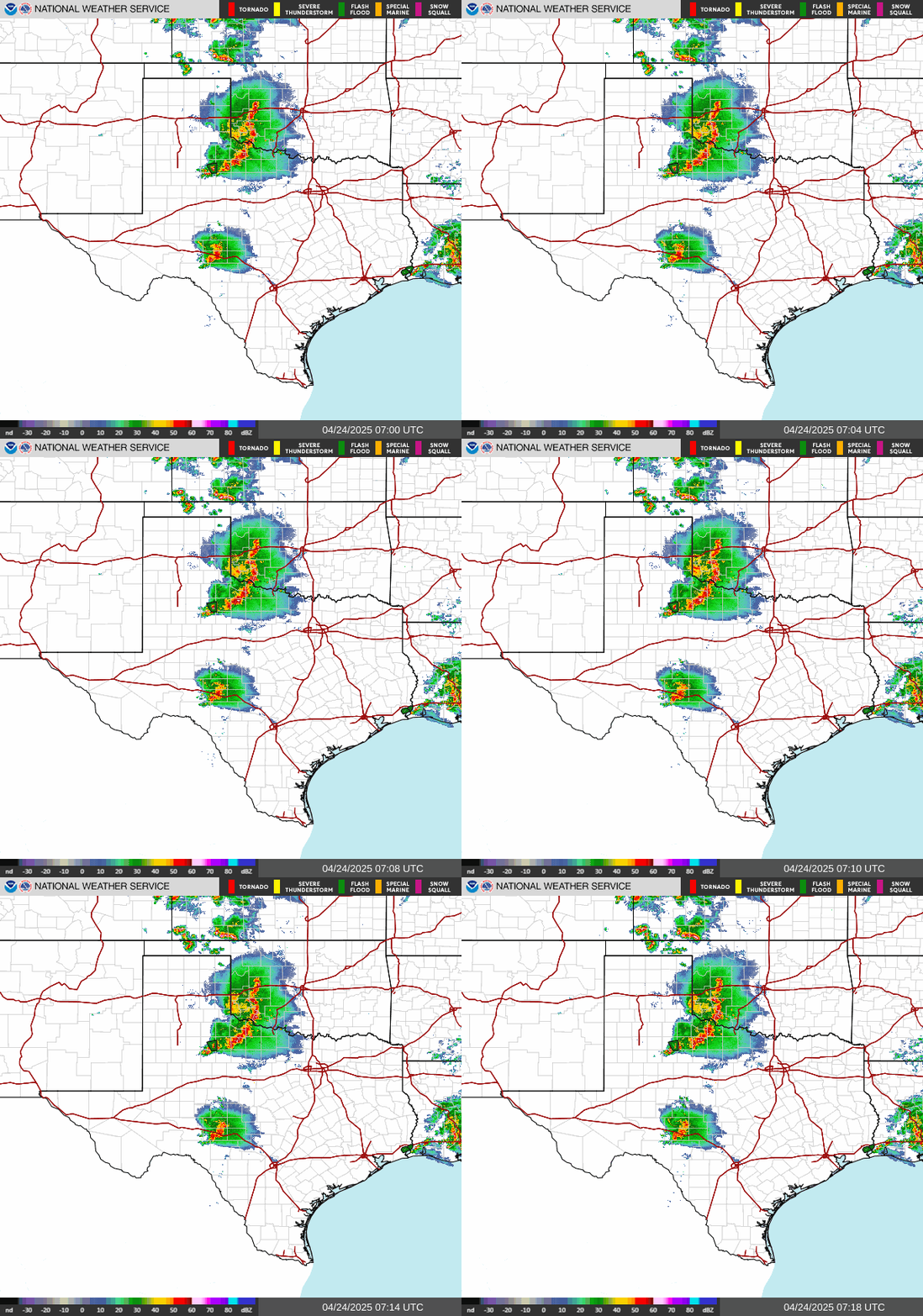



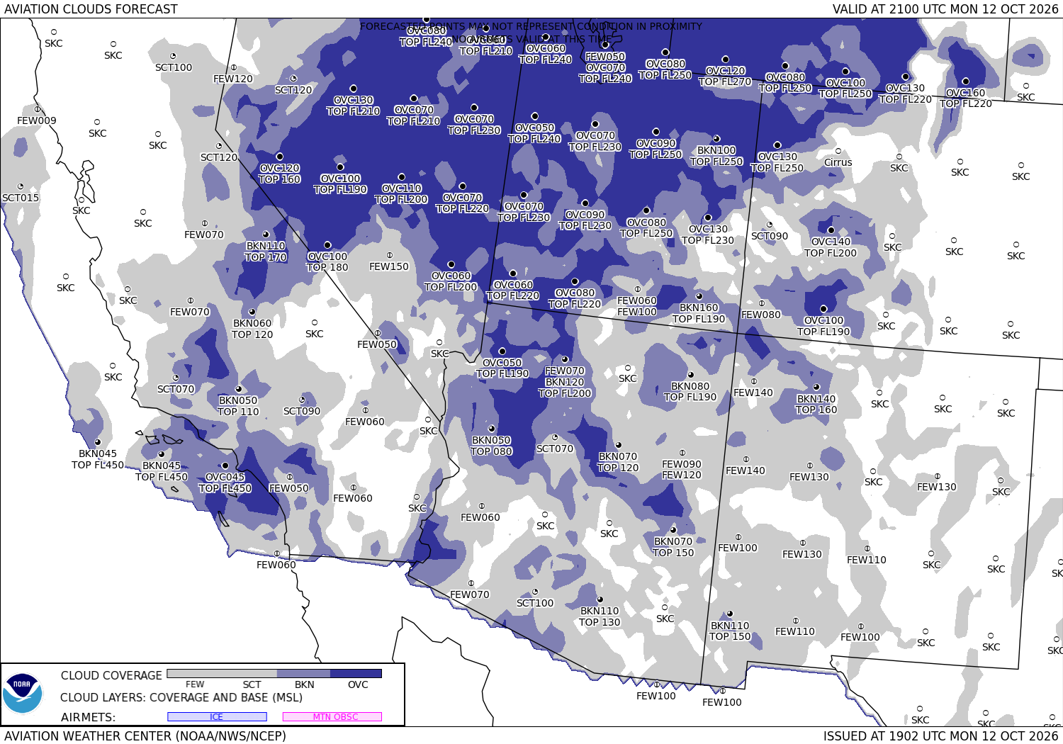
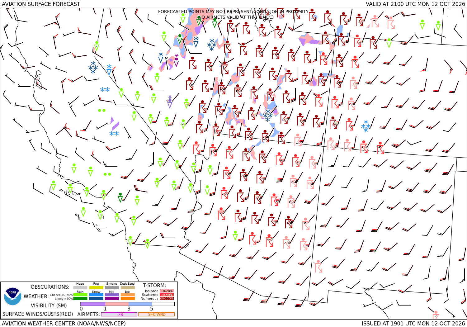




Sources: the Aviation Weather Center's data service (SIGMETs, AIRMETs, graphical AIRMETs, pilot reports, winds and temperatures aloft, observations and terminal forecasts), the National Weather Service radar, the Weather Prediction Center's charts, the FAA's temporary flight restriction list and shapes, and the FAA's airport file for the positions, elevations and magnetic variation. Fetched when the page is viewed and kept a few minutes. Each leg is the straight line between its two airports; airways, terrain and airspace are not considered. The airports in detail: Dallas Love Field, Phoenix Sky Harbor International.