
Travis Air Force Base
SUU · KSUU · Fairfield, California · Solano County · map
Travis Air Force Base is a private airport owned by Usaf, 3 miles east of Fairfield, California, 63 feet above sea level. It has 3 runways; the longest, 03L/21R, is 11,001 feet of partially concrete. It has a control tower and fuel (Jet A with additives).
Private use: permission from the owner is required before landing here.
Weather right now KSUU · observed 3:55 pm PDT (22:55 UTC), 37 minutes ago
VFR good flying weather
- Wind from the south-southwest (200°) at 12 knots
- Visibility 10 miles or more
- Temperature 74°F (24°C), dew point 45°F (7°C)
- Altimeter 29.55 inHg
The forecast issued Sun 11:55 am PDT (18:55 UTC), good until Mon 6:00 pm PDT (01:00 UTC)
- From Sun 12:00 pm PDT (19:00 UTC): wind from the southwest at 12 knots, clear skies
- Changing between Mon 3:00 am PDT (10:00 UTC) and 5:00 am PDT (12:00 UTC) to: wind light and variable, clear skies
The codes as issued (METAR and TAF)
METAR KSUU 112255Z AUTO 20012KT 10SM CLR 24/07 A2955 RMK AO2 SLP013 T02350071 $
TAF KSUU 111855Z 1119/1301 23012KT 9999 SKC QNH2953INS BECMG 1210/1212 VRB06KT 9999 SKC QNH2981INS TX23/1123Z TN11/1214Z
From the National Weather Service's aviation weather service, refreshed every few minutes; times are local to the airport with UTC in brackets. For a flight, get your briefing from Flight Service or an approved provider.
The airport
- Codes
- FAA SUU · ICAO KSUU
- Kind
- Airport · private use, permission required · owned by the Air Force
- Owner
- Usaf
- Elevation
- 63 feet above sea level
- Control tower
- A control tower with radar approach control · around the clock
- Attended
- around the clock
- Lights
- beacon sunset to sunrise
- Fuel and services
- Jet A with additives; the services card below
- On the chart
- San Francisco sectional
- Magnetic variation
- 13E
- In the FAA's files since
- May 1941
Runways 3
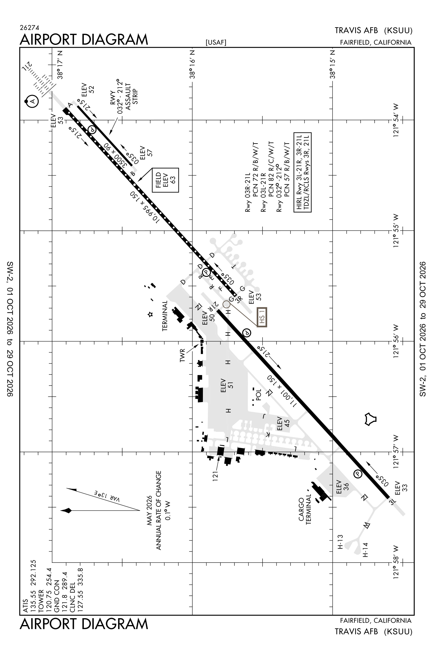
For understanding the field, not for navigation.
| Runway | Length × width | Surface | Lights |
|---|---|---|---|
| 03L/21R | 11,001 × 300 ft | Partially concrete | High-intensity lights |
| 03R/21L | 10,995 × 150 ft | Concrete | High-intensity lights |
| 032/212 | 3,500 × 90 ft | Concrete |
- Runway 03L: localizer and glideslope, PAPI, four lights on the left
- Runway 21R: PAPI, four lights on the left
- Runway 03R: PAPI, four lights on the left
- Runway 21L: ILS, PAPI, four lights on the left, approach lights with sequenced flashers (ALSF-2)
Radio frequencies
| Digital ATIS | 135.55 | Travis |
| Clearance delivery | 127.55 | Travis |
| Ground | 121.8 | Travis |
| Tower | 120.75 | Travis |
| Approach · Bmber and star · Departure South | 119.9 | Travis |
| Approach · Bmber and star · Departure (secondary) North | 126.6 | Travis |
| Approach (secondary) · Approach and departure | 128.4 | Travis |
| Approach (secondary) | 139.9 | Travis |
| Emergency | 121.5 | Travis |
| Palisades and star | 123.7 | Travis |
| Bmber and star | 124.8 | Travis |
| Comd and post | 141.9 | Travis · Comd post vhf frequency unsvc. |
Aircraft registered in Fairfield from the FAA register
47 aircraft are registered to owners in Fairfield, California: 38 piston singles, 5 piston twins, 2 drones, 1 turboprop, 1 weight-shift or powered parachute. Not every one of them is based at this airport; the based-aircraft count above is the FAA's figure for this airport alone.
Companies and organisations in town with two or more aircraft:
Individuals are counted, not named (the site's policy at this time). All aircraft registered in California.
Fuel and services as reported to the FAA
- Fuel
- Jet A with additives
- Repairs
- airframe and engine: major repairs
- Parking
- hangars
- Oxygen
- bulk oxygen (high- and low-pressure)
Nearest fields reporting avgas: Nut Tree Airport (7 nm north), Rio Vista Municipal (11 nm east), Napa County (17 nm west), University Airport (17 nm north).
Other fields with jet fuel nearby: Nut Tree Airport (7 nm north), Napa County (17 nm west), Buchanan Field (18 nm south).
The FAA's file records what is sold and done at the field, as the airport manager reports it, not who sells it or the price; fuel sellers (FBOs) are not named in any public file. Airports selling jet fuel in California · avgas.
Who works here from the FAA's certificate lists and the register
Repair stations in Fairfield:
Companies in the same town as this airport; not every one of them works from this field. All operators · all repair stations · all flight schools · all FBOs.
Accidents and incidents at or near this airport NTSB records · 5 since 1982, 3 fatal
Cases the NTSB recorded with this as the nearest airport, newest first. Each opens the full report in plain English. The country as a whole: Where accidents happen.
Nearby within 30 nautical miles
The FAA's remarks as written in the airport file, spelled out
- RWY-LGTS: runway 21L SF.
- Jasu - 1(MA-1) 6(MA-1A) 1(MC-1A) 1(MC-2A) 8(A/M32A-86) 1(707 starting unit).
- Oil - O-128-133-148-156.
- Remarks: hvy concentration of blackbirds, gulls, and otr migratory birds in the approach and departure rtes and alg infield areas from 1 OCT-30 nov and from 1 FEB-30 apr (phase II).
- Caution: runway edge lights for both runways located more than 10 feet from edge of usable runway surface.
- Caution: extv light aircraft operates. Possible RF intfc all frequencies 9 NM northeast over voa transient. Exp wind shear below 2000 feet on approach to all runways. Hvy C5 jet traffic in immed vicinity. HI density VFR traffic cros final approach and departure crs.
- Caution: arrival aircraft exp hvy jet aircraft cros runway to parl taxiway.
- Misc: first 2175 feet runway 03R and first 1000 feet runway 21L concrete; 75 feet keel section is concrete, rmng width is reinforced asphalt, 38 feet on either side of keel. First 1000 feet runway 21R and first 2900 feet runway 03L concrete, mid 7100 feet asphalt.
- Traffic pattern revise to: rectangular 1600 feet, overhead 2100 feet.
- Caution: taxiway north may be tmpry closed WO ntc south of 900 ramp due to C17 combat OFF-LOAD/STAR training.
- Restricted: outboard engs of 4-ENG aircraft rstrd to idle pwr on taxiways a, B, D, H, M, north, and T and drg taxi operations on runway 03R/21L.
- Caution: no C17 combat offloads authorized on taxiway delta east of runway 21L/3R.
Connections how this airport links to the rest of the register
- Aircraft registered in Fairfield 47 aircraft · 38 piston singles, 5 piston twins, 2 drones
- Solano County Mad 2 aircraft in town
- North Bay Aviation · repair station
- NTSB accidents and incidents at or near this airport 5 since 1982 · 3 fatal
- Accidents and incidents in California 9,069 since 1982 · 1,094 in the last ten years
- Nearby landing places within 30 nautical miles 8 airports, heliports and seaplane bases
- Public-use airports in California 244 landing places
- California 27,552 aircraft registered
The whole map of how records connect · these connections as data: /graph/airport/SUU.json.
Facts from the FAA's airport file effective October 1, 2026, written out in plain English; weather from the National Weather Service's aviation weather service; registered aircraft from the FAA register as of October 9, 2026; accidents from the NTSB's public database. Owners are shown only when they are an organisation; no person is named. Check the official sources before a flight: this page is for understanding an airport, not for planning one.