
Wright-Patterson Air Force Base
FFO · KFFO · Dayton, Ohio · Greene County · map
Wright-Patterson Air Force Base is a private airport owned by the US Air Force, 8 miles northeast of Dayton, Ohio, 823 feet above sea level. It has 2 runways; the longest, 05L/23R, is 12,600 feet of partially concrete. It has a control tower.
Private use: permission from the owner is required before landing here.
Weather right now KFFO · observed 6:55 pm EDT (22:55 UTC), 74 minutes ago
IFR instrument conditions
- Wind from the west-northwest (300°) at 5 knots
- Visibility 7 miles
- Sky: overcast at 800 feet
- Temperature 63°F (17°C), dew point 60°F (16°C)
- Altimeter 29.92 inHg
The forecast issued Sun 5:55 pm EDT (21:55 UTC), good until Mon 9:00 pm EDT (01:00 UTC)
- From Sun 5:00 pm EDT (21:00 UTC): wind from the north-northwest at 9 knots, overcast at 900 feet IFR
- Changing between Sun 7:00 pm EDT (23:00 UTC) and 9:00 pm EDT (01:00 UTC) to: wind from the north-northwest at 9 knots, overcast at 1,500 feet MVFR
- Changing between Mon 1:00 am EDT (05:00 UTC) and 2:00 am EDT (06:00 UTC) to: wind from the west-northwest at 6 knots, scattered clouds at 2,000 feet
- Changing between Mon 3:00 am EDT (07:00 UTC) and 5:00 am EDT (09:00 UTC) to: wind from the west at 6 knots, mist, a few clouds at 2,500 feet
- Changing between Mon 5:00 am EDT (09:00 UTC) and 7:00 am EDT (11:00 UTC) to: wind from the west-southwest at 6 knots, fog, overcast at 200 feet LIFR
- Changing between Mon 8:00 am EDT (12:00 UTC) and 10:00 am EDT (14:00 UTC) to: wind from the west-southwest at 9 knots, a few clouds at 4,000 feet
- Changing between Mon 1:00 pm EDT (17:00 UTC) and 3:00 pm EDT (19:00 UTC) to: wind from the south-southwest at 12 knots, a few clouds at 4,000 feet, scattered clouds at 10,000 feet
The codes as issued (METAR and TAF)
METAR KFFO 112255Z 30005KT 7SM OVC008 17/16 A2992 RMK AO2A CIG 007V009 SLP133 WND DATA ESTMD T01700155
TAF AMD KFFO 112155Z 1121/1301 33009KT 9999 OVC009 QNH2990INS BECMG 1123/1201 33009KT 9999 OVC015 QNH2992INS BECMG 1205/1206 30006KT 9999 SCT020 QNH2996INS BECMG 1207/1209 27006KT 3200 BR FEW025 QNH2998INS BECMG 1209/1211 24006KT 0800 FG OVC002 QNH3000INS BECMG 1212/1214 24009KT 9999 NSW FEW040 QNH3001INS BECMG 1217/1219 21012KT 9999 FEW040 SCT100 QNH2990INS TX18/1122Z TN14/1211Z
From the National Weather Service's aviation weather service, refreshed every few minutes; times are local to the airport with UTC in brackets. For a flight, get your briefing from Flight Service or an approved provider.
The airport
- Codes
- FAA FFO · ICAO KFFO
- Kind
- Airport · private use, permission required · owned by the Air Force
- Owner
- US Air Force
- Elevation
- 823 feet above sea level
- Control tower
- A control tower · around the clock
- Attended
- around the clock
- Lights
- beacon sunset to sunrise
- Fuel and services
- no fuel reported; the services card below
- On the chart
- Cincinnati sectional
- Magnetic variation
- 4W
- In the FAA's files since
- August 1943
Runways 2
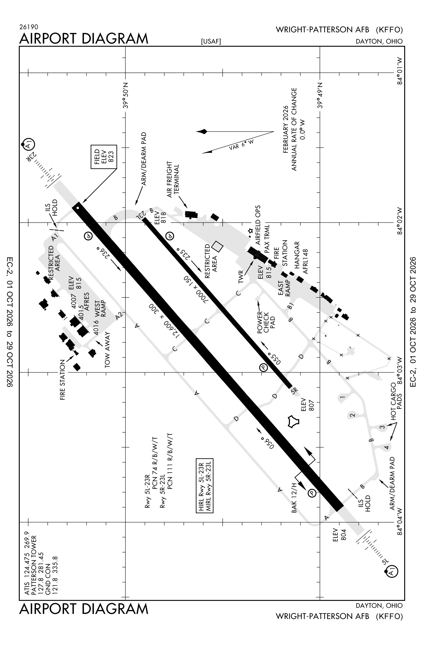
For understanding the field, not for navigation.
| Runway | Length × width | Surface | Lights |
|---|---|---|---|
| 05L/23R | 12,600 × 300 ft | Partially concrete | High-intensity lights |
| 05R/23L | 7,000 × 150 ft | Asphalt | Medium-intensity lights |
- Runway 05L: ILS, PAPI, four lights on the left, approach lights with sequenced flashers (ALSF-1)
- Runway 23R: ILS, PAPI, four lights on the right, approach lights with sequenced flashers (ALSF-1), right-hand traffic pattern
- Runway 05R: PAPI, four lights on the left
- Runway 23L: PAPI, four lights on the left
Radio frequencies
| ATIS (recorded airport information) | 124.475 | Patterson |
| Ground | 121.8 | Patterson |
| Tower | 127.8 | Patterson |
| Tower (secondary) | 115.2 | Patterson |
| Approach and departure | 118.85 | Patterson |
| Emergency | 121.5 | Patterson |
| Pre-taxi clearance | 126.2 | Patterson |
| Danei and star | 134.45 | Patterson |
Aircraft registered in Dayton from the FAA register
146 aircraft are registered to owners in Dayton, Ohio: 102 piston singles, 12 drones, 10 piston twins, 8 business jets, 4 helicopters. Not every one of them is based at this airport; the based-aircraft count above is the FAA's figure for this airport alone.
Companies and organisations in town with two or more aircraft:
Individuals are counted, not named (the site's policy at this time). All aircraft registered in Ohio.
Fuel and services as reported to the FAA
- Fuel
- none reported
- Repairs
- airframe and engine: major repairs
- Parking
- hangars
- Oxygen
- bulk oxygen (high- and low-pressure)
- Also here
- cargo handling
Nearest fields reporting jet fuel: Greene County/Lewis A Jackson Regional (8 nm south), James M Cox Dayton International (9 nm northwest), Springfield/Beckley Municipal (10 nm east), Dayton/Wright Brothers Airport (16 nm southwest).
Nearest fields reporting avgas: Greene County/Lewis A Jackson Regional (8 nm south), James M Cox Dayton International (9 nm northwest), Springfield/Beckley Municipal (10 nm east), Moraine Air Park Airport (12 nm southwest).
The FAA's file records what is sold and done at the field, as the airport manager reports it, not who sells it or the price; fuel sellers (FBOs) are not named in any public file. Airports selling jet fuel in Ohio · avgas.
Who works here from the FAA's certificate lists and the register
Flight schools, flying clubs and college flight programmes in Dayton, by their names on the register:
- Sinclair Community College 8 aircraft Sinclair Community College is a community college in Dayton, Ohio, serving a multi-county region in Southwest Ohio.
Repair stations in Dayton:
- Ge Aviation Systems LLC
- Projects Unlimited INC Projects Unlimited Inc.
- Techmetals INC Techmetals, Inc.
- U.S. Chrome CORP. of Ohio
Companies in the same town as this airport; not every one of them works from this field. All operators · all repair stations · all flight schools · all FBOs.
Accidents and incidents at or near this airport NTSB records · 5 since 1982, 1 fatal
Cases the NTSB recorded with this as the nearest airport, newest first. Each opens the full report in plain English. The country as a whole: Where accidents happen.
Nearby within 30 nautical miles
The FAA's remarks as written in the airport file, spelled out
- Rectangular fighter/tactical/trainer aircraft 2400' above sea level, other turbojet/turboprop and light reciprocating eng aircraft (12,500 LB or below gross weight) 1900', overhead 2400' above sea level.
- Operates H24 except AD closed major holidays and otr times by NOTAM.
- TYPE-H BAK-12B(B) (1676 feet).
- Southwest 2600 feet concrete, northeast 10000 feet asphalt.
- Caution: portions of flameout and overhead traffic pattern not visibility from tower.
- Misc: exp departure FR runway 23R at taxiway 'B' int 11,600 feet available; if full length rqr, RQ BACK-TAXI from tower.
- Caution: unlighted obstruction sur afld.
- Caution: bird watch condition phase I (NOV-JUN) indicates light bird act, phase II (JUL-OCT) indicates hvy bird act nml associated with migratory season.
- Misc: unlighted abandoned tower west side field.
- Misc: amops C937-257-4492, dsn 787-4492.
- Afrc: 445 AW operates 1200--0330Z++. MON-FRI and training wkend.
- Customs/agricultural/img: ltd customs available. U.S. military required a mnm of 24 hour PN, foreign state aircraft a mnm of 48 hour PN, amops C937-257-4492, dsn 787-4492.
Connections how this airport links to the rest of the register
- Aircraft registered in Dayton 146 aircraft · 102 piston singles, 12 drones, 10 piston twins
- Sinclair Community College 8 aircraft in town
- Miami Valley Hospital 2 aircraft in town
- Core Aviation LLC 2 aircraft in town
- Buckeye Aircraft Holdings LLC 2 aircraft in town
- Sinclair Community College 8 aircraft · university or college with a flight programme
- Ge Aviation Systems LLC · repair station
- Projects Unlimited INC · repair station
- Techmetals INC · repair station
- U.S. Chrome CORP. of Ohio · repair station
- NTSB accidents and incidents at or near this airport 5 since 1982 · 1 fatal
- Accidents and incidents in Ohio 1,877 since 1982 · 249 in the last ten years
- Nearby landing places within 30 nautical miles 8 airports, heliports and seaplane bases
- Public-use airports in Ohio 149 landing places
- Ohio 8,518 aircraft registered
The whole map of how records connect · these connections as data: /graph/airport/FFO.json.
Facts from the FAA's airport file effective October 1, 2026, written out in plain English; weather from the National Weather Service's aviation weather service; registered aircraft from the FAA register as of October 9, 2026; accidents from the NTSB's public database. Owners are shown only when they are an organisation; no person is named. Check the official sources before a flight: this page is for understanding an airport, not for planning one.