
Harry Reid International to Montrose Regional LAS → MTJ
376 nautical miles (433 statute miles) northeast on a straight line, true course 065°, about 054° magnetic at the departure end (variation 11E). At 120 knots that is 1 h 52 min at the quickest height in today's winds (34,000 ft, a 82-knot tailwind), arriving about 4:29 am MDT (10:29 UTC), after sunset at the destination. For planning, not a briefing: the legal preflight briefing comes from Flight Service (1-800-WX-BRIEF) or the FAA's own tools. Airlines fly this pair: 1 flights in the DOT's last twelve reported months, the route's page.
The route the straight line, the warnings crossed, restrictions, pilot reports and the airports along the way · click a mark for its words
Green, blue, red and purple airport dots are the flying conditions reported there now (VFR, marginal VFR, IFR, low IFR); grey means no report. Red areas are SIGMETs, orange areas AIRMETs, hatched red areas temporary flight restrictions. Map tiles: OpenFreeMap, data © OpenStreetMap contributors.
Warnings the route crosses SIGMETs and AIRMETs whose area the line passes through or comes within 25 nm of
- AIRMET TANGO 1W: moderate turbulence above 18,000 ft from 18,000 ft to 39,000 ft. Over the first 20 nm of the route.
- AIRMET SIERRA 1E: mountains obscured by cloud (due to mountains obscured by clouds, precipitation, mist). Over the last 297 nm of the route.
- AIRMET TANGO 1W: moderate turbulence above 18,000 ft (due to mountain wave) from 34,000 ft to 45,000 ft. Over the last 267 nm of the route.
- AIRMET TANGO 2W: moderate turbulence below 18,000 ft (due to mountain wave) up to 22,000 ft. Over the last 267 nm of the route.
- AIRMET TANGO 3W: low-level wind shear (due to air speed loss or gain of 20 knots or more below 2,000 ft above the ground). Over the route from 139 to 208 nm out.
- AIRMET ZULU 1C: moderate icing up to 22,000 ft. Over the last 237 nm of the route.
Turbulence AIRMET in force: moderate turbulence from 18,000 ft to 39,000 ft, over the first 20 nm of the route; AIRMET in force: moderate turbulence (due to mountain wave) from 34,000 ft to 45,000 ft, over the last 267 nm of the route. AIRMET in force: low-level wind shear (due to air speed loss or gain of 20 knots or more below 2,000 ft above the ground), over the route from 139 to 208 nm out. No pilot has reported turbulence near the line in the last three hours. The government's turbulence forecast map ↗
Icing AIRMET in force: moderate icing up to 22,000 ft, over the last 237 nm of the route. No pilot has reported icing near the line in the last three hours. The freezing level is about 9,500 ft (from the winds-aloft temperatures), so icing is possible in cloud above that. The government's icing forecast map ↗
A SIGMET warns of weather hazardous to all aircraft; an AIRMET of weather that matters to small aircraft and to flying without instruments. "From 60 to 180 nm out" is measured along the route from LAS.
Pilot reports along the route within 50 nm of the line, last three hours, the serious ones first
Not fetched just now.
Winds aloft along the route, and the time en route the forecast for use 08:00–15:00 UTC · at 120 knots true airspeed
The eastbound cruising heights for this course (VFR: odd thousands plus 500 ft; above 18,000 ft the forecast levels), with the wind averaged along the line from the 3 forecast points nearest it (LAS, BCE, GJT). A plus sign is a headwind, a minus sign a tailwind.
| Height | Average wind | Head- or tailwind | Temperature | Ground speed | Time en route | Arrival |
|---|---|---|---|---|---|---|
| 7,500 ft | 220° at 13 kt | −11 kt | 3 °C | 131 kt | 2 h 52 min | 5:29 am MDT (11:29 UTC) |
| 9,500 ft | 220° at 17 kt | −14 kt | 0 °C | 134 kt | 2 h 48 min | 5:25 am MDT (11:25 UTC) |
| 11,500 ft | 230° at 29 kt | −28 kt | -5 °C | 148 kt | 2 h 32 min | 5:09 am MDT (11:09 UTC) |
| 13,500 ft | 230° at 36 kt | −34 kt | -8 °C | 154 kt | 2 h 26 min | 5:03 am MDT (11:03 UTC) |
| 15,500 ft | 230° at 42 kt | −39 kt | -12 °C | 159 kt | 2 h 22 min | 4:59 am MDT (10:59 UTC) |
| 17,500 ft | 220° at 49 kt | −45 kt | -15 °C | 165 kt | 2 h 17 min | 4:54 am MDT (10:54 UTC) |
| 18,000 ft FL180 | 220° at 50 kt | −46 kt | -16 °C | 166 kt | 2 h 16 min | 4:53 am MDT (10:53 UTC) |
| 24,000 ft FL240 | 230° at 71 kt | −68 kt | -24 °C | 188 kt | 2 h | 4:37 am MDT (10:37 UTC) |
| 30,000 ft FL300 | 230° at 76 kt | −73 kt | -36 °C | 193 kt | 1 h 57 min | 4:34 am MDT (10:34 UTC) |
| 34,000 ft FL340 | 230° at 86 kt | −82 kt | -40 °C | 202 kt | 1 h 52 min | 4:29 am MDT (10:29 UTC) |
| 39,000 ft FL390 | 220° at 88 kt | −81 kt | -45 °C | 201 kt | 1 h 52 min | 4:29 am MDT (10:29 UTC) |
Based on data from the 13th at 06:00 UTC; valid on the 13th at 12:00 UTC for use 08:00 to 15:00 UTC; temperatures above 24,000 ft are below zero. Heights are above sea level; a height is left out when the forecast has no wind for it over most of the line (the ground is higher). Ground speed is the airspeed less the headwind; the time en route is for the straight line and ignores climb, descent and routing around weather.
The forecast points as issued
| Point | From | 3,000 | 6,000 | 9,000 | 12,000 | 18,000 | 24,000 | 30,000 | 34,000 | 39,000 |
|---|---|---|---|---|---|---|---|---|---|---|
| LAS | used from 0 nm out; 25 nm from the line | 270/9 5° | 220/11 -1° | 250/19 -5° | 260/59 -13° | 270/75 -22° | 280/74 -39° | 260/64 -44° | 240/61 -46° | |
| BCE | used from 99 nm out; 57 nm from the line | 240/35 -7° | 210/53 -19° | 220/87 -25° | 220/80 -36° | 230/84 -39° | 220/90 -45° | |||
| GJT | used from 247 nm out; 100 nm from the line | 210/17 3° | 220/37 -4° | 210/53 -16° | 220/64 -24° | 220/96 -35° | 220/114 -38° | 220/110 -45° |
The weather now: both ends and the airports along the way public airports with a weather report within 25 nm of the line, one for each stretch
| Airport | Where | Conditions | Wind | Visibility | Ceiling | Elevation | Reported |
|---|---|---|---|---|---|---|---|
| LAS Las Vegas, NV | departure | no report just now | 2,183 ft | ||||
| AZC Colorado City, AZ | 119 nm out, 6 nm northwest of the line | no report just now | 4,873 ft | ||||
| KNB Kanab, UT | 139 nm out, 1 nm south of the line | no report just now | 4,867 ft | ||||
| BDG Blanding, UT | 287 nm out, 25 nm south of the line | no report just now | 5,867 ft | ||||
| AIB Nucla, CO | 336 nm out, 6 nm east of the line | no report just now | 5,945 ft | ||||
| MTJ Montrose, CO | destination | no report just now | 5,758 ft |
The highest airport on this list sits at 5,945 ft; the ground between airports is higher still. Check the sectional chart for the terrain and the minimum safe heights along the line.
The codes as issued, and in English, for every airport in the table
At MTJ when you get there the forecast at the estimated arrival, 4:29 am MDT (10:29 UTC)
MTJ has no terminal forecast; use the nearest airport that does.
Temporary flight restrictions on the line or within 25 nm of it
- 6/8890 LAS VEGAS, NV, Tuesday, October 13, 2026 Local on the route, at the departure end · a VIP movement · today · ZLA
- 6/8808 Las Vegas, NV, Tuesday, October 13, 2026 Local on the route, at the departure end · security · today · ZLA
Notices to air missions closures and things out of service at both ends; airspace, navigation aids and obstructions near the line
LAS: 33 notices in force, 7 starting within a week. all of them, grouped →
- closed Airport closed to non scheduled transient general aviation aircraft except 24 hours prior permission required 702-261-7775 until Wed 28 Oct, 4:30 pm PDT (23:30 UTC) · LAS 07/232
as issued
!LAS 07/232 LAS AD AP CLSD TO NON SKED TRANSIENT GA ACFT EXC 24 HR PPR 702-261-7775 2607300023-2610282330
- closed Taxiway L between runway 01R/19L and taxiway D closed to aircraft wingspan more than 135 ft until Wed 28 Oct, 4:00 pm PDT (23:00 UTC) · LAS 07/220
as issued
!LAS 07/220 LAS TWY L BTN RWY 01R/19L AND TWY D CLSD TO ACFT WINGSPAN MORE THAN 135FT 2607292300-2610282300
- closed Taxiway M between runway 01R/19L and taxiway D closed to aircraft wingspan more than 135 ft until Wed 28 Oct, 4:00 pm PDT (23:00 UTC) · LAS 07/221
as issued
!LAS 07/221 LAS TWY M BTN RWY 01R/19L AND TWY D CLSD TO ACFT WINGSPAN MORE THAN 135FT 2607292300-2610282300
- closed Taxiway D between taxiway D1 and taxiway N closed to aircraft wingspan more than 135 ft until Wed 28 Oct, 4:00 pm PDT (23:00 UTC) · LAS 07/218
as issued
!LAS 07/218 LAS TWY D BTN TWY D1 AND TWY N CLSD TO ACFT WINGSPAN MORE THAN 135FT 2607292259-2610282300
MTJ: 11 notices in force, 1 starting within a week. all of them, grouped →
7 notices near the line (airspace and special activity within 25 nm, navigation aids within 25 nm, obstructions within 5 nm):
- Obstruction tower lights (ASR 1009985) 36°00′N 115°00′W (6.6 nautical miles ENE HND) 3480.0FT (252.0FT above ground level) out of service until Tue 9 Feb, 2:59 pm PST (22:59 UTC) · 0 nm along the route, 8 nm off the line · HND 10/005
as issued
!HND 10/005 HND OBST TOWER LGT (ASR 1009985) 360036.40N1150022.70W (6.6NM ENE HND) 3480.0FT (252.0FT AGL) U/S 2610122259-2702092259
- Obstruction tower lights (ASR 1234294) 36°00′N 115°00′W (6.6 nautical miles ENE HND) 3589.9FT (273.0FT above ground level) out of service until Fri 1 Jan, 3:59 pm PST (23:59 UTC) · 0 nm along the route, 8 nm off the line · HND 09/013
as issued
!HND 09/013 HND OBST TOWER LGT (ASR 1234294) 360031.00N1150020.00W (6.6NM ENE HND) 3589.9FT (273.0FT AGL) U/S 2609301021-2701012359
- Obstruction tower lights (ASR 1236460) 36°15′N 115°01′W (8.8 nautical miles ENE VGT) 2029.9FT (86.9FT above ground level) out of service until Tue 20 Oct, 11:40 pm PDT (06:40 UTC) · 10 nm along the route, 8 nm off the line · VGT 10/005
as issued
!VGT 10/005 VGT OBST TOWER LGT (ASR 1236460) 361557.50N1150131.80W (8.8NM ENE VGT) 2029.9FT (86.9FT AGL) U/S 2610060740-2610210640
- Navigation aid VOR ground receive Checkpoint for taxiway A1 out of service until Wed 20 Jan, 1:11 pm PST (21:11 UTC), estimated · 99 nm along the route, 20 nm off the line · SGU 07/020
as issued
!SGU 07/020 SGU NAV VOR GND REC CHECKPOINT FOR TWY A1 U/S 2607201431-2701202111EST
- Navigation aid VOR ground receive Checkpoint for taxiway B1 out of service until Wed 20 Jan, 1:11 pm PST (21:11 UTC), estimated · 99 nm along the route, 20 nm off the line · SGU 07/019
as issued
!SGU 07/019 SGU NAV VOR GND REC CHECKPOINT FOR TWY B1 U/S 2607201431-2701202111EST
- Airspace unmanned aircraft (drones) within an area defined as 3.5 nautical miles radius of 35°51′N 114°57′W (7.2 nautical miles SSW BVU) the surface-225 ft above ground level until Fri 31 Dec 2027, 3:59 pm PST (23:59 UTC) · 10 nm along the route, 11 nm off the line · BLD 09/257
as issued
!RNO 09/257 BLD AIRSPACE UAS WI AN AREA DEFINED AS 3.5NM RADIUS OF 355155N1145734W (7.2NM SSW BVU) SFC-225FT AGL 2609300633-2712312359
- Navigation aid VOR/DME not monitor until Fri 11 Dec, 12:00 pm PST (20:00 UTC), estimated · 346 nm along the route, 21 nm off the line · ETL 06/361
as issued
!DEN 06/361 ETL NAV VOR/DME NOT MNT 2606171428-2612112000EST
From the FAA's notice service (NOTAMs), the site's copy refreshed every few minutes; last checked a minute ago. The FAA has so far issued eFlight its test feed, which misses some notices (checked against the FAA's own search on 12 October: about a third missing at Santa Barbara and Burbank, none at Atlanta or Las Vegas); the request for the full feed is with the FAA. Times are local to the field. This is for planning; the legal briefing comes from Flight Service or the FAA's own tools.
Daylight
Sunset at LAS 6:06 pm PDT (01:06 UTC), at MTJ 6:35 pm MDT (00:35 UTC) (civil twilight ends 7:01 pm MDT (01:01 UTC)). At 120 knots the arrival at MTJ is before sunrise there (7:18 am MDT (13:18 UTC)).
Each restriction opens the FAA's own page with the exact area, heights and times.
The wind over the route live wind map, from Windy.com · drag the time bar for the coming hours; the level menu changes the height
Colours show wind speed, the moving lines its direction, at the surface unless you pick a height. Map and forecast by Windy.com; a second opinion beside the government's winds-aloft table above.
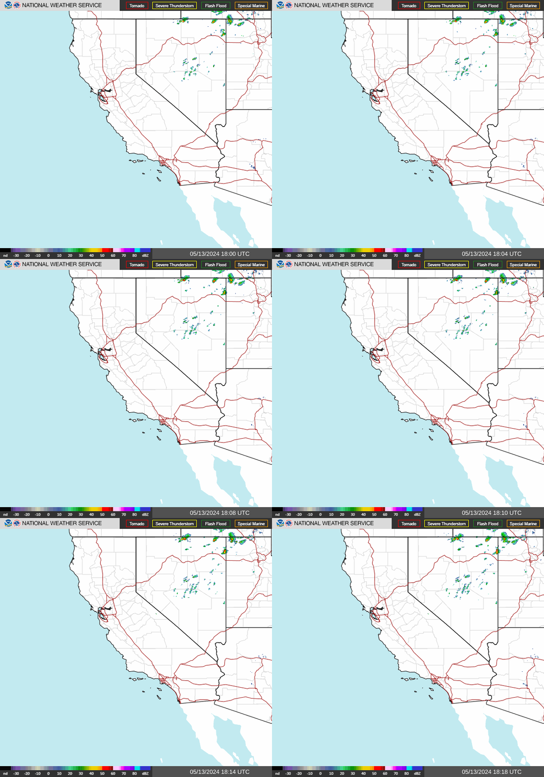
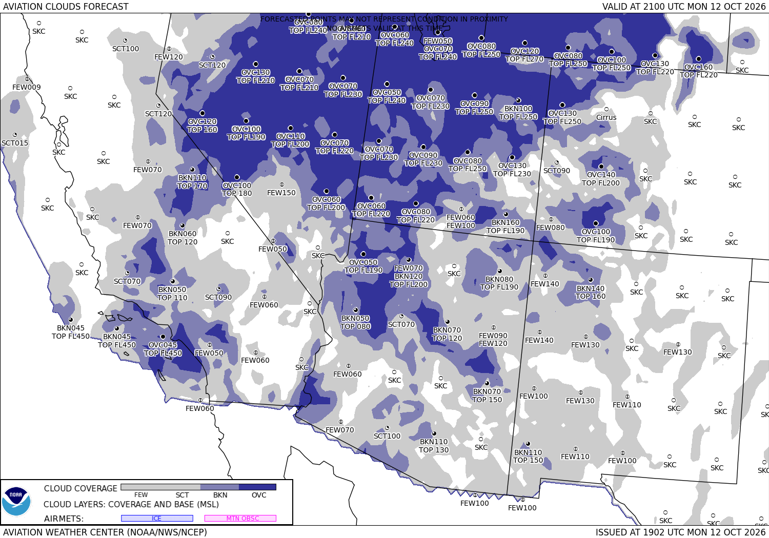
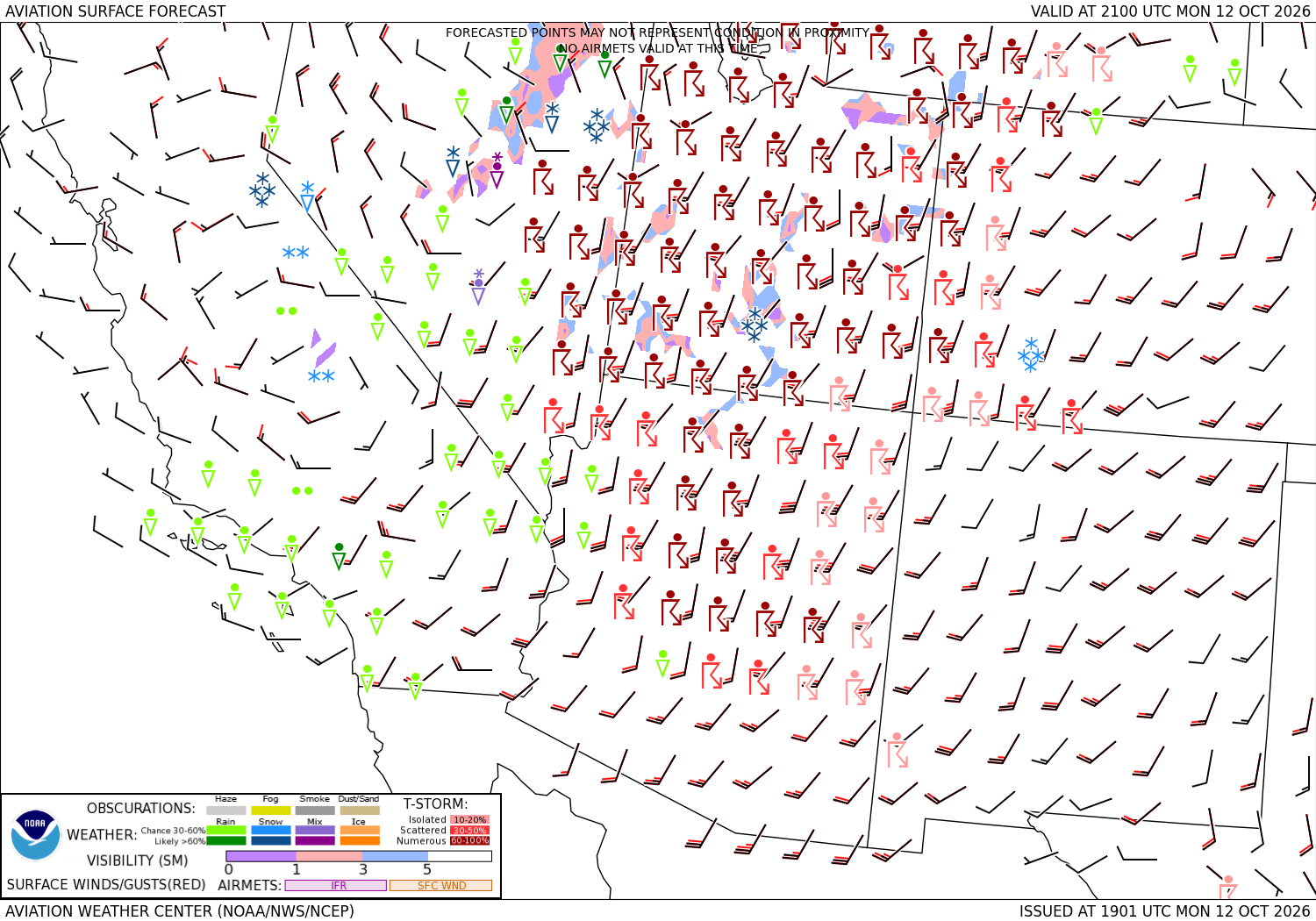
Radar and forecast charts for the regions crossed government pictures, the latest each time the page loads · the turbulence and icing forecasts: turbulence ↗ · icing ↗





Sources: the Aviation Weather Center's data service (SIGMETs, AIRMETs, graphical AIRMETs, pilot reports, winds and temperatures aloft, observations and terminal forecasts), the National Weather Service radar, the Weather Prediction Center's charts, the FAA's temporary flight restriction list and shapes, and the FAA's airport file for the positions, elevations and magnetic variation. Fetched when the page is viewed and kept a few minutes. Each leg is the straight line between its two airports; airways, terrain and airspace are not considered. The airports in detail: Harry Reid International, Montrose Regional.