
Whidbey Island Naval Air Station (Ault Field)
NUW · KNUW · Oak Harbor, Washington · Island County · map
Whidbey Island Naval Air Station (Ault Field) is a private airport owned by U S Navy, 3 miles north of Oak Harbor, Washington, 47 feet above sea level. It has 2 runways; the longest, 14/32, is 8,001 feet of concrete. It has a control tower and fuel (100LL avgas, JP-5, JP-8).
Private use: permission from the owner is required before landing here.
Weather right now KNUW · observed 4:53 pm PDT (23:53 UTC), 21 minutes ago
VFR good flying weather
- Wind from the west-northwest (300°) at 10 knots
- Visibility 10 miles or more
- Sky: a few clouds at 3,500 feet, a few clouds at 6,500 feet
- Temperature 56°F (13°C), dew point 44°F (7°C)
- Altimeter 29.94 inHg
The forecast issued Sun 4:06 pm PDT (23:06 UTC), good until Mon 4:00 pm PDT (23:00 UTC)
- From Sun 4:00 pm PDT (23:00 UTC): wind from the northwest at 11 knots, a few clouds at 5,000 feet
- From Sun 8:00 pm PDT (03:00 UTC): wind light and variable, am dust storm, clear skies
The codes as issued (METAR and TAF)
METAR KNUW 112353Z 30010KT 10SM FEW035 FEW065 13/07 A2994 RMK AO2 SLP142 T01330067 10156 20111 55007 $
TAF KNUW 112306Z 1123/1223 31011KT 9999 FEW050 QNH2991INS FM120300 VRB06KT 9999 SKC QNH2992INS LAST NO AMDS AFT 1205 NEXT 1307 TX13/1223Z TN09/1213Z FS30243
From the National Weather Service's aviation weather service, refreshed every few minutes; times are local to the airport with UTC in brackets. For a flight, get your briefing from Flight Service or an approved provider.
The airport
- Codes
- FAA NUW · ICAO KNUW
- Kind
- Airport · private use, permission required · owned by the Navy
- Owner
- U S Navy
- Elevation
- 47 feet above sea level
- Control tower
- A control tower with radar approach control · around the clock
- Attended
- around the clock
- Lights
- runway lights see the remarks below; beacon sunset to sunrise
- Fuel and services
- 100LL avgas, JP-5, JP-8; the services card below
- On the chart
- Seattle sectional
- Magnetic variation
- 18E
- In the FAA's files since
- January 1950
Runways 2
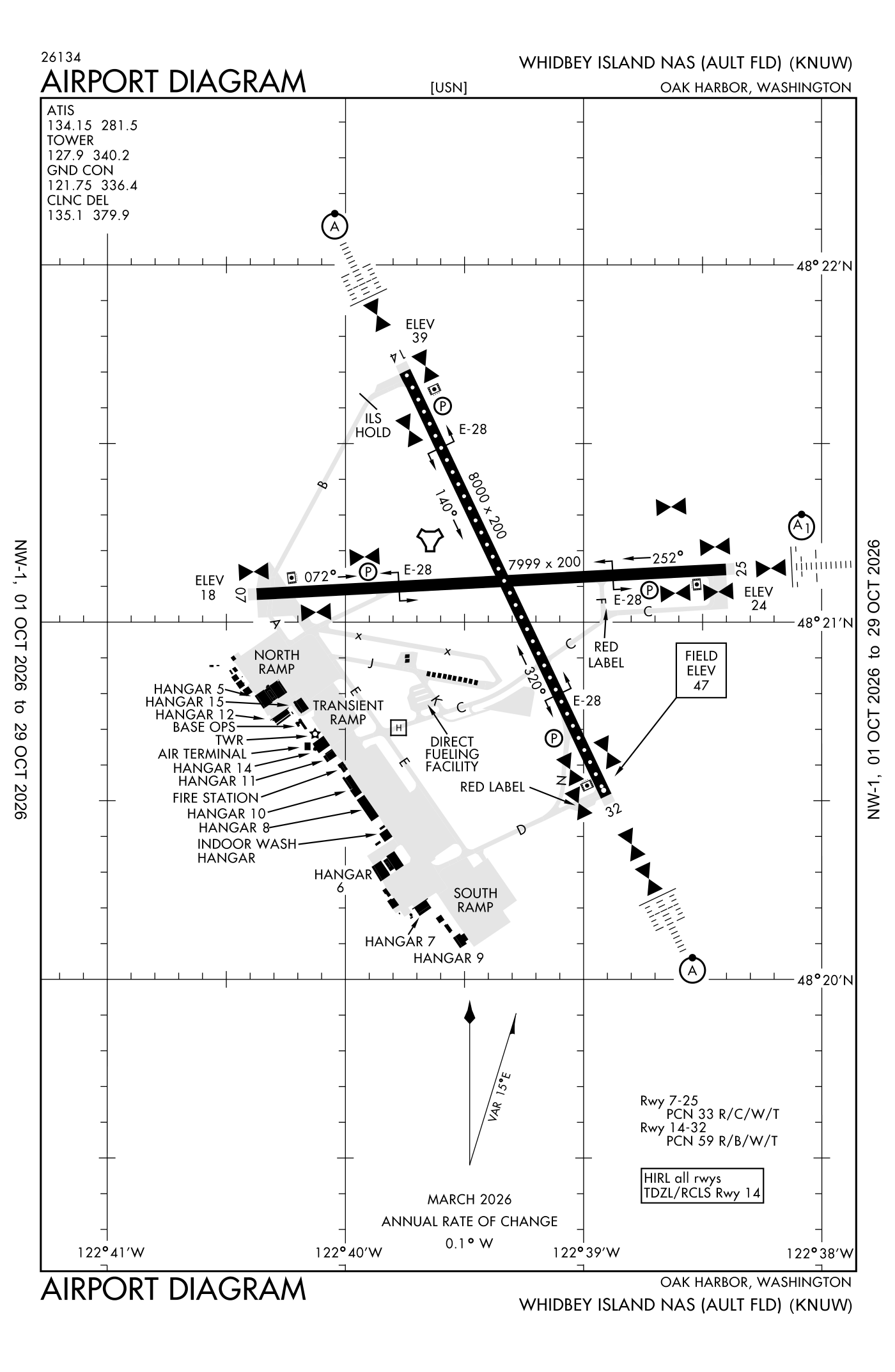
For understanding the field, not for navigation.
| Runway | Length × width | Surface | Lights |
|---|---|---|---|
| 14/32 | 8,001 × 200 ft | Concrete, good | High-intensity lights |
| 07/25 | 7,999 × 200 ft | Concrete, good | High-intensity lights |
- Runway 14: ILS with DME, PAPI, four lights on the left, approach lights with sequenced flashers (ALSF-2)
- Runway 32: PAPI, four lights on the left, approach lights with sequenced flashers (ALSF-2)
- Runway 07: PAPI, four lights on the left
- Runway 25: PAPI, four lights on the left, approach lights with sequenced flashers (ALSF-1)
Radio frequencies
| ATIS (recorded airport information) | 134.15 | Whidbey |
| Clearance delivery | 124.15 | |
| Clearance delivery Pre Taxi Clearance · Clearance delivery | 135.1 | Whidbey |
| Ground | 121.75 | Whidbey |
| Tower | 127.9 | Whidbey |
| Approach and departure · Class C airspace · Madee Rnav Star West | 118.2 | Whidbey |
| Approach and departure · Class C airspace · Madee Rnav Star East | 120.7 | Whidbey |
| Emergency | 121.5 | Whidbey |
Automated weather (ASOS), by phone 360-257-8813.
Aircraft registered in Oak Harbor from the FAA register
49 aircraft are registered to owners in Oak Harbor, Washington: 43 piston singles, 4 piston twins, 1 turboprop, 1 balloon. Not every one of them is based at this airport; the based-aircraft count above is the FAA's figure for this airport alone.
Individuals are counted, not named (the site's policy at this time). All aircraft registered in Washington.
Fuel and services as reported to the FAA
- Fuel
- 100LL avgas, JP-5, JP-8
- Oxygen
- bulk oxygen (high- and low-pressure)
Other fields with jet fuel nearby: Delaurentis Airport (6 nm south), Anacortes Airport (9 nm north), Skagit Regional (12 nm northeast).
The FAA's file records what is sold and done at the field, as the airport manager reports it, not who sells it or the price; fuel sellers (FBOs) are not named in any public file. Airports selling jet fuel in Washington · avgas.
Accidents and incidents at or near this airport NTSB records · 2 since 1982, 0 fatal
Cases the NTSB recorded with this as the nearest airport, newest first. Each opens the full report in plain English. The country as a whole: Where accidents happen.
Nearby within 30 nautical miles
The FAA's remarks as written in the airport file, spelled out
- Available only during hours of operation.
- Runway 14/32 portion of southeast end between 3000 and 2000 feet remaining mkr not fully visible from the control tower.
- Traffic pattern - overhead initial for runways 7, 14, 32 4NM 2500', runway 25 6NM 3000'; overhead break 1500'; pattern altitude 1000'.
- See flip AP/1.
- SERVICE- jasu - 1 (NC-10C), 1 (GTC-85/GTE-85), 1(MSU-200NAV/ A/U47A-5 FUEL-J8 FLUID-SP presair DE-ICE (2 hour PN required). Tran ALERT- tran crews must provide technical direct/assistance in service/maintenance to include direct supervision of fueling. Ltd service/maintenance available 1500-2300Z++ MON-FRI. no maintenance Saturday, sunand holidays. Air terminal operates 1400-0200Z++, as rqr OT.
- Ols lenses available to all runway.
- High-intensity runway lights and sfl unavailable to runway 7. Rcll available to runway 14-32 only.
- Operations duty officer C360-257-2681, dsn 820-2681.
- Ctn: landing signal officer shelter 15 feet above ground level, 32 feet from runway edge, located left side runway, 558 feet from runway 07 thld and 400 feet from thld on runway 14, 25 and 32. Large aircraft exer ctn. Extreme ctn required for back taxi in last 1000 feet of all runways.
- Ctn: no weps loading or offloading between HN.
- Dct reful facility lanes not available to tran aircraft.
- Service - PAPI runway 07/25 and runway 14/32 H24.
Connections how this airport links to the rest of the register
- Aircraft registered in Oak Harbor 49 aircraft · 43 piston singles, 4 piston twins, 1 turboprops
- NTSB accidents and incidents at or near this airport 2 since 1982 · 0 fatal
- Accidents and incidents in Washington 2,709 since 1982 · 360 in the last ten years
- Nearby landing places within 30 nautical miles 8 airports, heliports and seaplane bases
- Public-use airports in Washington 131 landing places
- Washington 10,417 aircraft registered
The whole map of how records connect · these connections as data: /graph/airport/NUW.json.
Facts from the FAA's airport file effective October 1, 2026, written out in plain English; weather from the National Weather Service's aviation weather service; registered aircraft from the FAA register as of October 9, 2026; accidents from the NTSB's public database. Owners are shown only when they are an organisation; no person is named. Check the official sources before a flight: this page is for understanding an airport, not for planning one.