
New River Marine Corps Air Station (Mccutcheon Field)
NCA · KNCA · Jacksonville, North Carolina · Onslow County · map
New River Marine Corps Air Station (Mccutcheon Field) is a private airport owned by the US Navy, 3 miles south of Jacksonville, North Carolina, 26 feet above sea level. It has 2 runways; the longest, 05/23, is 5,125 feet of asphalt. It has a control tower.
Private use: permission from the owner is required before landing here.
Weather right now KNCA · observed 5:56 pm EDT (21:56 UTC), 59 minutes ago
VFR good flying weather
- Wind from the north-northeast (030°) at 8 knots
- Visibility 7 miles
- Sky: a few clouds at 5,000 feet, a few clouds at 20,000 feet
- Temperature 73°F (23°C), dew point 53°F (12°C)
- Altimeter 30.05 inHg
The forecast issued Tue 8:00 am EDT (12:00 UTC), good until Wed 10:00 am EDT (14:00 UTC)
- From Tue 7:00 am EDT (11:00 UTC): wind from the northeast at 6 knots, a few clouds at 10,000 feet
- Changing between Tue 9:00 am EDT (13:00 UTC) and 11:00 am EDT (15:00 UTC) to: wind from the east-northeast at 7 knots, gusting to 18, scattered clouds at 4,000 feet
- At times between Tue 11:00 am EDT (15:00 UTC) and 5:00 pm EDT (21:00 UTC): wind from the east-northeast at 8 knots
- From Tue 5:00 pm EDT (21:00 UTC): wind from the northeast at 7 knots, a few clouds at 7,000 feet
- Changing between Wed 3:00 am EDT (07:00 UTC) and 5:00 am EDT (09:00 UTC) to: wind from the east-northeast at 7 knots, scattered clouds at 2,000 feet
The codes as issued (METAR and TAF)
METAR KNCA 062156Z 03008KT 7SM FEW050 FEW200 23/12 A3005 RMK SLP177 T02280117
TAF COR KNCA 061200Z 0611/0714 04006KT 9999 FEW100 531609 532507 QNH3007INS BECMG 0613/0615 06007G18KT 9999 SCT040 531609 532507 QNH3004INS TEMPO 0615/0621 06008KT FM062100 05007KT 9999 FEW070 531609 532507 QNH3000INS BECMG 0707/0709 07007KT 9999 SCT020 500000 QNH2999INS TX23/0618Z TN14/0709Z COR 1244
From the National Weather Service's aviation weather service, refreshed every few minutes; times are local to the airport with UTC in brackets. For a flight, get your briefing from Flight Service or an approved provider.
The airport
- Codes
- FAA NCA · ICAO KNCA
- Kind
- Airport · private use, permission required · owned by the Navy
- Owner
- US Navy
- Elevation
- 26 feet above sea level
- Control tower
- A control tower with radar approach control · operates 1 oct-30 apr 1300-0600z++ mon-thu; 1300-2400z++ friday; 1 may-30 sep 1400-0700z++ mon-thu; 1400-0100z++ friday
- Attended
- Monday to Thursday, 1:00 pm to 0600z++; Friday, 1:00 pm to 0000z++; Saturday, sunday/holidays/closed
- Lights
- runway lights see the remarks below; beacon sunset to sunrise
- On the chart
- Charlotte sectional
- Magnetic variation
- 8W
- In the FAA's files since
- August 1944
Runways 2
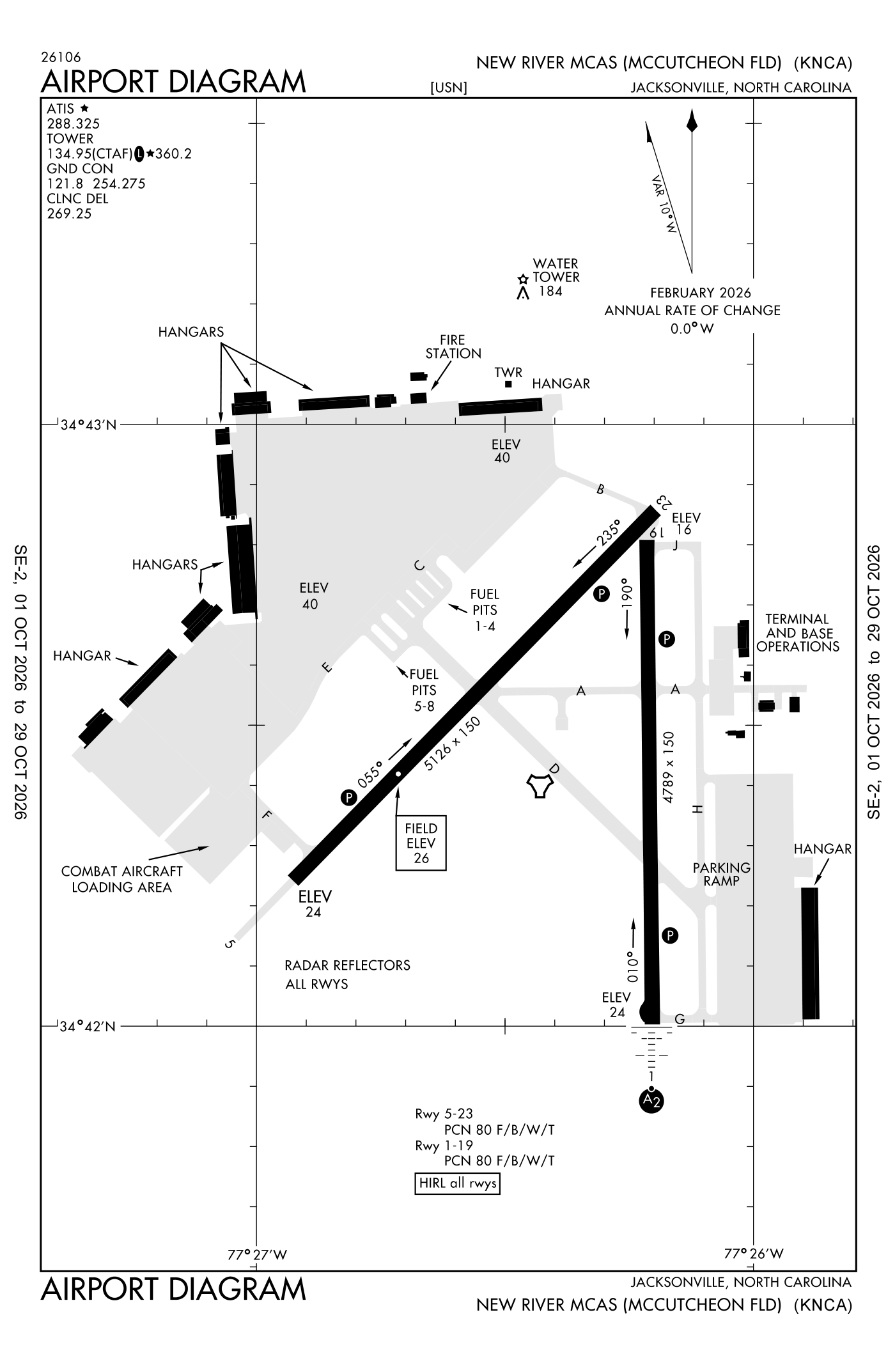
For understanding the field, not for navigation.
| Runway | Length × width | Surface | Lights |
|---|---|---|---|
| 05/23 | 5,125 × 150 ft | Asphalt | High-intensity lights |
| 01/19 | 4,789 × 150 ft | Asphalt | High-intensity lights |
- Runway 05: PAPI, four lights on the left
- Runway 23: PAPI, four lights on the left
- Runway 01: ILS with DME, PAPI, four lights on the right, SALSF
- Runway 19: PAPI, four lights on the left
Radio frequencies
| Common traffic advisory (CTAF) · Tower | 134.95 | New River |
| Ground | 121.8 | New River |
| Approach and departure | 119.35 | New River |
| Arrival | 124.85 | New River |
| Emergency | 121.5 | New River |
Aircraft registered in Jacksonville from the FAA register
29 aircraft are registered to owners in Jacksonville, North Carolina: 23 piston singles, 3 drones, 1 turboprop, 1 helicopter, 1 business jet. Not every one of them is based at this airport; the based-aircraft count above is the FAA's figure for this airport alone.
Individuals are counted, never named. All aircraft registered in North Carolina.
Accidents and incidents at or near this airport NTSB records
No NTSB accident or incident records name this airport.
Nearby within 30 nautical miles
The FAA's remarks as written in the airport file
- Light: runway 19 and 23 threshold light vary FR 1 feet to 15 feet FR edge of the pavement.
- Non-standard pcl all runways vhf 120.0: 3 clicks step 1; 5 clicks step 3; 7 clicks off. Expect 20 second delay for runway lights to activate. Activate PAPI runway 05 and 23; high-intensity runway lights runway 01/19, runway 05/23 - the common traffic frequency.
- Non vstol tactical jets proh from landing.
- Afld hours subj to chg by NOTAM. see flip AP/1 supplementary airport rmk.
- Restricted: taxiway 'C' and taxiway 'E' closed to C-130 and larger aircraft.
- Caution: bird haz OCT-APR. wildlife haz on airport, especially sunset to sunrise.
- Lighting available only durg operating hours.
- Misc: automated weather (ASOS) weather does not adjust for DT, status will indicate UTC-5.
- Men and equipment operating on movement areas when tower is closed.
- Fuel: J5. Hot fuel service available dur published field hour for R/west aircraft only. Cold fuel service available 1300Z++ until two hour prior to field closure MON-THU and 1300-0000Z++ Friday.
- Rmk: military aircraft operations conducted outside of publ hours. Use frequency 360.2.
Facts from the FAA's airport file effective October 1, 2026, written out in plain English; weather from the National Weather Service's aviation weather service; registered aircraft from the FAA register as of October 5, 2026; accidents from the NTSB's public database. Owners are shown only when they are an organisation; no person is named. Check the official sources before a flight: this page is for understanding an airport, not for planning one.