
Langley Air Force Base
LFI · KLFI · Hampton, Virginia · Hampton County · map
Langley Air Force Base is a private airport owned by Usaf, 3 miles north of Hampton, Virginia, 8 feet above sea level. Its one runway, 08/26, is 10,002 feet of concrete. It has a control tower.
Private use: permission from the owner is required before landing here.
Weather right now KLFI · observed 12:55 am EDT (04:55 UTC), 54 minutes ago
VFR good flying weather
- Wind from the west (260°) at 8 knots
- Visibility 10 miles or more
- Sky: overcast at 5,500 feet
- Temperature 72°F (22°C), dew point 64°F (18°C)
- Altimeter 29.74 inHg
The forecast issued Sun 1:32 pm EDT (17:32 UTC), good until Mon 6:00 pm EDT (22:00 UTC)
- From Sun 1:00 pm EDT (17:00 UTC): wind from the south-southwest at 12 knots, gusting to 18, overcast at 1,000 feet MVFR
- At times between Sun 1:00 pm EDT (17:00 UTC) and 4:00 pm EDT (20:00 UTC): a broken layer at 700 feet, overcast at 1,000 feet IFR
- Changing between Sun 2:00 pm EDT (18:00 UTC) and 3:00 pm EDT (19:00 UTC) to: wind from the south at 15 knots, gusting to 20, light rain showers, overcast at 1,500 feet MVFR
- At times between Sun 6:00 pm EDT (22:00 UTC) and 10:00 pm EDT (02:00 UTC): wind from the south-southeast at 15 knots, gusting to 25, light thunderstorms with rain, overcast at 1,500 feet MVFR
- Changing between Sun 9:00 pm EDT (01:00 UTC) and 10:00 pm EDT (02:00 UTC) to: wind from the southwest at 15 knots, gusting to 25, scattered clouds at 1,000 feet, a broken layer at 1,500 feet MVFR
- Changing between Mon 5:00 am EDT (09:00 UTC) and 6:00 am EDT (10:00 UTC) to: wind from the west-southwest at 15 knots, gusting to 25, light rain showers, a broken layer at 1,500 feet MVFR
- Changing between Mon 3:00 pm EDT (19:00 UTC) and 4:00 pm EDT (20:00 UTC) to: wind from the northwest at 12 knots, gusting to 18, am dust storm, a broken layer at 2,500 feet MVFR
The codes as issued (METAR and TAF)
METAR KLFI 120455Z AUTO 26008KT 10SM OVC055 22/18 A2974 RMK AO2 SLP077 T02200178 402580210 $
TAF AMD KLFI 111732Z 1117/1222 20012G18KT 9999 OVC010 QNH2996INS TEMPO 1117/1120 BKN007 OVC010 BECMG 1118/1119 18015G20KT 8000 -SHRA OVC015 QNH2997INS TEMPO 1122/1202 16015G25KT 4800 -TSRA OVC015 BECMG 1201/1202 22015G25KT 9999 NSW SCT010 BKN015 QNH2968INS BECMG 1209/1210 25015G25KT 6000 -SHRA BKN015 QNH2970INS BECMG 1219/1220 31012G18KT 9999 NSW BKN025 QNH2984INS TX27/1118Z TN15/1211Z LAST NO AMDS AFT 1117 NEXT 1310
From the National Weather Service's aviation weather service, refreshed every few minutes; times are local to the airport with UTC in brackets. For a flight, get your briefing from Flight Service or an approved provider.
The airport
- Codes
- FAA LFI · ICAO KLFI
- Kind
- Airport · private use, permission required · owned by the Air Force
- Owner
- Usaf
- Elevation
- 8 feet above sea level
- Control tower
- A control tower · operates 1100-0300z++ mon-fri; 1300-2100z++ wk end to support reg schedule drill (rsd) guard wk end once a month; closed federal holidays and acc down days unless operations apv by 1 fwcc.
- Attended
- Monday to Friday, 11:00 am to 0300z++; weekends, 1:00 pm to 2100z++
- Lights
- beacon sunset to sunrise
- Fuel and services
- no fuel reported; the services card below
- On the chart
- Washington sectional
- Magnetic variation
- 10W
- In the FAA's files since
- April 1943
Runway
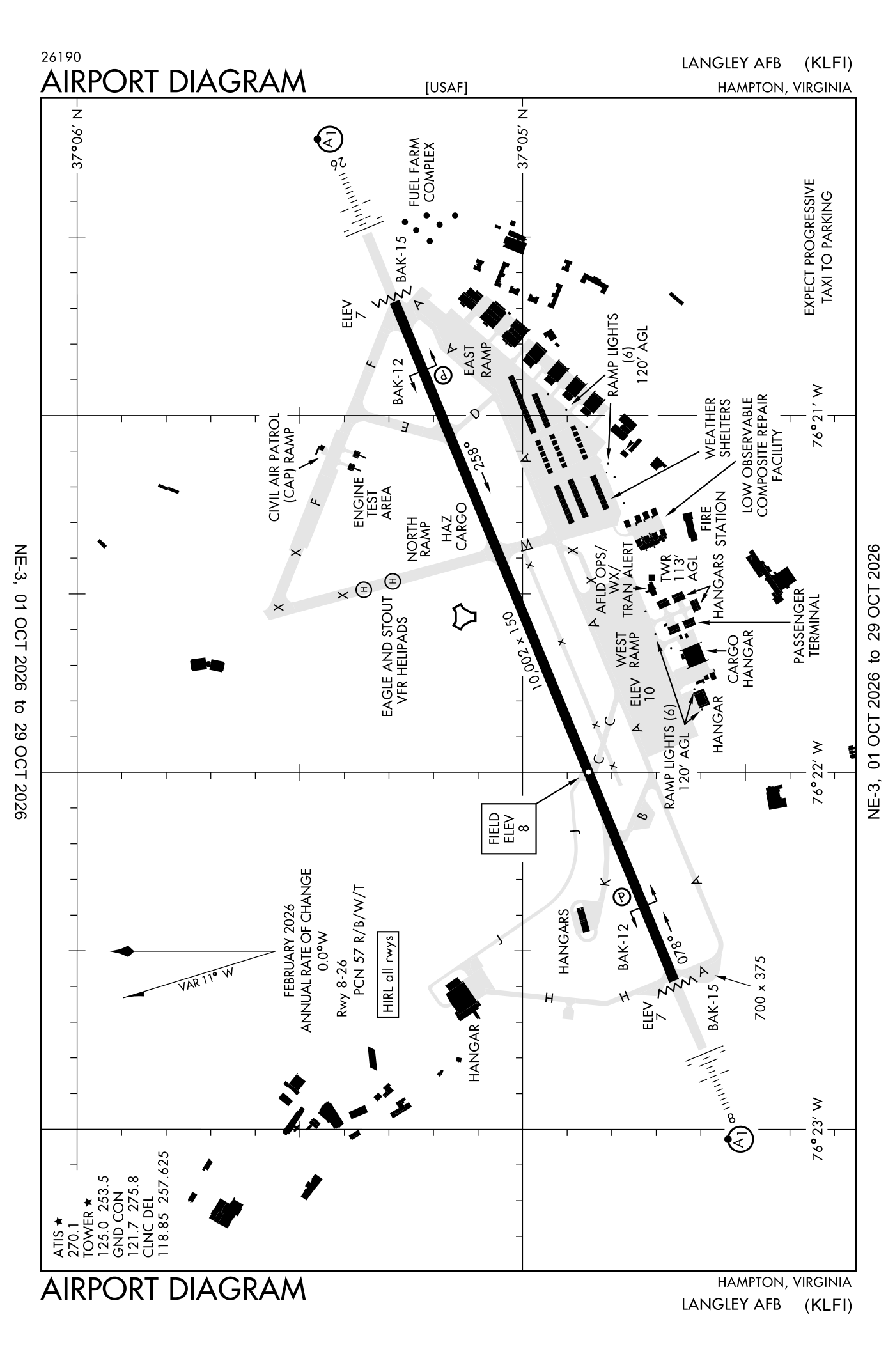
For understanding the field, not for navigation.
| Runway | Length × width | Surface | Lights |
|---|---|---|---|
| 08/26 | 10,002 × 150 ft | Concrete | High-intensity lights |
- Runway 08: ILS, PAPI, four lights on the left, approach lights with sequenced flashers (ALSF-1)
- Runway 26: localizer and glideslope, PAPI, four lights on the left, approach lights with sequenced flashers (ALSF-1)
Radio frequencies
| Clearance delivery | 118.85 | Langley |
| Ground | 121.7 | Langley |
| Tower | 125.0 | Langley |
| Approach and departure arriving from headings 311 to 009 | 124.9 | Langley |
| Approach (secondary) Departure (secondary) arriving from headings 311 to 009 | 125.7 | Langley |
| Approach and departure arriving from headings 180 to 310 | 127.9 | Langley |
| Approach and departure arriving from headings 010 to 179 | 134.875 | Langley |
| Emergency | 121.5 | Langley |
| Kohls and star · Outla and star | 118.9 | Langley |
| Nasa and operations | 123.375 | Langley |
| Pre-taxi clearance | 142.3 | Langley |
Aircraft registered in Hampton from the FAA register
73 aircraft are registered to owners in Hampton, Virginia: 50 drones, 12 piston singles, 4 piston twins, 2 helicopters, 2 business jets. Not every one of them is based at this airport; the based-aircraft count above is the FAA's figure for this airport alone.
Companies and organisations in town with two or more aircraft:
Individuals are counted, not named (the site's policy at this time). All aircraft registered in Virginia.
Fuel and services as reported to the FAA
- Fuel
- none reported
- Repairs
- airframe and engine: major repairs
- Parking
- hangars
- Oxygen
- bulk oxygen (low-pressure)
- Also here
- cargo handling
Nearest fields reporting jet fuel: Newport News/Williamsburg International (7 nm northwest), Norfolk International (14 nm southeast), Hampton Roads Executive (19 nm south), Waltrip Williamsburg Executive Airport (19 nm northwest).
Nearest fields reporting avgas: Newport News/Williamsburg International (7 nm northwest), Norfolk International (14 nm southeast), Hampton Roads Executive (19 nm south), Waltrip Williamsburg Executive Airport (19 nm northwest).
The FAA's file records what is sold and done at the field, as the airport manager reports it, not who sells it or the price; fuel sellers (FBOs) are not named in any public file. Airports selling jet fuel in Virginia · avgas.
Accidents and incidents at or near this airport NTSB records · 3 since 1982, 2 fatal
Cases the NTSB recorded with this as the nearest airport, newest first. Each opens the full report in plain English. The country as a whole: Where accidents happen.
Nearby within 30 nautical miles
The FAA's remarks as written in the airport file, spelled out
- Rescue and firefighting (ARFF) is cat 8 with 8100 gal of capability. Steady rescue and firefighting (ARFF) condition for Langley Afb is optimum level of service (ols) for cat 1-10. _.
- BAK-15(NI) (60 feet ovrn) hook BAK-12B(B) (1100 feet).
- Hook BAK-12B(B) (1002 feet) BAK-15(NI) (44 feet ovrn).
- Runway 08/26 threshold light gated, mid 70 feet not working/removed.
- A-GEAR: BAK-15 cable always in place runway 26 ovrn and net raised at pilots required. BAK-12B(B) pendant cable always in place. BAK-12B extn.
- Jasu: 2(M32A-60) MC-11) 4(a/M 32A-86).
- Fuel: a++. expect up to 30 minimum delay.
- Oil: O-133-148-156 soap.
- Tran alert: operates 1130-0430Z++ wkd, closed wkend, holidays, and acc down days. Exp progressive taxi to prk. Flw me service available upon required.
- Caution: inst IFR and VFR HI performance ftr traffic within the class D airspace: extv unctl general avn traffic below 3000 feet over james river and chesapeake bay. Departure traffic do not exceed 1000 feet on climbout until departure end of runway.
- Caution: laser light beam haz to drct visual obsn will be conducted at nasa Langley research cntr within 1/2 NM rad of 37 degrees 06.3 minimum north 76 degrees 22.7 minimum west. Strong caution is advs. Laser beam may be injurious to pilots/passenger eyes within all altitude of light source. CK NOTAM for date/time/duration/affected altitude.
- Caution: weather obsn site located 080-250 due to building.
Connections how this airport links to the rest of the register
- Aircraft registered in Hampton 73 aircraft · 50 drones, 12 piston singles, 4 piston twins
- NASA Langley Research Center 53 aircraft in town
- NTSB accidents and incidents at or near this airport 3 since 1982 · 2 fatal
- Accidents and incidents in Virginia 1,361 since 1982 · 230 in the last ten years
- Nearby landing places within 30 nautical miles 8 airports, heliports and seaplane bases
- Public-use airports in Virginia 64 landing places
- Virginia 5,986 aircraft registered
The whole map of how records connect · these connections as data: /graph/airport/LFI.json.
Facts from the FAA's airport file effective October 1, 2026, written out in plain English; weather from the National Weather Service's aviation weather service; registered aircraft from the FAA register as of October 9, 2026; accidents from the NTSB's public database. Owners are shown only when they are an organisation; no person is named. Check the official sources before a flight: this page is for understanding an airport, not for planning one.