
Hunter Army Airfield
SVN · KSVN · Savannah, Georgia · Chatham County · map
Hunter Army Airfield is a private airport, 2 miles southwest of Savannah, Georgia, 41 feet above sea level. Its one runway, 10/28, is 11,375 feet of asphalt. It has a control tower and fuel (Jet A with additives).
Private use: permission from the owner is required before landing here.
Weather right now KSVN · observed 6:55 pm EDT (22:55 UTC), 38 minutes ago
MVFR flyable but watch the ceiling and visibility
- Wind from the northeast (040°) at 6 knots
- Visibility 10 miles or more
- Sky: overcast at 2,100 feet
- Temperature 74°F (24°C), dew point 67°F (19°C)
- Altimeter 29.94 inHg
The forecast issued Tue 3:43 pm EDT (19:43 UTC), good until Wed 7:00 pm EDT (23:00 UTC)
- From Tue 3:00 pm EDT (19:00 UTC): wind from the northeast at 10 knots, gusting to 15, a broken layer at 2,000 feet MVFR
- Changing between Tue 8:00 pm EDT (00:00 UTC) and 9:00 pm EDT (01:00 UTC) to: wind from the north-northeast at 9 knots, scattered clouds at 2,500 feet
The codes as issued (METAR and TAF)
METAR KSVN 062255Z 04006KT 10SM OVC021 24/19 A2994 RMK AO2A SLP142 T02360193 $
TAF AMD KSVN 061943Z 0619/0723 05010G15KT 9999 BKN020 QNH2993INS BECMG 0700/0701 03009KT 9999 SCT025 QNH2994INS TX25/0620Z TN19/0710Z
From the National Weather Service's aviation weather service, refreshed every few minutes; times are local to the airport with UTC in brackets. For a flight, get your briefing from Flight Service or an approved provider.
The airport
- Codes
- FAA SVN · ICAO KSVN
- Kind
- Airport · private use, permission required · owned by the Army
- Elevation
- 41 feet above sea level
- Control tower
- A control tower · 1230z ++ mon-0400z ++ saturday, except holidays.
- Attended
- around the clock
- Lights
- runway lights see the remarks below; beacon sunset to sunrise
- Fuel
- Jet A with additives
- On the chart
- Atlanta sectional
- Magnetic variation
- 4W
- In the FAA's files since
- April 1940
Runway
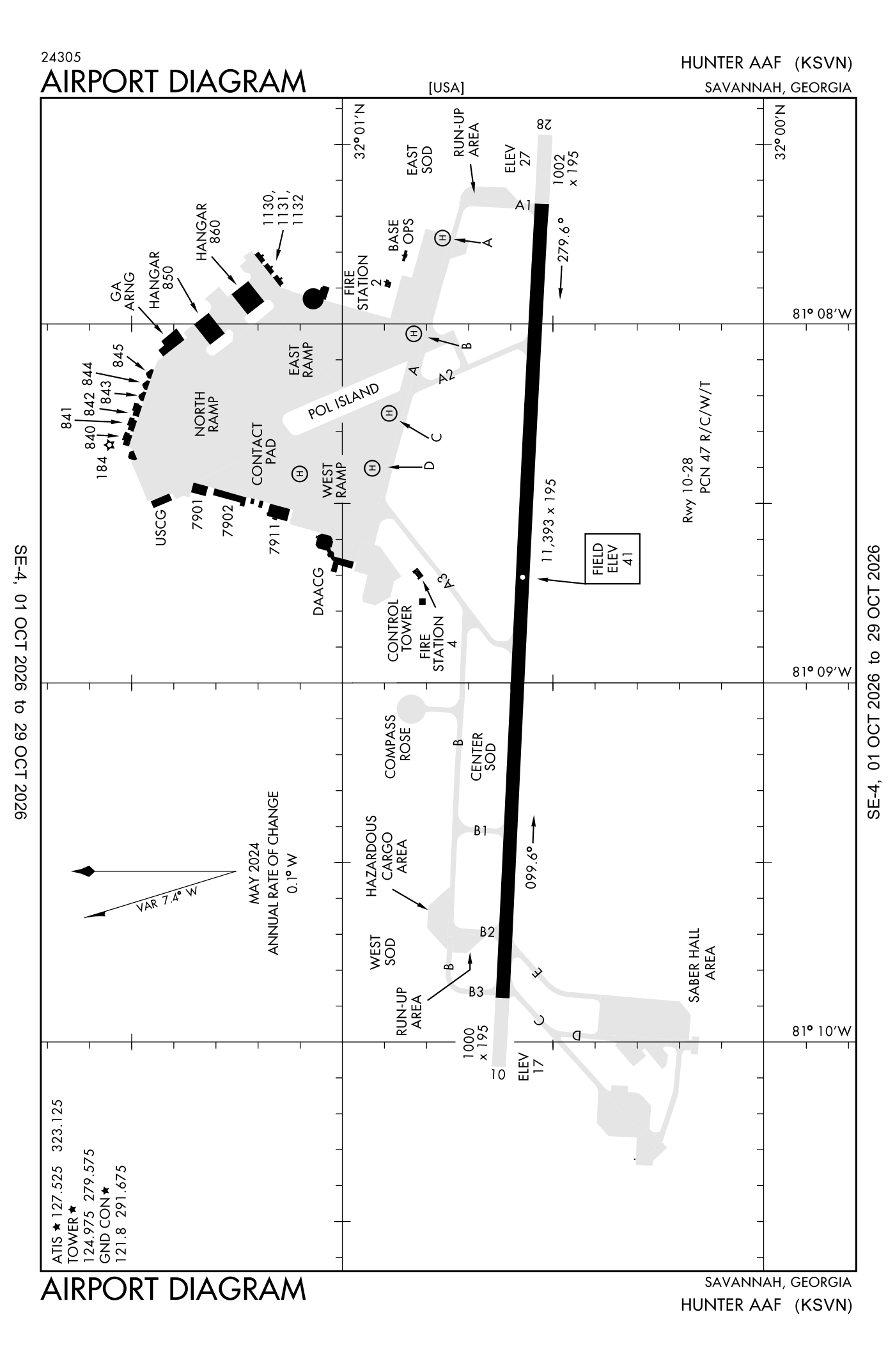
For understanding the field, not for navigation.
| Runway | Length × width | Surface | Lights |
|---|---|---|---|
| 10/28 | 11,375 × 197 ft | Asphalt | High-intensity lights |
- Runway 10: PAPI, four lights on the right, non-standard approach lights
- Runway 28: ILS with DME, PAPI, four lights on the left, approach lights with sequenced flashers (ALSF-1)
Radio frequencies
| Common traffic advisory (CTAF) · Tower | 124.975 | Hunter |
| ATIS (recorded airport information) | 127.525 | Hunter |
| Ground | 121.8 | Hunter |
| Approach and departure | 120.4 | Hunter |
| Approach and departure arriving from headings 011 to 109 | 125.3 | Hunter |
| Emergency | 121.5 | Hunter |
| Pre-taxi clearance | 126.2 | Hunter |
| Savannah and center (remote transmitter) Low | 132.925 | Hunter |
| Surveillance radar and precision approach radar · Ground-controlled approach | 134.7 | Hunter |
Aircraft registered in Savannah from the FAA register
443 aircraft are registered to owners in Savannah, Georgia: 285 business jets, 110 piston singles, 29 turboprops, 8 piston twins, 6 helicopters. Not every one of them is based at this airport; the based-aircraft count above is the FAA's figure for this airport alone.
Companies and organisations in town with two or more aircraft:
Individuals are counted, never named. All aircraft registered in Georgia.
Accidents and incidents at or near this airport NTSB records · 4 since 1982, 1 fatal
Cases the NTSB recorded with this as the nearest airport, newest first. Each opens the full report in plain English.
Nearby within 30 nautical miles
The FAA's remarks as written in the airport file
- Activate als runway 10; 3-STEP als runway 28; runway end identifier lights runway 10; PAPI runway 10 and 28; high-intensity runway lights runway 10/28 - the common traffic frequency when tower closed.
- U.S. confign TYPE-B 1500 feet long.
- NS abtmt: procedures in effect 0300Z-1200Z++ MON-SAT; 0300Z-1800Z++ Sunday. Practice multiple circling approach cat C, D, east not authorized below 1500 feet. No ovft of Savannah and sur populated areas below 1000 feet unless on approach to Hunter Aaf. Quiet hour 0230-1030Z++.
- Jasu: 3(AF M32A-86) 3(dnd CE12 equivalent) 1(dnd CE14 equivalent) 1(AF M32-95).
- Oil: O-156.
- Tran alert: ltd service available 1230-0400Z++ MON-SAT, except holidays.
- Caution: wildlife haz. Seagull haz.
- Traffic pattern: F/west 1500 feet, R/west 700 feet.
- Misc: R/west pilots planning to conduct operates within R3005 must rcv a rng briefing prior to operates. Briefing shall be accomplished at least 4 hour prior to flight on the reservation. Aviators briefed within the past 6 months may rcv fone update.
- See flip AP/1 supplementary airport rmk.
- Caution: taxiway 7E/W closed. No R/west hovering on west ramp without prior permission.
- Compass rose calibration out of service.
Facts from the FAA's airport file effective October 1, 2026, written out in plain English; weather from the National Weather Service's aviation weather service; registered aircraft from the FAA register as of October 5, 2026; accidents from the NTSB's public database. Owners are shown only when they are an organisation; no person is named. Check the official sources before a flight: this page is for understanding an airport, not for planning one.