
Moffett Federal Airfield
NUQ · KNUQ · Mountain View, California · Santa Clara County · map
Moffett Federal Airfield is a private airport, 3 miles north of Mountain View, California, 37 feet above sea level. It has 2 runways; the longest, 14L/32R, is 9,197 feet of concrete. It has a control tower and fuel (Jet A).
Private use: permission from the owner is required before landing here.
Weather right now KNUQ · observed 3:35 pm PDT (22:35 UTC), 7 minutes ago
VFR good flying weather
- Wind from the north (350°) at 15 knots
- Visibility 7 miles
- Temperature 68°F (20°C), dew point 50°F (10°C)
- Altimeter 29.60 inHg
No terminal forecast is issued for this station. The nearest forecast is usually at the closest larger airport.
The codes as issued (METAR and TAF)
METAR KNUQ 112235Z AUTO 35015KT 7SM CLR 20/10 A2960 RMK AO2
From the National Weather Service's aviation weather service, refreshed every few minutes; times are local to the airport with UTC in brackets. For a flight, get your briefing from Flight Service or an approved provider.
The airport
- Codes
- FAA NUQ · ICAO KNUQ
- Kind
- Airport · private use, permission required · publicly owned
- Elevation
- 37 feet above sea level
- Control tower
- A control tower · 1500-0700z++
- Attended
- around the clock
- Lights
- runway lights see the remarks below; beacon sunset to sunrise
- Fuel and services
- Jet A; the services card below
- On the chart
- San Francisco sectional
- Magnetic variation
- 16E
Runways 2
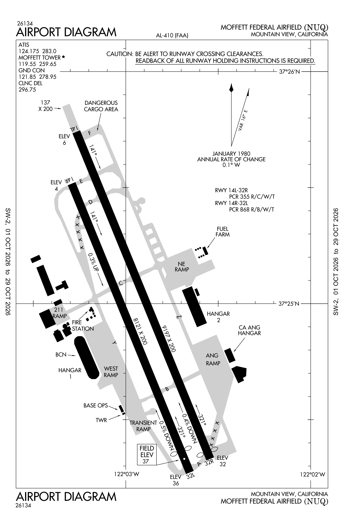
For understanding the field, not for navigation.
| Runway | Length × width | Surface | Lights |
|---|---|---|---|
| 14L/32R | 9,197 × 200 ft | Concrete | High-intensity lights |
| 14R/32L | 8,121 × 200 ft | Asphalt | High-intensity lights |
- Runway 14L: localizer with DME, PAPI, four lights on the left
- Runway 32R: ILS with DME, PAPI, four lights on the left, medium-intensity approach lights with runway alignment lights (MALSR), threshold displaced 191 ft
- Runway 32L: threshold displaced 600 ft
Radio frequencies
| Common traffic advisory (CTAF) · Tower | 119.55 | Moffett |
| ATIS (recorded airport information) · Nuq and aWOS-3PT | 124.175 | Moffett |
| Ground | 121.85 | Moffett |
| Approach · Departure | 120.1 | Moffett |
| Approach | 135.2 | Moffett |
| Approach (secondary) | 133.95 | Moffett |
| Approach (secondary) | 134.5 | Moffett |
| Emergency | 121.5 | Moffett |
| Woodside and dp | 121.3 | Moffett |
| Sfa | 134.1 | Moffett |
Automated weather (AWOS-3PT), by phone 650-386-0655.
Aircraft registered in Mountain View from the FAA register
51 aircraft are registered to owners in Mountain View, California: 35 piston singles, 6 electric and sustainable aircraft, 4 turboprops, 3 piston twins, 2 helicopters. Not every one of them is based at this airport; the based-aircraft count above is the FAA's figure for this airport alone.
Companies and organisations in town with two or more aircraft:
Individuals are counted, not named (the site's policy at this time). All aircraft registered in California.
Fuel and services as reported to the FAA
- Fuel
- Jet A
- Repairs
- none at the field, as reported
- Parking
- tie-downs
Nearest fields reporting avgas: Palo Alto Airport (4 nm northwest), Mineta San Jose International (7 nm southeast), San Carlos Airport (11 nm northwest), Reid-Hillview Of Santa Clara County (12 nm southeast).
Other fields with jet fuel nearby: Palo Alto Airport (4 nm northwest), Mineta San Jose International (7 nm southeast), San Carlos Airport (11 nm northwest).
The FAA's file records what is sold and done at the field, as the airport manager reports it, not who sells it or the price; fuel sellers (FBOs) are not named in any public file. Airports selling jet fuel in California · avgas.
Who works here from the FAA's certificate lists and the register
Repair stations in Mountain View:
- Matternet, INC Matternet develops commercial drone delivery systems, aircraft, ground infrastructure, and software for autonomous aerial logistics in urban and suburban environments.
Companies in the same town as this airport; not every one of them works from this field. All operators · all repair stations · all flight schools · all FBOs.
Accidents and incidents at or near this airport NTSB records · 1 since 1982, 0 fatal
Cases the NTSB recorded with this as the nearest airport, newest first. Each opens the full report in plain English. The country as a whole: Where accidents happen.
Nearby within 30 nautical miles
The FAA's remarks as written in the airport file, spelled out
- Bearing strength runway 14L: S64 T110 ST144 SBTT410 TDT528 TRT390).
- When tower closed, activate runway end identifier lights runway 14L; approach lights (MALSR) runway 32R; PAPI runway 14L and 32R; high-intensity runway lights runway 14L/32R and 14R/32L- the common traffic frequency.
- Lessee: planetary ventures
- FSS-OAKLAND OAK-NOTAM nuq
- Jet a avail 24 hours.
- Bearing strength runway 32R: S82 T142 ST175 TT300 DDT609, TDT814.
- Jasu - (AM32A-60) (AM32A-86).
- Fluid - SP lox - ltd available.
- Restricted - prior permission required alfd operations operates 24 hours, tran alert service 24 hours, C650-386-0677. Recommend sid, exp delay for radar vectors.
- Cstms/agricultural/img - cstms, agricultural, img available only by PN MON-FRI 1700-0100Z++ except holidays.
- Caution - possible strong updraft vicinity nasa/ames wind tunnel located west side of afld. Bird haz.
- NS abtmt - no jet departure runway 14L/R between hours of 0700-1300Z++.
Connections how this airport links to the rest of the register
- Aircraft registered in Mountain View 51 aircraft · 35 piston singles, 6 electric and sustainable aircraft, 4 turboprops
- Wisk Aero LLC 9 aircraft in town
- Edsoft Aviation LLC 2 aircraft in town
- Matternet, INC · repair station
- NTSB accidents and incidents at or near this airport 1 since 1982 · 0 fatal
- Accidents and incidents in California 9,069 since 1982 · 1,094 in the last ten years
- Nearby landing places within 30 nautical miles 8 airports, heliports and seaplane bases
- Public-use airports in California 244 landing places
- California 27,552 aircraft registered
The whole map of how records connect · these connections as data: /graph/airport/NUQ.json.
Facts from the FAA's airport file effective October 1, 2026, written out in plain English; weather from the National Weather Service's aviation weather service; registered aircraft from the FAA register as of October 9, 2026; accidents from the NTSB's public database. Owners are shown only when they are an organisation; no person is named. Check the official sources before a flight: this page is for understanding an airport, not for planning one.