
Miramar Marine Corps Air Station (Joe Foss Field)
NKX · KNKX · San Diego, California · San Diego County · map
Miramar Marine Corps Air Station (Joe Foss Field) is a private airport owned by the US Navy, 3 miles north of San Diego, California, 477 feet above sea level. It has 2 runways; the longest, 06L/24R, is 12,000 feet of concrete. It has a control tower.
Private use: permission from the owner is required before landing here.
Weather right now KNKX · observed 5:37 pm PDT (00:37 UTC), 15 minutes ago
VFR good flying weather
- Wind from the southwest (220°) at 5 knots, gusting to 17
- Visibility 7 miles
- Sky: a few clouds at 2,600 feet, a few clouds at 3,100 feet, overcast at 4,400 feet
- Temperature 66°F (19°C), dew point 57°F (14°C)
- Altimeter 29.78 inHg
The forecast issued Sun 5:00 pm PDT (00:00 UTC), good until Mon 11:00 pm PDT (06:00 UTC)
- From Sun 5:00 pm PDT (00:00 UTC): wind from the northwest at 5 knots, overcast at 5,000 feet VFR
- From Sun 11:00 pm PDT (06:00 UTC): wind from the northeast at 4 knots, scattered clouds at 1,500 feet
- From Mon 2:00 am PDT (09:00 UTC): wind from the north-northeast at 4 knots, mist, a broken layer at 700 feet IFR
- From Mon 9:00 am PDT (16:00 UTC): wind from the south at 6 knots, a broken layer at 2,000 feet MVFR
- From Mon 11:00 am PDT (18:00 UTC): wind from the west at 11 knots, scattered clouds at 2,500 feet
- From Mon 5:00 pm PDT (00:00 UTC): wind light and variable, overcast at 5,000 feet VFR
The codes as issued (METAR and TAF)
SPECI KNKX 120037Z 22005G17KT 7SM FEW026 FEW031 OVC044 19/14 A2978 RMK AO2 T01890139
TAF KNKX 120000Z 1200/1306 31005KT 9999 OVC050 QNH2978INS FM120600 04004KT 9999 SCT015 QNH2984INS FM120900 02004KT 4800 BR BKN007 QNH2983INS FM121600 18006KT 9999 NSW BKN020 QNH2991INS FM121800 26011KT 9999 SCT025 QNH2992INS FM130000 VRB03KT 9999 OVC050 QNH2989INS TX20/1221Z TN16/1213Z
From the National Weather Service's aviation weather service, refreshed every few minutes; times are local to the airport with UTC in brackets. For a flight, get your briefing from Flight Service or an approved provider.
The airport
- Codes
- FAA NKX · ICAO KNKX
- Kind
- Airport · private use, permission required · owned by the Navy
- Owner
- US Navy
- Elevation
- 477 feet above sea level
- Control tower
- A control tower · 1530-0800z mon-thu; 1630-0200z++ friday; closed saturday; 2200-0200z++sunday. field closed natl holidays.
- Attended
- Monday to Thursday, 3:30 pm to 0800z; Friday, 4:30 pm to 0200z++; Saturday, closed; Sunday, 10:00 pm to 0200z++; holidays, closed
- Lights
- runway lights see the remarks below; beacon sunset to sunrise
- Fuel and services
- no fuel reported; the services card below
- On the chart
- Los Angeles sectional
- Magnetic variation
- 12E
- In the FAA's files since
- February 1944
Runways 2
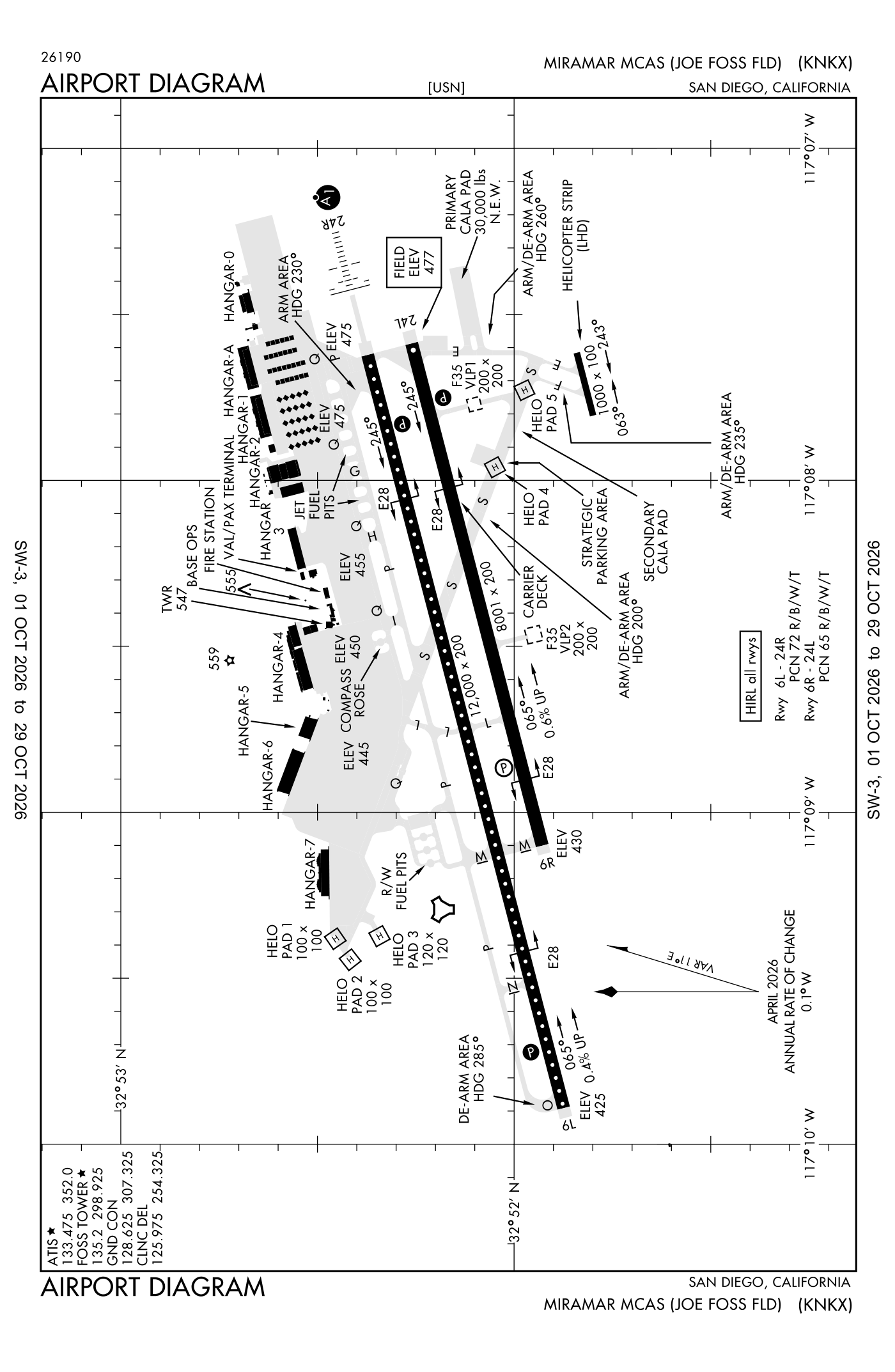
For understanding the field, not for navigation.
| Runway | Length × width | Surface | Lights |
|---|---|---|---|
| 06L/24R | 12,000 × 200 ft | Concrete | High-intensity lights |
| 06R/24L | 8,001 × 200 ft | Partially concrete | High-intensity lights |
- Runway 06L: PAPI, four lights on the left
- Runway 24R: ILS with DME, PAPI, four lights on the left, approach lights with sequenced flashers (ALSF-1)
- Runway 06R: PAPI, four lights on the left
- Runway 24L: PAPI, four lights on the left
Radio frequencies
| ATIS (recorded airport information) | 133.475 | Miramar |
| Clearance delivery | 125.975 | Miramar |
| Ground | 128.625 | Miramar |
| Tower | 135.2 | Miramar |
| Approach · Class B airspace · Departure 029-061 San 14,000 feet and below; 333-028 San 7,000 FT-11,000 feet | 132.2 | Miramar |
| Departure West | 119.6 | Miramar |
Aircraft registered in San Diego from the FAA register
683 aircraft are registered to owners in San Diego, California: 476 piston singles, 46 drones, 33 piston twins, 32 business jets, 31 helicopters. Not every one of them is based at this airport; the based-aircraft count above is the FAA's figure for this airport alone.
Companies and organisations in town with two or more aircraft:
Individuals are counted, not named (the site's policy at this time). All aircraft registered in California.
Fuel and services as reported to the FAA
- Fuel
- none reported
- Repairs
- none at the field, as reported
Nearest fields reporting jet fuel: Montgomery-Gibbs Executive (3 nm south), San Diego International (8 nm south), Gillespie Field (9 nm east), Ramona Airport (15 nm northeast).
Nearest fields reporting avgas: Montgomery-Gibbs Executive (3 nm south), San Diego International (8 nm south), Gillespie Field (9 nm east), Ramona Airport (15 nm northeast).
The FAA's file records what is sold and done at the field, as the airport manager reports it, not who sells it or the price; fuel sellers (FBOs) are not named in any public file. Airports selling jet fuel in California · avgas.
Who works here from the FAA's certificate lists and the register
Flight schools, flying clubs and college flight programmes in San Diego, by their names on the register:
- Coast Flight Training and Management INC 39 aircraft
- San Diego Community College District 7 aircraft The San Diego Community College District operates three credit colleges (San Diego City College, Mesa College, and San Diego Miramar College) and seven campuses of San Diego College of Continuing Education, serving approximately 90,000 stud
- Coast Flight Training & Management INC 3 aircraft
- Aa5A Flyers 1 aircraft Plus One Flyers is a member-oriented, non-profit flying club based in San Diego County, California.
- Armed Forces Aero Club 1 aircraft Armed Forces Aero Club is a nonprofit flying club in San Diego, California, organized for social and recreational flying.
- Armed Forces Aero Club INC 1 aircraft Armed Forces Aero Club is a nonprofit flying club in San Diego, California, organized for social and recreational flying purposes.
- Baja Flyers CORP INC 1 aircraft
- Baja Flyers INC 1 aircraft Plus One Flyers is a member-oriented, non-profit flying club based in San Diego County, California.
Charter operators and airlines based in San Diego:
- Latitude 33 Aviation, LLC 16 aircraft on the certificate
- Shier Aviation Corp 6 aircraft on the certificate
- Raven Helicopters, LLC 1 aircraft on the certificate
- San Diego Air Service, Inc. 1 aircraft on the certificate
Repair stations in San Diego:
- Amentum Services, INC
- Chromalloy Gas Turbine Corporation
- Coast Aviation Services
- Delta Group Electronics INC Delta Group Electronics is an electronics manufacturing services (EMS) provider with FAA Part 145 repair station certification.
- Flame Spray INC
- Gibbs Service Center INC Aircraft Service Center SD is a FAA Part 145 repair station in San Diego providing aircraft maintenance, avionics service, and repairs.
- Hm Aeronautics INC Montgomery Avionics and Aircraft Services is a repair station in San Diego, California that provides pitot/static certifications, avionics troubleshooting and installation, and light maintenance for LSA and experimental aircraft.
- Kontron America INC
- Pacific Aircraft Maintenance
- Safran Power Units San Diego LLC
- Shier Aviation CORP Corporate Helicopters is a helicopter operator based in San Diego, California, offering charter flights, tours, flight training, aerial filming and photography, helicopter sales, utility operations, and maintenance services throughout South
Companies in the same town as this airport; not every one of them works from this field. All operators · all repair stations · all flight schools · all FBOs.
Accidents and incidents at or near this airport NTSB records · 4 since 1982, 2 fatal
Cases the NTSB recorded with this as the nearest airport, newest first. Each opens the full report in plain English. The country as a whole: Where accidents happen.
Nearby within 30 nautical miles
The FAA's remarks as written in the airport file, spelled out
- Activate ALSF-1 runway 24R; PAPI runways 6L, 24R and 24L; high-intensity runway lights and CL runway 06L/24R - 298.925 or 135.2.
- Hook E28(B) (2490')
- Hook E28(B) (1052')
- Hook E28(B) (2301')
- Hook E28(B) (2300')
- Ols
- Ols
- Ols
- SF, ols
- Caution: water on the rubber BUILD-UP areas of the runway may produce poor traction and/or BA and standing water on runway may produce hydroplaning condition.
- NS abtmt: strictly enforced, mandatory pro and crs rules. All tran aircraft must review and sign noise abatement form with flight planning.
- Caution: high MID-AIR potential, exer extreme vigilance.
Connections how this airport links to the rest of the register
- Aircraft registered in San Diego 683 aircraft · 476 piston singles, 46 drones, 33 piston twins
- Firestorm Labs INC 34 aircraft in town
- Coast Flight Training and Management INC 28 aircraft in town
- Freedom Flight Works INC 15 aircraft in town
- First Flight CORP 9 aircraft in town
- Latitude 33 Aviation, LLC 16 aircraft on the certificate · charter operator
- Shier Aviation Corp 6 aircraft on the certificate · charter operator
- Raven Helicopters, LLC 1 aircraft on the certificate · charter operator
- San Diego Air Service, Inc. 1 aircraft on the certificate · charter operator
- Coast Flight Training and Management INC 39 aircraft · flight school
- San Diego Community College District 7 aircraft · university or college with a flight programme
- Coast Flight Training & Management INC 3 aircraft · flight school
- Amentum Services, INC · repair station
- Chromalloy Gas Turbine Corporation · repair station
- Coast Aviation Services · repair station
- Delta Group Electronics INC · repair station
- NTSB accidents and incidents at or near this airport 4 since 1982 · 2 fatal
- Accidents and incidents in California 9,069 since 1982 · 1,094 in the last ten years
- Nearby landing places within 30 nautical miles 8 airports, heliports and seaplane bases
- Public-use airports in California 244 landing places
- California 27,552 aircraft registered
The whole map of how records connect · these connections as data: /graph/airport/NKX.json.
Facts from the FAA's airport file effective October 1, 2026, written out in plain English; weather from the National Weather Service's aviation weather service; registered aircraft from the FAA register as of October 9, 2026; accidents from the NTSB's public database. Owners are shown only when they are an organisation; no person is named. Check the official sources before a flight: this page is for understanding an airport, not for planning one.