
Luke Air Force Base
LUF · KLUF · Glendale, Arizona · Maricopa County · map
Luke Air Force Base is a private airport owned by Usaf, 7 miles west of Glendale, Arizona, 1,084 feet above sea level. It has 2 runways; the longest, 03L/21R, is 10,000 feet of concrete. It has a control tower and fuel (Jet A with additives).
Private use: permission from the owner is required before landing here.
Weather right now KLUF · observed 7:15 pm MST (02:15 UTC), 22 minutes ago
VFR good flying weather
- Wind calm
- Visibility 10 miles or more
- Sky: a broken layer at 5,000 feet
- Temperature 73°F (23°C), dew point 63°F (17°C)
The forecast issued Thu 10:30 pm MST (05:30 UTC), good until Sat 3:00 am MST (10:00 UTC)
- From Thu 10:00 pm MST (05:00 UTC): wind light and variable, clear skies
- Changing between Fri 1:00 pm MST (20:00 UTC) and 2:00 pm MST (21:00 UTC) to: wind from the south-southeast at 9 knots, scattered clouds at 13,000 feet
The codes as issued (METAR and TAF)
SPECI KLUF 120215Z AUTO 00000KT 10SM BKN050 23/17 M RMK AO2 SLPNO $
TAF AMD KLUF 090530Z 0905/1010 VRB06KT 9999 SKC QNH2976INS BECMG 0920/0921 15009KT 9999 SCT130 QNH2968INS TX39/0922Z TN26/0913Z LAST NO AMD AFT 0905 NEXT 1312
From the National Weather Service's aviation weather service, refreshed every few minutes; times are local to the airport with UTC in brackets. For a flight, get your briefing from Flight Service or an approved provider.
The airport
- Codes
- FAA LUF · ICAO KLUF
- Kind
- Airport · private use, permission required · owned by the Air Force
- Owner
- Usaf
- Elevation
- 1,084 feet above sea level
- Control tower
- A control tower with radar approach control · 1330-0530z mon-thu; 1330-0130z friday; closed weekends, holidays, and acc family days
- Attended
- Monday to Thursday, 1:30 pm to 0530z; Friday, 1:30 pm to 0130z
- Lights
- runway lights see the remarks below; beacon see the remarks below
- Fuel and services
- Jet A with additives; the services card below
- On the chart
- Phoenix sectional
- Magnetic variation
- 10E
- In the FAA's files since
- September 1943
Runways 2
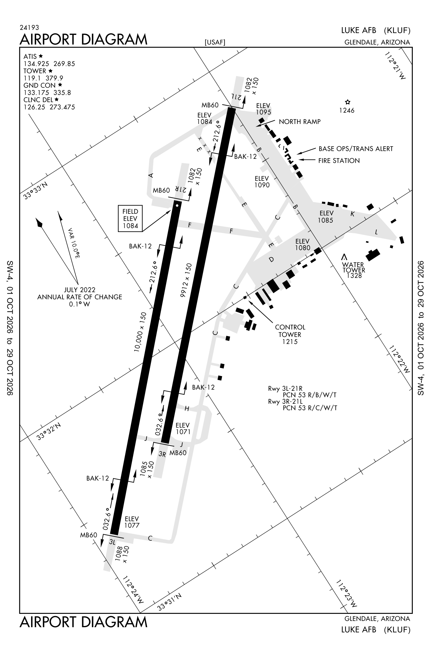
For understanding the field, not for navigation.
| Runway | Length × width | Surface | Lights |
|---|---|---|---|
| 03L/21R | 10,000 × 150 ft | Concrete | High-intensity lights |
| 03R/21L | 9,912 × 150 ft | Concrete | High-intensity lights |
- Runway 03L: PAPI, four lights on the left
- Runway 21R: PAPI, four lights on the left, right-hand traffic pattern
- Runway 03R: localizer and glideslope, PAPI, four lights on the left, approach lights with sequenced flashers (ALSF-1)
- Runway 21L: localizer and glideslope, PAPI, four lights on the left, approach lights with sequenced flashers (ALSF-1), right-hand traffic pattern
Radio frequencies
| ATIS (recorded airport information) | 134.925 | Luke |
| Clearance delivery | 126.25 | Luke |
| Ground | 133.175 | Luke |
| Tower | 119.1 | Luke |
| Approach and departure · Lenni and star North | 118.15 | Luke |
| Approach and departure South | 125.45 | Luke |
| Emergency | 121.5 | Luke |
| Prescott and center (remote transmitter) Low | 128.45 | Luke |
Aircraft registered in Glendale from the FAA register
159 aircraft are registered to owners in Glendale, Arizona: 111 piston singles, 14 balloons, 10 piston twins, 6 turboprops, 5 helicopters. Not every one of them is based at this airport; the based-aircraft count above is the FAA's figure for this airport alone.
Companies and organisations in town with two or more aircraft:
Individuals are counted, not named (the site's policy at this time). All aircraft registered in Arizona.
Fuel and services as reported to the FAA
- Fuel
- Jet A with additives
- Repairs
- airframe and engine: major repairs
- Parking
- hangars
- Oxygen
- bottled oxygen (high- and low-pressure), bulk oxygen (high- and low-pressure)
- Also here
- cargo handling
Nearest fields reporting avgas: Glendale Regional (4 nm east), Phoenix Goodyear Airport (7 nm south), Buckeye Municipal (17 nm southwest), Phoenix Deer Valley Airport (18 nm northeast).
Other fields with jet fuel nearby: Glendale Regional (4 nm east), Phoenix Goodyear Airport (7 nm south), Buckeye Municipal (17 nm southwest).
The FAA's file records what is sold and done at the field, as the airport manager reports it, not who sells it or the price; fuel sellers (FBOs) are not named in any public file. Airports selling jet fuel in Arizona · avgas.
Who works here from the FAA's certificate lists and the register
Charter operators and airlines based in Glendale:
- Freedomair, LLC. 1 aircraft on the certificate Freedom Air operates private jet charter services and flight training programs based in the Chicago area.
- Airwest Helicopters L L C 1 aircraft on the certificate Airwest Helicopters is a helicopter operator based in Glendale, Arizona, offering charter services, utility operations, heavy lift/longline operations, firefighting, aerial photography and film services, electronic news gathering, and law e
Repair stations in Glendale:
- Castle Aeronautics, LLC
- Euravia Engineering and Supply CO. LTD Euravia North America, located in Glendale, Arizona, is a Part 145 FAA-certified repair station and part of the Magellan Aerospace group.
- Fox Aviation Services LLC Fox Aviation Services LLC is an FBO at Glendale Airport in Arizona, offering private hangar transfers, ramp parking, and ground services.
- Glendale Blackhawk Maintenance, LLC
- Parker Hannifin CORP.
- Skyquest Aviation, LLC
- Unical 145 , LLC Unical 145, LLC is a repair station and aircraft parts supplier based in Glendale, Arizona.
Companies in the same town as this airport; not every one of them works from this field. All operators · all repair stations · all flight schools · all FBOs.
Accidents and incidents at or near this airport NTSB records · 4 since 1982, 1 fatal
Cases the NTSB recorded with this as the nearest airport, newest first. Each opens the full report in plain English. The country as a whole: Where accidents happen.
Nearby within 30 nautical miles
The FAA's remarks as written in the airport file, spelled out
- DUSK-0530Z MON-THUR, DUSK-0130Z Friday.
- Rdcd level rescue and firefighting (ARFF) cpbltys cat 1-7; critical level rescue and firefighting (ARFF) cpbltys cat 8-10; wkend and holidays further rdc cpbltys. Svr risk loss; rescue and firefighting (ARFF) not expd to extinguish interior fire or successful rescue operations. Ltd exterior rescue and firefighting (ARFF) performed - amgmt to verify.
- Afld unlgt when closed.
- Hook base leg runway 21 outside housing area, 1 NM. base leg runway 03 avoid PHOENIX-GOODYEAR airport, 4 NM. overhead 300 kias, 3100 feet above sea level until 5 DME then 2600 feet above sea level - conventional 2100 feet above sea level.
- Closed wkend, holidays and family days.
- MB60 (35 feet ovrn) hook BAK-12B (1441 feet).
- MB60 (33 feet ovrn) hook BAK-12B (1419 feet).
- MB60 (34 feet ovrn) hook BAK-12B (1454 feet).
- MB60 (35 feet ovrn) hook BAK-12B (1511 feet).
- Ctn: light pole 1200 feet southeast centerline 456 feet and 676 feet from runway 21L threshold; light pole 1430 feet southwest centerline 676 feet from runway 21L threshold.
- Restricted: hover landing NA WO the control tower permission.
- Restricted: all aircraft required flight plan prior to departure.
Connections how this airport links to the rest of the register
- Aircraft registered in Glendale 159 aircraft · 111 piston singles, 14 balloons, 10 piston twins
- Pyramid Pool LLC 5 aircraft in town
- Industrial Aerobotics LLC 5 aircraft in town
- Unical Aviation INC 4 aircraft in town
- Open Air LLC 2 aircraft in town
- Freedomair, LLC. 1 aircraft on the certificate · charter operator
- Airwest Helicopters L L C 1 aircraft on the certificate · charter operator
- Castle Aeronautics, LLC · repair station
- Euravia Engineering and Supply CO. LTD · repair station
- Fox Aviation Services LLC · repair station
- Glendale Blackhawk Maintenance, LLC · repair station
- NTSB accidents and incidents at or near this airport 4 since 1982 · 1 fatal
- Accidents and incidents in Arizona 2,983 since 1982 · 468 in the last ten years
- Nearby landing places within 30 nautical miles 8 airports, heliports and seaplane bases
- Public-use airports in Arizona 77 landing places
- Arizona 8,395 aircraft registered
The whole map of how records connect · these connections as data: /graph/airport/LUF.json.
Facts from the FAA's airport file effective October 1, 2026, written out in plain English; weather from the National Weather Service's aviation weather service; registered aircraft from the FAA register as of October 9, 2026; accidents from the NTSB's public database. Owners are shown only when they are an organisation; no person is named. Check the official sources before a flight: this page is for understanding an airport, not for planning one.