
Wallops Flight Facility Airport
WAL · KWAL · Wallops Island, Virginia · Accomack County · map
Wallops Flight Facility Airport is a private airport, 5 miles south of Wallops Island, Virginia, 40 feet above sea level. It has 3 runways; the longest, 04/22, is 8,748 feet of asphalt and concrete. It has a control tower and fuel (Jet A).
Private use: permission from the owner is required before landing here.
The airport
- Codes
- FAA WAL · ICAO KWAL
- Kind
- Airport · private use, permission required · publicly owned
- Elevation
- 40 feet above sea level
- Control tower
- A control tower · operates 1200-2200z++ mon-fri except fed holidays and by notam.
- Attended
- around the clock
- Lights
- beacon see the remarks below
- Fuel and services
- Jet A; the services card below
- On the chart
- Washington sectional
- Magnetic variation
- 11W
- In the FAA's files since
- July 1943
Runways 3
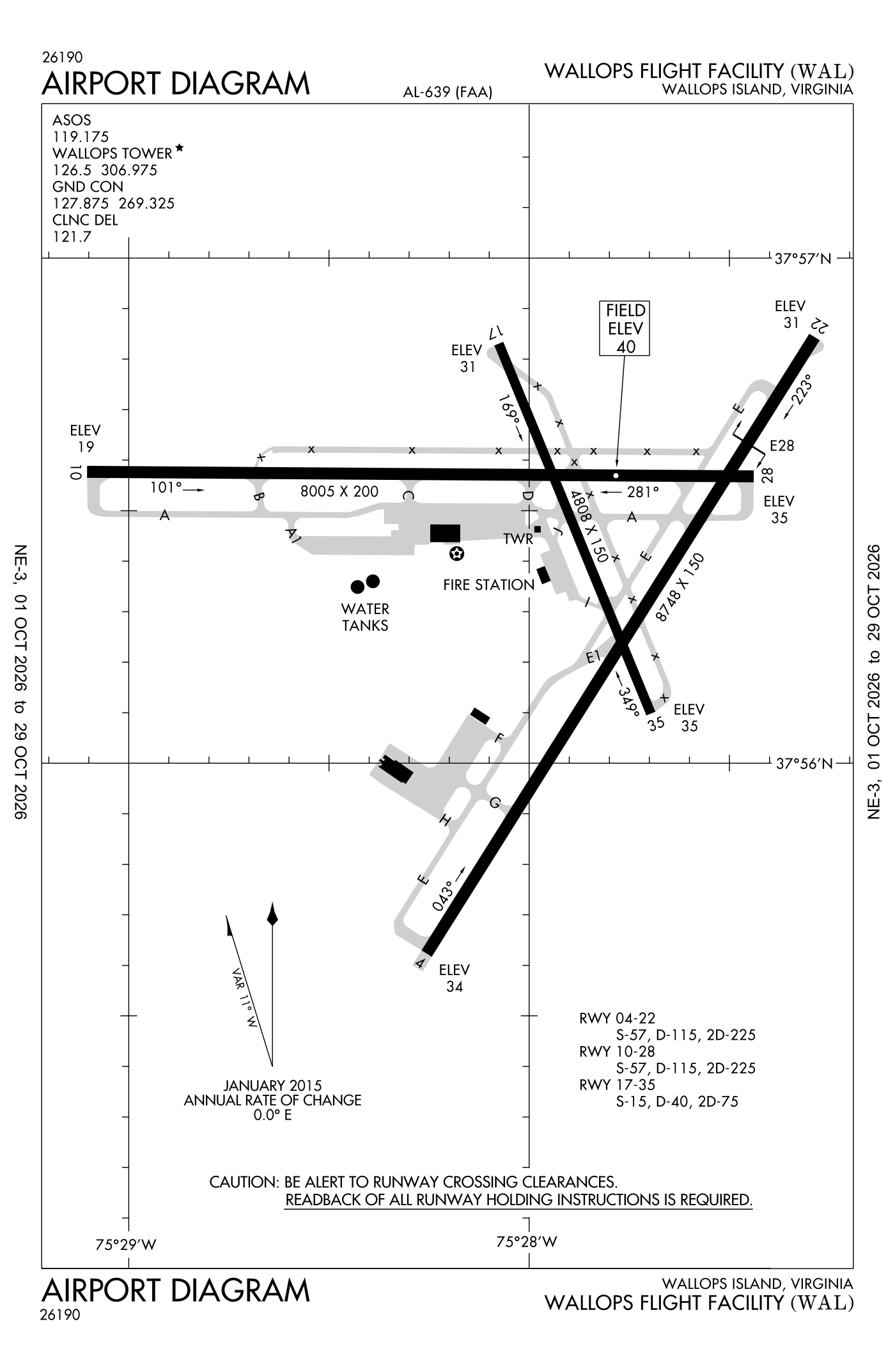
For understanding the field, not for navigation.
| Runway | Length × width | Surface | Lights |
|---|---|---|---|
| 04/22 | 8,748 × 150 ft | Asphalt and concrete, good | High-intensity lights |
| 10/28 | 8,005 × 200 ft | Asphalt and concrete, good | High-intensity lights |
| 17/35 | 4,808 × 150 ft | Asphalt, good | High-intensity lights |
- Runway 04: PAPI, four lights on the left
- Runway 22: PAPI, four lights on the left
- Runway 10: PAPI, four lights on the left
- Runway 28: PAPI, four lights on the left
- Runway 17: PAPI, four lights on the left
- Runway 35: PAPI, four lights on the left
Radio frequencies
| Common traffic advisory (CTAF) · Tower | 126.5 | Wallops |
| Clearance delivery | 121.7 | Wallops |
| Ground | 127.875 | Wallops |
| Approach (secondary) Departure (secondary) When nhk approach closed | 127.2 | Wallops |
| Approach and departure | 127.95 | Wallops |
| Wal and automated weather (ASOS) | 119.175 |
Automated weather (ASOS), by phone 757-791-3785.
Aircraft registered in Wallops Island from the FAA register
5 aircraft are registered to owners in Wallops Island, Virginia: 3 turboprops, 2 drones. Not every one of them is based at this airport; the based-aircraft count above is the FAA's figure for this airport alone.
Companies and organisations in town with two or more aircraft:
Individuals are counted, not named (the site's policy at this time). All aircraft registered in Virginia.
Fuel and services as reported to the FAA
- Fuel
- Jet A
- Repairs
- none at the field, as reported
Nearest fields reporting avgas: Crisfield-Somerset County (18 nm west), Accomack County (22 nm southwest), Salisbury-Ocean City Wicomico Regional (24 nm north), Ocean City Municipal (27 nm northeast).
Other fields with jet fuel nearby: Accomack County (22 nm southwest), Salisbury-Ocean City Wicomico Regional (24 nm north), Ocean City Municipal (27 nm northeast).
The FAA's file records what is sold and done at the field, as the airport manager reports it, not who sells it or the price; fuel sellers (FBOs) are not named in any public file. Airports selling jet fuel in Virginia · avgas.
Accidents and incidents at or near this airport NTSB records · 1 since 1982, 0 fatal
Cases the NTSB recorded with this as the nearest airport, newest first. Each opens the full report in plain English. The country as a whole: Where accidents happen.
Nearby within 30 nautical miles
The FAA's remarks as written in the airport file, spelled out
- Existed prior to 1959.
- For rotating beacon call the common traffic frequency.
- Uhf the common traffic frequency - 306.975.
- Extensive research test development in progress.
- Hook E28(B) (1500 feet).
- 166 feet high radar dish 800 feet R of approach 22.
- 510 feet catv tower 4 MI off approach runway 28.
- Numerous radar facilities at airport with possible radio frequency hazard to ordnance.
- Military turboprop training daily until 2300L.
- Fclp equipment directly adjacent to left side of runway 10 1:35 pm to 5:25 pm feet from approach end. Fclp equipment directly adjacent to left side of runway 28 1:40 pm to 5:25 pm feet from approach end.
- Touch and go landings NA when the control tower closed.
- Runway 17/35 closed when the control tower closed.
Connections how this airport links to the rest of the register
- Aircraft registered in Wallops Island 5 aircraft · 3 turboprops, 2 drones
- Sentinel Robotic Solutions LLC 2 aircraft in town
- National Aeronautics & Space Administration 2 aircraft in town
- NTSB accidents and incidents at or near this airport 1 since 1982 · 0 fatal
- Accidents and incidents in Virginia 1,361 since 1982 · 230 in the last ten years
- Nearby landing places within 30 nautical miles 8 airports, heliports and seaplane bases
- Public-use airports in Virginia 64 landing places
- Virginia 5,986 aircraft registered
The whole map of how records connect · these connections as data: /graph/airport/WAL.json.
Facts from the FAA's airport file effective October 1, 2026, written out in plain English; weather from the National Weather Service's aviation weather service; registered aircraft from the FAA register as of October 9, 2026; accidents from the NTSB's public database. Owners are shown only when they are an organisation; no person is named. Check the official sources before a flight: this page is for understanding an airport, not for planning one.