
Eareckson AS Airport
SYA · PASY · Shemya, Alaska · Aleutian Islands County · map
Eareckson AS Airport is a private airport owned by U S Air Force in Shemya, Alaska, 98 feet above sea level. Its one runway, 10/28, is 10,004 feet of asphalt.
Private use: permission from the owner is required before landing here.
The airport
- Codes
- FAA SYA · ICAO PASY
- Kind
- Airport · private use, permission required · owned by the Air Force
- Owner
- U S Air Force
- Elevation
- 98 feet above sea level
- Control tower
- No control tower
- Attended
- Monday to Friday, 6:00 pm to 0300z++ closed wkend and holidays
- Lights
- runway lights see the remarks below; beacon sunset to sunrise
- Fuel and services
- no fuel reported; the services card below
- On the chart
- W Aleutian Isls sectional
- Magnetic variation
- 1E
- In the FAA's files since
- May 1949
Runway
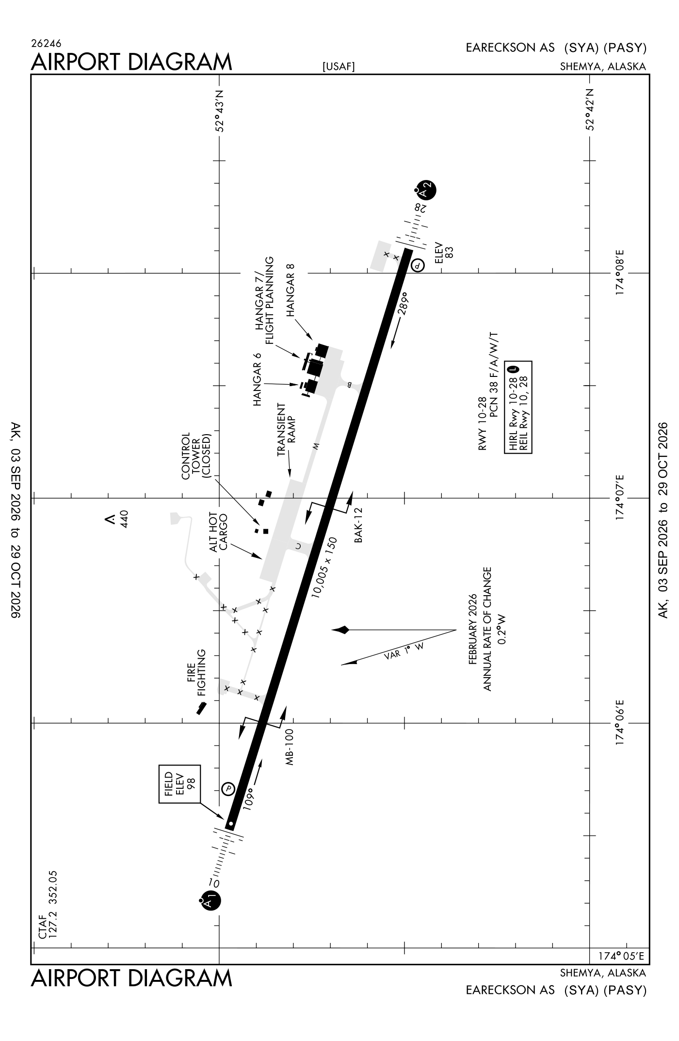
For understanding the field, not for navigation.
| Runway | Length × width | Surface | Lights |
|---|---|---|---|
| 10/28 | 10,004 × 150 ft | Asphalt | High-intensity lights |
- Runway 10: PAPI, four lights on the left, approach lights with sequenced flashers (ALSF-1), right-hand traffic pattern
- Runway 28: localizer and glideslope, PAPI, four lights on the left, SALSF
Radio frequencies
| Common traffic advisory (CTAF) | 127.2 | |
| Shemya and center (remote transmitter) Low/high | 119.1 |
Aircraft registered in Shemya from the FAA register
No aircraft on the register list Shemya, AK as the owner's town.
Fuel and services as reported to the FAA
- Fuel
- none reported
- Parking
- hangars
- Also here
- cargo handling
The FAA's file records what is sold and done at the field, as the airport manager reports it, not who sells it or the price; fuel sellers (FBOs) are not named in any public file. Airports selling jet fuel in Alaska · avgas.
Accidents and incidents at or near this airport NTSB records
No NTSB accident or incident records name this airport.
The FAA's remarks as written in the airport file, spelled out
- 352.050 uhf.
- Customs unavailable.
- Rescue and firefighting (ARFF) index 7C
- Hills 8 NM west 662 feet above sea level.
- Activate ALSF1 runway 10; salsf runway 28; high-intensity runway lights runway 10/28 - the common traffic frequency. PAPI runway 10 and 28 operates continuously.
- 8:00 am to 5:00 pm.
- Christina bolle
- D317-392-3362/C907-392-3362.
- MB100 (B) 1850 feet unusable.
- BAK12(B) 4450 feet.
- Ctn: 150 feet turn radius maximum; tow bar and personnel for large commercial aircraft rqrg gtr than 150 feet turnaround NA; 25 feet shoulders emergency only WI group index and gross loads. No overrun; sheer drop offs.
- With 25 feet shoulders.
Connections how this airport links to the rest of the register
- Accidents and incidents in Alaska 5,930 since 1982 · 829 in the last ten years
- Public-use airports in Alaska 392 landing places
- Alaska 9,146 aircraft registered
The whole map of how records connect · these connections as data: /graph/airport/SYA.json.
Facts from the FAA's airport file effective October 1, 2026, written out in plain English; weather from the National Weather Service's aviation weather service; registered aircraft from the FAA register as of October 9, 2026; accidents from the NTSB's public database. Owners are shown only when they are an organisation; no person is named. Check the official sources before a flight: this page is for understanding an airport, not for planning one.