
Keesler Air Force Base
BIX · KBIX · Biloxi, Mississippi · Harrison County · map
Keesler Air Force Base is a private airport owned by Usaf in Biloxi, Mississippi, 33 feet above sea level. Its one runway, 04/22, is 7,630 feet of partially concrete. It has a control tower and fuel (Jet A with additives).
Private use: permission from the owner is required before landing here.
Weather right now KBIX · observed 5:55 pm CDT (22:55 UTC), 37 minutes ago
VFR good flying weather
- Wind from the east-southeast (110°) at 6 knots
- Visibility 10 miles or more
- Sky: scattered clouds at 3,700 feet
- Temperature 82°F (28°C), dew point 69°F (21°C)
- Altimeter 29.87 inHg
The forecast issued Tue 1:00 pm CDT (18:00 UTC), good until Wed 7:00 pm CDT (00:00 UTC)
- From Tue 1:00 pm CDT (18:00 UTC): wind from the east-northeast at 12 knots, gusting to 18, scattered clouds at 2,500 feet, a broken layer at 5,000 feet and more above VFR
- Changing between Tue 7:00 pm CDT (00:00 UTC) and 8:00 pm CDT (01:00 UTC) to: wind from the northeast at 12 knots, a few clouds at 5,000 feet, scattered clouds at 15,000 feet
- Changing between Wed 9:00 am CDT (14:00 UTC) and 10:00 am CDT (15:00 UTC) to: wind from the east-northeast at 12 knots, gusting to 20, scattered clouds at 4,000 feet, scattered clouds at 18,000 feet
The codes as issued (METAR and TAF)
METAR KBIX 062255Z AUTO 11006KT 10SM SCT037 28/21 A2987 RMK AO2 SLP118 T02800208
TAF KBIX 061800Z 0618/0724 06012G18KT 9999 SCT025 BKN050 BKN150 QNH2983INS BECMG 0700/0701 04012KT 9999 FEW050 SCT150 QNH2982INS BECMG 0714/0715 06012G20KT 9999 SCT040 SCT180 QNH2986INS TX29/0620Z TN22/0710Z
From the National Weather Service's aviation weather service, refreshed every few minutes; times are local to the airport with UTC in brackets. For a flight, get your briefing from Flight Service or an approved provider.
The airport
- Codes
- FAA BIX · ICAO KBIX
- Kind
- Airport · private use, permission required · owned by the Air Force
- Owner
- Usaf
- Elevation
- 33 feet above sea level
- Control tower
- A control tower · mon-fri 1400-0500z++, closed holidays.
- Attended
- Monday to Friday, 2:00 pm to 0500z++; weekends, irregular hours
- Lights
- runway lights sunset to sunrise; beacon sunset to sunrise
- Fuel
- Jet A with additives
- Repairs
- airframe: major repairs; engine: major repairs
- Parking
- hangar
- On the chart
- New Orleans sectional
- Magnetic variation
- 2W
- In the FAA's files since
- April 1940
Runway
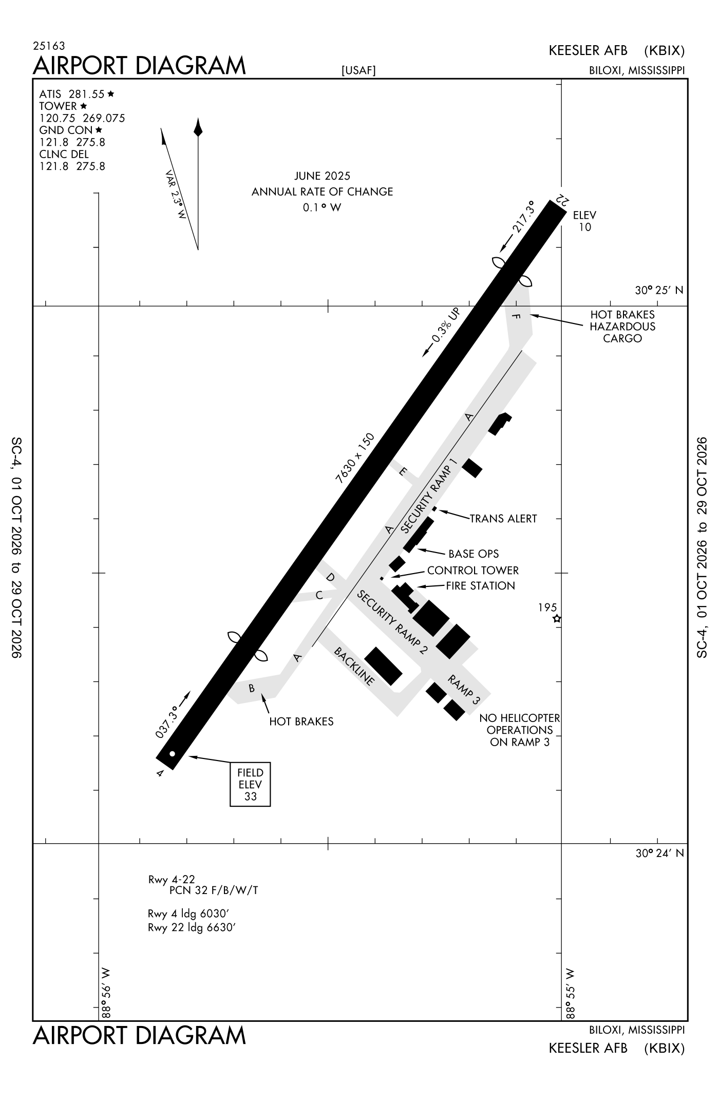
For understanding the field, not for navigation.
| Runway | Length × width | Surface | Lights |
|---|---|---|---|
| 04/22 | 7,630 × 150 ft | Partially concrete | High-intensity lights |
- Runway 04: PAPI, four lights on the left, threshold displaced 1,600 ft
- Runway 22: ILS, PAPI, four lights on the left, approach lights with sequenced flashers (ALSF-1), right-hand traffic pattern, threshold displaced 1,000 ft
Radio frequencies
| Clearance delivery · Ground | 121.8 | Keesler |
| Tower | 120.75 | Keesler |
| Approach and departure arriving from headings 130 to 309 | 124.6 | Keesler |
| Approach and departure arriving from headings 310 to 129 | 127.5 | Keesler |
| Mobile and center (remote transmitter) Low | 127.65 | Keesler |
Aircraft registered in Biloxi from the FAA register
23 aircraft are registered to owners in Biloxi, Mississippi: 21 piston singles, 1 turboprop, 1 gyroplane. Not every one of them is based at this airport; the based-aircraft count above is the FAA's figure for this airport alone.
Companies and organisations in town with two or more aircraft:
Individuals are counted, never named. All aircraft registered in Mississippi.
Accidents and incidents at or near this airport NTSB records
No NTSB accident or incident records name this airport.
Nearby within 30 nautical miles
The FAA's remarks as written in the airport file
- Overhead 1500 feet; conventional 1000 feet.
- Closed holidays.
- Non standard length 2000 feet.
- Lighted water tower located 1775 feet right of centerline runway 04 and 2900 feet left of centerline runway 22.
- Caution: first 100 feet concrete spherical bollards located 440 feet southwest of cntln.
- Bash phase II in effective 1 jun - 30 sep; exp heavier bird act sunrise to sunset.
- Restricted: prior permission required all tran aircraft; contact afld mgmt dsn 597-2120. Taxiway east 50 feet width. Aircraft rinse facility (bird bath) taxiway C available to C130 and lrgr. Air crews contact gnd prior to aircraft eng start. All C130 or lrgr must face north on taxiway B for maintenance runs or eng RUN-UPS. pilots will avoid flying ovr usaf medical cntr located on back bay 1 NM east of runway and VA hospital on back bay 1 NM west of runway.
- Tran aircraft ron must arrival by 2100Z++ MON-FRI by 2200Z++ Sunday.
- Caution: marina trees hinder wind, LO wind speed on runway 22 when wind dir from 280-340. Dur augmentation/back up; ltd weather obsn to east and visibility mkr beyond 1 SM only available in the west to north sector, night flood light hinder cloud and visibility obsn, and ceil fre 100-200 feet LO than obsn on runway 22 approach from NOV-MAR.
- Misc: hngr space not available for svr weather. Comsec materials are not available.
- Jasu: 1(MA-1A); 3(A/M32-86A).
- Fluid: SP presair lpox lox.
Facts from the FAA's airport file effective October 1, 2026, written out in plain English; weather from the National Weather Service's aviation weather service; registered aircraft from the FAA register as of October 5, 2026; accidents from the NTSB's public database. Owners are shown only when they are an organisation; no person is named. Check the official sources before a flight: this page is for understanding an airport, not for planning one.