
San Nicolas Island Nolf Airport
NSI · KNSI · San Nicolas Island, California · Santa Cruz County · map
San Nicolas Island Nolf Airport is a private airport owned by the US Navy in San Nicolas Island, California, 506 feet above sea level. Its one runway, 12/30, is 10,002 feet of partially concrete. It has a control tower.
Private use: permission from the owner is required before landing here.
Weather right now KNSI · observed 6:53 am PDT (13:53 UTC), 2153 minutes ago
VFR good flying weather
- Wind from the northwest (310°) at 14 knots
- Visibility 10 miles or more
- Temperature 63°F (17°C), dew point 61°F (16°C)
- Altimeter 29.67 inHg
No terminal forecast is issued for this station. The nearest forecast is usually at the closest larger airport.
The codes as issued (METAR and TAF)
METAR KNSI 101353Z AUTO 31014KT 10SM CLR 17/16 A2967 RMK AO2 SLP039 T01720161 $
From the National Weather Service's aviation weather service, refreshed every few minutes; times are local to the airport with UTC in brackets. For a flight, get your briefing from Flight Service or an approved provider.
The airport
- Codes
- FAA NSI · ICAO KNSI
- Kind
- Airport · private use, permission required · owned by the Navy
- Owner
- US Navy
- Elevation
- 506 feet above sea level
- Control tower
- A control tower · 7:00 am to 4:30 pm mon-fri
- Lights
- runway lights see the remarks below; beacon sunset to sunrise
- Fuel and services
- no fuel reported; the services card below
- On the chart
- Los Angeles sectional
- Magnetic variation
- 12E
- In the FAA's files since
- May 1941
Runway
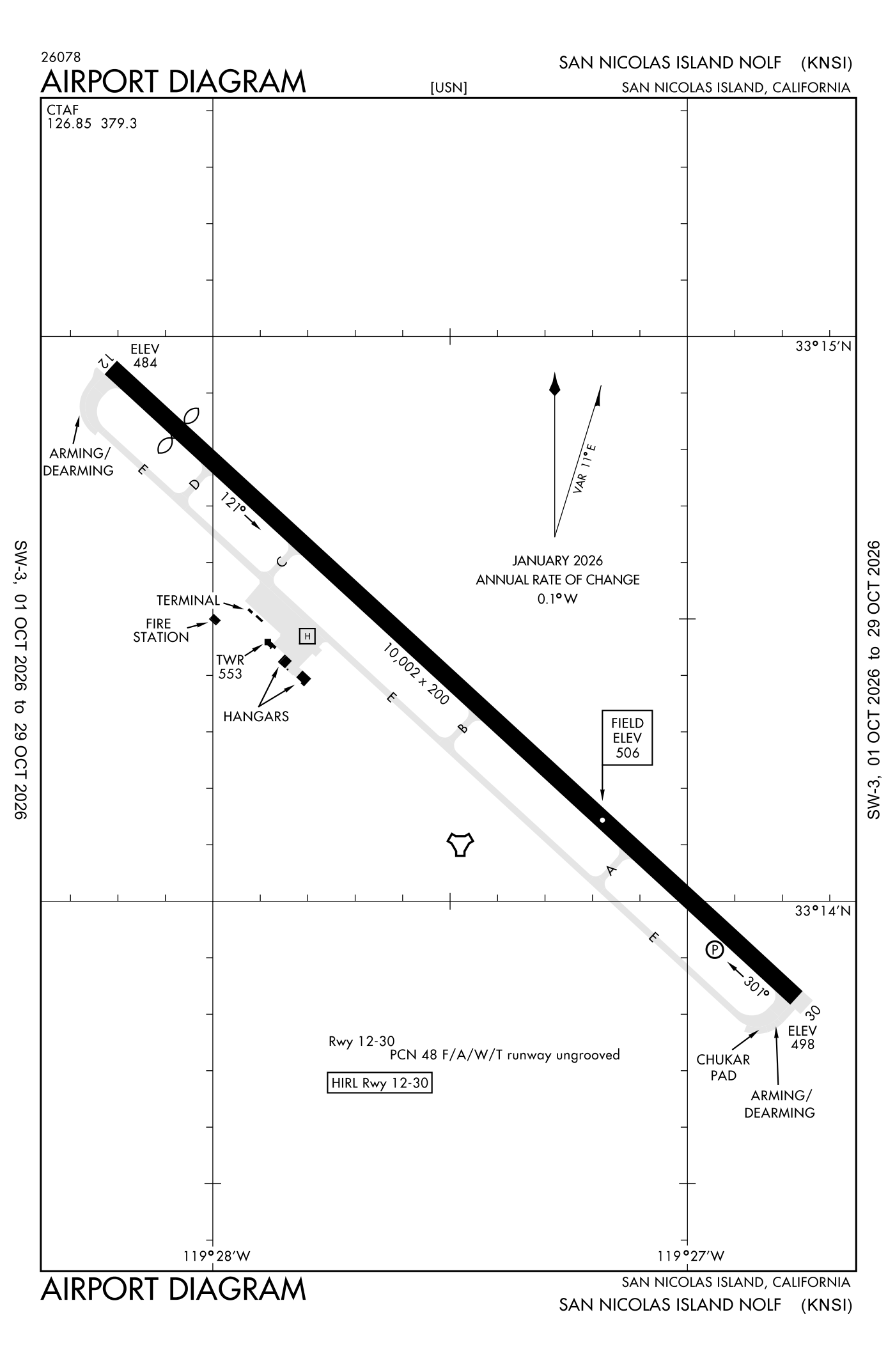
For understanding the field, not for navigation.
| Runway | Length × width | Surface | Lights |
|---|---|---|---|
| 12/30 | 10,002 × 200 ft | Partially concrete | High-intensity lights |
- Runway 12: threshold displaced 992 ft, 9,010 ft available for landing
- Runway 30: PAPI, four lights on the left, right-hand traffic pattern
Radio frequencies
| Tower | 126.85 | Navy Nicholas |
| Emergency | 121.5 | Navy Nicholas |
| Operations Plead con | 132.425 | Navy Nicholas |
Aircraft registered in San Nicolas Island from the FAA register
No aircraft on the register list San Nicolas Island, CA as the owner's town.
Fuel and services as reported to the FAA
The FAA's record lists no fuel or services for this airport.
The FAA's file records what is sold and done at the field, as the airport manager reports it, not who sells it or the price; fuel sellers (FBOs) are not named in any public file. Airports selling jet fuel in California · avgas.
Accidents and incidents at or near this airport NTSB records
No NTSB accident or incident records name this airport.
The FAA's remarks as written in the airport file, spelled out
- Available only during hours of operation.
- Jasu: 1(GTC-85) 1(NC-10C) 1(NCPP-105)
- Traffic pattern: right traffic runway 30.
- Caution: poss turb short final runway 30.
- Fuel: J5 (military)
- Restricted: runway 12 takeoff and landing 9002 feet.
- Operates 1500-2400Z++ MON-THU/ALTN Friday. Closed altn Friday; all Saturday, Sunday and holidays.
- Restricted: possible divert all aircraft except emergency to PT mugu naws due drone misl operates.
- NS abtmt: remain at least 1 mile offshore or 1000 feet above sea level.
- Misc: call plead con 127.55/280.7 or point mugu approach 128.65/325.0 prior to entering W289.
- Ctn unlit wind turbines approximately 160 feet tall located between 3930 feet and 6105 feet south of the runway centerline.
- Misc: first 500 feet runway 12/30 concrete; remainder porous friction surface.
Connections how this airport links to the rest of the register
- Accidents and incidents in California 9,069 since 1982 · 1,094 in the last ten years
- Public-use airports in California 244 landing places
- California 27,552 aircraft registered
The whole map of how records connect · these connections as data: /graph/airport/NSI.json.
Facts from the FAA's airport file effective October 1, 2026, written out in plain English; weather from the National Weather Service's aviation weather service; registered aircraft from the FAA register as of October 9, 2026; accidents from the NTSB's public database. Owners are shown only when they are an organisation; no person is named. Check the official sources before a flight: this page is for understanding an airport, not for planning one.